March 2014 Archives
A remarkable and detailed 1921 map of Tulsa is available for viewing online, from the Special Collections of the University of Tulsa McFarlin Library. The inset map shows the entire city, and is captioned;
TULSA
AND ADDITIONS
A Ready Reference and Guide Map to Tulsa's
OFFICE & PUBLIC BLDGS. CLUBS, R.R. PASSENGER &
FREIGHT DEPOTS, SCHOOLS, CHURCHES, PARKS &
CEMETERIES, PAVED & UNPAVED STREETS & NAMES,
STEAM, INTERURBAN & STREET RAILROADS,
FIRE PLUGS, CITY & FIRE LIMITS
Subdivisions are clearly labeled. Around the edges of the map are alphabetical listings of the categories mentioned above, plus banks, streets, hospitals, apartment buildings, and hotels. The street car and interurban lines are very easy to spot.
The outer part of the map depicts "Tulsa's industrial and commercial district : showing office and public bldgs. R.R. passenger & freight depots." It is more detailed, labeling individual buildings, and it covers a solid rectangle from Denver to Hartford, Easton to 5th St., plus extensions in to the west (to Frisco between Easton & 2nd), to the east (to 3rd & Madison and Admiral & Owasso), and to the south (to 12th and Main). Beyond these areas are residences and farmland.
Two publishers are listed on the map, the Dean-Brumfield Co. of Tulsa and the Standard Map Co. of Chicago.
Also in the collection is the Fowler & Kelly Aero View of Tulsa, 1918 (UPDATE: The Library of Congress has a clearer, higher-resolution digital copy of Aero View of Tulsa, 1918.)
The only disappointment about these two maps is that they appear to have been converted to JPEG format, which is great for photos of real life, but produces annoying blurs and other artifacts as a result of its lossy compression algorithm. PNG, a lossless compressed format, would have been a better choice.
UPDATE: Paul Uttinger provides a link to a better copy of the Aero View of Tulsa, 1918.
UPDATE 2021/05/26: Replacing dead links. The University of Tulsa has moved to a new digital archive system. For the record, here are the dead links to old locations of the 1921 map and the Aero View of Tulsa, 1918 on oclc.org.
 On April Fools' Day, next Tuesday, April 1, 2014, Tulsa County voters have a special election to raise taxes to pay for an addition to the Tulsa County Jail and a brand new juvenile justice facility. I will be voting no on both questions.
Ronda Vuillemont-Smith of the Tulsa 9/12 Project has run the numbers and says we could meet the claimed needs from expected Vision 2025 surplus funds.
Tax-increase supporters are saying we can't commit the Vision 2025 surplus until the final penny is collected, but that's not so. There's a clear precedent: On July 18, 2006, the Tulsa County Vision Authority met to authorize the allocation of $45.5 million of the projected Vision 2025 surplus to fund completion of the over-budget, starchitect-designed BOK Center arena. That was a full 10 years before the tax expires. Now the expiration date is only 2.75 years away; surely the county financial wizards know exactly how much principal and interest we owe on bonds, what's held in reserve, what's committed on any remaining projects. The only unknown is exactly how much more tax we're likely to take in on sales between now and December 31, 2016 (with the final payment from Oklahoma Tax Commission in February 2017), and we can make a pretty good estimate of that for such a short term.
Tax-increase supporters are saying we can't use the Vision 2025 surplus for anything except economic development projects. But surely the creative minds that crammed an arena, school books, a health clinic, and college buildings under the "economic development" ballot heading (Prop. 3) in 2003 can find an economic development rationale for a juvenile justice facility. And Prop. 4 of Vision 2025 was "capital improvements for community enrichment" -- surely a jail pod and juvenile justice facility would qualify. And if there were any doubt about whether they'd qualify, a public vote to abolish and re-enact those taxes for these new purposes would take care of the legalities.
Tax-increase supporters are saying that we promised the suburbs $45.5 million of the surplus for "fun money" because Tulsa got $45.5 million extra for the arena. But in 2007, during the debate over the River Tax, officials denied that any such commitment was made:
Miller claims that we can't predict if there would be enough surplus, and if there is any, it's already been promised to the suburbs for unspecified projects.But I'm told that no such projects have been approved by the Tulsa County Vision Authority and no such commitment was made. Mayor Taylor denies that any such promise was made.
The Tulsa County Vision Authority is the only body authorized to repurpose Vision 2025 funds, so where are the meeting minutes where these reallocations to suburban projects were made?
Is there enough money left? Page 48 of the February 2014 Vision 2025 report (Funding Report as of 3/4/2014, p. 4 of 4) says that the current funding for all projects totals $573,458,804.20. Page 43 of the report has the total tax receipts as of February 9, 2014, at $547,256,173.29. At the current rate of collection of about $5 million per month, we will reach full funding in about five months. From that point forward, everything else the tax collects should be gravy, unless some important facts have been left out of the report. That means, using the county's very modest growth estimate, $157,068,231.53 remaining and uncommitted. That's enough to fund the suburbs' special projects and the jail and juvenile justice facility.
In 2005, Tulsa County officials said if "4 to Fix the County II" passed, they'd fix the juvenile justice center for about $2.5 million. In 2012, they asked for $38 million as part of Vision2 to build a new juvenile justice center. Now they want $45 million, plus who knows how much interest to finance that amount over 15 years. Should we trust them? What is the basis of estimate? Are there less expensive alternative locations?
Sometimes it seems that we have exactly one county elected official that puts our interests above the empire-building impulses of some county officials. County commissioners who were looking out for our best interests would first give us the choice to repurpose expected surplus funds and use a tax hike as a fall back, not the other way around.
Two arguments in favor of these tax propositions puzzle me, One is the sheriff's argument that the jail has effectively become a mental health treatment facility for many inmates, so we need a special pod for people with mental illness. Maybe we just need to work with social service organizations to keep such people supervised and appropriately medicated.
The other puzzler is the complaint that, in the current juvenile facility, juvenile offenders and juvenile victims are waiting in the same waiting rooms, Why would you send juvenile victims of crime or juveniles in family transition to the same facility of juveniles that are accused of committing a crime?
Rep. Jason Murphey (R-Guthrie) calls shenanigans on dumping more money in the American Indian Cultural Center and Museum (AICCM) money pit:
Several days ago the State Senate approved Senate Bill 1651 in another attempt to use taxpayer funds to complete the construction of the American Indian Cultural Center and Museum in Oklahoma City. The bill, if approved by the House and Governor, would spend another 40 million taxpayer dollars on the project.The cultural center has already been provided with three allocations of $33M, $25M and $5M. The appropriations were funded with debt part of which still haunts the state budget and will continue to do so for many years....
Murphey went on to summarize a performance audit of the Native American Cultural and Education Authority by State Auditor Gary Jones that found "a number of inconsistencies and deficiencies that can be attributed to improper planning," a failure to implement best budgeting practices, and exploration of alternative plans and less expensive options. He writes, "It's hard to believe that Oklahoma lawmakers are so gullible as to suggest that the fourth time's the charm and this money will not also be wasted, contrary to all previous evidence." He reports that he has received more unprompted email from his constituents on this topic than any other, almost all opposed to putting more money into this failed project.
Oklahoma's tribal heritage is certainly worthy of celebration and promotion, and we have many museums, cultural centers, and historical sites, some run by the tribes, some under our state parks department or the state historical society, some under independent non-profits. Tulsa, in particular, ought to pursue tourists with an interest in American Indian history and culture, selling our city as the logical home base for day trips to Tahlequah, Muskogee, Okmulgee, Pawhuska, and elsewhere, not to mention our own sites of significance, like the Gilcrease Museum, Creek Council Oak, and Perryman Cemetery.
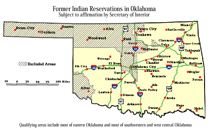
Oklahoma City, on the other hand, is in the Unassigned Lands, opened for settlement by land run 125 years ago next month. It's located in one of the few parts of the state (along with the Cherokee Outlet, No Man's Land, and Old Greer County) that isn't considered Indian Country under Federal Law.
It seems to me that placing a catch-all Indian museum in Oklahoma City is all about Oklahoma City cashing in on tribal tourism at the expense of the rest of the state, drawing tourists away from historic sites and tribal cultural museums in other parts of the state. If anyone should pay for the AICCM, it should be Oklahoma City taxpayers and philanthropists.
Rather than dump another $40 million into a new facility, Oklahoma's focus ought to be on better promotion of the sites that already exist. We should want to entice visitors to venture off of the interstates to our smaller cities and towns, rather than provide them an easy-on, easy-off, fast-food drive-thru version of our state's rich Indian history. The state could fund longer hours at our welcome centers and add small exhibits and brochures to help people find Indian heritage sites. The tourism department could provide an online guide and a mobile app for planning a visit to Indian sites and events.
State funding is for building up the whole state, not for fattening an imperial capital at the expense of the provinces.
MORE:
Don't miss Murphey's insight into the preeminent force behind this kind of spending:
It is never good when a government entity is suddenly empowered with a rapid cash infusion and the spending of millions of dollars of other peoples' money. The officials who oversee that entity all too often give in to the temptation to build an empire and spend the money of future generations at the suggestion of the massive army of vendors who benefit from the excessive spend.
From the NACEA audit:
The Board self-imposed certain challenges; the Legislature requested neither a world-class facility nor one that would draw hundreds of thousands of both international and domestic tourists to the southern side of Bricktown in Oklahoma City. The Board chose "the Vision Plan," the most elaborate and expensive of the options provided by the project architects in 2004. Projects on such a grand scale require substantial funding, however, and at no time has the Board's available funding closely approached its projected expenditures. It is reasonable to expect that funding shortfalls might lead to a reevaluation of the plans by the Board; if an everyday citizen loses his or her job, he or she might eliminate cable service, a gym membership, or weekly pizza night. The Board has taken the opposite approach, and rather than evaluating less costly options that would still allow construction of a world-class facility, has maintained their vision, with an expectation that taxpayers will foot the bill.
The audit's recommendations and six options for moving forward are worth reading.
I. Marc Carlson, Librarian of Special Collections at the University of Tulsa, has several personal webpages containing his research on the Tulsa Race Riot and other historical topics. I just found out about this material earlier this evening and wanted to preserve the links for future exploration:
Tulsa Race Riot of 1921 by I. Marc Carlson: WordPress site, principal location for collected documents and analysis.
Tulsa Race Riot of 1921 original website: Hand-coded website that still has some important material.
Public-domain photos of the Tulsa Race Riot, with descriptions and commentary
Carlson takes a "just the facts" approach to the material, placing the greatest weight on first-hand accounts recorded close to the time of the events and documents of the time, separating evidence from widely-circulated legends. You can read his statement of methodology here. Among his projects are a timeline of the Tulsa Race Riot and a list of the Tulsa Race Riot known dead and wounded, with the source of the information and, if known, the address for the victim as found in contemporary directories.
On Monday, March 24, 2014, the Oklahoma State Senate's Education Committee unanimously passed a committee substitute for HB 3399, a bill initiated in the State House to repeal Oklahoma's adoption of Common Core national standards. (Click the link for the text of the bill, which shows deletions from current law as strikethrough text and additions as underlined text.)
The Senate committee substitute:
- requires Oklahoma to develop its own state subject matter standards and assessments;
- removes explicit references to the Priority Academic Student Skills (PASS) Curriculum, replacing them with references to state-adopted subject-matter standards;
- removes requirements to adhere to K-12 Common Core State Standards, referring instead to "college- and career-ready" standards to be developed in consultation with the State Regents for Higher Education and the State Board of Career and Technology Education;
- gives the Legislature the final say on any standards adopted by the State Board of Education (the Legislature may, by concurrent resolution, amend or return with instructions);
- forbids the State Board of Education from "enter[ing] into any agreement, memorandum of understanding or contract with any federal agency or private entity which in any way cedes or limits state discretion or control over the process of development, adoption or
- revision of subject matter standards and corresponding student assessments in the public school system, including, but not limited to, agreements, memoranda of understanding and contracts in exchange for funding for public schools and programs";
- gives school districts the exclusive right to determine "the instructional materials, curriculum, reading lists and textbooks to be used in meeting the subject matter standards" and the discretion to "adopt additional supplementary student assessments";
- bans standards and assessment questions that are "emotive in nature";
- requires instructional material to be available for inspection by the parents or guardians of students.
"Priority Academic Student Skills (PASS) Curriculum" is the name for Oklahoma's implementation of Common Core standards, as shown by this Oklahoma Common Core adoption timeline on the State Department of Education website.
Restore Oklahoma Public Education ROPE), the bipartisan grassroots group working to repeal Common Core, supports the Senate substitute as a step in the right direction. There were initial indications that the Senate leadership would not allow an anti-Common Core bill to proceed, despite the overwhelming and bipartisan support in the House. Some Common Core opponents are therefore skeptical of any bill that could win the support of the Senate and Governor, but Jenni White, ROPE president, says that it's the first step in a long process which will require Common Core opponents to stay vigilant in this year's elections and in the State Board of Education's development of Oklahoma state subject matter standards.
MORE:
ROPE website
ROPE blog
Stop Common Core in Oklahoma on Facebook
Also, today Indiana Gov. Mike Pence signed a bill to repeal Common Core standards.
A Cato analysis of Oklahoma educational spending and achievement shows that per-pupil spending has nearly doubled in inflation-adjusted terms since 1972, but SAT scores have grown by only 2% in that same period, in raw terms, and have actually dropped by about 2.5% when adjusted for participation and demographics. (The adjustment rationale and methodology are described here.)
And here is Oklahoma Gov. Mary Fallin's rather underwhelming statement on Common Core Legislation from last Friday.
"Since then, I have listened to growing concerns from parents across the state concerning Common Core, the standards currently in the process of being implemented. In light of these concerns, I have worked directly with our legislators to accomplish the goals of increasing classroom rigor and accountability while guaranteeing that Oklahoma public education is protected from federal interference. My hope is that House Bill 3399, which is soon to be heard by the Senate Education Committee, will accomplish these goals. If it does so, without creating unintended consequences that would hamstring educators or invite more federal influence in education, it will have my support."
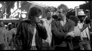
 On Wednesday night, my wife and I went to Circle Cinema to see a double-feature: Locaciones: Buscando a Rusty James (Locations: Looking for Rusty James") followed by Rumble Fish, the 1983 Francis Ford Coppola film based on the novel by S. E. Hinton.
The first film at the Circle Cinema was about the second: Chilean author Alberto Fuguet saw Rumble Fish as a young man and was inspired by the idea that the ordinary stuff of life could be the source of art.
It is the film that incited me to write. The one that said: "You too can do it. If this story of two brothers can be art, then perhaps your world, your raw material, your square meter, can be of some use to you. Perhaps it can be representable."...I left on foot. I lived close by. I arrived at my house that creaked. I remember that that night, in a short time, by hand, without a computer, I wrote my first story. Perhaps I should dedicate it to Dillon. To Spano. Perhaps I should have dedicated it to Coppola.
Some day, I don't know when, I should make a pilgrimage to Tulsa, I told myself.
A flop when released in the US as an ordinary summer movie, Rumble Fish became a long-running cult classic on the art-house circuit in Latin America, particularly in the Southern Cone of Chile, Argentina, and Uruguay. The film was retitled La Ley de la Calle ("The Law of the Street") and presented in English with Spanish subtitles.
Asked to write an essay about a favorite film, Fuguet decided instead to create a documentary tribute. In Miami for an event, he bought a ticket to Tulsa hoping to find locations and to interview extras and local fans who would talk about what Rumble Fish meant to them. Instead, puzzled that the film seemed to mean so little to the people of the city where it was made, he went around on his own, filming locations. Instead of talking to locals, he went back to South America and interviewed authors and filmmakers who were inspired by the film. It was only later that he connected with Tulsans (in particular, Lee Roy Chapman) interested in the film who helped him gather additional footage for his documentary. Fuguet told his tale in This Land Press:
Things didn't turn out as I thought. My goal was to go to Tulsa, stay as long as necessary, talk with everyone, spend time with the extras, and succumb to a world I would have liked to be a part of. But Tulsa turned out to be not just a colorful city, where yes, the clouds pass but not too quickly. I was struck by something that left me lying flat on a bed in a Ramada Inn. Nobody talked to me. Not because they were fleeing from me or they rejected me. It's that Rumble Fish, the film anyway, was not a topic of conversation for them. It hadn't made an impact on the city. It was filmed there but in an informal way, not in the way its big sister, the immense and technicolored The Outsiders, was shot. It was very difficult for me to make a map of locations. There were no fans, no groupies, no cinephiles. I returned to Santiago with a lot of footage and an immense depression. I didn't have a documentary.
Fuguet's homage, Locaciones, is a collection of recent footage of Tulsa interspersed with clips from Rumble Fish shown on various screens, accompanied by the voices of the movie's admirers talking about when and where they first saw it and how it inspired them. It is in Spanish with English subtitles.
(Confession: I've never read the novel Rumble Fish and, until Wednesday night, had never seen the film.)
To Fuguet and his fellow fans, the Tulsa depicted in Rumble Fish is a "holy city." But the film shows a forgotten Tulsa that would have been very foreign to Tulsans who shopped at Woodland Hills Mall and never ventured north of 41st or west of Yale: Under the Boulder Ave. railroad bridge, a store front at 13 E. Brady Street, in the alley south of 5th Street between Main and Boston, the Sixth Street Subway, the 1400 block of S. Cincinnati, the 1000 block of N. Greenwood, 16th Street next to Marquette School, 3rd and Kenosha, the 23rd Street bridge. This was the Tulsa that Tulsa's leaders of the time were diligently working to update or eliminate -- dilapidated, obsolete, old-fashioned. Where they had already succeeded, when Tulsa couldn't provide the requisite flophouse apartment, mom-and-pop drugstore, and dive beer joint, Coppola took his crew to Sapulpa's better-preserved downtown to make up the deficiency.
 The most spectacular scene in the film (from a Tulsa history perspective) is on Greenwood at Archer. The then-recently restored buildings were decked out in neon, awnings, and running lights, and hundreds of extras paraded up and down the block in a scene that was supposed to represent a street party on the wild side of town. While I don't think Greenwood was ever as sleazy as the scene in Rumble Fish, it was as lively, particularly in the '40s and '50s, and Coppola and his set designers do an amazing job of recapturing its lost vitality.
Coppola and Hinton wrote the screenplay on days off during the filming of The Outsiders, and Coppola began shooting Rumble Fish right after the earlier film wrapped. The movie starred Matt Dillon, Mickey Rourke, Diane Lane, Vincent Spano, and Dennis Hopper.
Rumble Fish contains frequent instances of what James Lileks calls "accidental documentary." I found myself wanting to pause every frame, searching blurry backgrounds and plate glass reflections and my own memories for clues that might help me pinpoint the exact location. I didn't follow the story as closely I might have; I was too busy looking at what Tulsa looked like in 1982-1983. (The clock with the flipping ads from Jenks Restaurant even made a prominent appearance.)
Earlier in the evening, I saw an exhibition of photos taken during the filming of Rumble Fish by Gaylord Herron, Joe Cervantez, and Western Doughty, who as a 15-year-old photographed a scene being filmed in his neighborhood, on the south side of Latimer Street between N. Cheyenne and N. Denver Ave. Cervantez had photos of Greenwood and Archer as it was dressed for the film -- tarted up to look like a strip of bars, arcades, news stands, pool halls. He also had a remarkable photo of the buildings on the west side of Greenwood, at the beginning of the restoration process of the handful of post-Riot buildings remaining after the rest had been destroyed in the late '60s by expressway construction and urban renewal. The building facades, propped up by metal poles, were all that remained.
(I'm pretty sure the police officer in the movie was the visual inspiration for Axe Cop. And Vincent Spano totally stole my late '70s - early '80s look.)
WATCH ONLINE:
Locaciones: Buscando a Rusty James is available for streaming on the website of Cinépata.
Rumble Fish is available online at viooz.co. I have no idea whether this site is licensed to show the movie, but it's there.
MORE:
If you've seen Rumble Fish and are wondering what it's all about, here are a couple of reviews that seemed especially insightful. (Warning: reviews contain spoilers.)
This Perhapses review of Rumble Fish does a good job of connecting some seemingly unconnected details in the movie.
Rumble Fish, reviewed by Liam's United States of Cinema, as part of a series of reviews of three movies set in Oklahoma.
Tulsa is not like I imagined it. It is a seedy run-down city, like the Great Falls of Thunderbolt and Lightfoot. There is plenty of space for rumbles in the freight yards, under bridges and down alleyways. Drugs are rife. Yet its isolated position on the plains is made clear. The outside world is all around. Roads are thick with dust, winds whip through the streets, and the hurtling, boiling clouds are continually above, reflected in the storefront windows.
He has some notes on the locations of Benny's Billiards, the fight by the train tracks, Rusty James's apartment, the drugstore, the bridge, and the pet store.
The Oklahoma Historical Society has been scanning and posting documents from their archives, and there is a page full of links to architectural and historical surveys of Oklahoma cities and towns. The surveys were mainly conducted over the past 20 years, often by teams of students led by an architectural historian. The intent of a survey is to identify buildings and districts that may be worthy of placement on the National Register of Historic Places, a status that can convey tax benefits and grant eligibility for restoration. A survey usually includes extensive descriptions of the historical context -- when a town developed, what caused it to grow -- and descriptions of individual buildings of interest, with their historical and architectural significance. Maps and photographs are often included.
Tulsa surveys include a 1991 "Reconnaissance Level Survey" of a dozen near-north Tulsa neighborhoods, and intensive-level surveys of downtown, Reservoir Hill, Owen Park, Riverside, Swan Lake, Yorktown, and White City neighborhoods. Bartlesville, Bristow, Broken Arrow, Sand Springs, Nowata, Claremore, Cushing, Okmulgee, Muskogee, and Tahlequah are among the northeast Oklahoma cities that were surveyed.
Tulsa history expert Paul Uttinger pointed me to a couple of amazing U. S. Geological Survey (USGS) aerial photos from 1967. It captures an interesting point in time, as land was beginning to be cleared for I-244 and the Inner Dispersal Loop. Tulsa had, about a year earlier, tripled its land area in a single annexation, but much of that area was still rural. Skelly Drive (I-44) had been finished a decade earlier, the Broken Arrow Expressway was open as far as 21st Street, and bits of other expressways were already under construction. I-244 was already complete to Sheridan, and you can see where overpasses and utility viaducts had been built prior to the roadway. In some images, sections of the Gilcrease Expressway and Sand Springs (Keystone) Expressway can be seen.
Street maps and Sanborn Fire Insurance Maps generally capture only urbanized areas, but these high-resolution, high-altitude photos document the rural outskirts of Tulsa in high detail.
These images also show Tulsa before massive urban renewal. Greenwood is intact, except for demolition for I-244, mainly the buildings on the east side of Greenwood between Archer and Brady, including the Dreamland Theater. Downtown is also largely intact, except for the Civic Center (the 1969 City Hall was under construction), and the beginnings of the erosion of urban fabric for surface parking.
(UPDATE: These images are also available (along with older and newer imagery) via the USGS EarthExplorer website. You can specify a location and a time range and find imagery that includes your area of interest. These images are "Aerial Photo Single Frames" and are found under the "Aerial Imagery" category. Other data sets of interest are National High Altitude Photography (NHAP), Landsat MSS 1-5 (under Landsat Archive), GLS 1975 (under Global Land Survey). The USGS Global Visualization Viewer is another helpful tool for browsing historical aerial and satellite photographs. Here is a description of each of the image collections and data sources.)
Here is a link to the Tulsa Library collection of 1967 USGS aerial photos.
Below are direct links to each of the files that I've explored so far, with notes on interesting places found therein. These are very large PDF files.
I plan to post some "Where in Tulsa?" contests -- each one featuring a clip from one of these images, most likely a place greatly changed in the last 47 years.
Tulsa, northeast, 1967 USGS aerial photo, Zunis Ave to Sheridan Rd, 11th St S to 29th Pl N
Sand Springs, 1967 USGS aerial photo
Broken Arrow, all, 1967 USGS aerial photo, 149th East Ave to 197th East Ave, 65th St S to 97th St S
![]() The April 1, 2014, election to increase Tulsa County sales tax rates to fund a new juvenile justice facility and expansion of the Tulsa County Jail (aka VisionPrison) is the topic of a forum tonight, Tuesday, March 11, 2014, hosted by TulsaNow. The forum will begin at 6, end at 7, and will be held at Foolish Things Coffee, 10th and Main in downtown Tulsa. Speakers will include Tulsa County Commissioner Karen Keith, Deputy Commissioner Mike Willis, and Sheriff Stanley Glanz. Attendees will have a chance to ask questions of the speakers. If you're wondering why Tulsa County voters aren't being given the opportunity to repurpose the Vision 2025 surplus to pay for these requests, this would be a good chance to ask.
The April 1, 2014, election to increase Tulsa County sales tax rates to fund a new juvenile justice facility and expansion of the Tulsa County Jail (aka VisionPrison) is the topic of a forum tonight, Tuesday, March 11, 2014, hosted by TulsaNow. The forum will begin at 6, end at 7, and will be held at Foolish Things Coffee, 10th and Main in downtown Tulsa. Speakers will include Tulsa County Commissioner Karen Keith, Deputy Commissioner Mike Willis, and Sheriff Stanley Glanz. Attendees will have a chance to ask questions of the speakers. If you're wondering why Tulsa County voters aren't being given the opportunity to repurpose the Vision 2025 surplus to pay for these requests, this would be a good chance to ask.
I haven't felt much like writing this week. On Monday, I came down with the flu (although I didn't know it for sure until Wednesday), and I've been quarantined, spending most of my time hacking, coughing, sweating, and sleeping. To distract my brain from all the things I'm not getting done, I've been re-listening to a marathon of one of my all-time favorite comedy series, "Hancock's Half Hour," originally broadcast by the BBC from 1954 to 1959, and rebroadcast weekly on BBC Radio 4 Extra. And that got me poking around to see what Bill Kerr is up to these days.
Bill Kerr, born in South Africa in 1922 (his first gig was as an infant in his mother's arms), grew up in Wagga Wagga, Australia, working as a child actor, and came to fame in the 1940s and 1950s as a comedian on British radio. He is one of two surviving regular cast members of "Hancock's Half Hour." (Andrée Melly, Hancock's girlfriend in Series 2 and 3, is the other. Writers Ray Galton and Alan Simpson are also still with us.) Kerr was in every episode of the show as Hancock's best friend, and he also voiced a number of other characters, including a spot-on send-up of the character West from the movie Blackboard Jungle.
He went on to more dramatic roles in films like Gallipoli and The Year of Living Dangerously. A few years ago, he anchored the series "Animal X: Natural Mystery Unit," which aired on Animal Planet and is available on YouTube.
In this series of videos recorded by Storyteller Media in 2013, Kerr, age 91, gives dramatic recitations from memory of poetry that he learned at his mother's knee. The series includes "The Highwayman" by Alfred Noyes, "Laska" by Frank Desprez, "The Shooting of Dan McGrew" by Robert Service, "Little Orphan Annie," and "The Game of Life," a poem that compares life to a game of cards, likening the suits to love, money, war, and death. This playlist includes the five poems, a 1951 Bill Kerr monologue from Variety Bandbox, a segment from the Hancock's Half Hour episode, "East Cheam Drama Festival," in which Kerr plays an angry young man in "Look Back in Hunger," the test pilot segment from the episode "Hancock's Diary," in which Bill plays Hancock's commanding officer, and the Hancock spoof of "Blackboard Jungle," in which Bill does a convincing American accent as West, the gangleader.
(UPDATED 2022/01/12 to add Bill's recitation of a Welsh poem to the playlist, and to note that the list also includes Bill performing "I Am the Very Model of a Modern Major-General" in The Pirate Movie and, although not Mr. Kerr, but in the same spirit, Michael Caine reciting Kipling's "If.")
MORE: 720 ABC Perth ran a radio profile of Bill Kerr in July 2013.
In 2005, Ed Doolan interviewed Bill Kerr for the BBC
During the pandemic, the BBC made all of the Hancock's Half Hour episodes available online, permanently as far as I can tell.