1936 Tulsa County WPA Maps
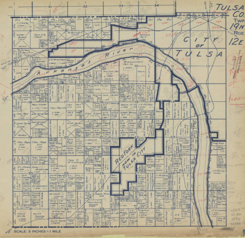
During the Great Depression, the Federal Works Progress Administration (WPA) and Oklahoma Tax Commission (OTC) commissioned a series of maps in 1936 to document land ownership and taxable value. An example of the maps are shown above. Each map covers a Public Land Survey System (PLSS) township (6 miles by 6 miles, divided into 36 square-mile sections). Approximately 2,300 maps cover the entire state.
Municipalities are marked with heavy shaded boundaries; note that Turley, Dawson, and Alsuma are all still independent, while Red Fork had been recently annexed by Tulsa. Tax-exempt properties are marked with a diagonal cross; if the listed owner is a person's name, it's likely a tribal allotment. If taxable, two numbers are listed: L (land value) and I (improvements value). Areas without valuation may be platted subdivisions -- I notice a bunch of them along US 66 in east Tulsa: Glenhaven, Plain View Heights, Radio Heights, Romoland, Lynn Lane Drive, Indian Hills. Interesting to see some prominent names -- Kennedy and Gilcrease in SE Osage County, L. S. Robson and C. S. Avery in what's now east Tulsa, Waite Phillips around Southern Hills, Charles Page and the Sand Springs Home around Sand Springs, Mullendore in Osage and Washington counties.
Some of the Tulsa County maps include part of Osage County. The township, range, and section grid for the Osage Reservation is offset from the rest of the state. It is shifted about 1/4 mile south and 1/2 mile east of the rest of the state.
On maps of T19N townships, there is a heavy-dashed east-west line about 1/8 mile south and parallel to the N edge of the boundary. This is the Creek/Cherokee boundary, which continues west as the Osage/Creek boundary and then the southern boundary of the Cherokee Outlet. East of Lewis Ave in Tulsa this line is Admiral Place, while Archer Ave is the section and township line. You may have noticed that it's farther from Pine to Admiral than from Admiral to 11th Street -- that's why.
Browsing through one of the Osage County maps, covering an area west of Hominy that included Boston Pool, I discovered the location of 200 acres of land that my great-grandfather had owned in 1936, which led me to do more research at the Osage County Clerk's office back in February 2017.
The Tulsa County General Highway Map, Sheet 2, from 1937, shows Tulsa, Sand Springs, Turley, Dawson, and Red Fork, T20N R12E, T19N R11E, T19N R12E, which will provide some context for the WPA maps.
OSU's Oklahoma Digital Map Collection has the entire collection of WPA land maps for Oklahoma online.
BREAKING: After typing up this entry, I just discovered that someone has created a interactive, georeferenced mosaic of all the Oklahoma WPA maps, which also allows you to download maps of interest. This will be useful for locating lost and drowned municipalities, like Keystone, Antwine, Lugert, Centralia, and Hochatown. You can adjust the transparency of the WPA maps, allowing you to overlay it on a present-day satellite view.
Here are the Tulsa County maps, starting at the north end of the county and working west to east in rows.
- T22N R12E (126th St N to 186th St N; 81st West Ave to Peoria, far north Tulsa County and part of Osage County around Skiatook)
- T22N R13E (126th St N to 186th St N; Peoria to Mingo, far north Tulsa County between Skiatook and Collinsville)
- T22N R14E (126th St N to 186th St N; Mingo to 193rd East Ave, far north Tulsa County around Collinsville)
- T21N R12E (66th St N to 126th St N; 81st St West to Peoria; Sperry and vicinity)
- T21N R13E (66th St N to 126th St N; Peoria to Mingo; between Sperry and Owasso)
- T21N R14E (66th St N to 126th St N; Mingo to 193rd East Ave; Owasso and vicinity)
- T20N R12E (Archer to 66th St N; 81st West Ave to Peoria; southeast Osage County, north Tulsa, Turley)
- T20N R13E (Archer to 66th St N; Peoria to Mingo; north Tulsa, Dawson, Mohawk Park, airport)
- T20N R14E (Archer to 66th St N; Mingo to 193rd East Ave; northeast Tulsa)
- T19N R10E (Edison to 61st St S; 273rd West Ave to 177th West Ave; far west Tulsa County)
- T19N R11E (Edison to 61st St S; 177th West Ave to 81st West Ave; Sand Springs, Prattville, and vicinity)
- T19N R12E (Edison to 61st St S; 81st West Ave to Peoria; west Tulsa, Red Fork, Sand Springs, Berryhill; heavy dashed line is the Cherokee/Creek & Osage/Creek boundary)
- T19N R13E (Archer to 61st St S; Peoria to Mingo; midtown Tulsa; heavy dashed line is the Cherokee/Creek boundary at Admiral Place)
- T19N R14E (Archer to 61st St S; Mingo to 193rd East Ave; east Tulsa; heavy dashed line is the Cherokee/Creek boundary at Admiral Place)
- T18N R12E (61st St S to 121 St S; 33rd West Ave to Peoria; southwest Tulsa in Jenks school district, west Jenks)
- T18N R13E (61st St S to 121 St S; Peoria to Mingo; Jenks, south Tulsa, north Bixby)
- T18N R14E (61st St S to 121 St S; Mingo to 193rd East Ave; Broken Arrow, Union and vicinity)
- T17N R12E (121st St S to 181 St S; 33rd West Ave to Peoria; Glenpool and vicinity)
- T17N R13E (121st St S to 181 St S; Peoria to Mingo; Bixby and vicinity)
- T17N R14E (121st St S to 181 St S; Mingo to 193rd East Ave; Wealaka (Leonard) and vicinity, south Broken Arrow)
- T16N R12E (181st St S to 241 St S; 81st West Ave to Peoria; south Tulsa County, north Okmulgee County)
- T16N R13E (181st St S to 241 St S; Peoria to Mingo; south Tulsa County, north Okmulgee County)
- T16N R14E (181st St S to 241 St S; Mingo to 193rd East Ave; south Tulsa County, north Okmulgee County)
0 TrackBacks
Listed below are links to blogs that reference this entry: 1936 Tulsa County WPA Maps.
TrackBack URL for this entry: https://www.batesline.com/cgi-bin/mt/mt-tb.cgi/8823