Tulsa in the 1920 Official Automobile Blue Book
Before Eisenhower's Interstate Highway System, before state highway officials collaborated to create a national highway numbering system in 1926, motorists traveling cross-country followed turn-by-turn directions contained in the Official Automobile Blue Book. These books are a time capsule of transportation history, not only mentioning routes, but road conditions, locations of hotels, garages, train stations, and trolley tracks.
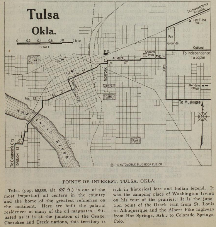
Above is a map of Tulsa from the Official Automobile Blue Book, 1920 edition, Volume 7, p. 779. That link will lead you to the page that begins the Route 901, 126.9 miles from 2nd & Main in Tulsa to Robinson & Main in Oklahoma City.
Only the streets that matter for inter-city motoring are labeled. The reset have to be inferred from old maps.
Heading east, the route goes down 2nd, but bends left at Kenosha onto 1st Place, and then joins 1st Street at Lansing Ave. Two blocks east at Norfolk (misspelled as Norfork) it jogs north to Admiral Blvd, which is today the north service road for I-244. Admiral Blvd jogs north at Utica, and the route reaches Whittier Square at Lewis, where it forks three ways.
- To Independence and Joplin: North on Lewis, east on Dawson Road.
- Optional to Independence and Joplin: North on Lewis, east on Archer Street
- To Muskogee: South on Lewis, east on 11th Street.
The route to Oklahoma City turns south at 2nd and Boulder, west at 5th Street, which merges into 7th west of Houston Avenue. The route turns south onto Maybelle Ave to 11th Street, then diagonally southwest across the Arkansas River bridge -- this part of the route was obliterated for the SW Inner Dispersal Loop interchange. On the west side of the river, the map shows the route heading south on Quanah to 17th, west to a road that follows the east side of the Frisco tracks to 19th, then west on 19th to Union Ave (labeled Division Street on this map). It looks to me like the mapmaker misidentified Union as Division; the 1920 census enumeration district map shows present-day Quanah Ave was West Tulsa's Division Street, before the annexed town's street names were normalized with Tulsa's, so in all likelihood, the route followed Quanah south, then Southwest Boulevard, then Old Sapulpa Road through Oakhurst and Bowden, into Sapulpa on Mission Street and Dewey Ave, then following the old Ozark Trail / Route 66 alignment that parallels and passes under the Frisco tracks.
The trolleys mentioned in the turn-by-turn route instructions are the Tulsa Street Railway (specifically the 5th Street track and the car barns at 5th/7th & Lawton) and the Sapulpa & Interurban, aka Oklahoma Union Traction, with an interurban line crossing the Arkansas River at West Tulsa and city streetcar lines in Sapulpa.
The Tulsa map shows SL&SF (Frisco -- SW to NE), AT&SF (Santa Fe -- SW to N), MKT (Katy - W to SE), and Midland Valley (N to S) railroads, but we can only infer electric interurban lines from mentions in the turn-by-turn text. These railroad stations are shown but Midland Valley is absent:
- MKT at Main between Cameron & Easton.
- SL&SF/ATS&F at Boston south of the Frisco tracks (to be replaced by Union Station)
- West Tulsa station south of what would be 18th & Santa Fe, west of the tracks
- East Tulsa Frisco station at about Delaware Ave, south of the Frisco tracks
Civic amenities shown include Oaklawn Cemetery, Owen Park, Central (Centennial) Park, and Swan Lake Park, but only Admiral Park is named. Kendall College (now University of Tulsa) is misspelled as Kendale, but shown as a couple of buildings east of College Ave between 5th and 7th. The Fair Grounds were between Archer St and the Frisco tracks, from Lewis to about Archer Place. The near northside is hidden beneath the title and scale on the upper left, but deep Greenwood Ave is not hidden. A Post Office is shown on the east side of Madison just north of the Frisco tracks, which seems strange, as that location is isolated from the center of town.
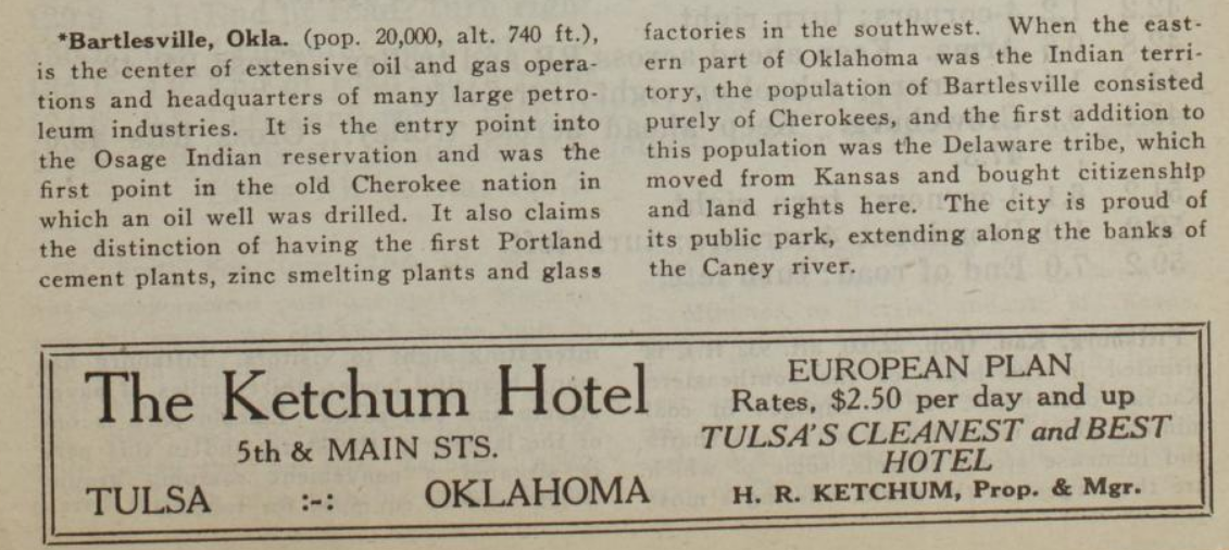
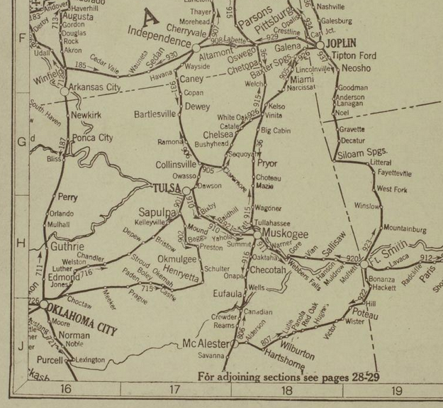
Route 902 is a longer route to Oklahoma City, 168.4 miles via Okmulgee and Henryetta, but it avoids Creek County oilfield traffic. Route 905 takes the Ozark Trail from Tulsa to Joplin, but you go through Owasso, where there was an Ozark Trail monument, to get to Claremore. Route 906 links Tulsa with Bartlesville and Independence, Kansas, paralleling present day US 75. Route 910 goes from Tulsa through Bixby to Muskogee. Each route has its reverse: Route 931 heads back from Independence to Tulsa, concluding with a description of Bartlesville and an ad for the Ketchum Hotel at 5th & Main in Tulsa.
MORE:
Hathi Trust partial collection of Automobile Blue Book volumes
1919 Official Automobile Blue Book, Volume 7, Tulsa map. In this edition, there is no route description for Tulsa to OKC via Stroud, but the road is depicted on the overview map.
"The Official Automobile Blue Book, 1901-1929: Precursor to the American Road Map," John T. Bauer (Department of Sociology, Geography, and Earth Science, University of Nebraska at Kearney), Cartographic Perspectives (Number 62, Winter 2009): Includes a list of all known editions with a breakdown by volume -- very helpful for finding the volume of interest in the Internet Archive and other online libraries.
RELATED:
Automobile Club of Southern California's beautiful strip maps of the National Old Trails Road from Los Angeles to Kansas City, with branches to Denver, Cheyenne, Big Springs, Nebraska, and the Grand Canyon. The stretch from Las Vegas, NM, to Los Angeles was the starting point for US 66 in 1926.
The National Old Trails Road: The great historic highway of America, a brief resume of the principal events connected with the rebuilding of the old Cumberland--now the National old trails road--from Washington and Baltimore to Los Angeles: A 1926 book with lots of interesting history about the evolution of named and numbered highway systems, beginning with the National Road from Cumberland, Maryland, to Vandalia, Illinois. Includes an unsuccessful 1913 congressional proposal detailing 18 numbered highways that would be improved with money from a new federal tobacco tax. Roads 11 and 13 would pass through Muskogee and Oklahoma City, but Tulsa doesn't get a mention. Also much discussion about the proper and constitutional role of the federal government in road building.
0 TrackBacks
Listed below are links to blogs that reference this entry: Tulsa in the 1920 Official Automobile Blue Book.
TrackBack URL for this entry: https://www.batesline.com/cgi-bin/mt/mt-tb.cgi/8911