Maps: January 2011 Archives
The Oklahoma House of Representatives will hold a session of its "Redistricting Listening Tour" in the Career Services Center auditorium of Tulsa Technology Center's Lemley Campus, 3420 S. Memorial, Tuesday, Jan. 25, 2011, at 7 p.m.
I hope to attend. Redistricting is a favorite topic -- it combines maps, math, and politics -- and it deals with fairness in representative government. My first published guest opinion was a May 31, 1991, Tulsa Tribune "Point of View" piece on redistricting: "Those Districts Belong to Us."
Although the population has shifted and the lines have been redrawn once in the subsequent score of years, the problem I described and the principles that should guide redistricting still hold true. I hope the first Oklahoma redistricting with my fellow Republicans fully in control will be the epitome of fairness and common sense. If Republicans could win a supermajority of seats in both houses despite the 2001 district lines drawn by Democrats to preserve their own power, the GOP can certainly hold the legislature with fairly drawn districts that reflect communities of interest rather than incumbent self-interest.
While I may not be able to persuade my friends in the legislature to draw fair lines, I hope at least that I can persuade the House and Senate to use common lines, as much as possible, to avoid some of the absurdities that emerged from the 2001 redistricting.
Meet Precinct 184.
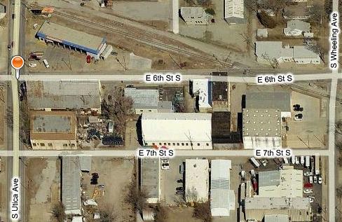
This uninhabited precinct, home of Marshall Brewing Company (which didn't exist when the lines were drawn), is bounded by 6th and 7th Streets, Utica and Wheeling Avenues. In 2000, the Census Bureau defined it as tract 23, blocks 1064 (west of the tracks) and 1047 (east of the tracks).
It exists as a separate precinct because it is the only area that is in both Senate District 11 and House District 72. North of 6th St. is in SD 11 and HD 73. East of Wheeling and south of 7th is SD 33 and HD 72. West of Utica is SD 11 and HD 66.
State law (26 O.S. 3-116 A) requires that "The boundary line of any precinct shall not cross the boundary line of any district court judicial district electoral division or any congressional, legislative or county commissioner district." Had this block been included in the same precinct as one of its neighbors, this law would have been violated. Without this law, you might have voters in a single precinct voting in two different House or Senate districts, sending two different ballot versions into the same ballot scanner.
The lack of collaboration between House and Senate on boundaries forced the Tulsa County Election Board to create this unnecessary precinct and at least four others, two of which are uninhabited.
Precinct 187 (Tulsa County 2000 census tract 46, block 1994) is a triangle bounded by the eastbound and westbound lanes of I-244 between the west bank and the centerline of the Arkansas River. Formerly a part of precinct 801, it is the only sliver of land (sand, more truthfully) in both HD 66 and SD 37.
Precinct 185 is Tulsa County 2000 census tract 76.10, block 1015, bounded by Riverside Drive, the east bank of the Arkansas River, Joe Creek, and a bike path (roughly the continuation of Trenton Ave.) It is the only census block in both SD 37 and HD 69.
Precincts 179 and 180, near 76th St between Yale and Sheridan, have a few voters each. They exist because the House chose the east-west center line of the section as a boundary between HD 67 and HD 79, while the Senate chose a series of streets that cut across the square mile -- 76th St, Erie Ave, and 77th St -- to divide SD 25 from SD 39.
There very nearly were more microprecincts. House and Senate mapmakers differed over whether the westbound or the eastbound lanes of the Broken Arrow expressway between Harvard and Pittsburg should form a district boundary. But it appears that this narrow strip of land, tract 39, block 4001, in HD 71 and SD 33, was attached to precinct 71, just to the west.
Mercifully, Oklahoma law allows the creation of "subprecincts" in such cases. A subprecinct can share precinct judges and a polling place with a neighboring precinct, but it still must have its own ballot box. Depending on which races are contested, it may require its own ballot to cover its unique combination of districts.
How did this happen? Each chamber of the legislature worked separately on its own plan, without reference to the Other Body, defining districts in terms of U. S. Census Bureau census blocks, rather than in terms of boundary lines. Wherever there's a street, a stream, a railroad, or a political boundary, there are separate census blocks on either side. The Census Bureau provides a database with population counts by census blocks, and each house divvies up counties, census tracts, and census blocks in order to produce contiguous districts of roughly equal population.
Rather than repeat the same folly, I urge our legislature to use common boundaries to define House, Senate, and Congressional districts. Since the federal courts tossed aside our constitutional provisions on legislative apportionment back in 1964, the number of legislators in each house has been defined by statute.
So let's add two senators to make 50, subtract one rep to make 100. Define 100 State House districts. Combine them in pairs to make 50 Senate districts. Combine 10 Senate districts into each of our five Congressional districts. Or start with Congressional districts and divide them into 10 Senate districts each, and each Senate district into two House districts.
Either way, it would make it easier for constituents to know who their legislators are, would make it harder to use district boundaries to protect incumbents, and would make it easier for county election boards to draw precinct boundaries.
MORE:
2000 Census maps of Tulsa County, showing census tracts and blocks
Tulsa County Election Board maps of precincts and districts.
Title 14, Congressional and Legislative Districts. For some reason, you can find the detailed definition of 2001 Senate districts here, but not House districts, so here is the rich-text format (Word-compatible) version of HB 1515, the 2001 Oklahoma House redistricting bill as signed by the governor.