Arkansas River: October 2006 Archives
So we've been told that the Arkansas River is far too wide to make for an intimate river walk setting. Anyone who has been to the San Antonio River Walk knows there's something to this. (On the other hand, Riverwalk Crossing in Jenks seems to be doing fine with development on one side of the river only. Ditto for your typical seaside boardwalk.) Bing Thom says you need to build the $600 million islands in the river so it'll be close enough to wave at someone on the opposite shore.
Is there another way to create a narrower water feature? Perhaps using tributaries of the Arkansas?
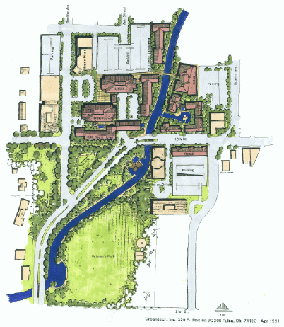
About a month ago (I've been meaning to get this posted), John Neas was kind enough to send me a concept drawing from 1991. I had heard about this, but had never seen it. There's a creek that was long ago buried and routed through storm sewers. It's called Elm Creek, and it flows, mostly underground, from Kendall-Whittier, through Central Park (6th & Peoria), south through Gunboat Park (11th to 13th, Elgin to Frankfort), to 15th & Boston, along Baltimore Ave, along the western edge of Veterans' Park, emptying into the river under the 21st Street bridge. The stretch from Central Park to Veterans' Park consists of an 84" arch tunnel.
This plan, shown in the picture above (click on it to download a higher res version in PDF format), would have brought the creek back to the surface from about 16th & Baltimore to Riverside Drive. Disregard the buildings and the street closings, and just focus on where the creek is relative to the park, the 18th & Boston district (considerably more active now than it was in 1991), and the river. It would make for an interesting connection between 18th & Boston and River Parks, providing a back door to businesses along Boston and opening the possibility for new businesses in place of the parking lot on the west side of Baltimore. Obviously the idea can be tweaked to fit the positive things that are already happening in the neighborhood.
The idea of bringing a creek to the surface as a promenade and neighborhood focal point is an important part of the Pearl District plan, which would open Elm Creek up as a canal along 7th Street to connect the new lake at Central Park with a proposed stormwater detention facility further east.
River development proposal delays actual funded river development :
[River Parks director Matt] Meyer said all of the third-penny sales tax that goes toward river improvements in the area between 11th and 21st streets will be on hold until a decision is made on The Channels.
Urban Tulsa Weekly has a bright and shiny new website!
All the links in my archive category are now broken! But it's worth it! (And they'll be easy enough to fix -- it will just take time.)
(There's a really simple forwarding trick they could do to fix all the broken links on the server side.)
Here's this week's column, part 6 in the series dealing with The Channels proposal, this week asking about the best way to create a more pedestrian-friendly city, learning a lesson from the success of a waterfront development in Florida.
This week's column in Urban Tulsa Weekly is a report and commentary on the public comment session of the Arkansas River Corridor Master Plan Advisory Committee regarding The Channels, held a week ago Tuesday, October 3, at OSU-Tulsa.
The copy editor is evidently bored with the topic, as my column was given the headline Poltergeist X. (It's actually the fifth column in a row that has had something to do with the islands-in-the-Arkansas plan.)
I, on the other hand, feel like I've found my muse again. It's not that I'm smitten by The Channels (which should be obvious), but the proposal has given me a jumping-off point to talk about many other important issues: How do we create interesting and lively urban places? What makes for walkable communities? What should we be doing to compete for population with other cities and with our own suburbs? What do we mean when we say we want river development?
I've uploaded several audio files and will be uploading more over the course of the evening, along with comments. This first group were mentioned in this week's column, so that you can hear for yourself what was said. These are all MP3 files, each less than 1 MB in size.
- Facilitator Gaylon Pinc explains the format for the evening.
- Pinc explains that answering questions would allow things to "get out of hand."
- Debbie Sanditen of changethechannels.com reads a letter of concern from the Oklahoma Floodwater Management Association.
- Richard Baldwin, a property owner along the north bank of the river west of downtown, explains the effect of high river levels on land north of the levee and on the river's tributary creeks.
- Architect Dan Hicks describes his alternative proposal for development on the west bank of the river.
- W. K. Warren, Jr., declares that Tulsa is a backwater community and says, “I don’t want to give $10 million dollars to something and hear a bunch of naysayers.â€
- Attorney Mike Redman discounts Hicks' plan because it lacks a presentation as slick as that produced for The Channels.
- Tamara Daniel touts The Channels as a cure for Oklahoma's obesity epidemic.
- Flood control expert Ron Flanagan says that we ought to handle unfunded higher-priority projects to take water out of the flood plan, rather than using tax dollars to build new land in the floodway.
- The next to last speaker, Josh Walker, describes the concerns raised at the meeting as "ignorant statements."
Also, don't miss my colleague Jamie Pierson's column, which covers the history of the relationship between Tulsa and the Arkansas, up to and including the Arkansas River Master Corridor Plan.
Tomorrow's Tuesday, so I'll be on the radio as usual at 6:10 on 1170 KFAQ with Michael DelGiorno, and I'm sure one of the topics will be the editorial and front page story in Sunday's Whirled.
I don't have them ready yet, but by late Tuesday night I plan to post a number of clips from last Tuesday's public hearing of the Arkansas River Corridor Master Plan Advisory Committee regarding The Channels, which is also the subject of my UTW column coming out this Wednesday.
One of the fascinating things about Tuesday night's public comment session regarding The Channels is how few of the people speaking were "the usual suspects" -- the sort of people who have turned out frequently in the past to comment either for or against a major tax initiative. Only a half-dozen or so of the speakers were familiar to me as people who are engaged in civic matters.
Two of the new faces belonged to Erin Johnson and Debi Sanditen, who have set up a group called Change the Channels. According to their website, the group's "goal is to examine and research questions about The Channels project, then responsibly bring forth our findings." They have a list of concerns, and they have links to related resources, including a letter from the Oklahoma Floodplain Management Association opposing The Channels
.
On the INCOG website, there is this PDF document laying out a timeline which would get The Channels ready for the Tulsa County Commissioners to put a sales tax on the ballot in December. The reason for targeting December is that Bob Dick will no longer be on the County Commission after January 1, and it's possible that Wilbert Collins will be defeated by John Smaligo in his re-election effort. They want this put on the ballot while the current commissioners, who have never met a sales tax increase they didn't like, are all still in office.
| DATE | MEETING/ACTION | LOCATION |
| September 14, 2006 | Tulsa County Commission Chairman requests Channels Plan Review by INCOG | |
| September 22, 2006 | Steering Committee briefing on Channels Project | INCOG Conference Center, 201 W. 5th St.; 2:00 p.m. |
| no date listed | Advisory Committee briefing on Channels Project | Aaronson Auditorium, Tulsa Central Library |
| September 25, 2006 - October 13, 2006 | Working Groups conduct technical review of proposed Channels project by functional area | TBD |
| October 3, 2006 | Advisory Committee public hearing on Channels project | OSU Tulsa , Auditorium, North Hall Conference Center; 6:00 - 8:00 p.m. |
| October 12, 2006 | INCOG Board briefing on Channels project | Lecture Room, Tulsa Central Library |
| October 17, 2006 (week of) | Advisory Committee reviews Working Groups functional reports and formulates comments on proposed Channels project | TBD |
| no date listed | Steering Committee reviews Advisory Committee comments and formulates recommendation to INCOG Board and Tulsa County Commission | TBD |
| October 18, 2006 | Planning Commission (TMAPC) briefing on Channels project | Francis Campbell Meeting Room |
| November 1, 2006 | TMAPC Public Hearing on proposed Channels project and possible Comprehensive Plan amendment | Francis Campbell Meeting Room |
| November 9, 2006 | INCOG Board considers approval of possible River Corridor Plan amendment to include Channels project and implementation strategies including other River projects | Aaronson Auditorium, Tulsa Central Library |
| November 15, 2006 | TMAPC considers possible resolution recognizing Channels project as a part of amended Arkansas River Corridor Master Plan and Comprehensive Plan | Francis Campbell Meeting Room; 1:30 p.m. |
| November 21, 2006 | Tulsa Stormwater Advisory Board briefing on Channels project | Tulsa City Hall; 11th floor: 3:00 p.m.; |
| November 29, 2006 | TMAPC approves minutes of November 15, 2006 meeting and transmits possible resolution to Tulsa City Council for approval | Francis Campbell Meeting Room; 1:30 p.m. |
| December 5, 2006 | Tulsa City Council (committee) presentation of Channels project and possible TMAPC resolution | Tulsa City Council Meeting Room |
| December 7, 2006 | Tulsa City Council considers approval of possible TMAPC resolution recognizing an amended River Corridor Plan including the Channels as a part of the Comprehensive Plan | Francis Campbell Meeting Room |
| December 11, 2006 | Tulsa County Board of County Commissioners considers approval of possible TMAPC resolution recognizing an amended River Corridor Plan including the Channels as a part of the Comprehensive Plan | Tulsa County Commission Meeting Room |
Except for the no date listed notations, the table above is as it appears in the linked PDF document.
It's unclear how much of the current phase of the process is going to be accessible to the public. Evidently Tuesday night was our chance to speak up for the benefit of the Arkansas River Corridor Master Plan Advisory Committee, although I haven't seen a list of members of that committee, and I don't know how many of them were in attendance Tuesday, other than Don Walker of Arvest Bank and mayoral aide Susan Neal, who each recognized as leaders of the committee. Then there is some sort of steering committee. If this process is to have the transparency which has been promised, the public needs to know who sits on these committees, and where and when they will meet.
In the previous issue of Urban Tulsa Weekly, I wrote that when Tulsans say they want river development, they are really seeking a lively promenade, a place to see people and to be seen. This week, I propose a way to make that kind of bustling promenade happen along the banks of the river between 11th and 21st Street, working within the existing river master plan.
I'd be very interested in your comments on this concept, and to that end I've started this thread over at The Voice of Tulsa forum.
The Fijian island of Vatu Vara is being offered for sale by Coldwell Banker Morrisons Private Islands. Also known as “Hat Island†after the 1,000-foot-high round mesa that dominates the center of the island, it’s described as “The Most Beautiful and Expensive Private Island in the World.†It’s about 2 miles across – about 4,000 acres in size, a hundred times bigger than the proposed archipelago in the Arkansas River.
The price tag: A mere $75,000,000, a tenth of The Channels’ $788 million cost. In fact, for the price of The Channels, you could buy the 100 most expensive islands offered for sale on www.luxuryrealestate.com and still have about $58,000,000 in change.
(Sandy Cay, in the Bahamas, the private island owned by the owners of Tulsa’s monopoly daily newspaper, is a bargain at a mere $2,675,000.)
This is the originally submitted version of a story that was published on October 4, 2006, in the October 5-11, 2006, edition of Urban Tulsa Weekly. The story as published can be found at the Internet Archive. Posted on BatesLine on March 23, 2016.
A promenade on the river
By Michael D. Bates
Last week we asked the question, "What are Tulsans really after when they say they want river development?" The answer is a lively public place, the sort of thing we've seen along the river in San Antonio or along the canal in Oklahoma City's Bricktown. We can see it closer to home, at Riverwalk Crossing in Jenks, where the chance to be in a place bustling with people is a draw regardless of the amount of water in the river.
We want a place where a short stroll takes you past a variety of activities and a variety of people. This kind of place has a name: A promenade.
The book A Pattern Language: Towns, Buildings, Construction, provides this description:
"The promenade, 'paseo,' 'passegiata,' evening stroll, is common in the small towns of Italy, Spain, Mexico, Greece, Yugoslavia, Sicily, and South America. People go there to walk up and down, to meet their friends, to stare at strangers, and to let strangers stare at them.
"Throughout history there have been places in the city where people who shared a set of values could go to get in touch with each other. These places have always been like street theaters: They invite people to watch others, to stroll and browse, and to loiter...."
The human impulse still manifests itself, even in Oklahoma's car-dependent culture. Small-town teens cruise Main Street on a Friday night, while suburban teens gather at the mall not just to shop, but to connect with friends. Elements of the promenade pattern can be found in Tulsa's older neighborhood commercial areas, places like Cherry Street and Brookside and 18th and Boston, where it's possible to walk from your house to a neighborhood coffee shop or pub or restaurant.
I believe we can create this sort of place along the banks of the river. We can do it in accordance with the existing Arkansas River Corridor Master Plan. We can do it without sacrificing the natural qualities of the river. We can do it without raising taxes by $600 million.
The east bank between the 11th and 21st Street bridges may provide the best opportunity for creating that kind of place along Tulsa's stretch of the river.
One of the elements of a successful promenade is a concentration of people within a 10 or 15 minute walk -- close enough to be a realistic destination for an evening stroll. The neighboring area is one of the more densely settled parts of Tulsa: a historic neighborhood of single-family homes, several high-rise apartment and condominium buildings, and a number of low-rise apartment and condo complexes. It's within walking distance of the convention center and could be an amenity for out-of-town visitors as well.
It's also a convenient drive-to destination. The major commuter route along Riverside and Denver passes right by, making it an easy place to stop before heading home to south Tulsa. It's close to the hub of Tulsa's expressway network. At the same time, the two-lane continuation of Riverside north of Denver means that the park isn't cut off from the neighborhood.
(It also isn't cut off from the rest of the city by a 300-foot-wide moat, which means that people won't feel compelled to drive to get there.)
But convenience isn't sufficient to make a place work as a promenade. A Pattern Language observes that it must provide people with some sort of destination, "for example, clusters of eating places and small shops," and the centers of activity must be close enough together - they reckon no more than 150 feet apart - to prevent desolate and dead spots on the path. There needs to be a series of interesting places, each close enough to the next one to entice you a little further down the path. Finally, a promenade needs significant points of attraction at both ends to act as anchors.
The Arkansas River Master Corridor Plan calls for building a "promenade" - a kind of boardwalk - along the east bank between 11th and 21st. An expanded café near Riverside and Denver would act as the south anchor and the planned Route 66 museum and restaurant will provide an anchor for the north end of the site. There's already public money committed for improvements in this area - $5.25 million in the 2006 third-penny sales tax plan for the park, plus Vision 2025 money for the Route 66 facility.
What's missing is the in-between stuff. The space needs to be more commercial than it is, but not so developed that the natural beauty of the river is obscured or that joggers, dog walkers, and cyclists feel unwelcome.
Bryant Park in Manhattan is a good example of balancing the natural and the man-made in an outdoor public space. Although the context is different, many of the same amenities would work well here.
Like Bryant Park, this park should have free WiFi (to allow some people to do their work in the park), several food kiosks (at least one serving good coffee), and well-maintained restrooms. There ought to be chairs you can move, so you can choose to sit in the sun or the shade. It ought to be a place you could comfortably spend the whole day.
In Bryant Park, the public library has a small reading "room" - really an outdoor area - with novels and magazines and newspapers available to read. Another part of the park has tables for playing games - you can rent chess and backgammon sets. We could do something similar here.
There ought to be a couple of places to rent bicycles and rollerblades, and some place where you can buy sunscreen and bug spray in case you forgot yours at home. A carousel would be a summer-evening attraction, perhaps along with one or two other small, relatively quiet kiddie rides.
The actual mix of activities and amenities could change over time as we observe what attracts people and what doesn't. The kiosks and other permanent facilities should be flexible in their design. But they should be spread along the length of the park, with a major cluster of activity about halfway along, perhaps near Riverside and Galveston.
The area would be further enhanced by neighborhood-friendly mixed-use redevelopment along the east side of Riverside Drive between Galveston and Denver.
We shouldn't force it, but we should allow those aging apartment complexes, built in the '60s and '70s, to be replaced with well-built three- and four-story buildings which front the sidewalk with retail space on the ground floor, office space and apartments above, and maybe restaurants with roof gardens on the top floor, to take advantage of the view.
In the process of redeveloping that stretch, we should improve the connections between the neighborhood and the park, adding public stairways from Riverside up to streets like Elwood and Frisco that dead-end on top of the hill. Perhaps there could be a grand staircase connecting the Sophian Plaza building, done in the same majestic style as that landmark structure, leading to a major focal point of the park, like a sculpture fountain or the carousel.
This park isn't going to be the blockbuster destination that makes the world stand up and notice Tulsa. Indeed, no single project in one place, no matter how extravagant, will fix what ails our city.
Instead, we need to repair and enhance the urban fabric and the quality of life throughout the city. This park would be a model as we create pleasant and safe gathering places throughout the city, even the farthest reaches of north, east, south, and west Tulsa. At the same time, we need to take care of the basics - preventing crime, maintaining our streets, providing good schools.
That kind of steady and comprehensive strategy, not a desperate billion-dollar gamble, will make our city more beautiful and more attractive as a place to live, work, and visit.
If you'd like to talk more about this approach to river development, I invite you to visit thevoiceoftulsa.com, my favorite online discussion forum about local issues.
You'll have a chance tonight to voice your opinions about "The Channels" to the Arkansas River Corridor Master Plan Advisory Committee. Here's the press release:
NEWS RELEASE Public Hearing for Arkansas River Channels Project to be held Oct. 3
The Arkansas River Corridor Master Plan Advisory Committee will host a public hearing to receive comments on the Arkansas River “Channels†project proposed by the Tulsa Stakeholders Inc (TSI).
The hearing will be held from 6 p.m. to 8 p.m., on Tuesday, Oct. 3, in the Auditorium in the North Hall Conference Center at the OSU Tulsa campus.
TSI will make a brief presentation on the “Channels†project at the beginning of the hearing. The primary purpose of the hearing is to elicit input from the public regarding the proposed Channels projects.
The Tulsa County Commissioners have asked the Arkansas River Corridor Master Plan Advisory Committee to review the “Channels†project.
The Advisory Committee guided development of the Arkansas River Corridor Master Plan, which has been recognized as part of the Tulsa Metropolitan Area Comprehensive Plan and was adopted by the Tulsa Metropolitan Area Planning Commission, the Tulsa City Council, and the Tulsa County Board of Commissioners.
-30-
And here's a link to the Arkansas River Corridor Master Plan.
Last week's Jenks Journal has an interview with Brent Gordon, an Oklahoma Wildlife Department biologist based in Jenks, about the tremendous amount of rubbish and debris in the Arkansas River:
Gordon says he would like to see someone get concerned about other things in the river - junk - everything from Wal-Mart shopping carts to remnants of yesteryear's visionaries....Gordon says he has not seen any thing in the paper work nor has he heard any discussion about what is to become of the huge pieces of metal, mounds of steel cable, overall trash, shopping carts and steel pipes so prevalent in the river.
"Are we just going to flood the river over this stuff," he questions.
A call to Wal-Mart about the carts only brings a shrug. Who can prevent people from pushing the carts off the side of the nearby drainage ditch where the next downpour will deposit them into the river. The Wal-Mart logos on the handles are still visible on some of the carts. Others, as many as two dozen are all but buried in the sand.
Less likely to disappear, except by raising the water level are huge amounts of what looks like old oilfield and construction equipment. Pipes are everywhere, some protruding vertical from the river bed and bubbling.
A huge, broken barge or perhaps the remnants of Jenks old ferry system rests near bank erosion and other junk at the bank at the north side of the RiverWalk development. Except where old concrete, brick and building parts have been dumped, high dollar real estate is gully washing into the river.
On the TulsaNow forum, Steve Smith, who used to run airboat tours on the Arkansas, comments:
I have made note to anyone who cares to listen of the debris scattered along the river. No one has really cared. Since the river has been invisible to passing traffic it suffers from "out of sight-out of mind". It is particularly bad under the bridges where old bridge structures were just pushed into the river making for future difficulty in navagation. That is a state responsibility.Some may find it hard to believe, but it gets worse the farther downstream you go. Jenks debris is much more visible because of the lower water levels and increased populations in that area. Lighting their pedestrian bridge really shows off the trash. Much of it is oilfield equipment but equally to blame are sand dredging companies. Oil company cleanups that are advertised on TV restoring Blue Bird camps need to spend some of that money reclaiming the pipelines and driiling equipment they left in the river. Sand dredging companies need to follow suit and the state needs to hold contractors liable.