Arkansas River: January 2007 Archives
The big story I've been working on is finally in print. This week's Urban Tulsa Weekly cover story is the epic tale of a century -- yes, a century -- of Tulsa's plans to do something interesting with the Arkansas River.
This story was a blast to research. UTW's Holly Wall and Siara Jacobs rounded up copies of articles and documents from the 1968 and 1976 plans from the very helpful folks at the River Parks Authority. I spent hours paging through Central Library's "vertical files" and repository of old planning documents. I had far more material than I could use. I was helped immensely by a conversation with architect Rex Ball, whose firm developed the 1968 River Lakes Park plan, and by my long acquaintance with Jim Hewgley III, who was Streets Commissioner when the Zink Lake low-water dam was built by Mayor Jim Inhofe.
It's my intention to scan and upload much of the research material and to provide some sort of bibliography to help anyone else who might want to do further research.
In the story I mention a river concept presented very briefly in a 1959 document called A Plan for Central Tulsa:
A page of that study was devoted to "The Marina," a concept for the river between 11th and 21st Streets. The accompanying illustration showed an artificial lagoon for boats near 15th and Riverside, a floating restaurant and boat club just to the south, a "picnic island" accessible by pedestrian bridge just to the north, and a larger island, accessible only by boat, where the west bank used to be.Yes, used to be. The drawing showed the river almost twice as wide as its existing width at the 21st Street bridge, backed up by a dam at some unspecified location downstream, with the new shoreline just below the west bank levee. The resemblance to last year's "The Channels" plan is uncanny.
I took a photograph of the illustration so you can see for yourself. It's not as sharp as I'd like, but I think you can make it out. Click on the image to see it in its original size.
(Notice that in 1959, the location of the Inner Dispersal Loop, seen along the top of the diagram, has already been determined, although it wouldn't be completed until nearly 25 years later.)
My column this week is also about Tulsa history:
Oklahoma's centennial year ought to be a year when all Oklahomans -- natives and newcomers alike -- encounter our state's history in a way that engages our imaginations. While every year is a good year to study Oklahoma history, this is a year that ought to be hallowed to that purpose, a year for remembering where we came from and how we got to where we are today.
The June unearthing of the buried Belvedere fulfills that purpose quite well. I propose extending that glimpse back 50 years with the Tulsa 1957 project, which I launched here a while back and explain in detail in the column. I also mention a couple of websites which are helping to capture everyday life in Tulsa as it was. (But I neglected to mention Jack Frank's wonderful Tulsa Films series, which uses TV footage and home movies to bring decades past back to life.)
Also this week UTW gives a rave review to the source of the coffee and quesadillas that helped fuel my 6,000-word feature story. Katharine Kelly gives the Coffee House on Cherry Street five stars each for food, atmosphere, and service.
RELATED: A pretty thorough outline history of the Arkansas River in the Tulsa area.
This is the originally submitted version of a story that was published on January 31, 2007 as the cover story of the February 1-7, 2007, edition of Urban Tulsa Weekly, under the headline "The River Review: Planning Tulsa's Riverfront: A Brief History." The story as published can be found on the Internet Archive. Posted on BatesLine on March 23, 2016.
Planning Tulsa's Riverfront: A Brief History
By Michael D. Bates
The 12-year-old boy with a map fixation was entranced by the two-page-spread in the January 1976, edition of Tulsa magazine.
A stretched oval of water, held back by something called a "low water sill" was fringed top and bottom by belts of green. There were bicycle paths, ferry docks, an amphitheatre, a museum, restaurants. Best of all, there was a planetarium.
The article began with an imaginary conversation between a dad and his son, talking about their family's plans for a day on the river: Fishing, canoeing, archery, shopping, dinner at the floating restaurant - a fun-filled day capped by a concert at the amphitheatre, with a 150-foot-high lighted fountain providing a picture-perfect backdrop.
"If things go as planned," the article promised, "similar conversations will take place in and about Tulsa beginning as early as 1978.
The boy (the real one, not the imaginary one in the magazine story) flipped through the pages of the article. He scanned over words like "silt," "planning workshop," "contaminants," and "Urban Renewal funds" to get to the rest of the illustrations. There was the plan for the 21st Street Bridge, with nearby overlook and ferry landing. There were sailboats moored at a marina, down the bank from a gallery of shops. There was a cross-section of the museum and planetarium building:
"Portraying the natural and economic history of Tulsa, a museum will highlight the petroleum and transportation industries. A moderately priced restaurant will be incorporated in the upper floor to take maximum advantage of the river view. The planetarium will offer programs of the astronomical sciences, with emphasis on the aerospace industry."
It was already fun to ride bikes on the trails that were especially for bikes - he had thought that was a cool idea ever since he cajoled his parents into taking him to the Gilcrease Hills grand opening six or seven years before. Already you could even ride your bike halfway over the river on an old railroad bridge. But this plan - the "River Parks plan" - was going to be amazing when it was all finished in just a few years.
31 years later, that boy has a boy of his own, about the same age, and the 1976 River Parks plan, focusing on a two-mile long lake, has been superseded by an Arkansas River Corridor Master Plan, taking in the entire 42-mile length of the river through Tulsa County. And for a brief time last year, it seemed that a good third of that brand new plan would be wiped away by an even newer plan - The Channels - for a 12-mile-long lake and three high-rise-encrusted islands in the middle of the river.
The River Parks plan wasn't the first plan, and The Channels certainly won't be the last. For almost as long as there has been some sort of settlement near this bend of the Arkansas, there have been dreams of making the river more than the shallow, salty stream that it naturally is.
In 1962, Tulsa World Sunday editor Russell Gideon wrote, "The plus-and-minus values of the Arkansas River, so far as Tulsans are concerned, probably have added up to a whacking big minus figure over the 80 years of the town's existence."
Gideon enumerated the minuses of the river in the early days of Tulsa: It was an obstacle to travel, its water was unfit for drinking or even bathing, it flooded, it smelled from being used as a sewer, it attracted "shanty-boat dwellers" (Tent City on the water, evidently), it was "a source of worry to mothers of venturesome boys." Even when dry it was a nuisance: "During the dust bowl days the river bed contributed its share to the 'black blizzards' of the era."
Accordingly, Tulsa turned its back on the river, aligning itself instead with the railroad that was its lifeline to the outside world. Tulsa abandoned it as a source of water, built bridges across it, and piped sewage into it, but otherwise left it to its own devices.
Factories and refineries found it useful as a source of water for cooling equipment and a handy place to dump industrial waste. Views of the river were desirable, but not close-up views or the accompanying close-up smells. Oil barons like Josh Cosden and Harry Sinclair built mansions well up the hill from the river's bank.
Early hopes for improving the river were all about transportation, not recreation.
There had been a few successful attempts to navigate the river by steamboat in the 19th century . In 1834, the steamboat William Parsons made it all the way to the mouth of the Cimarron River (now in Keystone Lake) with supplies for Camp Arbuckle, a new Army post. In June 1878, the steamer Aunt Sally made her way from Little Rock to Arkansas City, Kansas. In July 1886 the Kansas Millers towed two barges of flour from Arkansas City to Fort Smith, Ark., but the pilot house had to be removed from the boat in order to clear the Frisco railroad bridge at Tulsa.
In 1909 , the Tulsa Democrat reported a plan to make the Arkansas River navigable from the Mississippi to the mouth of the Cimarron River (now part of Keystone Lake). It would have required a dam, a lock, and a harbor for loading at four points on the river: Little Rock, Fort Smith, Muskogee, and Tulsa. Each dam and lock was projected to cost $300,000.
The plan died a quiet death, but the idea lived on. In the 1920s , civic leaders from Oklahoma and Arkansas began to talk up the idea of Arkansas River navigation. It wasn't until 1946 that the Federal government authorized the project. Even then the two states' congressional delegations had to fight for funding a year at a time, one lock-and-dam at a time, fending off those, like Life magazine and President Eisenhower, who attacked the plan as a massive pork barrel scheme.
At long last, in 1971, the first barges arrived at the Tulsa Port of Catoosa. President Nixon arrived a few months later to formally dedicate the Kerr-McClellan Navigation System (and to mispronounce a few Indian place names - oo-LOG-uh? - in the process).
But the new barge canal bypassed the City of Tulsa, and while the port is certainly an important contributor to the local economy, there hasn't been the kind of development along its shores - New port towns! Industrial development to rival the Ohio Valley! Population growth in the millions! - that its boosters expected.
For the navigation system to work, they had to be able to control the flow of the river from upstream. That also meant the ability to prevent a catastrophic flood on the Arkansas River in Tulsa. In 1945, levees were built to protect industries and refineries in Sand Springs, west Tulsa, and along the Sand Springs Line. In 1950 Congress authorized the construction of Keystone Dam, which, it was hoped, would make the levees redundant.
Also in the late '40s, Tulsa's leaders began making plans for a US 66 bypass that would cross the Arkansas at 51st Street. Someone had the idea to build the bridge strong enough to buttress a dam big enough to create a five-mile-long lake which would reach all the way to the bend in the river near downtown. Perhaps the idea was inspired by Lake Austin in Texas, but wherever it came from, it seems to be the first appearance of the notion of using Tulsa's stretch of the Arkansas River for recreational purposes.
But the Federal government wasn't keen on providing the extra funds needed to make the bridge that sturdy, and the idea was dropped. (In 1964, the idea would re-emerge, this time using the Red Fork Expressway bridge as the buttress of a dam that would back the water up to Sand Springs.)
According to Tulsa architect Rex Ball, a mid-'60s feasibility study, prepared by his firm, retrospectively revealed some major flaws in the single-lake concept. A dam big enough to create that kind of lake would have endangered neighborhoods along Crow Creek (the brook for which Brookside is named, which enters the river near 32nd Street) and would have interfered with PSO's use of river water for their generating plant on the west bank at 36th Street. The larger dam might have raised the water table, something that wasn't found to be a problem for a series of smaller, low-water dams.
Meanwhile, the idea of a riverfront park began to take hold. In 1951, the city acquired land for a Riverside Park extending from 11th south to 51st Street, and the following year, city prisoners were working to clear underbrush, trash, and driftwood.
But the river was still not seen as an attraction or an amenity. In 1957, the chamber of commerce published Tulsa, I.T., a glossy 44-page tourism magazine aimed at visitors to Oklahoma's 1957, semi-centennial celebration. It included a driving tour ("The Tulsa Tour") of the city, and lengthy descriptions of the city's recreational attractions. The Arkansas River doesn't rate a mention. Water gets a page to itself, but only to make the point that Tulsa had plenty of it for residents and industry and had plans to get more.
If anything, the river was still a threat to life and property. The Arkansas flooded over three dozen times between 1907 and 1951. In May 1957, after a six-year respite, heavy rains upstream caused a near-record flood and forced the evacuation of part of Brookside. A flood of similar magnitude hit the city in October 1959.
Nevertheless, the idea of the river as a place for recreation continued to simmer. A September 1957 study by the Mayor's Committee on Recreation urged development of the east bank from Newblock Park to 51st Street for park use, recommending that the anticipated Riverside Expressway be built to preserve views and access to parking areas and picnic spots along the river.
The near-downtown riverfront was included in the 1959 A Plan for Central Tulsa, a document written by California architects and packed with daring new concepts in urban design. (Tulsa implemented those concepts decades later, waiting until other cities had had a chance to discover that they didn't work. How did downtown get so bollixed up? Read this book and you will understand.)
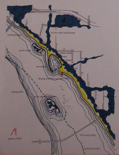
A page of that study was devoted to "The Marina," a concept for the river between 11th and 21st Streets. The accompanying illustration showed an artificial lagoon for boats near 15th and Riverside, a floating restaurant and boat club just to the south, a "picnic island" accessible by pedestrian bridge just to the north, and a larger island, accessible only by boat, where the west bank used to be.
Yes, used to be. The drawing showed the river almost twice as wide as its existing width at the 21st Street bridge, backed up by a dam at some unspecified location downstream, with the new shoreline just below the west bank levee. The resemblance to last year's "The Channels" plan is uncanny.
The plan evidently had some research behind it. Excluding the dam, construction costs were estimated at $117,300, and they projected annual revenues of $24,700, which could cover operating expenses ($8,000) and debt service ($9,300) with $7,400 left over.
The lake would accommodate boating, fishing, and water skiing. "The Marina would make living in central Tulsa the envy of every western city dweller."
In 1961, the City of Tulsa's engineering department began looking into the idea of low-water dams. Core drilling was done to test possible dam sites. A trip was made to Pennsylvania to see an inflatable "fabridam" in operation. Soon thereafter civic leaders began pitching the idea of "riverfront beautification" at meetings all over Tulsa.
By the end of 1963, a Chamber of Commerce subcommittee had designated low-water dams on the river as a priority project and set out to find funding for a detailed plan and to whip up public support for the idea.
In May 1964, things began to happen. The County and City jointly hired Hudgins, Thompson, Ball and Associates (HTB) to do a feasibility study and master plan for low-water dams. The Chamber sent a nine-member Tulsa delegation, including Street Commissioner (and future Mayor) Bob LaFortune and County Attorney (and future Governor) David Hall, to tour the Riverwalk in San Antonio, the world's largest inflatable dam in Bay City, Texas, and Town Lake in Austin, completed just four years earlier.
Austin's seven-mile lake, with its dam built into a road bridge, was described by news stories at the time as close to what Tulsa's leaders were wanting. The Tulsa Tribune recommended following Austin's lead in another important respect - establishing a plan for the kind of development desired for the waterfront and putting a commission in place to evaluate all construction permits for compliance with the plan.
The May 19, 1964, lead editorial in the Tribune enthused that the proposal would mean "a whole new pattern of commercial and civic stimulus for the very heart of Tulsa. If the pollution and planning studies make the concept feasible, there is no doubt that our turgid, smelly, desert-like waste of a river will become one of the beauty spots of the nation. And we shall find, as Texas has found, that beautification is very good business."
The "if" was a big one. A 1964 study identified 14 major sources of pollution upstream of Tulsa, including animal wastes from a packing plant, chemical effluents from refineries, oil storage facilities, and a fertilizer plant, sewage from Sand Springs. Completion of the Keystone Dam ended the heavy river flows which diluted the filth and washed it down the river. Low-water dams would only make matters worse. An April 2, 1967, Tulsa World, story on river pollution carried the subhead "Park Plans Moot."
But the planners pressed on. On April 11, 1968, the development plan for "River Lakes Park" was presented to the Tulsa Metropolitan Area Planning Commission (TMAPC), and in August it was officially added to the region's master plan.
The HTB plan called for three low-water dams to be built - near Newblock Park, just upstream from the 11th Street bridge; near 36th Street; and at the mouth of Joe Creek north of 81st Street.
(A fourth dam, to be built by the Corps of Engineers upstream of the Sand Springs bridge, was mentioned in the plan. Its purpose was re-regulation, ensuring a consistent flow of water to carry pollutants downstream, regardless of the operating schedule of Keystone Dam. This dam was actually built in 1968, but was removed in the mid '80s as a hazard and no longer needed for pollution control.)
Shadow Bluff Lake would stretch upstream from near downtown Tulsa to the Sand Springs bridge. Adams Road would be transformed into the South River Parkway, tying together an expanded Chandler Park and the south shore, which would have baseball and football fields, tennis courts, a marina and boat ramps. The shore opposite, across the levee from downtown Sand Springs, would cater to hunters, with ranges for field archery, skeet and trap shooting, and "stalking."
Further east, across the river from Chandler Park, a "Marina Market" would be located on the natural harbor formed by a creek inlet, along with a community center and tennis courts. A large sandbar near 49th West Avenue, would be transformed into an island park with an amphitheatre - and even more tennis courts. An access road would run the full six-mile length of the north shore.
Four-mile long Southside Lake would have bike trails on both shores. On the east bank, near present-day Helmerich Park, there would be an amphitheatre and tennis courts, and a small community building. Peoria would be extended north from Jenks along the west bank to a new 71st Street bridge, providing access to campsites near the dam. Turkey Mountain would be incorporated into the park system, with hiking and horse trails and a trailer campground atop the hill, with a road along the east side of the hill providing easier access to the park from north and south.
Because the planned Riverside Expressway would run right up to the edge of the river bank, the east side facilities would sit on islands built out of sand banks - mainly open space with a few small buildings for community use.
Just north of the I-44 on the west bank, the plan showed an amusement park, and an inland marina along Cherry Creek west of Elwood Ave.
The centerpiece of the plan was Tulcenter Lake. (The name originated in the aforementioned Plan for Central Tulsa.) The lake would be dammed near 36th Street. Crow Creek's outlet to the Arkansas would be the site of a canoe center and an expressway underpass linking the riverfront to Brookside. An 18-hole golf course would straddle 23rd Street on the west side, stretching from 17th Street south to the Texaco Refinery.
The east bank between 11th and 21st would include a lagoon, an oil museum and museum of natural history, more tennis courts and playgrounds, and frequent pedestrian overpasses spanning Riverside Drive.
In comparison to our most recent river plan, the 1968 plan is remarkable for its lack of commercial development. River Lakes Park was all about open space and outdoor recreation, with one notable exception.
Linking the two shores would be Pier 15, a pedestrian bridge lined with specialty shops, sidewalk cafes, theatres, and restaurants, with a view of a spectacular water display in the middle of the river. Pier 15 would connect 15th & Houston to the west bank at 17th, near the west Tulsa urban renewal area, which was originally planned for high-density residential and commercial redevelopment.
The development plan predicted that "Pier 15 could become for Tulsa what the Farmers' Market in Los Angeles or the Vieux Carre District in New Orleans have become for those cities; nationally known areas which not only serve local residents but are major features that continue to attract tourists and provide the cities with distinctive identifications."
It's a commonplace claim nowadays - "This development plan is what we need to put Tulsa on the map" - but this seems to be the first time that river development was promoted as a potential tourist magnet, not just a local amenity.
The cost estimate for full implementation of the plan, including all the amenities, was $65 million. The basic cost to get started included $8 million for dam construction, and $7.5 million for land acquisition along the lakefront.
Once the plan was presented, it was heavily promoted with speeches to civic groups, models on display at banks and libraries, and a 30-minute TV special. $16.3 million for construction of the lakes, to be funded by a property tax increase, was included in a set of 15 city bond issues on the September 9, 1969, ballot. A record turnout - described as a taxpayer's revolt - defeated 13 of the 15 propositions; the River Lakes Park bond received only 29% of the vote.
River promoters began looking for ways to get federal grants to pay for part of the plan. Some minor improvements were begun - a bike trail was started on the east shore between 31st and 51st. But for the next few years, major river development was on hold.
In September 1969, Tulsa's voters forcefully rebuffed an ambitious set of bond issues for civic improvements. They said no to the controversial plan for a Riverside Expressway and its destructive path through the Brookside and Maple Ridge neighborhoods. They said no to a new municipal auditorium at the Civic Center.
And, by a 30% to 70% margin, they said no to $16.3 million to fund the beginning of a dramatic plan for three lakes on the Arkansas River - River Lakes Park - lined with marinas, amphitheatres, tennis courts, ball fields, a golf course, campgrounds, trails, and open space. Its centerpiece would have been a 100-foot-wide shopping and entertainment center spanning the river which would become a nationally-known icon, putting Tulsa on the map.
But the idea of riverfront recreation wasn't dead. There was an ongoing effort to find federal funds to implement part of the plan. And as the city's 1973 diamond jubilee approached, there was a renewed push by Mayor Bob LaFortune to make a river project the focus of the celebration.
1973 came and went, but in April 1974, the City Commission and County Commission created the River Parks Authority (RPA), tasked in its trust indenture with "development, redevelopment, preservation and/or renewal of the ... natural resources and community resources known... as the Arkansas River Lakes Park."
At the same time, the Tulsa Urban Renewal Authority (TURA) expanded its west-bank urban renewal area to include both banks of the river between the 11th Street and the Midland Valley railroad bridges, allowing it to supply $2.8 million from the U. S. Department of Housing and Urban Development (HUD) to the RPA for riverfront park development. Work began to extend the east bank bike trail north to 11th Street.
In July 1974, the city received title to the Midland Valley bridge and began plans to convert it to bicycle and pedestrian use. The same month, Jackie Bubenik, a city planner from Lubbock, Texas, was hired as the RPA's director, and the RPA began sifting through development proposals.
Unlike the 1968 plan, this development effort would be narrowly focused on the two-mile stretch between 11th and 31st Streets. Working quickly, in August 1974 RPA selected a group headed by Memphis architect Roy Harrover, whose firm planned the development of that city's Mud Island. The hope was to have a plan in place and construction underway in a year's time. Late that year the design team hosted public workshops to find out what Tulsans wanted along the river.
The resulting plan, unveiled in the fall of 1975, called for a low-water dam south of the new pedestrian bridge to create water depth of about 6', enough to support boating and a six-stop route for passenger ferries. Near Houston Avenue, there would be a lighted mid-river fountain, shooting water 150 feet in the air. The east bank would largely remain green space, with bike paths and playgrounds. A restaurant would extend out over the river, beneath the east end of the 21st Street bridge. A wide pedestrian overpass spanning Riverside between Houston and Indian Avenues would serve as the gateway to the park, connecting to a landscaped path to downtown.
Commercial and entertainment facilities would be located on the west bank between the 11th Street bridge and the McMichael Concrete plant, anchored at the south end by an amphitheatre. (In the original plan the stage was onshore, not floating.) North of the amphitheatre along the shore would be a small marina. Above the shore would be a row of specialty shops, and a three-story museum building with a planetarium and a restaurant on the top floor. The northern end of the development area, next to the 11th Street bridge, would be reserved for a hotel.
$30.3 million was the total estimated cost for park development and all the proposed amenities. The low-water dam, thought to be the key to the whole project, would cost $3.1 million. The initial $2.8 million in federal money would be used for west bank improvements, completion of the Midland Valley pedestrian bridge all the way to the west bank of the river, and, at Denver and Riverside on the east bank, a "model park" to give Tulsans a taste of what to expect when the plan was fully implemented.
While the plans were still being planned, Tulsans actually began recreating on the river, jogging and biking on the trails and attending festivals and special events. KRMG held the first Great Raft Race on Labor Day 1973, starting a tradition that would last 19 years. The Tulsa parks department started an annual sandcastle competition. The first Oktoberfest was held on the east bank in 1979 and moved to the west side in 1981.
Before the new plan ever got off the drawing board, it began to change.
In 1979, a parks survey of county residents revealed a lack of interest in large-scale commercial and entertainment development on the river:
"Tulsans view River Parks as a place to enjoy outdoor or somewhat unstructured facilities and atmosphere, and the possibility of formal entertainment or facilities through an Amphitheater or museum is not consistent with what they view for the River Parks area."
The low-water dam was still on the table. Funding for it was included in a 1979 one-cent city sales tax for capital improvements which went down to defeat. The following year, the sales tax was re-presented to the voters, with a five-year time limit, an ordinance that firmly committed the city to spending the money on a specific set of projects, and an oversight committee. It became the first in Tulsa's long-running series of "third-penny" packages, but it was stripped down to essentials and didn't include any funds for the river.
As soon as the 1979 proposal was defeated, Mayor Jim Inhofe began looking for another way to fund the dam. He found enough city money to pay for the engineering work, which kept the environmental permit active.
In November 1980, Lincoln Property Company proposed to purchase land from the city on the west bank - the planned site for the unwanted museum and retail development - and at 61st and Riverside to develop as mid-range apartment complexes. The city would use the $3.5 million raised by the land sale, plus private donations, to pay for construction of the dam.
By the mid '80s, the dam was completed, along with the adjacent Blair Fountain, the west bank festival park, and the amphitheater. At that point, the mid-'70s plan was as complete as it would ever be.
The River Parks Authority (RPA) continued to acquire more land, including Turkey Mountain, added playgrounds along the river, and improved and extended the trails, which became the starting point for a network of trails encompassing the entire metro area. But there was no grand plan in place and little interest in creating one.
Two developments in the mid '90s changed that attitude.
In December 1993, Oklahoma City passed a one-cent sales tax for MAPS - Metropolitan Area Projects - which included funding for a canal through the Bricktown entertainment district as well as money for low-water dams and shoreline improvements on the North Canadian River.
Oklahoma City's low-intensity riverfront plans didn't grab the imagination of Tulsans, but the Bricktown Canal did. We already had a river, but Oklahoma City built river and made it the centerpiece of a lively entertainment district. Dreams of replicating the success of San Antonio's Riverwalk seemed to be coming true just 100 miles down the turnpike.
The success of Baltimore's Inner Harbor development was in the national spotlight at about the same time with the 1992 opening of Oriole Park at Camden Yards, the first neo-traditional major league ballpark. The public notion of riverfront development began to shift away from passive recreation and toward intense mixed-use development. The Bricktown plan contained strong echoes of Baltimore.
The second wake-up call for Tulsa was the Oklahoma Aquarium in Jenks.
In September 1984 , a group led by Doug Kemper, former director of the Seattle Aquarium, approached RPA with a concept for an aquarium and an adjoining wharf-like retail development, modeled after the Seattle facility. They only asked for the opportunity to lease land from the city for the development.
After six years of discussions and hearings, slowed by influential zoo supporters who wanted any aquarium to be built at Mohawk Park, in February 1990 the City of Tulsa gave the Tulsa Aquarium Foundation an option on 11 acres north of 71st Street and gave the group three years to raise the funds to build the aquarium. Wrangling over the aquarium's business plan, a lack of support (or, some say, outright hostility) from Mayor Susan Savage, fundraising difficulties, and concerns about the impact on the endangered least tern went on for four years. RPA finally rejected the plan, by a 4-3 vote, in November 1994.
Three months later, the City of Jenks reached an agreement with the aquarium group to provide land along the river between 96th Street and the Creek Turnpike and to have the city's industrial authority float revenue bonds to finance construction. Ground was finally broken in 2000.
In July 2002, just as the aquarium was nearing completion and talk of nearby riverfront commercial development began, Tulsa Mayor Bill LaFortune convened a regional "Vision Summit." 1100 Tulsans attended and contributed their ideas toward a Tulsa vision, defined by keynote speaker Glenn Heimstra as "a compelling description of your preferred future."
River development was a frequently recurring theme in the long list of ideas supplied by the summiteers, and while there was still support for the river as a greenbelt and a place for passive recreation, it was San Antonio Riverwalk-style, Oklahoma City Bricktown Canal-style retail and entertainment that received the most interest and support.
In September 2002, the Indian Nations Council of Governments (INCOG), the planning agency for the Tulsa area, kicked off the development of a master plan for the entire length of the Arkansas River in Tulsa County. But selection of a planning consultant was delayed for a full year, yielding to the promotion and passage of Vision 2025, a downtown-centric tax package containing a token amount of funding for river development infrastructure. The selection of Texas firm Carter Burgess was announced two days after the passage of Vision 2025.
Phase I centered around a massive effort to gather public input. INCOG and Carter Burgess held a series of open house meetings, conducted a public survey, and held a design workshop with nightly opportunities for public review. For their work, Carter Burgess received an award from the Texas Chapter of the American Society of Landscape Architects.
The resulting plan, released in August 2004, reflected the desire of Tulsans for a balance between new commercial development and new on-the-water recreation opportunities on the one hand and retaining the environmental protection and outdoor recreation purposes that River Parks had been serving for over a quarter of a century. The plan also included, for the first time, concepts for riverfront developments in Broken Arrow and Bixby.
Another distinctive of the new plan: Rather than focusing on public developments, the plan designated some type of use for every inch of the river. And rather than planning a narrow belt along the river banks, this plan covered a swath extending in places as much as a mile from the banks, in order to plan for connections with surrounding neighborhoods and centers of activity.
That desire for better connections to the river is a kind of rebuff to the cherished dream of the Tulsa World, south Tulsa developers, and some city officials to turn Riverside Drive and Houston Avenue into a 100-foot wide high-speed parkway. That plan, added to the Comprehensive Plan in 1993, generated a huge public outcry from those who opposed encroachment on neighborhoods and park land. An ordinance sponsored by Councilor Dewey Bartlett, Jr., and named in his honor, stymied implementation by requiring a standalone vote on public funding for widening Riverside.
With the approval of the new master plan, it could be argued that the plan for a wide Riverside has been officially superseded.
Phase II of the INCOG plan got into the nitty-gritty of engineering, environmental impact, and funding sources, with detailed plans for major development areas along the river.
The Phase II plan was officially adopted as part of the Comprehensive Plan last year, not long before a challenger, The Channels, emerged in the fall of '06.
Phase III kicked off last September. According to the Corps of Engineers' website, this phase involves gathering data on animal habitat in and along the river, creating an inventory of existing cultural resources, and modeling different low-water dam designs.
The Corps says, "The objective of this effort is to achieve optimum water quality, fish passage, and other environmental parameters while optimizing public safety" - particularly by preventing the "drowning machine" effect that can capsize boaters and trap them at the base of a low-water dam.
As we wait for the study's completion, ideas for the river keep coming. In Jenks, Riverwalk Crossing developer Jerry Gordon showed that you didn't need to wait on massive public investment to create riverside development that attracts the crowds.
So far, Tulsa's side of the river has only attracted a convenience store, a strip shopping center, and a few restaurants, all of which turn their back on the river, which ought to be a clue that Tulsa needs an Austin-like ordinance setting development guidelines for our limited miles of shoreline.
The developers of Branson Landing in Missouri have proposed building a similar open-air retail and mixed-use center on the west bank of the river between 11th and 21st, suggesting creation of a tax-increment finance (TIF) district as a funding source.
The Channels, the $788 million big-dam-and-island plan which made a huge splash last fall, appears to have run aground - too expensive and too much doubt about the wisdom and feasibility of the idea.
But don't be surprised to find, in whatever is ultimately built along the river, elements of The Channels, alongside bits and pieces of the 1975 plan, the 1968 design, the 1959 concept, and every other river-related plan that's been proposed over the last century.
The Arkansas River could not be reached for comment on this story. It must know something, but doesn't say anything. It just keeps rolling along.
A postscript, added on March 23, 2016: In the online comments for the article, Steve Smith, known on online forums as "Waterboy" and "Aquaman" was aggrieved by my failure to mention him in my history of the river:
What does a man have to do to be included in a history of the river? I enjoyed your history. It paralleled the research I did before starting my boat business on the river in 2002. I spent 3 years of my life, over $100,000 investment and bankrupted myself in the effort. I carried over a 1000 riders upstream to the Keystone Dam and hundreds of locals on my ferry. I helped to renew an interest in developing the river through many interviews, and even merited a segment on Discover Oklahoma. Yet, no mention of my effort in your history? Who did I anger over there?
Smith ran airboat tours for several years. I regret overlooking his contribution and am happy to note it here for the record. I did devote an entire column, published in Urban Tulsa Weekly on September 20, 2006, to Steve Smith and his ideas about improving the river using wing dams to modify the flow without blocking the river entirely.
Encouraging news from new Tulsa County Commissioner Fred Perry, in a January 11 press release:
Due to numerous requests from the media and others, newly sworn in County Commissioner Fred Perry today announced his position on a river authority. “I do not support an additional river authority. The taxpayers and voters elected us, and other elected officials in Tulsa County, to make the hard decisions and I am confident, from comments by many citizens, that they don’t want us to relinquish any of that decision making to non-elected, appointed members of an authority no matter how competent the individuals might be. At a minimum an authority puts an additional layer in place which can slow up the decision making process,†Perry said.The Tulsa County Commission has, by statute, the responsibility of calling for an election if the county sales tax is to be raised for river development (or any other project such as the 2003 Vision 2025 vote).
“Having taken a stand against a river authority, I want to make it clear that I welcome good advice from any quarter whether that be INCOG, the River Parks Authority and/or Chambers of Commerce. In fact, I look to INCOG for technical advice and evaluation, just as they have been doing with the proposed Channels River Plan. I have met at length with River Parks Authority Executive Director Matt Meyer and have a high regard for his opinion. I have also met with INCOG Executive Director Jerry Lasker and have worked with him during my time in the legislature, and I also have a high regard for his opinion.â€
“It has been said that the County Commissioners and the Mayor need help in evaluating any proposed plans. I agree with that but I don’t agree that there needs to be a new authority. I welcome help from any group in evaluating river plans that have been proposed and are expected to be proposed. These could be City Councils, a group of Mayors located in Tulsa County, engineering associations, civic or other groups but I don’t see the need for an authority. And before a plan is put to a vote by the people, I would want public hearings and suggestions for improvement on any proposed plan.â€
Perry said that he believed that public money should only be spent on infrastructure that “cleans up the river and the river bank and/or puts more water in the river and possibly other structural improvements to the river itself. If that is done, private developers and philanthropic individuals and foundations will facilitate the development as they would in any private sector endeavor.â€
In a related area, Commissioner Perry said, “At the suggestion of Skiatook developer Ron Howell, I visited Branson Landing last October. Shortly thereafter I met with Rick Huffman, along with Commissioner Miller and Mr. Howell, and encouraged him to seriously consider Tulsa. Subsequently he came to Tulsa, toured the river and began talks with the City of Tulsa regarding a site within the City of Tulsa. The Branson project is extremely impressive and something similar would be great for Tulsa whether or not more comprehensive river infrastructure work takes place. I stand ready to help as it relates to any potential development in Tulsa County,†Perry said.
Perry said that he expects to see more river plan ideas come forward soon. He credited INCOG for their previous work in developing a river master plan and the Stakeholders for their time and effort in the Channels and for “re-energizing talk about comprehensive river development.â€
Note that next to last paragraph -- a Branson Landing type project on the west bank would be possible without any changes to the river itself.
I was especially pleased to see that Commissioner Perry appreciates the importance of keeping decisions in the hands of those who are directly accountable to the voters. Recall that when the Vision 2025 proposal came before the County Commissioners in 2003, they (Dick, Miller, and Collins) treated the recommendations of the "leadership team" as immutable, even though as the elected authority responsible for putting the propositions on the ballot, they could have put the arena on a separate ballot to stand or fall on its own merits.