Tulsa 1957: January 2007 Archives
The big story I've been working on is finally in print. This week's Urban Tulsa Weekly cover story is the epic tale of a century -- yes, a century -- of Tulsa's plans to do something interesting with the Arkansas River.
This story was a blast to research. UTW's Holly Wall and Siara Jacobs rounded up copies of articles and documents from the 1968 and 1976 plans from the very helpful folks at the River Parks Authority. I spent hours paging through Central Library's "vertical files" and repository of old planning documents. I had far more material than I could use. I was helped immensely by a conversation with architect Rex Ball, whose firm developed the 1968 River Lakes Park plan, and by my long acquaintance with Jim Hewgley III, who was Streets Commissioner when the Zink Lake low-water dam was built by Mayor Jim Inhofe.
It's my intention to scan and upload much of the research material and to provide some sort of bibliography to help anyone else who might want to do further research.
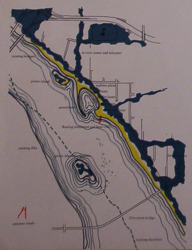
In the story I mention a river concept presented very briefly in a 1959 document called A Plan for Central Tulsa:
A page of that study was devoted to "The Marina," a concept for the river between 11th and 21st Streets. The accompanying illustration showed an artificial lagoon for boats near 15th and Riverside, a floating restaurant and boat club just to the south, a "picnic island" accessible by pedestrian bridge just to the north, and a larger island, accessible only by boat, where the west bank used to be.Yes, used to be. The drawing showed the river almost twice as wide as its existing width at the 21st Street bridge, backed up by a dam at some unspecified location downstream, with the new shoreline just below the west bank levee. The resemblance to last year's "The Channels" plan is uncanny.
I took a photograph of the illustration so you can see for yourself. It's not as sharp as I'd like, but I think you can make it out. Click on the image to see it in its original size.
(Notice that in 1959, the location of the Inner Dispersal Loop, seen along the top of the diagram, has already been determined, although it wouldn't be completed until nearly 25 years later.)
My column this week is also about Tulsa history:
Oklahoma's centennial year ought to be a year when all Oklahomans -- natives and newcomers alike -- encounter our state's history in a way that engages our imaginations. While every year is a good year to study Oklahoma history, this is a year that ought to be hallowed to that purpose, a year for remembering where we came from and how we got to where we are today.
The June unearthing of the buried Belvedere fulfills that purpose quite well. I propose extending that glimpse back 50 years with the Tulsa 1957 project, which I launched here a while back and explain in detail in the column. I also mention a couple of websites which are helping to capture everyday life in Tulsa as it was. (But I neglected to mention Jack Frank's wonderful Tulsa Films series, which uses TV footage and home movies to bring decades past back to life.)
Also this week UTW gives a rave review to the source of the coffee and quesadillas that helped fuel my 6,000-word feature story. Katharine Kelly gives the Coffee House on Cherry Street five stars each for food, atmosphere, and service.
RELATED: A pretty thorough outline history of the Arkansas River in the Tulsa area.
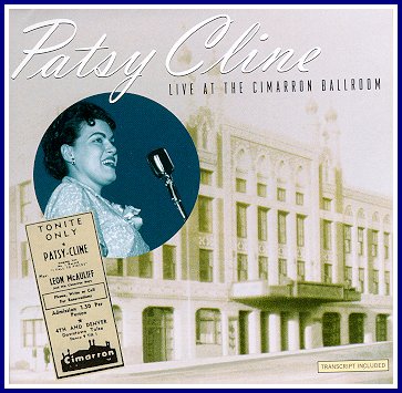
This is not quite 1957, but it is certainly from the same era, and it will give you a sense of the kind of entertainment that was available in downtown Tulsa back in the day.
In June 1961, Patsy Cline was a passenger in a head-on collision and was thrown through the windshield. Just six weeks later, on July 29, still scarred and hobbled by her injuries, she performed her first concert since the wreck.
The venue was the Cimarron Ballroom at 4th and Denver in downtown Tulsa, in what was once the Akdar Shrine Mosque. (It was demolished in the '70s for parking, and the site is now home to the Tulsa Transit station.) This was the home of Leon McAuliffe and his western swing band, the Cimarron Boys. McAuliffe was steel guitar player for Bob Wills and His Texas Playboys during their formative years in Tulsa, but he started his own band in Tulsa after serving in World War II. McAuliffe and his band served as Patsy's band that night.
And that night in July 1961, the sound man decided to roll tape. Thirty-some years later, the reel-to-reel tape resurfaced, and in 1997 it was issued on CD: Patsy Cline: Live at the Cimarron Ballroom.
The Tulsa City-County Library has several copies of the CD circulating. I just checked it out today and listened to it for the first time.
The recording is not an audiophile's dream -- there are a few dropouts, there was feedback on a couple of songs -- but it's still a live performance by one of the most amazing vocalists of the 20th century, backed by a great western swing band. The CD includes the between-songs banter between Patsy and the band and the audience. And we get to hear Patsy Cline without the heavy production of her Nashville sessions. The liner notes include photos of Patsy at the Cimarron, a transcript of the spoken parts of the recording, and, on the back, a facsimile of a poster advertising the event.
For those used to strict segregation between musical genres, the set list will be a surprise. It includes some of her hits ("I Fall to Pieces," "Walking after Midnight," "Poor Man's Roses"), and covers of classic Dixieland ("Bill Bailey"), western swing ("San Antonio Rose"), and Hank Williams ("Lovesick Blues") songs, plus two rock-n-roll tunes: "Stupid Cupid" and "Shake, Rattle, and Roll."
Here are several articles that tell the story of this performance and how it came to be issued on CD, plus a couple of reviews of the CD.
From Guy Cesario's PatsyClineTribute.com
From the Milwaukee Journal-Sentinel
A short review by Robert Christgau
Providence Phoenix review (via Google cache)
This entry isn't specifically about Tulsa in 1957, but this is what many Tulsans would have been watching on KOTV channel 6 on December 31, 1956. It's The Jack Benny Show, a weekly half-hour variety show, sponsored by Lucky Strike cigarettes.
The show features a cameo from strangely cantilevered Jayne Mansfield (sans lobsters), a song and dance number with The Sportsmen and Eddie "Rochester" Anderson, and a talent show segment featuring Mel Blanc as Stanley Gropff, animal impressionist. You'll see commercials for Lucky Strike ("It's TOASTED to Taste Better!") and Tareyton cigarettes, and in case you ignored the commercials, they even worked a pitch for Luckies into the song and dance number.
It's in three segments on the Daily Motion video site:
Part 1 (Jayne Mansfield, Rochester)
Part 2 (Mel Blanc, the "Landrews Sisters")
Part 3 (The "Landrews Sisters", the jujitsu expert)
The second part, with Mel Blanc, is the funniest of the three.
Via Mark Evanier, whose fascinating blog "news from me" is chock full o' vintage TV videos and anecdotes. You'll want to read his entry to learn something interesting about one of the actresses in the Landrews Sisters bit.
Oh, all right, here's another one, from 1960, set at a department store with Jack as the Christmas shopper from Hell, featuring Mel Blanc (as a long-suffering clerk), Frank Nelson (as a supercilious floor walker working his way down the ladder of success), Eddie Anderson, Dennis Day, Richard Deacon, and Don Wilson. Part 1, Part 2, Part 3.
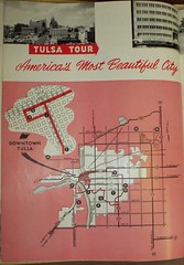
One of the most interesting artifacts I've found from 1957 thus far is a glossy, color, 44-page tourism magazine called Tulsa, I.T. (There's a copy of it in the buried Belvedere.)
I have photocopied all the pages and plan to scan and post a complete black-and-white version sometime soon. While it isn't directly representative of everyday life for Tulsans in 1957 -- which is what I'm aiming for with this "Tulsa 1957" effort -- it does tell you what the folks at the Chamber of Commerce thought was most important for outsiders to know about our fair city.
And these two pages, in particular, tell us what the tourism people at the Chamber thought visitors to Tulsa ought to see, even if they only had a few hours to tour the city. This is the Tulsa Tour.
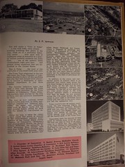
If you'll click on those thumbnails, they'll lead you to Flickr, where you can download the humongoid 4 MB original images or smaller images if you prefer. I photographed those pages with a cheap Kodak digital camera on "best" setting. I did not attempt to press the book flat, out of respect for its fragility, so the images are not like you'd get from a flatbed scanner, but the text is still legible and the detail isn't bad.
Here is the text:
TULSA TOUR
America's Most Beautiful City
By J. P. ArwoodYou will enjoy a "Tour of Tulsa" . . . a city with wide, clean streets . . . towering buildings that gleam in the clear, fresh air of a smokeless industrial center . . . mile upon mile of residential areas as beautiful as a quarter million prideful residents can make them . . . one of the nation's finest vacationlands right next door . . . and general living conditions that are unexcelled in the United States.
This is Tulsa . . . the kind of city you'd plan if you could build your own.
The Tulsa Tour originated in the late '30s when the Tulsa Chamber of Commerce decided to show off this sparkling new city that had merged from obscurity to become a metropolis of international importance in just three decades.
The durable reflective signs that blaze a clear trail through the Tulsa of today were provided by the Tulsa Chamber of Commerce. These attractive markers were erected by the City of Tulsa and are currently maintained by them.
The tour, as now outlined, covers the downtown area with its clean, metropolitan canyons and "diamond sidewalks," the smart new residential areas such as Ranch Acres and the older palatial homes sitting far back from the streets on tree-covered estates.
Along the way, it takes the visitor to such places and points of interest as the ultra-modern national headquarters of the United States Junior Chamber of Commerce; Oklahoma's most photographed church, the Boston Avenue Methodist; the nationally famous Municipal Rose Garden with more than 12,000 plants covering symmetrically designed grounds; Utica Square with its acres of modern suburban shops; Philbrook Art Center where a treasure of paintings and sculpture is displayed in a setting of Italian Renaissance splendor; the International Petroleum Exposition grounds where the world's oilmen gather by the thousands every four years to buy, sell and see the newest tools of their fascinating trade; the Tulsa State Fairgrounds where the nation's largest exhibit barn is to be found; and the University of Tulsa, famous in the sports world for its might in the football bowl games of the '40s, but more famous scholastically for its outstanding curriculum, especially in the field of petroleum engineering.
In addition to the scenic and residential points of interest there is an alternate tour which leads across the 21st street bridge to Quanah Avenue in West Tulsa. To the left will be seen The Texas Company's refinery and tankfarm. To the left as you approach the 11th street bridge is the D-X Sunray refinery where a conducted tour may be made. As you proceed across the 11th street bridge, the first street to your right is Riverside Drive which will lead you to the point where you left the residential tour.
Tulsa county's new $4 million courthouse, the new inspiring YMCA, the fabulous Gilcrease Institute, Mohawk park and zoo, and the American Airlines Overhaul and Supply Depot are places and points of interest well worth seeing, even though they are off the beaten path of the Tulsa Tour.
Depending upon the amount of time spent at various stops along the way, the tour can take an hour or an afternoon or a whole day. But regardless of the time allotted for sightseeing, the best way to view the Oil Capital is to follow the red arrows on the Tulsa Tour markers.
Some notes:
The downtown skyline shot is looking north along Boston with 8th & Boston in the foreground. The tallest buildings in the background are the NBT Building on the left and the Philtower on the right.
Note the city boundaries. Everything fits within a 10 mile by 7 mile box, and most of the space in that box is empty. It's apparent why Utica Square would be considered "suburban" at the time. Note that New Haven Avenue, connecting dots 9 and 10, is within the city limits, even though it's on the fairgrounds (just west of Bell's, the Pavilion, and the Armory).
Note the highway locations in the map. The 51st Street bridge is open, but there's no Skelly Bypass yet. The Skelly Bypass really would bypass everything. US 75 and US 169 are swapped from the present day configuration in how they approach from the north.
Questions for discussion:
- Anyone else remember those signs? They were still in existence in the '70s, but I think they were blue by then. I am almost certain there was one near Holland Hall's old campus at 26th Place and Birmingham.
- What, if anything, strikes you as odd, amusing, or puzzling about this list?
- What were they overly proud of?
- What did they overlook that should have been a point of pride?
- How many art deco buildings do you see in this list?
- How many buildings or places do you see that we would now consider historic or worthy of preservation?
- Anyone want to create a turn-by-turn description of the route shown on the map? Is it still driveable today?
- If you were to create a modern day Tulsa Tour, what landmarks would be on it?
I've had this idea of trying to capture life in Tulsa as it was in a particular year, before freeways, urban renewal, and the flight to the suburbs began to change it. It's hard to believe today, but Tulsa was once one of the twenty most densely populated large cities in the nation. It might help us reimagine what a revived, dense urban core for Tulsa would look like if we could get a vivid picture of what Tulsa's urban core looked like when it was dense and full of life. It seems a fitting project for our state's centennial year.
For this thought experiment, I picked 1957 as the target year. That was the year of the state's semi-centennial. The new County Courthouse had opened and the first massive redevelopment project -- the Civic Center, originally just four blocks between Denver and Frisco, 4th & 6th -- was just beginning to take shape. Early suburban neighborhoods and shopping centers, like my own Mayo Meadow, had been opened. The city's first freeway plan was drawn up -- it still isn't finished, and part of it never will be. A master parks plan called for a massive park along 71st Street from the river stretching through the hills to the east. In June 1957, a Reader's Digest article about Tulsa mentions that Tulsa had taken to calling itself "America's Most Beautiful City." 1957 is recent enough to be in living memory -- childhood for the early Baby Boomers, high school and young adulthood for my parents' generation -- but distant enough to be a very different world.
While I wanted to fix on a particular year for the sake of creating a snapshot in time, reminiscences from earlier and later years, like the memories of the early '60s at Riverview School, will help to make the picture vivid.
I'd like to flesh out this idea with maps -- big maps showing where the city limits were, little maps showing the stores, schools, and churches in a neighborhood -- photographs, news stories, and lots of personal reminiscences. The Sanborn Fire Maps, the city directory, the phone book, and newspaper ads can be used to help refresh and correct those reminiscences.
(It would be a big help if someone had software that could be used to create a base street map of Tulsa and environs in 1957.)
I'm not only interested in the memories of Tulsans, but also those of people who lived in surrounding towns, rural Tulsa County communities (like Alsuma, Lynn Lane, Union, Rentie Grove), and outlying Oklahoma towns like Nowata and Tahlequah who remember trips to the big city as a big deal.
This idea is inspired in part by a cartoon map that appeared in the very first issue of Urban Tulsa. The map showed the adventures of a group of boys, maybe 10-12 years old, who took the bus into downtown Tulsa on a Saturday morning in the early '60s -- they saw a movie, explored the seedier parts of downtown, had a Coke at a soda fountain, browsed through comic books. The map promised "To be continued" but it never was. Those are the sort of memories I'm hoping to capture.
I wasn't around in 1957, and I can't devote a lot of time to this, so I'm looking for help. Anyone interested?