Tulsa 1957: November 2011 Archives
 Tulsa Metropolitan Area Planning Commission (TMAPC) chairman Bill Leighty came across a wonderful documentary short subject about Tulsa. The 15 minute film was part of the Cities in America series, produced by the United States Information Service, the Cold War-era organization that used a variety of media to promote a positive image for America overseas.
The film tells the story of Sam Carson, a long-time Tulsan who had watched the city develop from its early days, his son Henry and daughter-in-law Ellen, and his grandchildren, Tom, Eddie and Janet. I'm curious to look them up in the Polk directory.
The film shows downtown Tulsa in its post-World War II heyday, with scenes on Boston and Boulder Avenues, a brief shot of kids emerging from a Saturday matinee at the Delman Theater. If you look closely and quickly, you'll spot the Beacon Building when it still had a beacon on top, 320 Boston when it was the National Bank of Tulsa. The University of Tulsa dominates one section of the film, and you get brief glimpses of the American Airlines maintenance facility and the lovely Art Deco municipal airport terminal.
At some point, I hope to give this little film the full James Lileks treatment, a lengthy blog post with still shots and details about each. I'm intrigued by one brief scene about 5 minutes in, showing a modern looking Oklahoma Tire & Supply store (you may have known it as OTASCO), with Vandevers in the background. The next scene shows a modern facade on a dress shop called Dorothy's. It ought to be possible to date the film by some of the features. Near the end of the film, it's mentioned that the Arkansas River has not yet been dammed. There are brief shots of a school, a library, and a park.
For now, enjoy, and tell us if you spot anything or anyone you recognize.
MORE: Architect and Tulsa history lover Paul Uttinger has written a scene-by-scene commentary, identifying locations in the film, and he thinks he's pinpointed the date:
1. On the map of Tulsa (time mark 1:05), West Tulsa and Garden City are shown east of the river. East Tulsa is shown north of the CBD. Trovillion is shown to the southeast of the CBD. I've read that Alsuma was re-named Trovillion for a short time. Howard is shown east of downtown Tulsa, about halfway between Trovillion and Dawson. I've never heard of a place called Howard there.
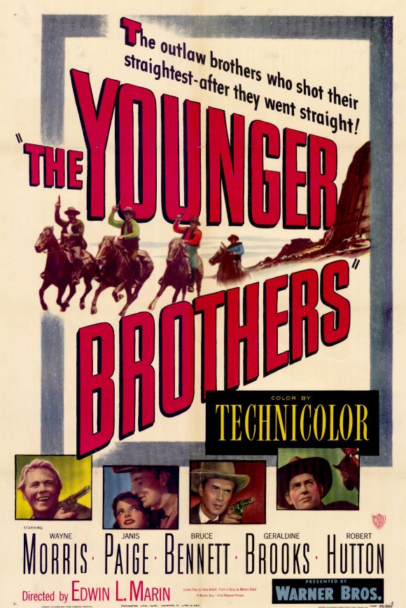
2. (1:44) Outside the Delman Theatre, Sam Carson waits for his grandchildren. He looks at the placard for The Last Round-up, starring Gene Autry. A poster for The Kissing Bandit, starring Frank Sinatra, is displayed in the window behind the placard.
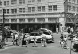
3. (2:05) Sam, Janet, and Eddie walk north toward 3rd Street on Boulder Avenue in front of the World and Tribune building. The bottom of the Skelly Building sign is visible behind them. On the west side of Boulder, we can see the Citizens State Bank ( http://www.tulsalibrary.org/JPG/B1911.jpg ) and the Beacon Building at 4th, part of the Petroleum Building and the Halliburton-Abbott Building (with the Sears store sign) at 5th, the corner of the Medical Arts Building at 6th, and a spire of Holy Family Cathedral at 8th. There's two-way vehicular traffic on Boulder.
4. (2:15) The Carsons walk west on 4th, heading toward Boston Ave. Two-way traffic on 4th.
5. (2:21) The three have turned south on Boston. They're on the sidewalk next to what was originally known as the Cosden Building, which is now the old portion of the Mid-Contintent Tower.
6. (2:34) They're still walking south on the east side of Boston, but suddenly they are north of 4th Street again!
7. (2:44) Eddie and Janet wave to a policeman from the northeast corner of 4th & Boston. The policeman appears to be standing next to the Pioneer Building, but I don't see the Bell System "Public Telephones" sign that was displayed on that corner ( http://www.tulsalibrary.org/JPG/B9978.jpg ).
8. (2:55) The Carsons look at an oil boom display in aPhiltowerPhilcade window. (CORRECTION from Paul Uttinger: "They are south of 5th, so it's not the Philtower, as I said in a previous email. It's probably the Philcade, around 511 S. Boston. The construction sign for the First National Building is across the street in the same scene, so that definitely dates the film prior to July 1950, when the tower was slated to open for business.")
9. (4:49) Looking south on Boston from the Katy tracks. The First National Bank Building appears to be under construction, with a crane leaning out over Boston near 5th Street.
10. (4:53) Looking northwest at 4th & Main (Arby's is there now).
11. (4:55) Northeast corner of 4th & Main (Ken Brune's Reunion Center Bldg now).12. (4:58) 5th & Boston, looking east. We can see the corner of the Philcade Building and the sign for the D-X service station at 502 S. Cincinnati ( http://www.tulsalibrary.org/JPG/D4283.jpg ).
13. (5:16) A brief moment of racial integration. West side of Main, 300 block, looking north. The pedestrians are on the sidewalk next to the Froug Department Store and Kinney Shoes (World Publishing's big and brutal facade is there now). The bottom of the Holly Store sign is in the background at the beginning of the scene. There's a warped reflection of the Globe Clothiers sign, which projected from their store building at 217 S. Main. There's a reflected "NS," which could be part of the signage at Stein's, which was on the southeast corner of 2nd & Main. The 3-story building which stood on the northeast corner of 3rd & Main is reflected in the shop fronts, too.
14. (5:24) Looking northwest near 6th & Boston. The Vandever building spans over the alley between Main and Boston, and an old Vandever's sign is still faintly visible from 6th Street today. The view of the sign we see in the short film has been blocked by the Enterprise Building since around 1954. In the film, Burt's Malt-A Plenty Ice Cream store is on the corner where the Enterprise Bldg is now, just north across 6th St from the Oklahoma Tire Supply building.
15. (5:27) Another moment of racial integration on a public sidewalk? Dorothy's was a clothing store for women, but in those days, men went there for a particular pre-Christmas event:Recently, men have been returning to "occupy" that location once again.
16. (5:31) Back to the World and Tribune building on Boulder, between 3rd and 4th.
17. (5:34) Renberg's and Clarke's on the east side of Main, 300 block. I noticed that Renberg's changed their logo in the 1948 Polk directory to the lowercase type face we see in the short film and on the facade of the building today. The last time I peeked inside a few years ago, Renberg's former ground level sales floor had been converted to a parking garage.
18. (5:40) Looking south at the Boston Avenue Methodist Church tower from 12th Street. The Fred Jones Ford dealership is on the southeast corner ( http://www.tulsalibrary.org/JPG/D4611.jpg ). Wat Henry Pontiac is on the southwest corner ( http://www.tulsalibrary.org/JPG/C1589.jpg ).
19. (7:08) The exterior of the "Carson" residence at 1735 S. Detroit Ave. In the 1946, 1950, and 1955 Polk directories, James Forster is listed at that address.
20. (7:14) Part of the house at 1725 S. Detroit is visible as Tom Carson leaves home to catch a bus to TU.
21. (7:19) Tom hails the "N. Denver" bus at 18th & Detroit. The bungalow at 302 E. 18th is visible in the background. The bus is heading west on 18th (7:29). (CORRECTED bus direction from "S. Denver")
22. (12:37) Looks similar to a few of the tanks near 21st & 33rd W Aveune ( http://tinyurl.com/TulsaTanks ).
23. (13:53) A partial view of the old Art Deco style Municipal Airport building.
24. (14:21) Looking southwest at 6th & Main.
25. (14:29) Old Public Library building at 3rd & Cheyenne. A bit of the the Mid-Co Bldg is visible in the background.
26. (14:37) 12th between Columbia Place and Delaware Avenue, looking northwest ( http://tinyurl.com/WilsonMS ).
27. (15:04) Henry Carson smoking somewhere northeast of the CBD. The final skyline view might have been shot from the top of the hill near North Elgin and Independence, judging from the perspective.
My best guess is that most or all of the local filming was done during the warmer months of 1949, based on the clothing worn by pedestrians and TU students, the lush foliage, the release date for The Kissing Bandit, and in-progress construction photos of the First National Bank and Trust building in the Beryl Ford Collection.
UPDATE: Paul sends along another confirmation of the 1949 date:
Another movie poster displayed at the Delman. I think it's for The Younger Brothers, which was released on May 3, 1949, according to Internet Movie Database. I can't see much of the Delman's poster, but the Technicolor film starred Bruce Bennett, Geraldine Brooks, and Robert Hutton, which all seems to jibe with what I can make out when Grandpa Carson and the kids leave the theatre.
A peek through the movie ads in the newspaper microfiche for May '49 might nail it down.
He also sends a link to a sharper version of the Tulsa film found on YouTube:
YouTube user Ella73TV2 has posted hundreds of public-domain historical documentaries of this sort.