Tulsa 1957: Restaurant map
As I mentioned in my initial Tulsa 1957 post, I wanted to be able to create maps showing where things were back then. I finally figured out a relatively easy way to do it, using Google Earth, and I found a number of online tools to minimize the amount of development work I would need to do.
My first exercise was to create a KML file showing all of the more than 400 restaurants listed in the classified section of the 1957 Polk Directory of Tulsa. The usual GIGO warning applies. If the Polk Directory was wrong, the file will be wrong.
I would like to add, but have not yet added, non-duplicate entries from the Southwestern Bell Yellow Pages. I'm limited there because a quarter of a page from the "Cafes" section of the 1957 phone book was torn out.
Google Earth makes it possible to include all sorts of information in a map -- with enough time and energy, you could include images of newspaper and phone book ads and building photos.
To build the file I used Excel to enter name and address, then used an online tool called BatchGeocode to convert each address to a latitude and longitude and to create a KML file, which Google Earth can read. I had to do a bit of tweaking to get the icons I wanted, and the Geocoder had trouble with some addresses that no longer exist (e.g., the 100 block of South Main, the 500 block of East Brady and East Cameron). (I pre-modified Sapulpa Rd and Sand Springs Rd addresses to the modern day names of Southwest Blvd and Charles Page Blvd.) For some reason, Pennington's Drive-In wound up in the south Atlantic Ocean, but I fixed it.
Google Maps can load and display small KML files, but not a KML file with 400 entries. So you'll need to have Google Earth installed on your PC to get the full effect. In Google Earth, you'll be able to hover over an icon to see the name, and click on it to see the address. Here again is the link to the KML file of Tulsa's restaurants in 1957 which you can download and use in Google Earth.
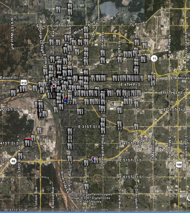
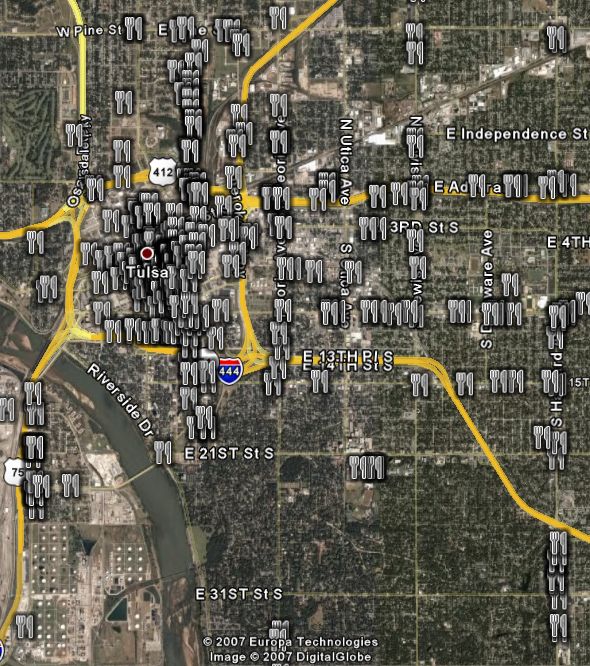
For those without, and until I can figure a dynamic way to display the map online, I've provided some screenshots from Google Earth below the fold. One is zoomed out to show the location of all restaurants in the city, the other is zoomed in to provide more detail between Pine and 36th, Union and Harvard.
A cool idea for future implementation: Google Earth is able to display a fourth-dimension -- time. If you could compile the restaurant listings for each year, you'd be able to move the time slider back and forth and watch as one restaurant replaces another, and as restaurants move out toward the suburbs. What an amazing way that would be to visualize the development and undevelopment of the city over time.
Speaking of undevelopment, notice some of the clusters of restaurants. There are eateries on nearly every block downtown, and there's a linear cluster extending north of the expressway -- that's Greenwood -- the Black Wall Street of America. There's a cluster along Quanah / Southwest Blvd in west Tulsa (another urban renewal removal). Sheridan Road was the key commercial link between the airport and the rest of the city.
I hope to post more KML files in the future, covering places like drug stores, groceries, churches, beer joints, bowling alleys, and movie theaters. It would speed up the process if some of my readers were willing to help transcribe phone book entries. I'm not quite set up to accept help, but in the not too distant future, I will be able to send you an image of a page from the Polk Directory and a template Excel spreadsheet for you to fill in. Let me know if you'd be willing to help in that way by e-mailing me at blog at batesline dot com.
And as always, if seeing the name of an obscure restaurant stirs some memories, drop me a line and tell me about it.
Pictures after the jump:
UPDATE: Here's a link to Google Maps with the KML file loaded.
UPDATE 2023/09/05: That Google Maps doesn't work any more, but I have uploaded the 1957 Tulsa Restaurants KML file to an online viewer, KMZView, that will allow you to click on a restaurant in the list and navigate to that point.
0 TrackBacks
Listed below are links to blogs that reference this entry: Tulsa 1957: Restaurant map.
TrackBack URL for this entry: https://www.batesline.com/cgi-bin/mt/mt-tb.cgi/2907