Tulsa streetcar and interurban lines in Google Maps
In response to a thread at TulsaNow's public forum, here is a map showing the routes of Tulsa's three streetcar/interurban lines: Red is the Tulsa Street Railway, blue is Oklahoma Union Traction, and green is the Sand Springs Railway. The latter two lines had interurban routes to Sapulpa and Kiefer and to Sand Springs respectively, and the interurban tracks continue to provide diesel freight service. OUT is now known as the Tulsa-Sapulpa Union Railroad. Click the picture to see a much bigger version.
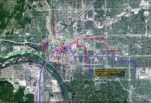
To make it easier to explore the routes, here is a Tulsa streetcars and interurbans KMZ file, for use with Google Maps and Google Earth.
The routes are largely based on maps and text in the book When Oklahoma Took the Trolley, as well as some documents from City of Tulsa archives. If you have any corrections or questions, please leave a comment below or drop a line to me at blog at batesline dot com.
UPDATE 2019/10/10: Google changed the way it does embedded maps and KML overlays, so I need to change the display approach. Here are some notes for a future revision of the map, based on subdivision plats that show the tracks:
Owen Place subdivision (1910): A turnaround for the Tulsa Street Railway. The single track comes north along Nogales Ave to the junction with Easton St., just south of Owen Park, then loops to the west before rejoining the track.
Hollywood subdivision (1923): Street railway (the Oklahoma Union Traction) coming north on Quanah, through a "subway" under the MK&T tracks, then turning west on Brady Street.
Park Hill subdivision (1910): Union Traction Co. tracks traveling west along Archer, then north on Ralston (now Rosedale Ave), then branching east and west at Easton. The east branch crosses Quanah and had a turnaround in the west entrance to Owen Park. The west branch continues to the edge of the subdivision at County Road (now Union Ave).
Irving Place subdivision (1910): Street railway tracks on Easton Street for the full width of the subdivision, from Union to west of Xenophon, with a diversion for the Washington Irving monument at the intersection of Easton and Vancouver. Plats for the subdivision to the west (New Irving Place, and New Irving Place 2nd Addition) don't show any streetcar lines, but the Easton Street is on the subdivision boundary.
The Tulsa City-County Library digital collections has a map showing Tulsa enumeration districts for the 1920 census. The base map is titled "Street Map of Tulsa, Okla., E. W. Swart, Phone 1511, 207-A S. Main," and a Bureau of Census date stamp says May 5, 1919. This map predates street name reform, so there are all sorts of interesting name variations, some of which have hand-written corrections. A 40-acre Catholic cemetery is shown on the SE 1/4 NW 1/4, S18 T19N R13E; today that's the southern half of the Terwilliger Heights subdivision. It also shows street car and interurban lines:
University of Tulsa, McFarlin Library, Special Collections has a 1921 City of Tulsa map showing streetcar and interurban lines:
- The TSR Main Street/Cheyenne Ave line ends at Marshall Street on the north and 18th Street on the south, although the poor scan makes it hard to tell. From Marshall Street, south on Cheyenne, east on Cameron, south on Main to 18th (Boulder Park).
- The TSR Bellview-Owen Park line begins at a point where Nogales would intersect with Easton, if those streets were extended from the south and west. (Owen Park's southern boundary is shown as lining up with Easton Street to the west.) South on Nogales, east on 3rd Street, south on Madison, east on 5th Place, south on Quincy, stopping at 15th Street.
- The TSR North Peoria-South Frisco line begins at Peoria and King (possibly Latimer, but the scan is poor quality), south on Peoria to 1st, where it joins the Kendall line, west to Madison, south to 3rd, west to Main, south to 5th, west to Frisco, south to 12th (Riverview School).
- The TSR Kendall-West 5th line begins at College and 7th, west to Atlanta Ave, north to 5th St, west to Lewis, north to 1st St, west to Madison, south to 3rd, west to Main, south to 5th, west on 5th to where 5th runs into 7th, near Jackson Ave.
- The OUT Interurban from Sapulpa is shown coming up along what would be Santa Fe Ave on the west side of Howard Park and the east side of Mid Continent Park, then bending east at 23rd Street to run parallel east of the Frisco tracks, diverting to run across the original 11th Street bridge. On the east side of the bridge, the tracks ran north on Maybelle to 7th, then diagonally NE to 1st and Guthrie to join with the streetcar line.
- The OUT streetcar line is shown as starting at Easton and Rosedale (no branches east or west along Easton), south to Archer, east to Lawton, south to 1st, then east to Elwood, south to 4th, east to Elgin, south to 11th, east to St. Louis, south to 19th St. at the southwest corner of Swan Park. (The St. Louis stretch was removed in late 1921, and the OUT built further along 11th to Delaware, 13th, Louisville, to the Fairgrounds.)
- The Sand Springs Interurban is shown passing along the southside of Crosbie Heights, under the hill, then parallel on the northwest side of the Frisco tracks, then past 1st street turning north a half-block east of Lawton, then east on Archer at Guthrie, along Archer to east of Elgin, then curving to Brady and Greenwood, then north on Greenwood to Haskell, then northeast to link to the Santa Fe tracks near King Place.
Some USGS quadrangles show streetcar lines:
USGS Kiefer Quadrangle, 1916: Shows the Oklahoma Union Traction electric railway line from Hickory and Hastain in Sapulpa to Indiana (151st St S) and Stark in Kiefer, as well as the branch extending west from Lee and Hickory in Sapulpa along the south side of Dewey to Rock Creek. Also shows Midland Valley branch to Glenpool.
Newspaper stories report the extension and contraction of the streetcar systems:
Tulsa World, June 20, 1914, p. 3: Tulsa City Commission granted permission for the extension of Tulsa Street Railway in the Central Park area will start at 3rd and Madison, run south to Fostoria (5th Place), east to Quincy, then south to 11th, where it would end for the time being.
Tulsa Democrat, July 2, 1914, p. 8: Tulsa Street Railway to remove annoying 2nd Street loop.
Tulsa World, May 11, 1919, p. 18: Half-page ad for Hunter Addition (on North Peoria, just past the Santa Fe tracks) boasts that the car line is under construction and the road is under contract for paving Peoria to Turley.
Tulsa World, February 5, 1920, p. 38: Quarter-page TSR listing system improvements over the preceding year and a half: Double-tracking of several sections, completion of North Peoria Line (after city injunction lifted), extending Main Street line on Cheyenne as far as Marshall, with plans to go to Orlando, plans to extend Frisco line from 12th to 15th.
Tulsa World, October 23, 1920, p. 23: Hunter Addition ad, Peoria and Washington (now Pine). "Street car within five blocks now."
Tulsa World, October 26, 1920, p. 17: 521 N. Peoria is on car line.
Tulsa World, December 26, 1920, p. 11: TSR advertisement listing streetcars delayed five minutes or more at railroad crossings. (Agitating for subways?) Locations are Main at Frisco, Kendall at Midland Valley (at 3rd?), North Peoria at Midland Valley (at 3rd?).
Tulsa World, January 9, 1921, p. 21: A room to let at 1324 E. Hodge can be reached by taking the North Peoria, Kendall, or 2400 E. First Street car to Peoria, then walking one-half block east.
Tulsa World, January 22, 1921, p. 13: A TSR motorman is held up by the lone passenger for $14 in fares and $5.50 in tickets on the North Peoria line under the viaduct.
Tulsa World, March 22, 1921, p. 1: Four inches of rain cause flooding under both Denver Ave viaducts and the Peoria Ave viaduct. Motorman switched off the motor to try to coast through the water, but passengers had to put their feet on the seats to keep from getting wet. After getting to the other side, he switched the power back on and shorted out the motor.
May 26, 1921, p. 15: Ad for kitchenette to let advises to catch the North Peoria line at 3rd and Main, get off at Peoria, then walk two blocks south to 3rd and Peoria.
Tulsa World, September 11, 1921, p. 15: Three unfurnished rooms as 1234 E. Haskell are on the North Peoria car line.
Tulsa World, January 16, 1922, p. 1: Court to decide if Tulsa Street Railway can run a feeder bus line from its terminus at 15th and Quincy, east along 15th, south on Rockford, east on 17th to Utica, with operations to shift from Rockford to St. Louis once construction was complete (the OUT line to Orcutt Lake Park was removed). A seven-passenger car would serve the feeder line until a new bus is delivered.
Tulsa World, May 26, 1922, p. 4: Letter-writer refers to dire state of main roads leading to Tulsa, with particular venom for the Tulsa Street Railway, "antediluvian relic," "old eyesore," "rails protruding 4 to 12 inches above the other part of the street."
Tulsa World, July 8, 1922, p. 6: Tulsa City Commission voted to allow Oklahoma Union railway to extend its 11th St. line east to Kendall, a first step toward a planned interurban line to Claremore. Kendallites would pay a 5 cent fare. The OUR last year demolished its tracks on St. Louis Ave. south of 11th Street, after the Oklahoma Corporation Commission gave permission.
Tulsa World, October 23, 1922, p. 10: An ad for TSR reminds that transfers are good for only 15 minutes, and only when traveling in the same general direction as the car from which the transfer was issued.
0 TrackBacks
Listed below are links to blogs that reference this entry: Tulsa streetcar and interurban lines in Google Maps.
TrackBack URL for this entry: https://www.batesline.com/cgi-bin/mt/mt-tb.cgi/5415
Thanks for color-coding the routes!
I sent you an email with additional information.
Wow, I had no idea a streetcar line ran a half block from my house. It explains the wider residential street. I wonder how a streetcar line would be received in the neighborhood today.