Travel: July 2007 Archives
This may look like a souvenir from my recent trip to Britain with my 10-year-old for the Tulsa Boy Singers choir tour, but it's not, although the trip reawakened an interest in it.
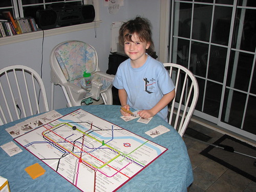
This is The London Game, a strategy game based on a map of the London Underground. The object is to be the first to travel to six tourist destinations and return to your starting point at one of London's main railway stations. There are "hazard" cards that either delay you or allow you to delay another player. Each "souvenir" card has a drawing and a description of the point of interest and the name of the nearest Tube station.
I remember playing this game with a friend of mine when we were probably 10 or 11. His family subsequently put it in a garage sale or otherwise disposed of it. I had always thought it would be a fun board game to have.
Three times in the past I've been to the London Transport Museum gift shop in Covent Garden, and three times I've balked at paying the asking price, not to mention wondering if I had room and sufficient spare weight in my luggage for the box. Last month, the museum shop had a special edition in a metal box for the low, low price of 25 pounds sterling -- about $50, and too dear for me. Once back home, I checked eBay and found a copy of the 1972 edition. I was the only bidder and price and shipping combined came to $15.
While my wife and our 10-year-old went to hear Weird Al Yankovic in concert last Friday, and after I put the 18-month-old to bed, the six-year-old and I played the game a couple of times. We opted not to use the station blocking rule and instead concentrated on getting familiar with where everything is on the board and how the basic rules work.
We added a rule that you have to say the name of each station as you pass through it. I figure it'll help the kids learn to pronounce Gloucester, Leicester, and Tottenham correctly and how to interpret a map and plan a route, and we'll all build a mental map of London which will come in handy when we go back as a family someday. There have been a few changes to the Tube map since 1972, but not many to the central London section that makes up the game board.
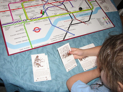
We had fun playing it, and we each won a round. I'll have to try the more cut-throat version, where you can block stations to delay your opponents, with the 10-year-old.
One of my earliest blog entries was about a brief visit four years ago to Riverside Park in Independence, Kansas, on the way home from seeing my cousin graduate from Lawrence High School.
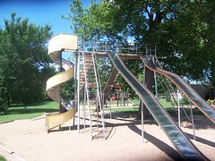
Last Saturday, my uncle was celebrating his 50th birthday, so I drove myself and the toddler north, stopping in Riverside Park for a couple of hours on the way up. (There were also the requisite Sonic stops -- three in all.) We spent some time looking at the animals in the Ralph Mitchell Zoo (did you know porcupines could climb?), letting the toddler explore Kiddy Land, a nursery-rhyme themed playground created by the local Lions Club, walking through the big kids' playground, admiring the statue of a corythosaurus (a bit of Forgotten New York from the 1964 World's Fair), riding the carousel (still just a nickel) and the train (only a quarter), and envying the crowds cooling off at the city's water park.
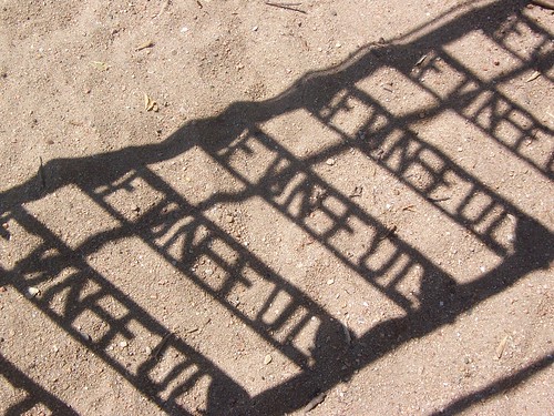
In that earlier entry, I described in detail the wonderful old-fashioned playground equipment, much of it bearing the FUN-FUL brand. These are playground pieces you don't see in parks anymore for fear of litigation. This time I took photos and posted them on Flickr.
I should note that it was a pleasant surprise that we were able to ride the train and carousel. That was the last Saturday afternoon for the carousel and train to be running; the weather is getting too hot. I believe they still will run on Sunday afternoons, but the rest of the week only from 6:30 to 9:30.
Our route took us through the area along the Oklahoma-Kansas border that was so badly flooded only a week ago. Johnstone Park in Bartlesville was closed, but people were at work in the Bartlesville Playground (the Kiddie Park) getting it cleaned up. (The park was not yet open for business.) Highway 123 between Bartlesville and Dewey is flood-prone; the old KWON studios were built on stilts. A big tent, the kind used for outdoor sales or wedding receptions, was set up in front of the old radio station, and the stain from the flood reached at least two feet higher than where the roof met the sides -- probably 10 feet above the ground. Mud stains on the trees lining the highway told the same story.
Further north in Kansas, we could see where flood waters had matted down corn fields. The east side of Coffeyville, which we passed through on the way home, nearest the Verdigris River, was like a ghost town. Only the lights along the main road were lit; all other buildings were dark, and the flood stain reached five or six feet up the sides of the buildings.
We also took a detour into Chanute on the way home, in search of a place to buy gas and rest for a minute or two. I was surprised to see how lively the downtown was at about 11:00 p.m. The center of activity seemed to be Fire Escape, a spacious and inviting Christian coffee house on Main Street. (Had I not had a sleepy toddler, I'd have dropped in.)
Some years ago, the Kansas highway department rerouted US 169 to bypass most towns between Coffeyville and Kansas City. They did such a good job, it's often hard to know when you're passing a town. Chanute signed its own business route to help travelers find their way off the main road, through town, and back to the highway.
The toddler slept for the first half of the trip home, but he stayed awake after we stopped. We listened to Bob Wills, and I passed him back his water cup, Pringles, and rolls that my uncle sent home with us.
I'm going to repeat a question I asked after our drive through Kansas four years ago:
I am a proud Oklahoman, and yet I can't help but notice a quality and pride in these Kansas towns that I don't see in towns of similar size in Oklahoma. These Kansas towns seem to be surviving and thriving, while many similar towns in Oklahoma are on the wane, with Main Streets falling into disrepair, storefronts vacant or filled with sub-optimal uses and public spaces showing signs of neglect. The pride I've observed in Kansas I've also seen in many parts of Texas, Missouri, Iowa, Minnesota, Arkansas, and Illinois. What accounts for the difference?
What do you think?
MORE: FUN-FUL playground equipment was made by General Playground Equipment, Inc. of Kokomo, Indiana, a successor to the Hill-Standard Company of 116 Fun-Ful Avenue, Anderson, Indiana. Here's the story of one man's effort to save a spiral slide in Burlington, Iowa, that was made by the company and which had been installed in the 1920s.
Ron of Route 66 News evaluates one of Lady Bird Johnson's legacies:
But the Highway Beautification Act of 1965, which restricted billboards along our nation’s highways, proved to be damaging to Route 66 businesses when they were struggling to survive amid the continuing rise of the interstates.These Mother Road businesses were struggling enough against the chains. Restricting the use of billboards — a crucial advertising tool — made it harder....
[R]ich and powerful companies managed to skirt the law, while many mom-and-pop businesses didn’t have the influence to so.
From family trips back in the early '70s, I remember the stark difference between driving the Turner and Will Rogers Turnpikes and the Indian Nations Turnpike. The Turner and Will Rogers were built in the '50s and had many signs (evidently grandfathered) pointing to nearby Route 66 businesses like the Thurman Motel, Buffalo Ranch, and the Lincoln Motel, along with the requisite notice to save your appetite for a free 72 oz. steak dinner in Amarillo.
The Indian Nations Turnpike, built after Ladybird's Law, had no signs. This meant there was nothing to entice a passing traveler to venture off the highway, no indication that, for example, the McAlester exit could lead him to a land of hearty Okie-style Italian food. A traveler wouldn't know anything about available service stations or accommodations that might be just a few hundred yards away from the turnpike.
For kids, the Highway Beautification Act meant no practical way to play the Alphabet Game.
At some point, states began posting official exit services signs, with little logos to notify the traveler of available restaurants, gas stations, and motels. Of course, this favored the chains as well: An out-of-state motorist would know exactly what to expect from seeing a McDonald's or Cracker Barrel logo, but a logo isn't enough for a local cafe to tell you about its chicken fried steaks and pies.
(Then there was the case of the Okie Gal Restaurant in California, which wasn't even allowed space on the exit services sign because the highway department deemed "Okie" a derogatory term.)
Ron praises Lady Bird's work on behalf of wildflowers, as does Joshua Trevino, writing at National Review Online. You could see the wildflower and anti-sign initiatives as consistent, both favoring the natural over the man-made, but there is also something contradictory about them: Wildflowers are a kind of rebellion of local color against the monotony and standardization of a perfectly green, perfectly manicured right-of-way. But ads along the highway are also a splash of local color, a hint about the distinctive qualities of the next town and the people who live there.
Marvin Olasky mentions in passing another example of the damage caused by "beautifiers":
Coney Island, part of New York City, is famous in American literature and film. In "The Great Gatsby," Gatsby invites Nick to go to Coney Island, and in Clara Bow's 1927 silent film "It," the neighborhood's amusement park is practically a co-star. After 1950, though, waves of officials such as New York City Parks Commissioner Robert Moses looked down on the "tawdry" amusements that characterized the boardwalk area. They pulled strings to substitute tawdry housing projects that became gang havens.Coney Island went through bad decades, but even bureaucrats can't take away the ocean, and the beachfront location has inspired some entrepreneurs to ignore planners' sandcastles and attempt to develop new small businesses and privately owned housing.
Tulsa has had its share of destructive "beautifiers": The barrenness of the Civic Center, the Williams Center, and the OSU-Tulsa campus parking lots are their legacies.
We're hearing reports of moderate to severe flooding north and east of Tulsa. If you're wondering whether you'll need an ark to complete your Fourth of July travel plans, you can ask NOAA.
The website for the Advanced Hydrological Prediction Service has a national map showing all active flood gauges and their current state. Purple means major flooding, red is moderate. Click on the national map and you'll see an area map, and you can then click on an individual gauge to see the flood level in recent days and the predicted level over the next few days. Here's the map for the Tulsa area.
The gauge for the Caney River at Bartlesville shows that the river has crested at 21.45 feet, more than 8 feet above flood stage, but is still about 6 feet shy of the record October 1986 flood. If you'd planned to visit the Kiddie Park, you might want to phone ahead.
Here's a map for NOAA's Arkansas-Red Basin River Forecast Center, which will give you a sense of the extent of flooding around Oklahoma and neighboring states. Not only is there some major flooding in southeastern Kansas and northeastern Oklahoma, but also in southwestern Oklahoma and Wichita Falls, just across the Red River in Texas.
The Oklahoma Highway Patrol posts road closings due to weather, or you can phone (405) 425-2385 or (888) 425-2385. There are a number of warnings and closings in Nowata, Craig, and Ottawa counties.