Tulsa History: September 2011 Archives
This is encouraging news: In a few weeks, as soon as PSO puts the necessary electrical hookups in place, the Bell family of Bell's Amusement Park will be operating a few of their kiddie rides at the Saturday Flea Market in west Tulsa. The rides will be open on Saturdays during the flea market's weekly session.
Saturday Flea Market is at 5802 W. 51st Street S., just about a mile west of the southwest junction of I-44 and I-244. They boast 100 vendors in two climate-controlled buildings and outdoors. It's just east of JRP Speedway.
It's a humble re-beginning, but it echoes the way Bell's Amusement Park began in 1951 with a half-dozen small rides at the County Fairgrounds. It wasn't until 1969 that Zingo, the wooden roller coaster, began operation, and many of the park's other major attractions -- the Phantasmagoria dark ride, Himalaya, White Lightning log flume -- came into being over the course of the 1970s.
It also reminds me of the way the Snyder family brought back the Mayo Hotel: First converting the basement into paid parking, then converting the lobby and mezzanine as an event space, then leasing the storefronts, with each stage providing revenue for the next stage of renovation.
The location is just a couple of miles from the site of the long-vanished Crystal City Amusement Park, on Southwest Blvd between 41st Street and 33rd West Avenue. The site is now occupied by the Crystal City Shopping Center (whose name was the nemesis of radio announcers). Crystal City was home to a roller coaster named Zingo, which became the namesake for the wooden coaster at Bell's decades later. The 1939 Sanborn map shows Zingo ("scenic railway") hugging the highway, a stream flowing through the property (with a monkey island in the middle of it), a massive dance hall, a giant pool with a large bath house, "amusement houses", Dodgem (bumper cars), a ride called "Bug," a few smaller rides, an octagonal refreshment building, ticket offices, and something called Hiram's Barn. TulsaGal has photos of Crystal City Amusement Park from the late 1920s that show many of these features.
(Click the picture to open a very large version of the map in a popup window.)
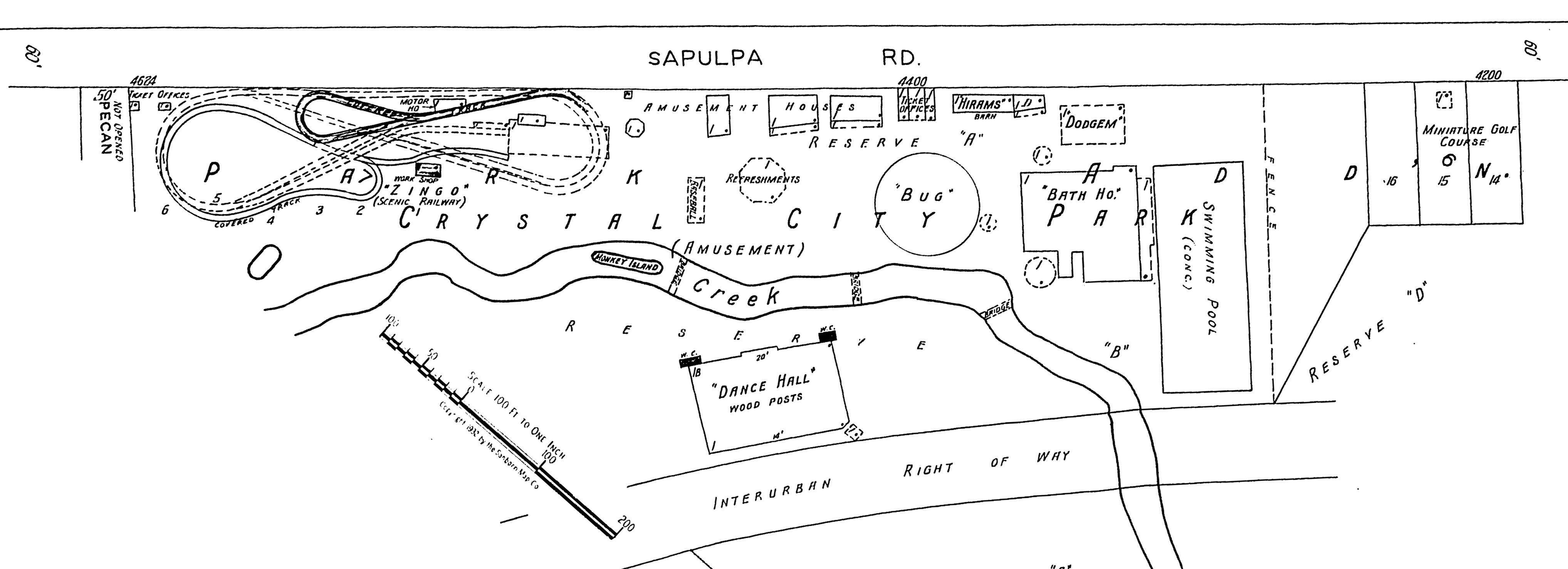
This north-up map provides some context, showing the park in relation to 33rd West Ave., 41st Street, Sapulpa Road (now Southwest Blvd), and the Frisco (now BNSF) tracks.
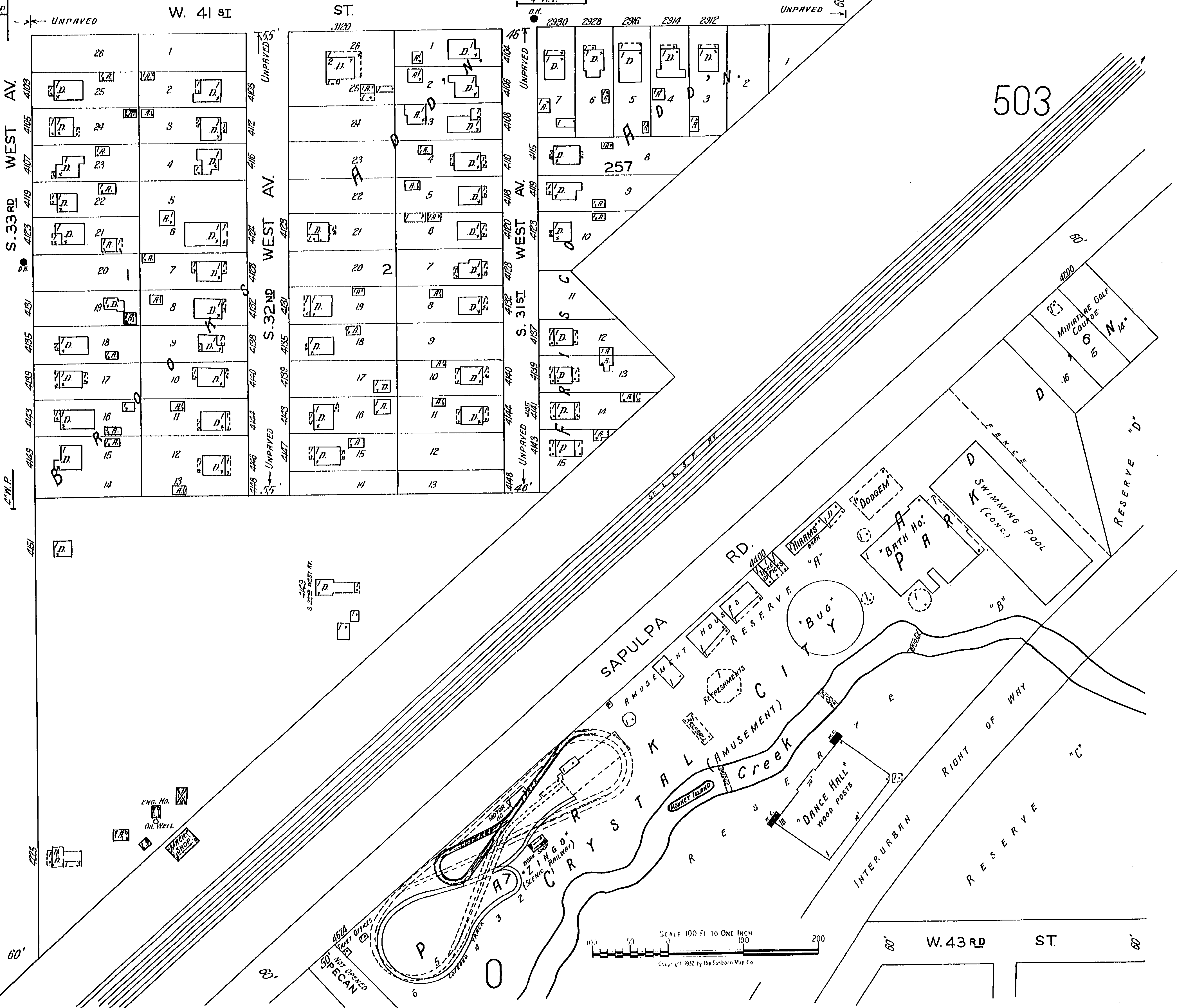
According to the County Assessor's records (parcel 31125-92-27-17380), the Crystal City Shopping Center was built in 1954 and sits on 442,060 sq. ft. of land, a bit more than 10 acres, about the same size as Bell's footprint at the Tulsa County Fairgrounds. Comparing the Sanborn map (Volume 3, Map 501) to the assessor's map, it appears that the highway department routed I-244 around the shopping center, taking homes to the east and moving the Tulsa-Sapulpa Union tracks further east as well. The site of the old amusement park is fully intact.
If I may dream a bit: Wouldn't it be cool to restore Crystal City on Historic Route 66 as an amusement park, right next to a restored Red Fork Main Street? Wouldn't it be cool to run an electric streetcar between Crystal City and the new Route 66 Village? The shopping center has seen better days, there are a whole bunch of rides that need a new home, the site has good visibility from the freeway, and it would give Route 66 travelers even more reason to follow the old alignment through Tulsa.
I came across some research, based on the 2000 U. S. Census, calculating various indicators of racial integration in the nation's 100 most populous metropolitan areas. It points to an impressive degree of progress over the last half century in Tulsa.
According to that paper, 16.3% of the City of Tulsa's population and 9.4% of the Tulsa Metropolitan Statistical Area (MSA) was African-American in 2000.
The researchers analyzed the racial composition of each census block, sorting them into four categories:
- >= 20% Black and >= 20% White (the authors of the study term these "black-white integrated blocks")
- < 20% Black and > 50% White
- > 80% Black
- Other Mixture
A census block is the smallest unit of census statistics. Streets, creeks, railroads, section lines, city limits all serve as census block boundaries. For example, a city block split in two by a railroad track would result in two census blocks.
In the Tulsa MSA, there were 75,471 African-Americans in the 2000 Census. 28.0% lived on blocks where the population was at least 20% black and at least 20% white. 28.7% lived on blocks where the population was less than 20% black and at least 50% white, 36.0% lived on blocks where the population was at least 80% black, and 7.4% on blocks with some other racial mixture.
Put another way, in 2000 64% of African-Americans in the Tulsa metro area lived on racially diverse blocks. In 1960 that number was below 10%. While there is a concentrated area of black population in north Tulsa, two-thirds of Tulsa's black population is scattered across the map.
I don't have census block data on population by race in 1960, but I do have that data by census tract -- areas of a few dozen blocks, often about a 1/2 square mile in area. In 1960, blacks were 8.7% of the City of Tulsa's population. In 1960, 91.6% of Tulsa's blacks lived in six census tracts -- 2, 5, 6, 7, 10, and 11 -- about 4 sq. mi. area bounded roughly by Cincinnati Ave on the west, Mohawk Blvd on the north, the Santa Fe tracks on the east. Outside of the City of Tulsa, the only significant clusters of blacks in Tulsa County in descending order, were the rural part of tract 2 (bounded by Mohawk Blvd, Yale, Peoria, Apache and 36th St. N), the city of Sand Springs, tract 67 (likely that most were in the South Haven subdivision near 51st St and 33rd West Ave), tract 76 (likely around Rentie's Grove), and tract 90 (likely in and around Alsuma)
So we've gone from over 90% of blacks living in a small part of the city in 1960 to living all over the metro area -- 64% outside of predominantly black areas -- in 2000. That seems like progress to me, but the authors of the research don't rank Tulsa as significantly integrated (see their maps of Tulsa) because there are so few blocks on which the population is at least 20% black and at least 20% white. In a city where the overall black population is less than 20%, that doesn't seem like a good measurement of integration.
Of course, geographical integration isn't necessarily a good measure of social integration either, as we tend to connect with people we know from church, school, and work and may not spend much time with our own neighbors.
Here are a couple of maps from the 1960 census reports, showing tracts in and round the City of Tulsa and for the rest of Tulsa County. I've superimposed pairs of numbers on some of the tracts. The first number is the number of blacks, the second is the total population of the tract. Red numbers are inside the city limits; blue numbers are outside. Click the pictures to view full size:
I'm working on analyzing the C-1 forms submitted by candidates for Tulsa City Council. In the process of locating real residential addresses for donors who insist on listing their business addresses, I needed to look at Osage County land records, and while I was there, on a whim I searched for "WILLS JAMES" as in James Robert aka Jim Rob aka Bob Wills. Wills owned a ranch described as "north of Tulsa" where he and his extended family lived. I'd always wondered exactly where it was.
His dream was to retire there with his whole band, but World War II intervened, the band went their separate ways, and he went to California, returning to Tulsa for a few years in the late '50s before heading to Texas for the rest of his career. His final resting place is in Memorial Park Cemetery here in Tulsa.
Lo and behold, I found this: A journal entry dated 2010/08/17, the result of a quiet title lawsuit in Osage County, CV-2001-403. The Grantor list has 32 names and appears to include Bob Wills, his parents, all of his brothers and sisters, one of his ex-wives (the former Mary Lou Parker of Pawhuska), and a number of nieces and nephews.
WILLS, J T
WILLS, EMMIE LEE
WILLS, BOB
SULLIVAN, RUBY WILLS
SULLIVAN, ROBERT LEE
HOUSE, ELOISE WILLS
WILLS, JOHNNIE LEE
MCKEE, HELEN WILLS
MCKEE, JIM ROB
KERR, OLGA LOUISE WILLS
WILLS, LUTHER
WILLS, JOHN DAVID
WILLS, BILLY JACK
WILLS, JOHN DEWEY
WILLS, DOROTHY
MCKEE, JIM ROB JR
OMSTEAD, KAREN L KERR
WILLS, JAMES R II
WILLS, JOHN D
LARIOS, KASEY LEE WILLS
TAYLOR, BOBBIE NELL SULLIVAN
WILLS, LORENE M
CLOUD, MARY LOU PARKER WILLS
MORROW, DELTA SUE HOUSE
STOUT, LERLENE HOUSE
COPPEANS, MILLICENT ANN WILLS
WILLS, JOHNT T
KELLEY, DAYNA MCKEE
SUITOR, SHYRL ANN KERR FIDDNER
BOUCHARD, JOYCE LEE WILLS
WILLS, LUTHER JAY JR
WILLS, BILLIE JACQULYN
Grantee is Presley Ford, Jr. An obituary reports that he died on January 15, 2002, at the age of 86.
On the court docket, the list of summonses appears to include all of Bob's living relatives as of 2001 and is followed by a long list of "entry of appearance and disclaimer of interest" notations in 2002. Then eight years intervene until the plaintiff moves to substitute the Osage Nation as plaintiff, and in two months, the title is quieted.
Here are the specifics from the county clerk record.
Legal description:
S15 T20N R12E NE NE
S14 T20N R12E NW NW L1
S14 T20N R12E SW NW L2
S14 T20N R12E NW SW L3 Partial
S15 T20N R12E SE Partial
Instrument number: I-2010-005504
Book 001428
Pages 0181 to 0187
Mapping the location seems simple, but it appears that the township/range/section system for Osage County is skewed with respect to the rest of the state. The property appears to be north of the Osage Million Dollar Elm Tulsa casino and northeast of the old Downtown Airpark, but you'd need to see the full legal description in the lawsuit and an official plat map to know for sure. I don't have time to translate legalese, but there may be some relationship to the casino parcel, which was finally taken into trust in July 2011. (It had been thought that any land within the former Osage Reservation could be used for a tribal casino, but federal courts ruled that it's not a federally recognized reservation, so the land would have to be placed into trust.)
There's more research to be done. I imagine that the parcel settled by the quiet title suit may have only been a portion of Bob Wills's ranch. I'm curious to know what legal mishap left title to the land in question. I may need to mosey up to Pawhuska some day soon.
UPDATED link 2021/02/03 to reflect the move of Osage County court records from ODCR to OSCN.
I'd like to give the cover story in the new issue of This Land the attention it deserves, but at the moment I'm overwhelmed by a backlog of entries in progress about the Tulsa City Council primary, now just eight days away, so we'll make do for now with links:
Lee Roy Chapman has written a detailed, well-researched historical essay on the links between Tulsa founding father Tate Brady, the Ku Klux Klan, a vigilante attack on IWW members (and the daily newspaper that supported it), and the city's attempt to dispossess the black Tulsans whose homes and businesses had been burned and looted in the attack on Greenwood (the 1921 Tulsa Race Riot).
Sidebars to the story: Steve Gerkin's history of Beno Hall, Tulsa's Klan HQ on north Main St., and a transcript and audio re-enactment of Tate Brady's testimony to the tribunal investigating Klan activity in Tulsa.
Fox 23 spoke to Tulsans about changing place names that honor Brady, including the Brady Heights historic neighborhood, Brady Street, and the Brady Arts District. I'm inclined to agree with 94-year-old race riot survivor Wess Young:
He doesn't want the neighborhood's name to change. "That's history, why would you try and change what has gone one and not show what progress you have made," he told FOX23. He says he doesn't live in Tate Brady's neighborhood, he lives in his neighborhood. No matter what name it has. "It doesn't bother me because I have the privilege to live where I can afford."
My thinking -- keep Brady Street and Brady Heights as a humbling reminder that men like Brady were a part of Tulsa's past, but pick a better name to market the area north of the tracks downtown. I like Lee Roy Chapman's suggestion: Call it the Bob Wills District.