January 2020 Archives
Today, January 31, 2020, at 5 p.m. Tulsa time, midnight Brussels time, the United Kingdom will cease to be a member of the European Union, the long-awaited fulfillment of the June 23, 2016, referendum, in which 17.4 million Britons voted to reassert their country's sovereignty and independence, free from the European superstate and its "ever increasing union."

I would dearly love to be in Parliament Square tonight, but instead I plan to toast the moment of Brexit with a pint of bitter at Tulsa's White Lion Pub. (The landlord of the White Lion has carefully positioned the pub on the fence, offering to celebrating Brexiteers and mourning Remainers alike $5 international bottled beers, both British and continental in origin.)
No one has contributed more to this result than Nigel Farage. The founder and leader of two Eurosceptic parties, Farage began the fight for withdrawal shortly after Prime Minister John Major forced accession to the Maastricht agreement through Parliament in 1992. His consistent pressure on the major parties (particularly the Tories) from the outside kept the UK out of full integration with the EU (didn't adopt the Euro, opted out of the Schengen Zone) and ultimately led PM David Cameron calling for a referendum in his 2015 re-election campaign. His creation of the Brexit Party at the beginning of 2019 and its disciplined campaign and massive victory in the European Parliament elections in May led to the resignation of PM Theresa May and the burial of her withdrawal deal that was BRINO -- Brexit in Name Only. While the final deal wasn't quite the clean break many Leavers wanted, the UK now leaves the EU with the freedom to pursue its own economic interests in the world.
Farage's final speech to the European Parliament ended with a demonstration of the petty anti-nationalism that epitomizes Eurocracy:
On his final day as an MEP, Farage gave a tour of the European Parliament Building in Strasbourg. The waste on display is stunning -- a massive traveling circus that moves from Brussels to Strasbourg for a monthly four-day session, then moves back to Brussels. Note too that the building is papered with posters propagandizing for "ever-closer union."
![]() This Thursday night, January 30, 2020, starting at 6 pm, the Tulsa County Republican Party will hold precinct meetings, the first stage in the process for selecting delegates to the Republican National Convention and developing a party platform. The meetings are open to all registered Republicans.
This Thursday night, January 30, 2020, starting at 6 pm, the Tulsa County Republican Party will hold precinct meetings, the first stage in the process for selecting delegates to the Republican National Convention and developing a party platform. The meetings are open to all registered Republicans.
To simplify the logistics, all but four precincts will gather at twelve regional meetings, mostly at public libraries. Here is the complete list of Tulsa County Republican Party 2020 precinct meeting locations.
The Oklahoma Republican Party hold precinct meetings in every odd-numbered year for the election of precinct party officials and as the first stage in the process for electing county and state party officials, but in presidential years, the focus is on the road to the Republican National Convention.
Precinct meetings have two main orders of business:
(1) Elect delegates to the 2020 Tulsa County Republican Convention. Each precinct is allocated a number of seats to the convention based on the vote for the Republican nominee for governor in the previous election. The county convention will elect delegates to the 1st Congressional District Republican Convention and the Oklahoma State Republican Convention. The Congressional District conventions each elect three delegates and three alternates to the national convention; the remainder of our delegation is elected by the state convention, which also elects a man and a woman to represent Oklahoma for the next four years on the Republican National Committee, the party's permanent governing body.
(2) Debate and approve resolutions for inclusion in the party platform. Interested Republicans can join the Tulsa County platform committee, which takes platform planks proposed by the precincts, crafts them into a county party platform which is then debated and voted on at the county convention. County platforms are used to develop a state platform, and state platforms are used as a basis for the development of the national platform.
A precinct meeting's duration depends on the number of people who show up for a particular precinct and how many issues they want to discuss, but typically you'll be done within an hour or so.
For more information, contact the Tulsa GOP headquarters at 918-627-5702.
![]() Tonight at 5:30 pm, Tulsa District 4 City Councilor Kara Joy McKee is hosting a"2020 Priorities Visioning and Pie Party" at Will Rogers High School.
Tonight at 5:30 pm, Tulsa District 4 City Councilor Kara Joy McKee is hosting a"2020 Priorities Visioning and Pie Party" at Will Rogers High School.
This is an opportunity to support the preservation of the Pearl District and oppose eminent domain abuse, not only in the Central Park Place subdivision, but also on the opposite side of downtown, in Crosbie Heights. The homeowners in the footprint of the unfunded and unneeded Elm Creek West Pond, in Paul Harvey's neighborhood, are still on "pause" with no information from city officials. At the final council meeting of 2019, Councilor McKee promised to take action to terminate the pending condemnation cases when the Council reconvened in the new year, but nothing has been done, and the issue has yet to be taken up at any Council committee meeting or regular meeting.
Back in December, Pearl District residents and other citizens raised concerns about the lack of action during the public comment period of the regular city council meetings. On December 4, 2019, John and Tara Dawson, the couple whose family home is in condemnation proceedings, stormwater management consultant Guy DeVerges, and I spoke to the council. Councilor McKee was out of town, but our remarks were recorded on video.
On December 18, at the same meeting at which Fletcher Stewart spoke about Crosbie Heights concerns, resident Dale Lawton and Chad Reese of the Institute for Justice spoke. Reese called on the Council to take specific actions: To make the "pause" official by revoking the condemnation order, and to reevaluate the entire flood mitigation plan and to find a better way if indeed flood mitigation is still needed. Following Reese's comments, Councilor McKee expressed regret for not having previously taken action to stop the condemnation process and got choked up at the thought that the possibility of losing their home would be hanging over the Dawsons' heads over the Christmas holidays. She expressed sorrow that the property was taken in the first place and apologized for focusing on the flooding issue and not pursuing relief for the Dawsons.
MORE: Links to video, maps, and other documents regarding the Elm Creek West Pond from the neighborhood meetings held on October 14 and 15, 2019
Homeowners in a revitalizing historic neighborhood west of downtown Tulsa are feeling threatened by a sudden drop in the County Assessor's valuation of their lots and the persistent interest of the Tulsa Development Authority, the agency that seeks "blighted" property for redevelopment.
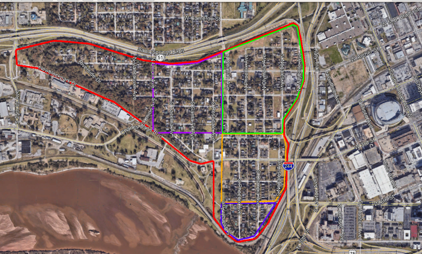
The Crosbie Heights neighborhood is comprised of several early Tulsa subdivisions. Roughly speaking, the neighborhood extends from the west leg of the Inner Dispersal Loop west to 25th West Avenue (Gilcrease Museum Road), and from the Sand Springs Expressway (US 412, US 64, OK 51) south to Charles Page Boulevard and the Arkansas River.
Last fall, property owners in the Crosbie Heights neighborhood started to notice that the value of their property, as determined by the Tulsa County Assessor's Office, had decreased, despite home sales in the area that indicated increasing market value for the neighborhood. Specifically, the value of unimproved land -- what a lot would be worth if there were no building on it -- was cut from as high as $19,563, but typically closer to $7,500, to a nearly uniform $3,000.
Crosbie Heights home owner Fletcher Stewart began to investigate. He and neighbors went through the Tulsa County Assessor's website, tabulating property values for every lot in the four largest subdivisions (Crosbie Heights, Mitchell-Crosbie, Overlook Park, and Owen Addition) in the neighborhood, and saw a disturbing pattern. According to the neighborhood's tabulations, values for 69 of 125 properties in Owen Addition and 6 of 9 properties in Overlook Park subdivision owned by Quapaw Investments LLC dropped to $3,000 in 2018; in 2019 the same drop was applied to nearly every other property in those two subdivisions plus the Crosbie Heights subdivision proper. (Lot values in the southernmost subdivision of the neighborhood, Mitchell-Crosbie, south of 7th Street along Nogales, Olympia, and Phoenix Avenues, were not similarly affected.) Stewart made open-records requests for assessment appeals and verified that Quapaw Investments LLC had protested the assessment on many of its properties in 2018.
On January 1, 2020, KTUL ran a news story on the Crosbie Heights land value situation, talking to Fletcher Stewart, Tulsa County Assessor John Wright, and the Tulsa City Councilor for the neighborhood, Kara Joy McKee.
At the last Tulsa City Council meeting before Christmas, on December 18, 2019, he presented his findings during the untelevised public comments period. He kindly provided me with his prepared remarks to publish here at BatesLine. I'll add some comments and further background info at the end.
My name is Fletcher Stewart, I own my home in Crosbie Heights, which is the neighborhood that immediately borders downtown to the west. It is one of Tulsa's oldest neighborhoods, we have some amazing views of the skyline, and easy walkability to the BOK Center and Tulsa Arts District. I love where I live and wouldn't want to be anywhere else. But according to the City and County, ours is a blighted neighborhood and our homes sit on virtually worthless land. There is a lot of fear among the neighbors about the future of the neighborhood, and the facts I'm going to present will show why those fears are valid.First, I want to bring attention to what has happened to property values, as assessed by the county. In Crosbie Heights, there is a developer who, according to my math, owns about 22 percent of the total lots. In 2018, he protested the land values for dozens of his properties. Regardless of the size of the lot, or the previous land value, the protests he submitted stated the land values should be dropped to $3,000. The assessor's office essentially rubber-stamped agreement to the protests and lowered the values. In 2019, because of the protests filed, this new land value was applied to most of the other properties in the neighborhood, leading to dramatic drops. I compiled a spreadsheet with data from the tax assessor that catalogues the property values over the last three years, and the results are shocking. The land my home sits on dropped in value from $7,600 in 2018 to $3,000 in 2019. I found a property that dropped from $18,000 to $3,000. Over and over and without variation, $3,000 is what the county says our land is worth, regardless of lot size, previous year value, or even if a sale had taken place recently.
I want to emphasize how abnormal this is. I could not find any other neighborhoods in Tulsa County with a similar pattern of land values. In fact, I can say confidently that Crosbie Heights has the lowest average land values anywhere in the county, and I've been looking. I have looked at neighborhoods all over: Turley, West Tulsa, the homes in the Pearl that are facing Eminent Domain. I even searched for news articles to see what neighborhoods had experienced multiple shootings and homicides, and even those had higher land values than our downtown adjacent homes.
The other pressing issue that must be addressed is the Crosbie Heights Blight Study. Without preamble or outreach to the neighbors, the Tulsa Development Authority commissioned the Blight Study. Its stated purpose is not to determine if Crosbie Heights is blighted, but simply to "document blight conditions" on the neighborhood. It concludes, after several pages of images of boarded up houses, that Crosbie Heights is indeed blighted, and "is detrimental to public health, safety, morals and welfare of the city." This study provides no recommendations, nor path to rehabilitate the neighborhood; it just lists and describes the conditions of blight.
Now the term blight carries real weight as a legal term. Being labeled blighted means the city may now exercise Eminent Domain and acquire our homes. With that in mind, just across the highway that separates us from downtown, there is an unprecedented boom in development and vibrancy. The BOK Center, Drillers Stadium and other recent developments brings thousands to the heart of the city. There is so much more planned, the next few years will bring in even more growth to downtown - so why does the vitality end at the IDL?
There has been so much discussion lately about affordable housing in Tulsa. Well that's us - our neighborhood is affordable downtown housing. Why are we the subject of a blight study, and not part of the conversation about affordable housing and our place in it?
Here's the writing on the wall, the extrapolation of the facts I presented, and the reason I'm scared: Over the next few years. Our neighborhood will deteriorate. The falling values will scare off investment, and will make it easy for developers to acquire property, clear the houses on them, and sit on the vacant lots. At some point in the near future a plan will be presented. My guess would be high-rise condos, sold on skyline views and close access to downtown. The city, which has already made the determination the area is blighted, will exercise its power of Eminent Domain to clear the remaining homes- and that will be it. Some people will probably make a bunch of money, but it won't be us, the residents of the neighborhood. We'll lose our homes, and with them, Tulsa will lose another piece of its past.
I'm here to ask the city for help. Publicly disavow the blight study, and make a commitment to the downtown neighborhoods regarding future use of Eminent Domain. Work with us so the booming success of downtown is felt by more Tulsans, and the vitality doesn't just end at the IDL.
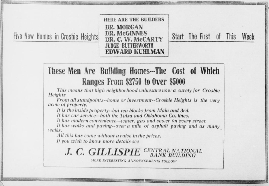
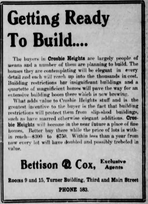
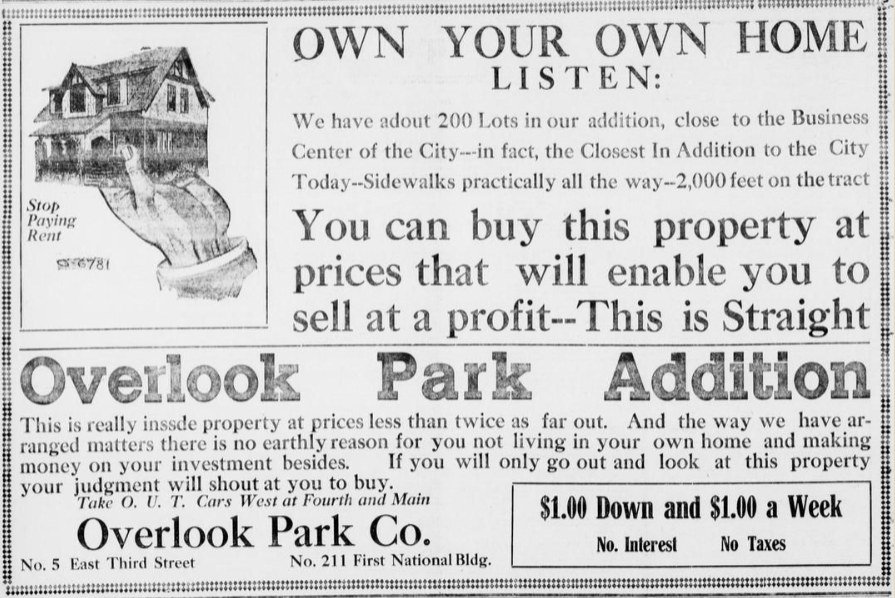
As you can see from the 1908 and 1911 newspaper ads in this entry, these subdivisions were prestigious locations when built. Developers were keen to let the public know that prominent and prosperous members of the public were building homes in the area, and that covenants would ensure that only quality homes were built. Proximity and strong connections to downtown (both streetcar companies and the Sand Springs interurban served the neighborhood) were major selling points. Homes of similar vintage and quality in other Tulsa neighborhoods are under Historic Preservation zoning protection.
As Mr. Stewart notes, in 2018, the Tulsa Development Authority conducted a "blight study" of the Crosbie Heights neighborhood. The blight study turned its survey of resident requests for improvements into a justification for a finding of blight, which would open the door for forcible acquisition by eminent domain. On March 27, 2019, the TDA asked the City Council to ratify its finding of blight, prompting strong protests from residents, which led the City Council not to act on the TDA's recommendations.
Oklahoma has a ridiculously loose definition of blight. Nearly any piece of property could qualify. If a city council makes a finding of blight, the courts generally defer. The Castle Coalition, a project of the Institute for Justice, has given Oklahoma an F for its failure to protect property rights because of this loose definition of blight. Here is the definition in 11 O.S. 38-101, part of the Oklahoma Municipal Code:
"Blighted area" shall mean an area in which there are properties, buildings, or improvements, whether occupied or vacant, whether residential or nonresidential, which by reason of dilapidation, deterioration, age or obsolescence, inadequate provision for ventilation, light, air, sanitation or open spaces; improper subdivision or obsolete platting of land; deterioration or demolition of structures without repair, replacement or reinvestment; improper street layout in terms of existing or projected traffic needs, traffic congestion or lack of parking or terminal facilities needed for existing or proposed land uses in the area, predominance of defective or inadequate street layouts; faulty lot layout in relation to size, adequacy, accessibility or usefulness; insanitary or unsafe conditions, deterioration of site or other improvements; diversity of ownership, tax or special assessment delinquency exceeding the fair value of the land; defective or unusual conditions of title including, but not limited to, highly fragmented interests; any one or combination of such conditions which the municipal governing body determines substantially impairs or arrests the sound growth of the municipality and constitutes a substantial liability, or which endangers life or property by fire or other causes, or is conducive to ill health, transmission of disease, mortality, juvenile delinquency, or crime and by reason thereof, is detrimental to the public health, safety, morals or welfare;
11 O.S. 38-102 makes a legislative finding that condemning a blighted area is a public use, presumably to satisfy Article 2, Section 23, of the Oklahoma Constitution, which limits eminent domain to public use, as opposed to public purpose or public benefit. 11 O.S. 38-103 authorizes a municipality to take blighted properties. 11 O.S. 38-105 requires a municipality's governing body to make a finding of blight before the condemnations can begin. Similar provisions in Title 27, Article 5, govern a county's use of eminent domain.
Although in 2006 the Oklahoma Supreme Court in Board of County Commissioners of Muskogee County v. Lowery (2006 OK 31) affirmed the Oklahoma Constitution's prohibition of condemnation for economic development, a tighter standard than the U. S. Supreme Court applied in Kelo v. New London, they added a qualification that left an enormous loophole, enabling corrupt politicians to continue to seize private property for the benefit of their friends:
We further hold that takings for the purpose of economic development alone (not in connection with the removal of blighted property) do not constitute a public use or public purpose to support the exercise of eminent domain as a matter of Oklahoma constitutional law, nor does it satisfy the public purpose requirement of 27 O.S. 2001 § 5.
This is not the first time that the Crosbie Heights neighborhood has been threatened with eminent domain. Back in 2000, during the second failed attempt to assemble a package of projects that would convince voters to raise taxes for an arena, there was discussion about adding some form of "river development" as a sweetener for voters, and Crosbie Heights south of 3rd Street was targeted for replacement with an entertainment district / amusement park -- "Tulsa's Six Flags," as one proponent called it. Raising a public alarm caused the idea to be shelved.
More about that later, but as I wrote at the time, "It's never too early to stop a bad idea." The bulldozers aren't running yet, the Council hasn't yet acted on the TDA's requested blight declaration, but there are worrying signs that someone is trying to line everything up to clear this historic neighborhood for private redevelopment. We must remain vigilant.
New population estimates indicate that Texas may gain three seats and Florida two seats in the US House of Representatives after next year's US Census, while New York and California may lose a seat each. A handful of other states, mainly in the West and Sun Belt are projected to gain a seat, and a handful, mainly in the Rust Belt, are likely to lose a seat. Oklahoma is projected to keep its five congressional seats.
Shortly before New Year's Day, the US Census Bureau released their estimate of each state's population as of July 1, 2019. This is not the actual enumeration required by the Constitution every ten years for reapportionment of the House of Representatives -- that census will be taken on April 1 this year. This is an estimate based on birth and death statistics, and federal records (e.g., tax returns or Medicare enrollments showing a Social Security number in a different state than previously) which show internal migration. (A 14-page paper about the population estimate methodology may be found on the Census Bureau website.) The recent data release is only for population by state. Over the course of the first half of this year, 2019 population estimates will be released for counties, metropolitan areas, and cities and towns.
Sean Trende, senior elections analyst for RealClearPolitics, has used a weighted average of the rate of growth across the 2017, 2018, and 2019 estimates to project a 2020 population for each state and then applied the Method of Equal Proportions, the method that the US has used since the 1930 census, to calculate congressional apportionment based on his 2020 population projection:
- Gain 3: Texas
- Gain 2: Florida
- Gain 1: North Carolina, Colorado, Arizona, Montana, Oregon
- Lose 1: Alabama, California, Illinois, Minnesota, Michigan, New York, Ohio, Pennsylvania, Rhode Island, West Virginia
The allocation of seats under this method is something like dealing out an entire deck of 435 cards. Each state gets dealt a seat, then the remaining 385 seats are dealt in priority order. A state's priority is calculated as its population divided by the geometric mean of the number of seats it's been dealt and the number of seats if it's dealt one more. In C syntax: priority = population / sqrt ( current_seats * ( current_seats + 1 ) ). As soon as a state is dealt a seat, its priority is recalculated for the next seat. This method produces an ordered list of seat assignments, and so you'll hear analysts talk about which state will get the 435th seat, which states are "on the bubble" to gain or lose seats, depending on small changes in the final, official count. States that are shown by estimates to be in that 430th to 440th seat range have a strong incentive to push their people to respond to the Census.
The ordered nature of passing out seats also means you can estimate the effect of increasing the size of the House, which has been fixed at 435 for over a century (with a brief exception after Alaska and Hawaii joined the union in the late 1950s). Prior to the 2000 census, when Oklahoma was expected to lose a seat after barely keeping its 6th seat in 1990, Congressman Ernest Istook proposed increasing the House by about 30 seats, enough so that no state would lose a seat, but equal proportions would be maintained.
With the size of the US House fixed by law at 435, a state will keep its congressional seats if its population growth keeps pace with the rest of the country. Growing more slowly puts you at risk of losing a seat. Losing population, as Illinois, Vermont, and West Virginia have done, pretty much guarantees the loss of a seat, unless, like Vermont, you're already down to the constitutional minimum of one.
MORE:
Back in December 2010, after the official state counts were released, I wrote a piece about the 2010 reapportionment process, with numerous links to background material.
The website Thirty-Thousand.org advocates for a House of Representatives closer to the Constitutional number of one representative for every 30,000 people. Had the first article of the Bill of Rights been ratified (the other 11 have been), we'd have about 6,000 representatives. The site provides a deep dive on the history of apportionment methods.
Wikipedia has the numbers for apportionment of the US House of Representatives since 1789.