July 2021 Archives
If you went looking for BatesLine recently and found nothing, it's because the server was offline from late Tuesday, July 13, 2021, until sometime Wednesday evening, July 14, 2021. According to BatesLine's hosting provider, the downtime was "due to a MAC address conflict after a chassis swap. However, they were unable to boot the server up by different means. As a last resort, they have restored guests from backup to idle hypervisors." Sounds like a planned upgrade (which we weren't notified about) that encountered a problem that should have been anticipated.
Just before everything went haywire, I added a couple of my old Urban Tulsa Weekly columns to the archives.
As faithful readers will no doubt recall, I wrote the weekly "Cityscope" column for UTW from September 2005 to May 2009. The newspaper ceased publication in November 2013 and the newspaper's web presence vanished shortly thereafter. Unfortunately, the website was set up in a way that was hard for the Internet Archive to navigate, and much of the site's content has been lost.
I kept copies of everything I submitted and retained my rights. (I stopped writing for UTW in May 2009 because I refused to sign the new freelancer's agreement which would have given UTW full "work for hire" rights.) Very slowly, over time, I've been posting those old columns and feature stories here, in the UTW Column Archive category.
Here are the two additions:
A recent essay by Addison Del Mastro calling for shared parking in suburbia prompted me to post my April 29, 2009, column proposing a parking pool for businesses and churches along Cherry Street and outlining a mechanism to make it worthwhile for all concerned.
In November 2008, I wrote a piece linking Thomas Kinkade, "painter of light," to urbanist Christopher Alexander, showing how Kinkade's paintings exemplify many of the patterns that comprise Alexander's Timeless Way of Building.
Although his work may be sold in suburban malls to be hung on suburban walls, the realities of suburban life do not intrude onto Kinkade's canvas.In Kinkade's cityscapes, the townhouses and commercial buildings come up to the sidewalks and have windows that allow passersby to see inside. In his neighborhood scenes, the houses have porches and big windows facing the street.
The buildings have eye-catching details above the windows and along the rooflines. The scale of the buildings and the details are proportionate to the pedestrians passing by. The light is gentle, coming through building windows, from small lights reflecting on the façade or signage, or from subdued streetlights....
Kinkade's paintings sell because they depict places where people want to be, places that are full of life.
But thanks to zoning laws with their setbacks and segregations by use and minimum numbers of parking spaces, thanks to modern commercial building practices and lending practices, thanks to indiscriminate demolition and the lack of conservation ordinances, places like these are harder and harder to come by.
And so instead of inspiring in their suburban owners the hope of living in such a place, these paintings embody a bittersweet nostalgia for the kind of streets that, they have been led to believe, can not exist in the modern world. Oh, maybe in a big city on the east coast, or over in Europe, but not in a sprawling Sun Belt metropolis like Tulsa....
Imagine that Tulsa could be so beautiful and full of life that people who had never been here would hang paintings of our streetscapes on their walls and dream of someday coming here.
More to come, eventually.
Newspapers.com has some amazing content that can help to locate long-lost rural places around Tulsa. I was searching for information about Bethel Union School, later known as Paul Revere School (which I wrote about in conjunction with the centennial of Southern Hills Baptist Church), and I found a legal notice in the November 14, 1946, edition of Tulsa's Farm and Garden newspaper. The notice from the Tulsa County Board of Commissioners announced a bond issue election on December 17, 1946.
The election included two propositions. The first was to borrow $280,000 to build a bridge across the Arkansas River at Jenks. The bond, to be repaid over 20 years, was estimated to cost taxpayers a total of $530,000. The bridge, consisting of 19 pony trusses, was completed in 1948 and still stands, but open to pedestrians only since the new Jenks bridge opened in 1995. On the same ballot was a $1,250,000 bond issue to build a 200-bed county hospital.
The morning after the election the Bartlesville Examiner reported unofficial results with 181 precincts out of 190 reporting: The county hospital was defeated 3,006 (34.6%) to 5,690. The Jenks bridge was approved 7,246 (73.2%) to 2,652. The hospital issue had a significant amount of undervotes: 1202, or 12.1% of people who voted on the bridge question didn't vote on the hospital question. Opposition to the hospital focused on the ongoing cost of operation. A letter to the editor in the Tulsa Tribune (reprinted by the Collinsville News) pointed out that the city already owned the old Morningside Hospital building at 502 N. Boulder and could fit it out for 40 beds. Local government could pay private hospitals to take any additional indigent patients more economically than building and running a new facility.
In the state general election on November 5, 1946, 60,593 Tulsa County ballots were cast for the top two candidates (40,734 for Republican Olney Flynn, 19,859 for Democrat Roy Turner, who won statewide), so the special county bond election a month later and just a week and a day before Christmas had only a sixth of the turnout.
The legal notice for the December election listed all of the 138 precincts in the City of Tulsa on one page and the 52 precincts in the small towns and rural townships on the next, giving the name of the place, the address, the election judge, and the two election clerks. It's remarkable to see how many polling places were set up in homes.
In the list you'll find names of schools long demolished (e.g., Whittier, Jefferson, Dunbar, old BTW, Mingo, Paul Revere, Plainview) or renamed (e.g., Lee, Cleveland, Sequoyah, Roosevelt) and many other forgotten places, like the Rainbow Inn on North Peoria, somewhere between 66th and 126th Streets North.
The 52 rural precincts (all except for those in the towns of Sand Springs and Broken Arrow) are named after civil townships. Some precincts voted at locations lost to time: Dawson Precinct No. 7 voted at the Twin Oaks Filling Station; Frye Precinct No. 1 voted at the home of Mrs. Bessie Wade, 1 mile north of Kramer corner, wherever that was. Willow Springs citizens voted at the White Church, on 129th East Ave south of 121st Street. Some of the Lynn Lane polling places were right on the southeast edge of Tulsa's growth -- Paul Revere School at 51st & Lewis, the Fairgrounds Administration Building, the Tulsa Tennis Club at 28th & Columbia, a house at 1305 S. Memorial, Tulsa Lumber Company at 4112 S. Peoria, Crowell Heights Baptist Church, and Plainview School, shown on a 1914 USGS topographical map as on the north side of 11th Street between Garnett and 129th East Ave.
Civil townships are county subdivisions, exclusive of incorporated cities and towns, that had a governmental role for a few years after statehood, but township offices were abolished by all of the counties by the end of the 1930s, although they continued to provide a structure for census districts and voting precincts. Some civil townships share a name with an incorporated municipality (Owasso, Skiatook, Collinsville, Red Fork, Dawson, Bixby, Jenks, Glenpool) and some do not (Wekiwa, Lynn Lane, Fry, Boles, Willow Springs). In Tulsa County, civil township boundaries mainly followed cadastral township boundaries and the Arkansas River.
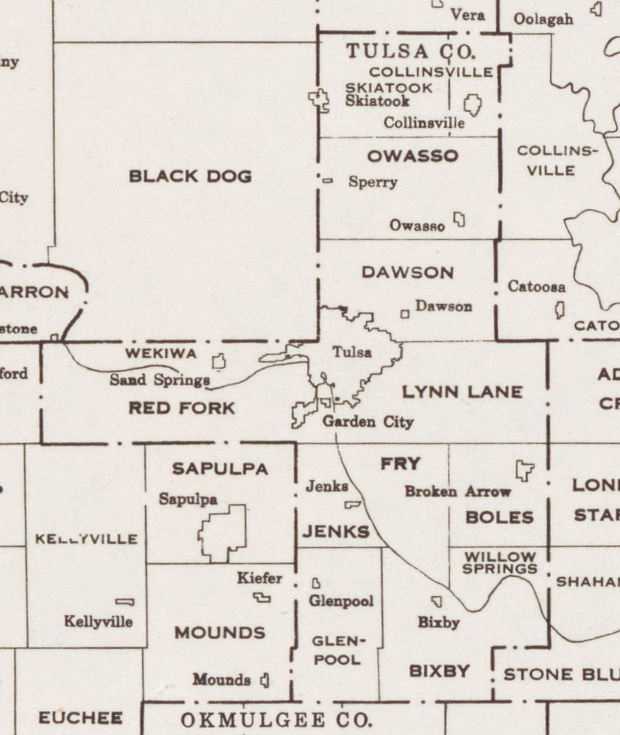 Tulsa County, from "Oklahoma Minor Civil Divisions and Townships," U. S. Census Bureau, 1941
From north to south:
- 186th St N to 126th St N: Skiatook township (W of Mingo); Collinsville township (E of Mingo)
- 126th St N to 66th St N: Owasso township
- 66th St N to Archer St: Dawson township
- Edison St / Archer St to 61st St S: Red Fork township (SW of the river), Wekiwa township (N of river, W of Tulsa), Lynn Lane township (E of river and Tulsa)
- 61st St S to 121st St S: Jenks township (W of river), Fry township (N and E of river, W of Mingo Rd), Boles township (E of Mingo Rd)
- 121st St S to 211th St S: Glenpool township (W of Harvard), Willow Springs township (E of Mingo, N of River), Bixby township (E of Harvard, S of river)
The 1955 Tulsa County Highway Map shows the township names and boundaries in greater detail.
Here are links to Newspapers.com clips of the 1946 Tulsa County precinct list. At some point, I hope to convert the information to a KML file, so it can be displayed as a map overlay.