Maps: May 2009 Archives
 Too tired tonight to do much more than link. I've been working on a post about the Oklahoma City Union Station rail yard / I-40 relocation controversy, but it's not ready. For now, here are links to some maps and other information about the history of the state's rail network, from most recent to oldest:
From the Oklahoma Department of Transportation's website. (Note how much of the network is owned by ODOT and leased to various railroads, including the entire Frisco route from Tulsa to Oklahoma City.)
- Oklahoma 2009 railroad map
- Oklahoma 2009 railroad map - reverse showing city detail
- Oklahoma Centennial 2007 railroad map
University of Alabama collection of historical Oklahoma maps. The browser is annoying, and you can't download high res copies, but there's some very interesting material here, including:
- A 1921 Rand McNally state map with railroads and interurbans, with more interurban station names
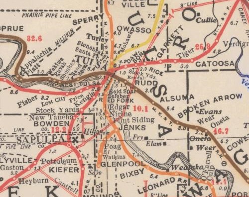
- 1917 Corporation Commission map of railroads and pipelines: The Tulsa County section is shown above
Note the interurbans connecting Bartlesville to Dewey, Nowata to Coffeyville, Oklahoma City to Norman, El Reno, and Guthrie, Lawton to Ft. Sill, McAlester to Hartshorne, Shawnee to Tecumseh, and Miami to the rest of the Tristate mining region. As far as I can tell, only Tulsa's interurban lines -- Sand Springs and Tulsa-Sapulpa Union (originally the Oklahoma Union Traction Ry.) -- remain in operation, as freight-only short lines.
OkGenWeb's 1915 state map with a list of railroad names and abbreviations -- high res scan
Doug Loudenback's high res scan of a 1905 map and gazetteer of the Twin Territories, with Doug's observations. The original: 1905 Premier series map of Oklahoma and Indian Territory (Library of Congress)
UPDATED 2023/12/29 to fix broken links to the University of Alabama map archive and to update the okgenweb.org link to point to okgenweb.net