Oklahoma Weather Category
The Tulsa Area Emergency Management Authority (TAEMA) has issued an advisory and a map showing the areas at risk of flooding as Keystone Dam release rates increase.
Here is the full text of the advisory:
(TULSA, OK) - This morning, The Army Corps of Engineers announced it would be releasing 215,000 cubic feet per second at 10 a.m. and releasing 250,000 cubic feet per second beginning at noon with the expectation of leaving it at this rate for four days.The updated maps for the 250,000 release level and for planning purposes of 305,000 cubic feet per seconds can be found at www.cityoftulsa.org/rivermaps
For planning purposes, the City of Tulsa has already been planning for historic flooding levels that Tulsa experienced in 1986, when Keystone Dam release levels reached over 300,000 cubic feet per second.
Due to the additional release at Keystone Dam, flood water is expected to steadily rise and residents and businesses along the Arkansas River need to remain vigilant and take precautions. Based on the release rates at noon, Sand Springs and the western part of Tulsa County is expected to see the first impact in approximately two hours and central Tulsa approximately four to six hours and south Tulsa County in approximately eight to 10 hours.
It is recommended residents living in affected neighborhoods along the Arkansas River and in a 100-year floodplain should:
- Prepare immediately for evacuations.
- If you leave your home, take all electric precautions by switching off the main breaker to electricity and disconnect any emergency power system, like generators.
- Have a packed bag with prescriptions and clothing for a multiple-day period
- Charge your cell phones and place them in low-power mode, put valuables in a higher place, bring your pets with you
- Leave your home with important identification for you and any members of your family and take videos/pictures of your home for insurance purposes
- If you are an evacuee or someone you know is evacuated and requires home health care and/or in-home hospice care, you need to let your health care agency know where you are sheltering so you can continue to receive services.
- It is important to have a two-week supply of prescription medication on hand and ready if/when you evacuated. In addition, have copies of all prescription medication with dosage, prescribing doctor, and pharmacy. This includes mental health medications. Communicate this message with those in your life who may need assistance with this.
- Communicate with members of your family who need to take these precautions but have physical limitations that may prevent them from doing so.
- For safety's sake, assume that any downed utility line is energized with deadly electric current. Stay away from the line and do not touch it with anything. Report it to PSO at 1-888-218-3919.
- Please do not approach crews and utility vehicles you see in your neighborhood to ask when power will be restored. Doing so could jeopardize your safety. Outward vision from the large utility vehicles can be limited. A crew may not see someone who has walked up to their work truck.
Once evacuated, residents might not be able to get back to evacuated areas for a week or longer. All residents in Tulsa County with questions or concerns related to this flooding event or evacuations can call 211, 24/7. 211 will also be equipped to take damage assessments and answer questions about donations to those affected by these floods.
As of 10:30 a.m. Thursday, there is an evacuation shelter at Crosstown Church of Christ, 3400 E. Admiral Place and Tulsa Animal Welfare advises those with ADA service animals can take them to this location. All other pets can go to the temporary shelter at Tulsa Expo Square Fairground Pavilion (south entrance) from 8 a.m. - 8 p.m. The temporary pet shelter at the Fairground is accepting pet food, blankets and towels.
The Red Cross is currently working on setting up additional shelters in other areas of Tulsa County that will be impacted by flooding. As soon as those shelters are operational, a media advisory will be issued. At 3 p.m. today, Tulsa Area Emergency Management Agency (TAEMA) will begin sounding the flood alarm. The alarm will sound every 30 minutes for six hours. For those who hear the alarm, (https://www.cityoftulsa.org/residents/public-safety/emergency-sirens/) it is an indication they need to be aware of the flooding conditions and take appropriate precautions.
Residents should go indoors and tune to local media to seek more information. It is highly recommended that all people who live near the Arkansas River pay attention to local news coverage, listen to weather radios, be observant of local weather apps, and seek higher ground if necessary. Please stay out of the water and relocate to a safe location.
Follow the City of Tulsa on Twitter @cityoftulsagov and visit www.cityoftulsa.org for updates.
The map below is a screen capture, showing the Arkansas River from 21st to 61st Street, from this interactive map depicting estimated flooding depths at a Keystone Dam release rate of 305,000 cubic feet per second (cfs), with colors indicating maximum depth. Blue is less than 1 ft., aqua is 1-2 ft., green is 2-3 ft., yellow 3-4 ft., brown is more than ft. The city has released PDFs has detailed images showing the forecast flooding for Keystone release rate of 250,000 cubic feet per second, and forecast flooding for 305,000 cubic feet per second. Please note that this map applies to a 20% higher rate of release than is currently underway.
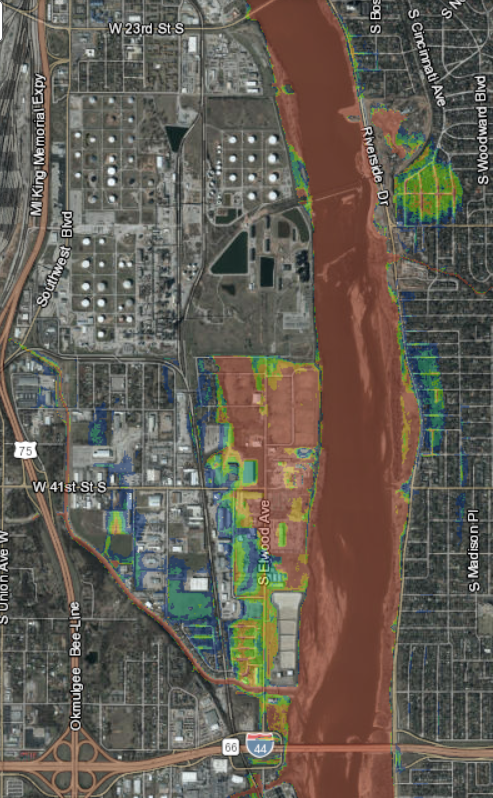
As of 4:30 pm on Thursday, May 23, 2019, the release rate from Keystone Dam is 249,000 cfs. The intake rate from upstream is 280,000 cfs. The lake elevation is at 754.3 ft. above seal level, just a few inches above the flood control pool level, and about 17 feet below the top of the dam.
MORE:
Wednesday evening two barges carrying fertilizer broke loose at the Port of Muskogee. Because of the strong current, tugs could not be used to corral the barges. They missed hitting the supports for the US 62 bridge over the Arkansas River, but there were fears that they would hit and destroy the Webbers Falls lock and dam. The town was evacuated and the I-40 bridge -- the replacement for the bridge destroyed by a barge collision in 2002 -- was closed to traffic. Morning revealed that the barges had hung up on some submerged rocks, but they floated free again, striking the dam. The barges broke up and capsized within a couple of minutes.
If you're concerned about flooding potential in the Muskogee / Fort Gibson / Three Forks area, Jamison Faught has maps.
Speaking of Muskogee, the USS Batfish may soon be able to descend to periscope depth:
NewsOn6.com - Tulsa, OK - News, Weather, Video and Sports - KOTV.com |