Tulsa History: June 2018 Archives
Mapping Tulsa, a diverse collection of historical maps illustrating Tulsa's history and culture, is on display at the Henry Zarrow Center gallery, at the southwest corner of Brady Street and Cincinnati Avenue in Tulsa's Bob Wills Arts District. The gallery is open noon to 6 pm on Thursdays, Fridays, and Saturdays, and the Mapping Tulsa exhibit runs through June 30, 2018.
I went to see it last Saturday with my youngest son, who has inherited his dad's fascination with maps. While many of the maps were familiar from online collections, there were a few I had never seen before, and it was fun to be able to look at them together in a large format and discuss the interesting details we found. Here's a list in roughly chronological order, with a few of those details.
- 1804, Tanner-Arrowsmith Map of Louisiana
- 1830-1840, Routes of Emigrating Indians: 1932 map showing Trail of Tears routes from the southeastern US to Indian Territory, compiled by Grant Foreman and traced by George Bystrom
- 1866, Indian Territory: Highlights effect of post-Civil War treaties with the tribes that fought alongside the Confederacy.
- 1890, Map of Indian Territory and Oklahoma: Showing railroads, trails, tribal boundaries, treaty dates. Oklahoma is shown as everything west of the Five Tribes territories, except that the Panhandle is not included, and labeled as "Public Lands."
- 1898, USGS Fractional Survey Township Plat, T19N, R12E: Covers 81st West Ave to Peoria, Osage County Line to 61st Street. Shows the newly incorporated boundaries of Tulsa, parcels and acreages, slopes, wooded areas, cultivated fields, and creeks that have long been channeled into storm sewers.
- 1901, Map Showing Progress of Allotment in Creek Nation : Shows division into townships and sections, shaded lands that had been allotted already, railroads, townsites, agencies, and tribal facilities.
- 1901, Tulsa Town Site Map: 1944 republication in honor of Tulsa's incorporators and in memory of surveyor Gus Patton. Shows original townsite (654.48 acres) and municipal limits (1440 acres, or 2.25 square miles) at incorporation.
- Circa 1901, Section 9 of T15N, R18E: "SECTION DIAGRAM: Showing irregular form of present land holdings of Creek citizens as surveyed and platted by the Commission to the Five Civilized Tribes preparatory to allotment." Fields on the diagram belong to people with the last name Rentie, Spaulding, Van, Mackey, and Sango. Fences, buildings, roads, and timbered areas are plotted on a grid of 0.4 acre squares (132 feet by 132 feet, or two chains by two chains).
- 1905, State of Sequoyah: Shows proposed county boundaries on a 1902 USGS base map.
- Civic Center / Union Station proposal, probably from the 1910s: Bird's eye-view of a proposed Beaux Arts Civic Center, in the fashion of Chicago's Midway or the National Mall, which would have occupied the blocks between Archer and Cameron, Main and Cincinnati, with a Union Station north of Cameron Street, and the rail tracks running approximately where the old MK&T tracks were, what would have been Davenport Street. The Civic Center would have included a public library, federal, county, and municipal buildings, municipal auditorium, and hall of records surrounding a plaza with a tall obelisk atop a museum or memorial.
- 1918, Fowler and Kelly bird's eye map of Tulsa
- 1920, Sanborn Fire Insurance Map, Tulsa, Sheet 9: Shows the heart of Tulsa's African-American district, Greenwood and Frankfort Avenues from Archer to Easton Streets, prior to its burning by a white mob in 1921. The color image highlights the pasted segments, used to update the map to show recent construction.
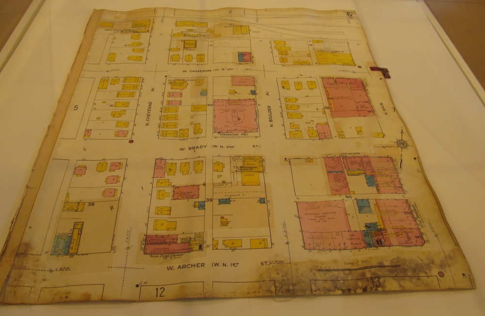
- 1920, Sanborn Fire Insurance Map, Tulsa, Sheet 6: Shows Archer to the MK&T tracks, Cheyenne to Main. This is an actual page from the atlas, under glass. Not only can you easily see the pasted segments with recent construction, but if you look carefully, you can see what was there before, showing through the new layer.
- 1921, Art Work of Oklahoma's Oil Cities: On display are photos of the Arkansas River and the University of Tulsa campus.
- Before 1924, Spavinaw water system: A mosaic of three USGS quadrangle maps (Hominy, Claremore, Pryor), with the route of the water pipeline drawn over it, along with the High Pressure Reservoir on Reservoir Hill, Mohawk Reservoir, and the Tiawah Tunnel. What's fascinating is that the Hominy and Claremore quadrangles are from 1916, so they show the influence of quarter-section allotment on the road network. The Pryor quadrangle is from 1901; its roads follow the terrain. Many long-gone rural schools are shown on this map.
- 1928, Tulsa and Northeast Oklahoma promotional map, Tulsa Chamber of Commerce: Shows Tulsa at the intersection of "Three Great Highways" (US 64, US 66, US 75), major city streets and highways, roads of northeastern Oklahoma, and articles touting the region's virtues.
- 1936, WPA map of land ownership, Tulsa County, T19N, R13E: This map, one of a statewide series documenting owners and property values during the Great Depression, shows the 6 mile by 6 mile township between Peoria Avenue and Mingo Roads, Archer and 61st Streets. There are a number of well known Tulsa names on the map: Waite Phillips, Rachel Perryman, P. J. Hurley, Francis A. Rooney. Tulsa County already owned the land that would become LaFortune Park, and a Catholic convent owned 80 acres NW of 51st and Yale. The city limits stopped at 41st to the south and Hudson to the east.
- Circa 1936, Triangle Blue Print and Supply Map of the City of Tulsa: Municipal boundaries are almost identical to the WPA map. This large map shows all streets and covers 81st West Ave to Memorial, 36th Street North to 61st Street, including many rural subdivisions. Red lines, mostly along major streets, aren't explained -- bus lines perhaps? A small Rand McNally pocket map of Oklahoma is on display in the same case.
- 1941, General Highway Map, Tulsa County: Shows numbered highways, municipal boundaries, rural school locations, and county road conditions.
- 1989, INCOG map of Tulsa Metro Area Average Daily Traffic Counts
- 1996, Tulsa Commemorative Character Map, World Graphics Map Company: Map is a cartoonish birds' eye view showing businesses that purchased the chance to be represented on the map. Remember Crystal's Pizza, the Browsery on 11th east of Harvard, Geo's Jumbo Burgers in the old Circle K at 15th and Sheridan, or the Billy Ray's BBQ location down the street in an old Der Wienerschnitzel A-frame building? They're all represented here.
- 2006, The Channels: Artist's conception of the Bing Thom / Warren family $700 million proposal to build islands with high rises in the middle of the Arkansas River north of 21st Street.
- 2017, Mending a Rift: Urbanism for North Tulsa: Maps and illustrations of a master plan for Greenwood and the demolished Near Northside neighborhood, developed by urban planning students from the University of Notre Dame, proposing to restore the urban street grid with dense, pedestrian scale development.
- 2018, Gathering Place map
Several maps deal with the oil and gas industry:
- 1956, Tectonic Map of Oklahoma
- Map of Glenn Oil and Gas Pool and Vicinity
- Locations of All Known or Reported Oil Wells, Gas Wells, and Dry Holes Drilled in Tulsa County: Also includes adjacent sections of Creek, Osage, Pawnee, Rogers, and Wagoner Counties.