Tulsa History: November 2025 Archives
A place that seemed mysterious, mythical to me as a 10-year-old has been in the news lately. What was empty land back then (and still is, half a century later) may become a massive 10-square-mile master planned development with an adjacent data center.
It was 1974. I remember when I first saw it, and I was fascinated.
Our family lived in a little house in Rolling Hills, a subdivision in northwest Wagoner County, unincorporated at that time. Maps of Tulsa didn't show our neighborhood. City insets on road maps were sized for "Tulsa proper," the city limits prior to the massive 1966 annexation which tripled the city's land area and took Tulsa's eastern boundary to the Wagoner County line. A typical city map stopped at Garnett or 129th East Avenue. As a map nerd, I was frustrated that my neighborhood and its environs were treated by cartographers as terra incognita.
 I was 10 when I got a copy of the 1974 edition of the Oklahoma state highway map. I probably picked it up at the Tulsa State Fair, along with a bagful of other brochures and bumper stickers to be found at the booths in the IPE Building. The Oklahoma Department of Highways (now ODOT) issued a state map every year, and there were all sorts of fascinating details that Rand McNally didn't show -- little towns, unincorporated communities, wildlife refuges, city limits of small cities, and Sandstone Creek ("World's First Upstream Flood Prevention Project"). On the cover was a photo of the Nellie Johnstone, Oklahoma's first commercial oil well; when we lived in Bartlesville we walked past the oil well replica often on our way to the swings at Johnstone Park.
The back of the 1974 Oklahoma map was themed "Highways to History" and filled with black-and-white photos of land runs, Indians, chuck wagons, and Will Rogers. There were inset maps for Oklahoma City and Tulsa, and this time the Tulsa map showed all of Tulsa, along with towns to the west and the east and the fence lines they'd established to defend against further Tulsa expansion. Our neighborhood was there! There was Catoosa, there were the old roads we took to get to the port and Owasso, along with the new port highway under construction. And there, on the east edge of the map, coming with a mile of our house, was a big, gray, blocky tornado, stretching from Apache to 66th Street south, from 201st East Ave east beyond the edge of the map labeled Fair Oaks. The Wagoner County map from around that time showed Fair Oaks stretching all the way to 313th East Avenue, a half-mile from the Verdigris River. Stretching 7 miles east to west and 8.5 miles north to south, Fair Oaks' land area was bigger than any other city on the map except Tulsa itself -- bigger than Broken Arrow, Sand Springs, and Sapulpa. According to the index on the other side, in the 1970 census, the massive municipality of Fair Oaks had a population of... 23. 23 residents over 15.2 square miles, possibly the least dense municipality in the USA.

Part of the area covered by Fair Oaks was familiar to us. We drove east on Highway 33 (Admiral Blvd) a few times a year to visit grandparents in Mountain Home, Arkansas. Families from our church had moved from Rolling Hills to build homes on bigger lots near a little store and gas station near Midway Road (257th East Ave) and Admiral (I remember it as Nuckolls' Store, but it was also Fugate's and Tramel's), and we'd go out to visit once in a while; that area wasn't in Fair Oaks, but it was surrounded by Fair Oaks. No one had heard of Fair Oaks. Despite the big footprint, Fair Oaks seemed to have no foothold in tangible reality.

Thanks to online map and newspaper archives, we can reconstruct the early story of Fair Oaks:
Older county highway maps (like this 1936 Wagoner County map) show mining sites roughly running north-south along Evans Road (225th East Ave, two miles east of the Tulsa County line). The Croweburg coal formation, illustrated in this 1982 Oklahoma Geological Survey map of potentially strippable coal beds in eastern Oklahoma, surfaces along a line from about Admiral and 241st East Avenue running south-southwest to 91st Street and 209th East Avenue.
This 1927 Wagoner County production map shows a significant amount of natural gas exploration in the area as well (along with the location of a number of long-lost communities and railroad spurs).
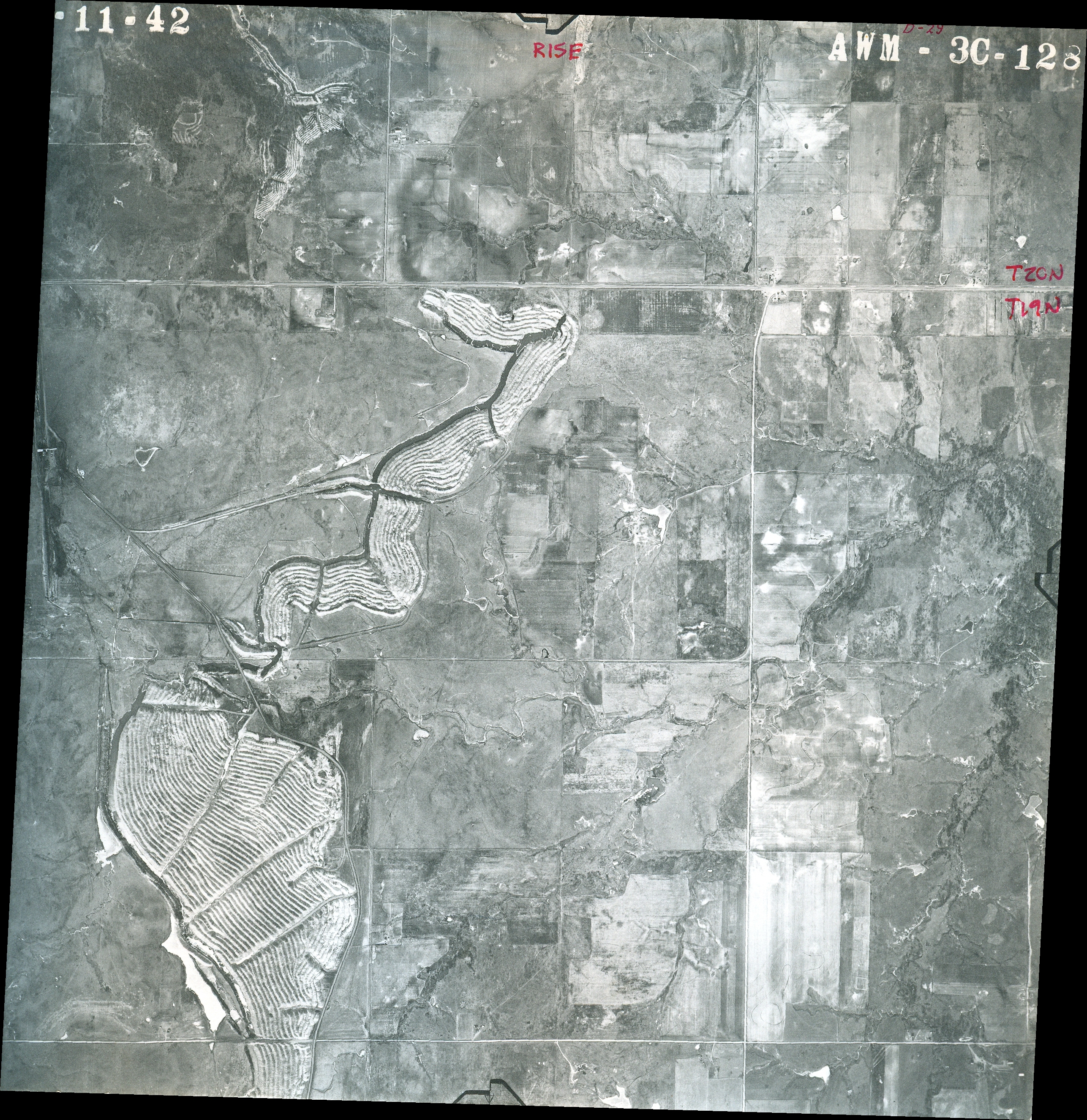
Aerial photographs going back to 1941 show the scars of coal mining, like this photo covering Pine to 21st Street, Evans Rd (225th East Ave) to Oak Grove Road (273rd East Ave). The long thin lakes visible throughout this area on satellite imagery are old coal strip mines that have filled with water.
This 1974 map of surface-mined coal lands shows thousands of acres in the Fair Oaks area disturbed and only a small portion near Catoosa partially or fully reclaimed.
Property ownership maps from 1936 (see also here) showed that much of the future Fair Oaks footprint in Wagoner County was owned by rancher L. S. Robson. Interestingly, the Robson name doesn't show up in newspaper clips about the town until 1999.
On Thursday, August 26, 1966, two new Wagoner County towns filed for incorporation: Oak Grove, a few acres around an existing community centered on a church, a store, and a cemetery at 51st Street and 273rd East Avenue (Oak Grove Road); and Fair Oaks, inaccurately described in news accounts as "6 miles east of the County Line on 71st Street." A 1972 survey showing the Fair Oaks town limits show the original townsite as a quarter-mile-wide L shape with the lower left corner at 11th and Oak Grove Road, about 222 acres. From what I recall of municipal incorporation law back then, you had to be at least so many miles (perhaps five) from an existing city limit in order to incorporate -- this was to discourage the creation of enclaves and the multiplication of municipal governments that would strangle the growth of existing cities and towns. But once you incorporated, you could annex land that would bring you near or up to the boundaries of other cities.
Protecting future mining from being regulated by an expansionist City of Tulsa would have been a strong reason to incorporate Fair Oaks, although none of the newspaper accounts I've read have mentioned coal mining at all. The timing is interesting: Tulsa's big annexation took effect March 25, 1966, and these new towns were created just five months later.
In 1968, City of Tulsa officials were planning for a third airport (after Tulsa International and Riverside), somewhere on the east side of the metro area, which was the direction of growth at that time. The Tulsa Airport Authority's consulting engineer identified five possible site, and in November 1968 recommended an 1,100 acre site in Wagoner County, roughly around 11th Street and 225th East Ave (Evans Rd), likely including land owned by the Robson family. TAA voted in December to accept the recommendation.
By the time the TAA met on February 4, 1969, it was known that Fair Oaks would soon be annexing a massive amount of land, including the TAA's preferred third-airport site. At that meeting, Cal Tinney offered the Tulsa Airport Authority nearly three square miles in Wagoner County for the third airport. Tinney's land was between 31st and 51st Street, County Line Road to 215th East Ave.
On February 8, 1969, the Fair Oaks town trustees approved Ordinance No. 1, expanding the town from 222 acres to over 15,000 acres, and extending west toward Tulsa, north into Rogers County, and south toward Broken Arrow. The Tulsa World story at the time inaccurately described the land as six miles west of the Will Rogers Turnpike entrance. The report stated:
With its growth, the town inherited a private trash pit near Oklahoma 33, a gasoline war raging along the same highway and varying numbers of unlicensed dogs running loose. The annexation proceeding took place at the ranch home of Mrs. Marie Steely, a widow. She and her brother-in-law, Ralph Steely, and a farmer neighbor, W. W. Repschlaeger, are the town's trustees. They passed a motion to annex in response to a petition signed by 15 property owners.In the words of the town's attorney, Sam Bassman of Claremore, "Fair Oaks has as much right to annex property as any incorporated community in the state."
The report said that it was unknown what effect annexation into a different municipality would have on Tulsa's proposed airport plans. Fair Oaks could choose to ban airports or impose impossible regulations.
Tulsa taxpayers rendered the issue moot: A city bond issue proposal for $1,125,000 to purchase land for the third airport was one of 16 out of 18 city and county bond questions that were defeated in a September 9, 1969, election. Only 31.2% of voters supported the measure.
23 was the population of the expanded Fair Oaks in the 1970 census. By 1980, the population had grown to 384, and by the 1990 census had grown to 1,133, living in 382 households. According to the U. S. Census Bureau, the town's total area in 1990 (as it had been since 1969) was 15.2 sq. mi. -- 12.0 sq. mi. in Wagoner County and the remainder in Rogers County.
For all that land, and despite some highway frontage, Fair Oaks had no retail stores to generate sales tax and offered no municipal services.
While none of the news stories to this point have mentioned the Robson family, this June 1969 map showing land ownership around the Port of Catoosa and the McLellan-Kerr Navigation System shows that most of the land within the boundaries of Fair Oaks are owned by "Nick Robson, et al." Owners listed on the original townsite were L. W. Steely, Nick Robson et al., and Walter Repschlaeger, Jr.
Nick Robson's October 1999 obituary says, "Robson was a principal in the organization of the Konklin Volunteer Fire Department, the organization of Wagoner County Water District No. 3 and in the formation of the town of Fair Oaks, serving as the town's clerk." It also mentioned that the ranch had been established in the 1920s by his father, L. S. Robson. The "et al." may have been other Robson family members, such as Nick's sister Helen Robson Walton, wife of Walmart founder Sam Walton.
A March 1975 document posted on an anti-MPD-6 Facebook group shows Catoosa coal magnate Frank McNabb (namesake of the Catoosa High School stadium) leasing mineral rights for up to 10 years to a list of 14 Robsons and Waltons, including Nick Robson and Sam and Helen Walton. The lease covered 4 square miles, Admiral to 31st, Evans to Oneta Roads, and Admiral to 11th, Oneta Road to Midway Road.
It was a few months before Nick Robson's death, in May 1999, that the prospect of industrial development prompted the Robson family and City of Tulsa leaders to begin talking publicly about Tulsa annexing part of Fair Oaks. We will pick up the story there next time.
MORE:
The proposed Fair Oaks Master Planned Development (MPD-6) would transform 6,229 acres of undeveloped land in the Wagoner County portion of the City of Tulsa. This is separate from, but adjacent to, the controversial 339-acre Project Anthem data center south of 11th Street and just west of the Creek Turnpike. MPD-6, a proposed zoning change, was discussed by the Tulsa Metropolitan Area Planning Commission (TMAPC) at their November 5, 2025, meeting, but the applicant asked for a continuance to January 7, 2026. Stay tuned.
Plate 2 of Oklahoma Geological Survey map 33 shows the coal fields of Wagoner County in more detail. Click here, then enter "Geologic Map 33" in the search bar to see all five plates and the accompanying report, covering coal geology in Tulsa, Washington, and Wagoner Counties.
About "gasoline wars": Before the 1973 Arab oil crisis, service stations fought for customers by slashing the price of gas as a loss-leader. Repairs and oil changes were where the real money was to be made. But none of the stations along 33 were within the Fair Oaks town limits.