Tulsa History: November 2026 Archives
There's a big party in downtown Tulsa today, but it's not just Route 66's centennial.
November 11, 2026, is the 100th anniversary of the adoption of the US national highway numbering system. The bulk of the national network of US highways came into being on that day.
The United States System of Highways uses odd numbers for north-south routes and even numbers for east-west routes. In general, numbers increase as you go from north to south and from east to west. Numbers ending in 0 were originally Atlantic-to-Pacific highways, and numbers ending in 1 tended to stretch from northern border to southern border, with US 1 following the Atlantic Coast from Maine's border with Canada to Key West, Florida, and US 101 hugging the Pacific Coast from Canada to Mexico. Three-digit numbers were designated for subsidiary routes to mainline roads, e.g. US 266 was a tributary to US 66. When the Interstate Highway System was laid out in 1957, they kept the same odd-even distinction and the same use of two-digit mainline and three-digit branch roads, but they reversed the numbering order to run from south to north and west to east.
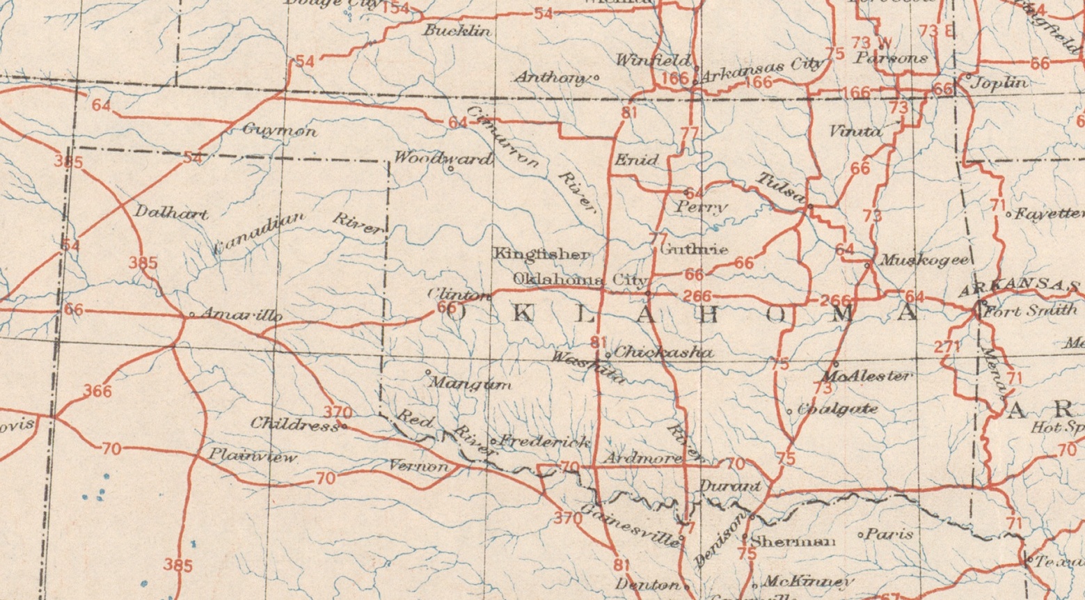
Of US highways passing through Oklahoma in 1926, US 54, US 64, US 70, US 75, US 77, and US 81, plus supplementary routes US 266 and US 271, all share that birthday, and all are still officially with us.
One more north-south route, US 73, passed through Oklahoma in 1926, crossing the Kansas border north of Welch, generally following the route of the Jefferson Highway, and passing through Vinita, Muskogee, and McAlester to its terminus at 2nd and California in Atoka. In 1935, US 73 was terminated at Kansas City, Kansas, and its route to the south was renumbered as a continuation of US 69.
The Oklahoma section (above) of that original 1926 map is pretty sparse. Since then, Oklahoma has been granted portions of US 56, US 59, US 60, US 62, US 83, supplementary routes US 169, US 177, US 183, US 270, US 277, US 281, US 283, US 287, US 377, US 385. Then there's US 412, the number that breaks all the rules, approved in the 1980s to give a common designation to a road that linked Tulsa to northwest and north-central Arkansas to the east.
November 11, 1926, is the date that the American Association of State Highway Officials (AASHO), at their annual meeting in Pinehurst, N.C., adopted a plan for uniform marking of cross-country highways, the culmination of two years of discussion.
In the early days of long-distance automotive travel, private highway associations organized to promote automobile travel and road improvements, designated auto trails and marked them with distinctive paint blazes on telephone poles and fence posts, obelisks, and other creative markers to guide travelers. Blue Books provided turn-by-turn instructions, referring to landmarks that might or might not still exist. Some highway associations authorized multiple routes under the same name, not wishing to favor one town over another. A town might lose its place on a named trail because another town offered more money to the promoters.
Famous long-distance named highways included the Lincoln Highway, the Ozark Trail, the National Old Trails Road (paralleling the National Road and Santa Fe Trail and featuring a Madonna of the Trail monument in each state it passed through), the multiple-branched Dixie Highway connecting the Great Lakes to Florida, and the north-south Jefferson Highway, connecting Winnipeg, Manitoba, to New Orleans. This 1922 national map by Cram shows the Ozark Trail (40), Jefferson Highway (25), King of Trails (27), Albert Pike Highway (2), Meridian Highway (31), Southwest Trail, Atlantic-Pacific Highway (5), and Dallas-Canadian-Denver Highway (15) passing through Oklahoma. A surviving obelisk marking the Ozark Trail stands west of Stroud.
Boosterism, hucksterism, inconsistency, misrepresentation, and duplication led states to begin attaching official designations and standardized markings, beginning with Wisconsin in 1918. In 1924, Oklahoma established a numbered state highway system.
This 1997 article by Richard F. Weingroff of the Federal Highway Administration provides a detailed account of the problems leading to the decision to establish of a uniform national highway numbering system and the 18-month process to agree on routes and numbers. Weingroff's account includes the contentious debate over the designation for the Chicago to Los Angeles highway, with Oklahoma's Cyrus Avery fighting Kentucky for the rights to US 60, a round number befitting an ocean-to-ocean route, before concluding that US 66 would be a fine alternative and preferable to US 62.
(Weingroff notes that Avery was not in office to see the realization of his vision. New Governor Henry Johnston fired him after taking office in January 1927.)
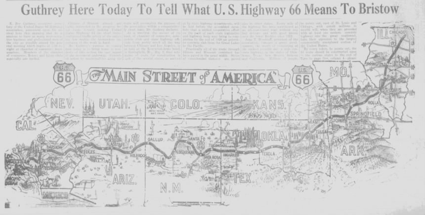
A national numbering system did not kill highway boosterism. Less than three months after AASHO met to create the US numbered highway system, representatives from cities and towns along US 66 in New Mexico, Texas, Oklahoma, Kansas, and Missouri met in Tulsa on February 4, 1927, to establish "The U. S. Highway 66 Association, the Main Street of America." Cyrus Avery paid $5 to be the first member. By April, graphics like this one in the Bristow Daily Record heralded the route, and Miami merchants took out a full page ad with a mileage log detailing the towns on what was then a 2,459.1 mile highway. That number would diminish as highway departments acquired rights-of-way to turn right-angle zigzags along county section line roads into diagonals.
It's understandable that Route 66 would get special attention, even though it's only one of centuplets. US 66 linked three great cities that each represented a different phase of America's western expansion. It was the path of the Bunion Derby and was the all-season route connecting the northeast and midwest to California. It was memorialized by John Steinbeck as the Mother Road, the main stream of migrants fed by tributaries across the Dust Bowl. Bobby Troup's song captured the spirit of post-war optimism and recreational travel, and Nat King Cole made it swing. Hollywood used the name for a travel adventure series, two guys seeing the country in a Corvette, backed by Nelson Riddle's evocative theme.
US 66 is also one of only two major US highways (numbered 1 to 101) that have been completely decommissioned as a result of displacement by the Interstate Highway System. US 99, running from Canada to Mexico through California's Central Valley, was superseded by Interstate 5 in 1971. A handful of short two-digit routes, entirely within one state or two neighboring states, did not survive the 1930s.
US 66 survived for a couple of decades after the advent of the Interstate Highway System, thanks in large part to Oklahoma's insistence on maintaining a free road in parallel with the Will Rogers and Turner Turnpikes, although California cut off its western segment at the Arizona state line in 1972, and Illinois and Missouri amputated its eastern end in 1974. For the last 6 years of its existence, US 66 was truncated to a stretch from Scotland, MO, (east of Joplin) to Sanders, AZ, (just west of the NM border), and was double-signed with I-40 for much of that distance. Its June 27, 1985, demise evoked nostalgia for the era of travel from town to town, before national chains dominated the American roadside. I remember reading about the decommissioning during my final year at MIT (thanks to my Tulsa Tribune mail subscription) and wishing I could be back home for ODOT's auction of signs. Just 5 years later, Michael Wallis was organizing preservation efforts and had published a book about Route 66, and Historic Route 66 markers began springing up.
I grew up a few blocks from Route 66, but I'm a fan of the whole US highway system. One of my favorite ways to get to know a new city is to drive the old, pre-freeway alignments through town, which often takes me past old neon and motels and roadside eateries and through walkable pre-WWII commercial districts. I'm fascinated by US 62, an even-numbered road that connects America's northern and southern borders with rivers at both ends, passing through a wide variety of terrain. US 6 would be an epic trip, once the longest US highway, linking the Pilgrims' first stop at the tip of Cape Cod, Massachusetts, to Long Beach, California. I often wish there were a button on Google Maps to take the next exit and follow the old highway for a while, to take a break from the superslab.
The best, most comprehensive resource online for the history of each and every US highway is US Ends .com. This labor of love was launched by Dale Sanderson in 1998, who continues to maintain and expand it, and who has published a 500-page book, Great Lines Across America, that "provides a detailed history of every mainline US route that ever existed." He illustrates the US route numbering system with mesmerizing animated graphics showing the odd-numbered and even-numbered routes in numeric order. The US Ends .com page on the centennial lists all the routes that have survived since 1926, those created since 1926, and those that have met their end. Sanderson has an essay dividing the history of the system into four eras.
US Ends traces the competition for the longest US route. In 1955, these routes among the longest passed through Oklahoma: US 60 (once almost 3,000 miles from Virginia Beach to Los Angeles), US 70 (Atlantic, N.C., to Los Angeles), US 62 (Niagara Falls to El Paso, border-to-border and river-to-river), US 66 (Chicago to Santa Monica), and US 64 (Nags Head, N.C., to Santa Fe, N.M.). While 60 and 70 have been truncated, they are still the longest two US highways to pass through Oklahoma, and US 64 has been extended further west to Teec Nos Pos, Arizona, near Four Corners.
I hope you'll join me not only in celebrating Route 66 (I'll be there to hear Bob Wills' Texas Playboys at Guthrie Green in the Bob Wills District at 6 p.m.), but to also raise a glass to the less-celebrated routes that are still with us, still connecting the cities and towns and farms and ranches of America. Drive into town on 11th Street, but think about driving back out on Old US 64 (Denver, 15th, Harvard, 51st, Memorial).
RELATED LINKS:
Oklahoma historical maps and history of the US numbered highway system:
- Archive of Oklahoma state highway maps
- 1927 Oklahoma state highway map, the first with US highway shields. Note how few roads are paved, and how many are stairstepped, following section-line roads.
- Some states used colored shields to guide motorists. Florida kept its US highway coloring scheme into the 1990s.
- A few US highways were designated but didn't quite make it onto the map.
- US 38 is an example of a short-lived mainline route. The article includes 1927 map showing a chain of Omaha parks linked by boulevards, a popular urban planning practice of the 1920s.
- US 17-1 was the only hyphenated US highway number.
- Dale Sanderson's US Ends .com Flickr account, with thousands of photos taken along America's highways.
- Beautifully rendered US Ends highway family maps showing the mainline routes and how they interconnected with their tributary roads.
- Family map of US 66 and its subsidiary routes, including US 466, the branch that passed through Las Vegas and Bakersfield to Morro Bay.
Prehistory: The era of named auto trails
- Dave Schul's North American Auto Trails website (Wayback Machine link)
- Jefferson Highway Association promotes the great Winnipeg to New Orleans route through eastern Oklahoma.
- Lincoln Highway Association promotes the New York to San Francisco route.
- Two Lane Traveler has driveable maps of the Jefferson Highway, National Old Trails Highway, Dixie Highway, and other historic roads, plus a list of motels and diners that he recommends, like the Hi-Way Inn on 66 near Vinita.
- 1913 national highway system proposal: Oklahoma would've been served by trunk highways from St. Louis to Phoenix and Muskogee to the Outer Banks.
- 1915 National Highways Association proposal doesn't have Tulsa on the map at all.
- 1918 AAA General map of transcontinental routes with principal connections is a color map showing the major named trails with their characteristic paint blazes and signage.
Related newspaper articles from the era:
- 1926: AAA wants an end to snipe signs, hot dog stands, and other unsightly highway debris.
- Route 66 boosters gather at Tulsa City Hall, led by Cyrus Avery
- Tulsa Chamber of Commerce 1927 plan to promote US 66, better rail connections, Tulsa State Fair, and International Petroleum Exposition.
- Missouri begins planting US Highway markers.
- 1926 AASHO meeting hears philosophical lecture by Wake Forest president (jump page): "Not cold lifeless slabs of concrete laid to the end that men might get from one place to another but living veins and arteries of civilization, along which the humanities might flow."
A quote from that last link, from the remarks of Wake Forest College's president William Louis Poteat to the AASHO meeting at Pinehurst, alluding to Isaiah 35:8:
An ancient Hebrew statesman and prophet in a heartening picture of the reclamation of a desolate land introduced, an interesting detail as a capital mark and guarantee of the coming prosperity. It is a smooth clean defended highway upon which even fools cannot get lost. After 28 centuries the highway remains at once the symbol and the means of an advanced civilization. What a privilege, these highways to tie city to and checker all the country side with these ribbons of intercourse. They reach out toward a brighter day and must be cheered to see on every one of them from Maine to Texas from Washington to Florida like a dancing pasaltress [psaltress?] coming to greet and seal our national unity forever.
 Subscribe to this blog's feed:
