If asphalt could talk: Block 107, 2nd to 3rd, Cincinnati to Detroit
This is the first installment in what may be a regular series.
Have you ever looked at a parking lot downtown and wondered what used to be there? I'm going to try to use old fire insurance maps and street directories to piece together the past lives of parking lots and other parcels drastically transformed since downtown's mid-20th century heyday.
Up first is Block 107 of Tulsa's Original Townsite, between 2nd and 3rd Streets, Cincinnati and Detroit Avenues. Today this block is one 90,000 sq. ft. surface parking lot just east of the Performing Arts Center. The block slopes downhill from 3rd to 2nd. I estimate the drop at about 15 feet.
The map below uses the 1962 Sanborn fire insurance map as a base, with my notations in red indicating businesses that were listed in the 1957 Polk City Directory for Tulsa. (I used 1957, because that's what I had available, from my 1957 researches last year.) Click on the thumbnail to pop-up the full 1800 by 1800 image.
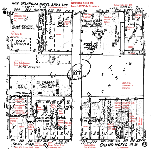
The block consisted of three-story buildings facing 2nd St. on the north and 3rd St. on the south. The upper two stories of these buildings were hotels or rooming houses: The New Oklahoma Hotel, the Oxford Hotel, the Annex Hotel, the New Miami Hotel, and the Grand Hotel. In the middle of the block on the west side was a parking lot and car rental; the mid-block lot on the east side was a Vandever's warehouse. (The 1939 Sanborn map shows two garages, capacities of 30 and 45 cars each, with steam heat, electric lights, a concrete floor, and steel truss roof.)
A note about blocks in downtown Tulsa. The Original Townsite was laid out as 300' by 300' blocks, with 80' wide right-of-way in between. (The right-of-way includes both sidewalks and streets.) Each block was bisected north to south by a 20' wide alley, and the halves thus created were split into three lots numbered, for a total of six lots, 100' wide along the avenues by 140' deep, numbered 1 through 6, clockwise from the northeast corner.
Those alleys were sacrosanct. As far as I can tell, only the train station, Central High School, and Holy Family Cathedral were allowed to build over the alleys until the urban renewal approach to redevelopment began to emerge in the '60s. The existence of the alleys limited buildings to a 42,000 sq. ft. footprint.
While the intention behind the Original Townsite plat seems to have been for frontage along the avenues, parallel to Main, many blocks, particularly closer to the railroad tracks, developed with frontage along the streets, parallel to the railroad.
That's the case for Block 107. The two mid-block lots were used for parking and a warehouse. The lots at the corners were divvied up into buildings mainly aligned to what should have been the side of the lot. Lot 3 (SE corner) was filled by two separate three-story buildings, each with rooms on the upper stories, and each subdivided on the 1st level into narrow storefronts. 42' appears to be the typical width.
Here are some photos from the Beryl Ford Collection showing this block. This photo, taken August 29, 1961, is looking south (up hill) on Cincinnati from just north of 2nd Street. (Accession B8855.) (Click to see the full size.)

(Photos from the Beryl Ford Collection/Rotary Club of Tulsa, Tulsa City-County Library and Tulsa Historical Society.)
There's the Oklahoma Tire and Supply Store No. 1 in the foreground left, on the northwest corner of Block 107, southeast corner of 2nd and Cincinnati, with the Bell Hotel on the upper two stories. (Sanborn map calls this the New Oklahoma Hotel; there's no entry in the 1957 Polk Directory for a hotel at that address.) Further south is a sign for the Rent-A-Car agency, and behind that is the three-story building on the northeast corner of 3rd & Cincinnati that housed the New Miami Hotel, the Annex Hotel, Beneficial Finance, Filter Queen Vacuums sales and service, Acme Electric, Tulsa Elevator, several answering services, and a couple of print shops.
Further down Cincinnati on the left you can see two buildings that are still standing: the KC Auto Hotel and steeple of First Baptist Church. On the right (west) is the Hotel Tulsa, now the site of the Performing Arts Center.
Here's a much earlier photo of the Oklahoma Tire & Supply Co.

If you want to get a sense of the height and scale of the three-story hotel/retail buildings that lined the north nd south edges of this block, look at the Pierce Building on the NE corner of 3rd and Detroit. Now home to TV station CW 19, this building also had a hotel on the upper two stories. Imagine similar buildings lining 3rd and 2nd, the same kinds of buildings that house El Guapo and McNellie's. Imagine what might have been if those three-story buildings hadn't been razed for parking.
One fact I'd like to know, but don't: The population for this block in 1950 or 1960.
(UPDATE 2008/06/10: This was the most populous block in downtown Tulsa in 1960 -- population 199.)
If you have stories about Block 107, please post them in the comments or e-mail me at blog at batesline dot com.
MORE: Found a few more photos that show other parts of Block 107, after the jump. And commenter Mark compares the 1957 listings to his 1947 Polk directory and finds that much had changed in the course of a decade.
UPDATE 2025/02/18: The Tulsa World reported on June 29, 1973, that the contract had been awarded for demolition of the Hotel Tulsa and "a block long apartment hotel complex on the north side of 3rd Street between Cincinnati and Detroit." An accompanying photo shows the Hotel Tulsa and the Annex Hotel, north side of 3rd between Cincinnati and the alley. The OTASCO building can be seen behind the Annex Hotel. The block between 1st and 2nd, Boston and Cincinnati, had already been demolished. The story also reports that a contract had been awarded for clearing "112 structures in the Neighborhood Development Program area" between Cincinnati and the Midland Valley Railroad, Pine and Archer -- basically the Greenwood District -- including the Rex Theater at 1135 N. Greenwood, which closed in 1967.
The Library of Congress now has a color image online of the 1962 Sanborn map for downtown Tulsa between 2nd & 5th, Boston & Detroit.


0 TrackBacks
Listed below are links to blogs that reference this entry: If asphalt could talk: Block 107, 2nd to 3rd, Cincinnati to Detroit.
TrackBack URL for this entry: https://www.batesline.com/cgi-bin/mt/mt-tb.cgi/4017
That's cool Michael. I have a 1947 Polk Directory, so I was curious to see how much things changed in a single decade. The answer is . . . much more than I would have guessed.
Here's a list of the 1947 listings that are DIFFERENT than 1957:
2nd Street:
206 -- New Oklahoma Hotel (New Oklahoma Cigar Stand in lobby)
212 -- Walker's Café
218 -- Vacant
222 -- Second Street Barber Shop
224 -- Second Street Bar
224-1/2 -- Athens Hotel
3rd Street:
201 - American Bus Line
203 -- Liberty Café
211 -- Oklahoma Barber & Beauty Supply Co.
213 -- American LaFrance Foamite Corp (fire extinguishers)/Fair Brokerage Co. (food brokers)/Studer Printing Co.
215 -- Olds Press
217-223 -- Bottenfield's Beauty Supplies
225 -- [No "Exchanges" listed]
227-229 -- Oertle Drugs
231 -- McDonald Printing & Lithographic Co.
Cincinnati:
211-213 -- Acme Cab Co./Acme Cab Recapping Co./Acme Rent-A-Car Co.
215 -- Aluminum Awning Co.
219 -- Brix Printing Co.
Detroit:
206 -- Veterans Electric Co.
208 -- George H. Trilck (signs)
Thanks very much, Mark! I hope you'll add info from 1947 to future installments in the series. I suspect there was a lot of change in those 10 years, certainly much more than the preceding decade.
I see a couple of familiar names in the 1947 listing: Oertle, who later had a department store at 25th & Memorial, and Brix, which I believe is still around, at 608 E. 3rd St.
As I've begun to research the next blocks in the series, I've noticed that by 1962, many buildings that are present in the 1939 Sanborn maps have already been replaced by parking lots, and the 1957 Polk listings suggest that the buildings were gone by then.
Its interesting to read your comments on the alleys and how important they were deemed to be. It reminds me of something else someone said recently that made sense. "Not all streets can be great streets. If you try to make every street a great street... none of them will be." It makes sense that your going to need alleys, side streets or the occasional "bad street" so that you can concentrate, rather than disperse, your pedestrian friendly assets.