Tulsa Downtown: May 2008 Archives
I was in studio this morning with KFAQ's Pat Campbell to discuss the latest developments in the proposal to build a new ballpark for the Tulsa Drillers in downtown Tulsa, prompted by the announcement that the Drillers and the City of Tulsa are extending negotiations for 45 days. (Here's a link to the MP3 podcast.)
Here's a timeline of Tulsa baseball since the move from McNulty Park (where the downtown Home Depot is now) to the Fairgrounds.
1932: First Oilers season at the Fairgrounds.
1977: Before first Drillers season, part of grandstand at old Oiler Park collapses.
1979: County bond issue to build new park fails.
1981: Sutton Stadium opens to the east of the existing ballpark, later renamed Tulsa County Stadium.
1989: Renamed Driller Stadium.
1991: Tulsa one of five finalists for AAA expansion, passed over for Ottawa, Charlotte, and New Orleans.
1992: Camden Yards opens, heralding the neo-traditional era of ballpark construction.
1993: Oklahoma City approves MAPS, which includes a ballpark for Bricktown.
1993: Prescription Athletic Turf installed.
Mid-1990s: Discussed for possible inclusion in Tulsa Project; soccer stadium proposed instead. TP defeated in October 1997.
1998: Bricktown Ballpark opens in Oklahoma City.
1998: Tulsa not selected in AAA expansion; Memphis and Durham chosen.
2000: "It's Tulsa's Time" package for arena and convention center doesn't include ballpark.
2003: Ballpark included in feasibility study for downtown facilities, but ultimately left out of Vision 2025. Drillers uninterested in moving.
March 2006: Went Hubbard turns over majority ownership to Chuck Lamson.
August 2007: Drillers sign non-binding letter of intent with Jenks River District.
January 2008: Lamson says he wants to be in a new park by 2010.
January 23, 2008: Drillers enter into four-month negotiating period with City of Tulsa.
May 23, 2008: Drillers and City extend negotiations by 45 days.
Possible sites include the old Nordam site (4th to 6th, Frankfort to Lansing), the Hartford Building site (north of 2nd between Greenwood and Hartford); northeast of Archer and Elgin; and the Evans Electric site between OSU-Tulsa and US 75, although there are rumors that the site currently under discussion is none of the above.
Here's my UTW column about the Drillers' options for moving, along with some of their history from last August when the City of Tulsa began wooing the Drillers in earnest. And here's a more recent column, from February, about Jenks' demographic advantages over downtown Tulsa for providing a fan base for the Drillers. Also, in a February UTW op-ed County Commissioner Randi Miller discussed what might be done with the current stadium when the Drillers move.
My column in the current issue of Urban Tulsa Weekly was about what I learned during a visit to last weekend's Blue Dome Arts Festival. As I made my way around 1st & Elgin, I had a peek at plans for Joe Momma's Pizza's downtown location, a guided tour of the under-construction 1st Street Lofts, a chat with Diversafest's Tom Green about the festival's non-profit arm, the Oklahoma Foundation for the Music Industry, and heard from Cain's Ballroom owners Jim and Alice Rodgers about their new venture on Brookside, Ida Red. It was exciting to hear about all these plans to make Tulsa a more exciting place to live, work, and play.
Something I neglected to point out in the column: Everyone of these cool new ventures is happening in old buildings. I devoted a column in April to the importance of old buildings to a lively city, and I quoted Jane Jacobs on the matter:
Chain stores, chain restaurants and banks go into new construction. But neighborhood bars, foreign restaurants and pawn shops go into older buildings. Supermarkets and shoe stores often go into new buildings; good bookstores and antique dealers seldom do....As for really new ideas of any kind -- no matter how ultimately profitable or otherwise successful some of them might prove to be -- there is no leeway for such chancy trial, error and experimentation in the high-overhead economy of new construction. Old ideas can sometimes use new buildings. New ideas must use old buildings.
This is the first installment in what may be a regular series.
Have you ever looked at a parking lot downtown and wondered what used to be there? I'm going to try to use old fire insurance maps and street directories to piece together the past lives of parking lots and other parcels drastically transformed since downtown's mid-20th century heyday.
Up first is Block 107 of Tulsa's Original Townsite, between 2nd and 3rd Streets, Cincinnati and Detroit Avenues. Today this block is one 90,000 sq. ft. surface parking lot just east of the Performing Arts Center. The block slopes downhill from 3rd to 2nd. I estimate the drop at about 15 feet.
The map below uses the 1962 Sanborn fire insurance map as a base, with my notations in red indicating businesses that were listed in the 1957 Polk City Directory for Tulsa. (I used 1957, because that's what I had available, from my 1957 researches last year.) Click on the thumbnail to pop-up the full 1800 by 1800 image.
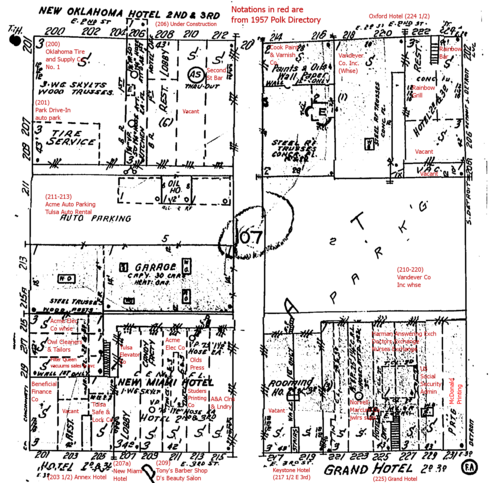
The block consisted of three-story buildings facing 2nd St. on the north and 3rd St. on the south. The upper two stories of these buildings were hotels or rooming houses: The New Oklahoma Hotel, the Oxford Hotel, the Annex Hotel, the New Miami Hotel, and the Grand Hotel. In the middle of the block on the west side was a parking lot and car rental; the mid-block lot on the east side was a Vandever's warehouse. (The 1939 Sanborn map shows two garages, capacities of 30 and 45 cars each, with steam heat, electric lights, a concrete floor, and steel truss roof.)
A note about blocks in downtown Tulsa. The Original Townsite was laid out as 300' by 300' blocks, with 80' wide right-of-way in between. (The right-of-way includes both sidewalks and streets.) Each block was bisected north to south by a 20' wide alley, and the halves thus created were split into three lots numbered, for a total of six lots, 100' wide along the avenues by 140' deep, numbered 1 through 6, clockwise from the northeast corner.
Those alleys were sacrosanct. As far as I can tell, only the train station, Central High School, and Holy Family Cathedral were allowed to build over the alleys until the urban renewal approach to redevelopment began to emerge in the '60s. The existence of the alleys limited buildings to a 42,000 sq. ft. footprint.
While the intention behind the Original Townsite plat seems to have been for frontage along the avenues, parallel to Main, many blocks, particularly closer to the railroad tracks, developed with frontage along the streets, parallel to the railroad.
That's the case for Block 107. The two mid-block lots were used for parking and a warehouse. The lots at the corners were divvied up into buildings mainly aligned to what should have been the side of the lot. Lot 3 (SE corner) was filled by two separate three-story buildings, each with rooms on the upper stories, and each subdivided on the 1st level into narrow storefronts. 42' appears to be the typical width.
Here are some photos from the Beryl Ford Collection showing this block. This photo, taken August 29, 1961, is looking south (up hill) on Cincinnati from just north of 2nd Street. (Click to see the full size.)

(Photos from the Beryl Ford Collection/Rotary Club of Tulsa, Tulsa City-County Library and Tulsa Historical Society.)
There's the Oklahoma Tire and Supply Store No. 1 in the foreground left, on the northwest corner of Block 107, southeast corner of 2nd and Cincinnati, with the Bell Hotel on the upper two stories. (Sanborn map calls this the New Oklahoma Hotel; there's no entry in the 1957 Polk Directory for a hotel at that address.) Further south is a sign for the Rent-A-Car agency, and behind that is the three-story building on the northeast corner of 3rd & Cincinnati that housed the New Miami Hotel, the Annex Hotel, Beneficial Finance, Filter Queen Vacuums sales and service, Acme Electric, Tulsa Elevator, several answering services, and a couple of print shops.
Further down Cincinnati on the left you can see two buildings that are still standing: the KC Auto Hotel and steeple of First Baptist Church. On the right (west) is the Hotel Tulsa, now the site of the Performing Arts Center.
Here's a much earlier photo of the Oklahoma Tire & Supply Co.

If you want to get a sense of the height and scale of the three-story hotel/retail buildings that lined the north nd south edges of this block, look at the Pierce Building on the NE corner of 3rd and Detroit. Now home to TV station CW 19, this building also had a hotel on the upper two stories. Imagine similar buildings lining 3rd and 2nd, the same kinds of buildings that house El Guapo and McNellie's. Imagine what might have been if those three-story buildings hadn't been razed for parking.
One fact I'd like to know, but don't: The population for this block in 1950 or 1960.
(UPDATE 2008/06/10: This was the most populous block in downtown Tulsa in 1960 -- population 199.)
If you have stories about Block 107, please post them in the comments or e-mail me at blog at batesline dot com.
MORE: Found a few more photos that show other parts of Block 107, after the jump. And commenter Mark compares the 1957 listings to his 1947 Polk directory and finds that much had changed in the course of a decade.