Segregation by Design: Greenwood and I-244
Tulsa is the focus of another recent article from a UK newspaper website: A story in the Guardian Online about the impact of expressway construction on Tulsa's Greenwood neighborhood, and the possibility of reviving the neighborhood by removing the north leg of the Inner Dispersal Loop.
Twenty-five years before Don Shaw was born in Greenwood, a white mob invaded the Tulsa neighborhood and killed more than 300 people. Much of the tight-knit community was burned to the ground, including his grandfather's pharmacy.But when Shaw was growing up in the 1950s and 60s, few people wanted to talk about the massacre - perhaps in part because much of the damage was no longer visible.
He remembers walking the streets of Greenwood in his youth and seeing Black-owned businesses up and down its blocks: a hotel, dry cleaner, soul food restaurants, churches, a ballroom, dentists, pharmacies, hardware store, photo studio, the 750-seat Dreamland Theatre. It was an oasis of Black economic self-sufficiency, inside an Oklahoma city flush with oil industry wealth where the Klu [sic] Klux Klan once publicly operated.
"There was a lot of parties," recalled 76-year-old Shaw, who has lived in Greenwood his whole life. "Dances and stuff like that, concerts, lots of stuff going on."...
By December 1921, more than half of the homes that were destroyed had been rebuilt, despite city leaders rewriting zoning and fire codes to prevent the Black neighborhood from surviving. (Some Greenwood locals worked on their homes at night to avoid policemen.) When I-244 came decades later, resistance to the highway was undermined by a lack of Black representation in city government.
The Guardian story was apparently inspired in part by a graphic depiction of the effects of I-244 on the neighborhoods north, northeast, and northwest of downtown Tulsa, produced by New York City architect Adam Paul Susaneck for his @Segregation_by_Design Twitter account. Susaneck got in touch with me back in early June, looking for aerial photos and other information that would help him with a then-and-now visualization of the sort that he has done for many other cities, part of a long-term project (segregationbydesign.com) to depict vividly the destruction wrought by Federal highway and urban renewal funding.
Using historic aerial photography, this ongoing project aims to document the destruction of communities of color due to red-lining, "urban renewal," and freeway construction. Through a series of stark aerial before-and-after comparisons, figure-ground diagrams, and demographic data, this project will reveal the extent to which the American city was methodically hollowed out based on race. The project will cover the roughly 180 municipalities which received federal funding from the 1956 Federal Highway Act, which created the interstate highway system.Since the creation of the Interstate, freeway planning has been an integral tool in the systematic, government-led segregation of American cities. Used not only as a direct means to destroy the communities in their paths, freeways have also been used to cement racial segregation and ensure its endurance. Working synergistically with the legacy of redlining, freeway planning became the ultimate enforcement mechanism: literal walls of concrete and smog that separated black communities from white. In the name of the thinly veiled racist policies of "urban renewal," the freeways took the red lines off the map and built them in the physical world.
Here is the minute-and-a-half video on Tulsa, Greenwood, and I-244:
Greenwood, Tulsa--the famous "Black Wall Street"--before and after highway construction and "urban renewal."
— Segregation_by_Design (@SegByDesign) July 19, 2023
"Decades after the Tulsa Race Massacre [in 1921], urban 'renewal' [in the 1960s] sparked Black Wall Street's second destruction," writes @SmithsonianMag. pic.twitter.com/Qz099Ww1nt
After a street scene from circa 1949, looking north on Greenwood from just north of Vernon AME Church, the video shows the same location today, with homes and shops replaced by today's empty OSU-Tulsa parking lots. The view shifts to a 1951 aerial, zooming in to Admiral Blvd and 1st Street, just west of Utica Ave. The view pans west, as a modern aerial photo replaces the 1951 aerial, showing not only the destruction in the immediate path of the expressway, but the erosion of neighborhoods bordering the expressway, with homes and churches and schools replaced by parking lots and industrial buildings.
At about 27 seconds in, we see an outline showing the boundary of the Greenwood District, and we see I-244 take out two-thirds of what had been a densely-developed business block between Greenwood, Hartford, Archer, and Cameron, and then another business block between Brady, Cameron, Greenwood, and Frankfort. Continuing west, the highway took out more homes and businesses in Greenwood and in the adjacent neighborhood west of Detroit Ave that I've called the Near Northside. A wider swath was cut to build the Cincinnati-Detroit interchange with I-244, and Cincinnati, which had stopped north of Standpipe Hill, now cut through it.
At 41 seconds, I-244 crosses Main Street, sparing Cain's Ballroom. A few seconds later, the massive northwest IDL interchange, connecting the Tisdale Expressway, the Keystone Expressway, and the west leg of the IDL (I-244) wipes out a working-class white neighborhood and cuts downtown off from Owen Park and Crosbie Heights. Edison Junior High gets cleared for the Keystone Expressway at 54 seconds, and then more destruction along the southern edge of the Owen Park neighborhood. When the expressway reaches Yukon Ave, the view zooms out to show a modern aerial view, with the expressways that ring downtown highlighted in yellow, and then the same view from 1951.
The devastation caused by the expressway was significant, particularly to the area known as Deep Greenwood, the commercial district centered on Archer and Greenwood. A May 4, 1967, Tulsa Tribune story, republished here on BatesLine, An Old Tulsa Street Is Slowly Dying, had a photo of the demolition of the Dreamland Theater (at the time, an Elks Lodge) and comments from merchants who were being displaced by the expressway.
The Guardian article discusses the $1.6 million FY22 Reconnecting Communities grant received by the North Peoria Church of Christ, for "I-244 Partial Removal Study." They hope to place the reclaimed land in a trust, to reconnect the street grid, and to avoid gentrification.
But the Grauniad story and the I-244 removal effort misses an important factor in the second demise of Greenwood. The damage done by the expressway was compounded by the "Model Cities" program, the new, Federally funded and allegedly humane approach to urban renewal. It, too, was adopted in 1967, the same year that the path of the expressway was cleared through the neighborhood. The aerial photo from September 10, 1967, suggests that had the expressway been the only insult suffered by the Greenwood District, it might have survived, but Model Cities cleared out everything except the churches and the little remnant of the commercial district south of I-244. Even the original Booker T. Washington High School building, which had survived the 1921 massacre (the L-shaped complex in the upper left of the photo below) was demolished in 1983 in the name of "renewal."
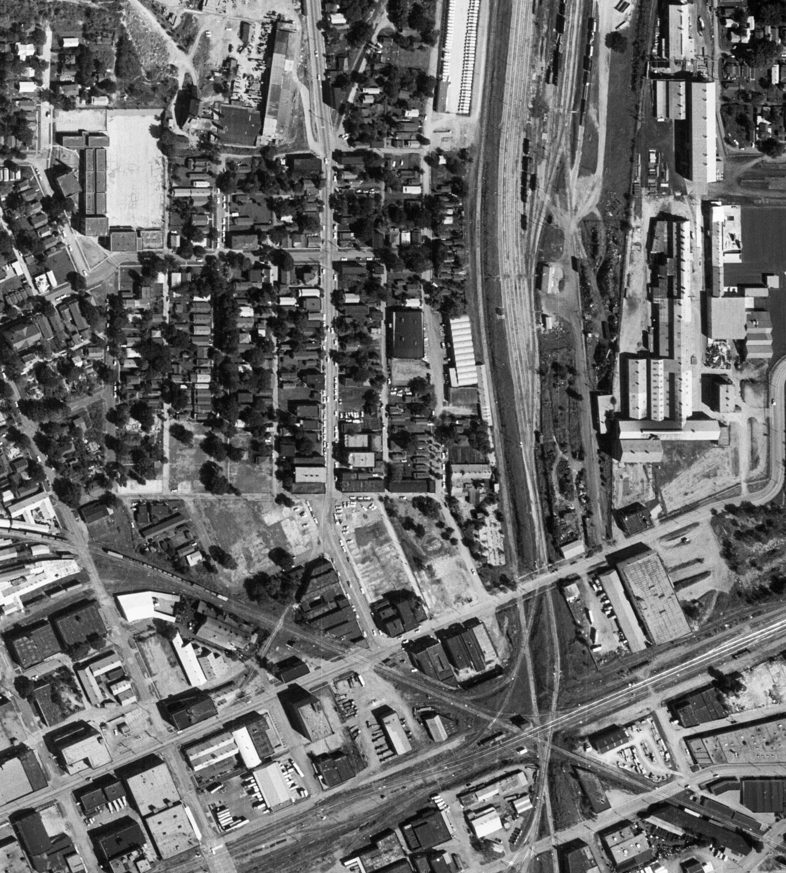
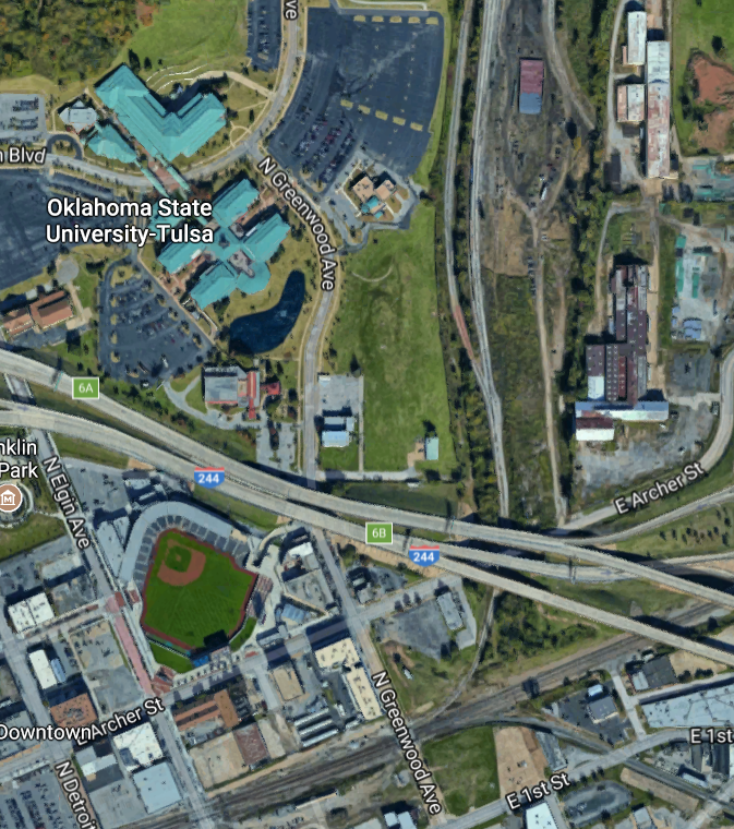
Here is the same area as captured in 2017 from Google Maps.
In 2007, after my Urban Tulsa column on the Greenwood Gap Theory (the belief that Greenwood was never rebuilt after 1921), OSU-Tulsa professor J. S. Maloy challenged the idea that government was the problem, not the solution, for Greenwood's revival. My response described the full extent of what had been lost and what had replaced it:
Finally, Prof. Maloy wants to know why the "Do-It-Yourself approach" which worked to rebuild Greenwood after the 1921 riot hasn't worked in the 40 years since urban renewal and the construction of I-244.It's simple: After 1921, the land remained in private ownership, and the victims of the riot could rebuild what had been burned down.
But in the '60s and '70s, urban renewal took the land out of private ownership. Most of the south end of the district is still owned by some government entity. The urban renewal authority has sold some of the land in the northern part back to private owners, but mainly for residential and industrial development. There is no land available for new commercial development.
For example, if you wanted to rebuild the Holloway Building at 350 N. Greenwood Av. (home, in 1957, to Holloway's Hardware and Appliances, Holloway Dental Laboratory, a doctor's office, and an advertising and painting company), you'd have to fill in a pond, and you'd have to get permission from Prof. Maloy's employer. OSU-Tulsa controls all of Deep Greenwood north of I-244, with the exception of two churches and the City's Greenwood Cultural Center.
The commercial buildings between King and Pine Streets (including the Rex Theater) which faced Greenwood were cleared by urban renewal and replaced with suburban homes facing the side streets, many of which have been turned into cul-de-sacs. Only a few churches, Carver Middle School, the old Public Library (now a Unitarian Church), and a few homes remain from the pre-urban renewal days.
City officials created an industrial park out of the area between the Midland Valley and Santa Fe tracks and south of Pine, which once had been residential and commercial. (It had its own movie theater, the Regal, on Lansing Ave.) Morning Star Baptist Church and Hutcherson YMCA are about the only buildings in that area that survived urban renewal.
There is one part of Deep Greenwood which might yet be redeveloped, south of I-244 and northeast of Archer and Elgin. It is owned by the Tulsa Development Authority (the renamed urban renewal authority). There have been proposals for mixed-use development on that site, but the TDA has yet to approve any of them, to the consternation of many north Tulsa community leaders.
Since I wrote that, the parcel I mentioned has been redeveloped as Oneok Field, home of minor-league Tulsa Drillers baseball.
The bottom line is this: If you want to recreate the Greenwood District, you not only need to remove part of I-244, but while you're at it, you had better demolish OSU-Tulsa, with its suburban mall architecture and parking layout. If you want to regenerate the whole of the African-American neighborhood that was destroyed by the City of Tulsa with help from federal highway and urban renewal money, you'll also need to clear out the Lansing Industrial Park and rebuild the neighborhood and commercial district that was once there. The cul-de-sacs and 1980s homes on the upper end of Greenwood near Pine will have to go, too; a neighborhood commercial district of street-fronting storefronts, including a movie theater, was demolished because urban "experts" of the '60s and '70s believed that retail had a blighting effect on residential neighborhoods.
From an earlier BatesLine post on Greenwood and urban renewal:
In April 1970, as Tulsa's Model Cities urban renewal program was beginning to demolish homes, Mabel Little, whose new home was burned down in the 1921 attack, told the Tulsa City Commission [from the April 11, 1970, Tulsa Tribune]:
"You destroyed everything we had. I was here in it, and the people are suffering more now than they did then."
Years later, Jobie Holderness reflected on the spiritual damage done by urban renewal:
"Urban renewal not only took away our property, but something else more important -- our black unity, our pride, our sense of achievement and history. We need to regain that. Our youth missed that and that is why they are lost today, that is why they are in 'limbo' now."
Removing an expressway, over a half-century after it was built, won't be enough to reverse that damage.
MORE: All of BatesLine's articles on Greenwood are indexed here:
0 TrackBacks
Listed below are links to blogs that reference this entry: Segregation by Design: Greenwood and I-244.
TrackBack URL for this entry: https://www.batesline.com/cgi-bin/mt/mt-tb.cgi/9081