Travel Category
Before Eisenhower's Interstate Highway System, before state highway officials collaborated to create a national highway numbering system in 1926, motorists traveling cross-country followed turn-by-turn directions contained in the Official Automobile Blue Book. These books are a time capsule of transportation history, not only mentioning routes, but road conditions, locations of hotels, garages, train stations, and trolley tracks.
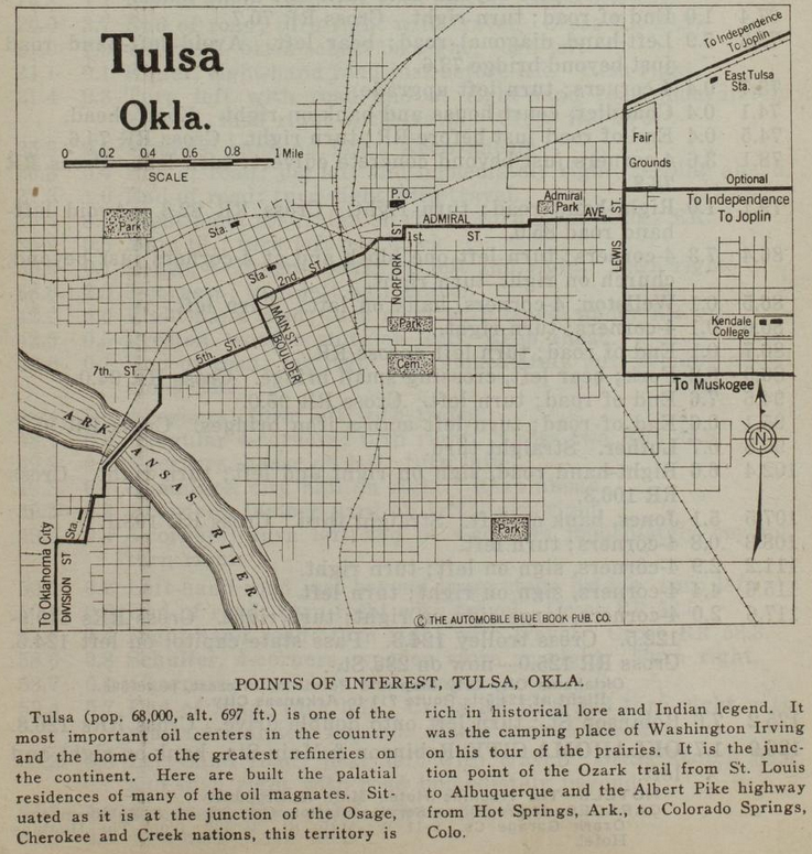
Above is a map of Tulsa from the Official Automobile Blue Book, 1920 edition, Volume 7, p. 779. That link will lead you to the page that begins the Route 901, 126.9 miles from 2nd & Main in Tulsa to Robinson & Main in Oklahoma City.
Only the streets that matter for inter-city motoring are labeled. The reset have to be inferred from old maps.
Heading east, the route goes down 2nd, but bends left at Kenosha onto 1st Place, and then joins 1st Street at Lansing Ave. Two blocks east at Norfolk (misspelled as Norfork) it jogs north to Admiral Blvd, which is today the north service road for I-244. Admiral Blvd jogs north at Utica, and the route reaches Whittier Square at Lewis, where it forks three ways.
- To Independence and Joplin: North on Lewis, east on Dawson Road.
- Optional to Independence and Joplin: North on Lewis, east on Archer Street
- To Muskogee: South on Lewis, east on 11th Street.
The route to Oklahoma City turns south at 2nd and Boulder, west at 5th Street, which merges into 7th west of Houston Avenue. The route turns south onto Maybelle Ave to 11th Street, then diagonally southwest across the Arkansas River bridge -- this part of the route was obliterated for the SW Inner Dispersal Loop interchange. On the west side of the river, the map shows the route heading south on Quanah to 17th, west to a road that follows the east side of the Frisco tracks to 19th, then west on 19th to Union Ave (labeled Division Street on this map). It looks to me like the mapmaker misidentified Union as Division; the 1920 census enumeration district map shows present-day Quanah Ave was West Tulsa's Division Street, before the annexed town's street names were normalized with Tulsa's, so in all likelihood, the route followed Quanah south, then Southwest Boulevard, then Old Sapulpa Road through Oakhurst and Bowden, into Sapulpa on Mission Street and Dewey Ave, then following the old Ozark Trail / Route 66 alignment that parallels and passes under the Frisco tracks.
The trolleys mentioned in the turn-by-turn route instructions are the Tulsa Street Railway (specifically the 5th Street track and the car barns at 5th/7th & Lawton) and the Sapulpa & Interurban, aka Oklahoma Union Traction, with an interurban line crossing the Arkansas River at West Tulsa and city streetcar lines in Sapulpa.
The Tulsa map shows SL&SF (Frisco -- SW to NE), AT&SF (Santa Fe -- SW to N), MKT (Katy - W to SE), and Midland Valley (N to S) railroads, but we can only infer electric interurban lines from mentions in the turn-by-turn text. These railroad stations are shown but Midland Valley is absent:
- MKT at Main between Cameron & Easton.
- SL&SF/ATS&F at Boston south of the Frisco tracks (to be replaced by Union Station)
- West Tulsa station south of what would be 18th & Santa Fe, west of the tracks
- East Tulsa Frisco station at about Delaware Ave, south of the Frisco tracks
Civic amenities shown include Oaklawn Cemetery, Owen Park, Central (Centennial) Park, and Swan Lake Park, but only Admiral Park is named. Kendall College (now University of Tulsa) is misspelled as Kendale, but shown as a couple of buildings east of College Ave between 5th and 7th. The Fair Grounds were between Archer St and the Frisco tracks, from Lewis to about Archer Place. The near northside is hidden beneath the title and scale on the upper left, but deep Greenwood Ave is not hidden. A Post Office is shown on the east side of Madison just north of the Frisco tracks, which seems strange, as that location is isolated from the center of town.
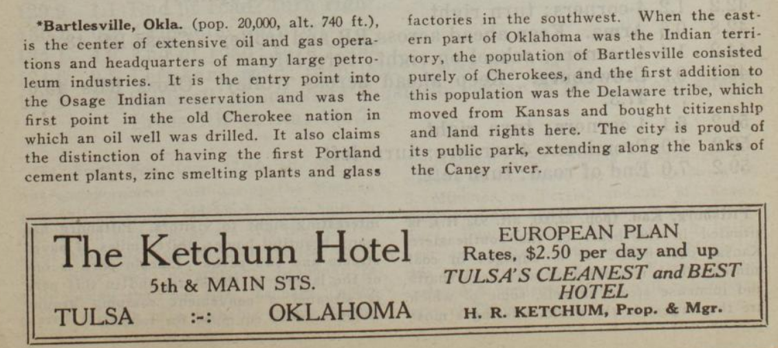
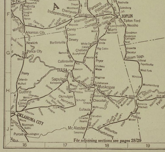
Route 902 is a longer route to Oklahoma City, 168.4 miles via Okmulgee and Henryetta, but it avoids Creek County oilfield traffic. Route 905 takes the Ozark Trail from Tulsa to Joplin, but you go through Owasso, where there was an Ozark Trail monument, to get to Claremore. Route 906 links Tulsa with Bartlesville and Independence, Kansas, paralleling present day US 75. Route 910 goes from Tulsa through Bixby to Muskogee. Each route has its reverse: Route 931 heads back from Independence to Tulsa, concluding with a description of Bartlesville and an ad for the Ketchum Hotel at 5th & Main in Tulsa.
MORE:
Hathi Trust partial collection of Automobile Blue Book volumes
1919 Official Automobile Blue Book, Volume 7, Tulsa map. In this edition, there is no route description for Tulsa to OKC via Stroud, but the road is depicted on the overview map.
"The Official Automobile Blue Book, 1901-1929: Precursor to the American Road Map," John T. Bauer (Department of Sociology, Geography, and Earth Science, University of Nebraska at Kearney), Cartographic Perspectives (Number 62, Winter 2009): Includes a list of all known editions with a breakdown by volume -- very helpful for finding the volume of interest in the Internet Archive and other online libraries.
RELATED:
Automobile Club of Southern California's beautiful strip maps of the National Old Trails Road from Los Angeles to Kansas City, with branches to Denver, Cheyenne, Big Springs, Nebraska, and the Grand Canyon. The stretch from Las Vegas, NM, to Los Angeles was the starting point for US 66 in 1926.
The National Old Trails Road: The great historic highway of America, a brief resume of the principal events connected with the rebuilding of the old Cumberland--now the National old trails road--from Washington and Baltimore to Los Angeles: A 1926 book with lots of interesting history about the evolution of named and numbered highway systems, beginning with the National Road from Cumberland, Maryland, to Vandalia, Illinois. Includes an unsuccessful 1913 congressional proposal detailing 18 numbered highways that would be improved with money from a new federal tobacco tax. Roads 11 and 13 would pass through Muskogee and Oklahoma City, but Tulsa doesn't get a mention. Also much discussion about the proper and constitutional role of the federal government in road building.
Mike McUsic, a historical researcher on the topic of the Green Book, the segregation-era travel guide for African-American tourists, will be leading walking tours of the Green Book locations in Tulsa's Greenwood District on June 8th at 10:00 am and 3:00 pm, and on June 15th at 10:00 am. Tickets are $15, available via Eventbrite.
Mr. McUsic has developed the Green Book Travelers HistoryPin site, locating 1,900 Green Book locations across the country, with names, descriptions, and historic and present-day photos. This link will take you to locations specific to Greenwood.
Mr. McUsic provided a helpful correction to my piece about the fate of Tulsa's Green Book businesses with information about the address of Mince's Service Station -- Red's Bar at 325 E. 2nd Street, these days -- one of the handful of Green Book sites still standing.
MORE: Here's a collection of links to BatesLine articles and other resources about Greenwood and Black Wall Street.
Your membership in your local art or historical museum is worth more than free local admission thanks to the North American Reciprocal Museum Association. It acts as a season pass, providing member access to museums in all 50 states, Washington, DC, as well as several sites in Canada, Mexico, El Salvador, and Bermuda. While some member institutions restrict benefits for members of nearby institutions, that's not the case for any of the Oklahoma members of NARMA in the Spring 2019 list.
- Bartlesville, Price Tower Arts Center
- Bartlesville, Woolaroc Museum & Wildlife Preserve
- Broken Arrow, The Museum Broken Arrow
- Claremore, Will Rogers Memorial Museums
- Duncan, Chisholm Trail Heritage Center
- Grove, Har-Ber Village Museum
- Idabel, The Museum of the Red River
- Muskogee, Muskogee War Memorial Park: Home of the USS Batfish
- Norman, Fred Jones Jr. Museum of Art
- Oklahoma City, National Cowboy & Western Heritage Museum
- Oklahoma City, Oklahoma City Museum of Art
- Oklahoma City, Oklahoma Contemporary Arts Center
- Ponca City, Ponca City Art Center
- Shawnee, Mabee-Gerrer Museum of Art
- Stillwater, Oklahoma State University Museum of Art
- Tulsa, Gilcrease Museum
- Tulsa, Philbrook Museum of Art
- Tulsa, Tulsa Air and Space Museum & Planetarium
Looking through the list, I see dozens of places I've visited (and paid separate admissions for) in my travels, places like the Institute of Texan Cultures and the San Antonio Museum of Art in San Antonio, the Tennessee State Museum in Nashville, the Bailey-Mathews National Shell Museum on Sanibel Island, HistoryMiami, the Wolfsonian in Miami Beach, the Charles M. Schulz Museum in Santa Rosa, California, the Legion of Honor in San Francisco, the Dali Museum in St. Petersburg, the Hawaiian Mission Houses in Honolulu, and the Princeton University Art Museum. There are plenty of other sites that I've passed by where I might have happily spent an hour getting just a taste of the exhibits if I knew I could go in without paying full admission.
During my time in the UK last year, I bought memberships in the National Trust (mainly stately homes), English Heritage (castles, ruins, battlefields), and Historic Royal Palaces (includes Tower of London, Hampton Court Palace, and Kensington Palace), knowing that I'd be there long enough and visiting enough sites to make the cost worthwhile. Because of the membership, I could pay a short visit that fit into my daily schedule and feel I'd got my money's worth. Here in the US, the National Parks and Federal Lands annual pass is good value. If you're a Tulsa Zoo member, you qualify for 50% off admission at participating zoos in the Association of Zoos and Aquariums.
As always, consult the NARM Association website and the websites of the specific museums for details and full terms and conditions.
A friend recently asked for advice on places to visit in Australia and New Zealand. Our family had the blessing of visiting both countries a couple of years ago, and I returned briefly the following year. I had plenty of happy memories to share.
I don't write about our travels while we're traveling, mainly because we're too busy sightseeing, and when things quiet down at night, I'm occupied with planning the next day's activities. So travel writing has to happen retrospectively. I hope to do more of that this year.
When I gave my family a choice of a second place to visit for a few days, on top of our week together in Brisbane, Australia, they were unanimous in selecting New Zealand, preferring it to the tropics and Great Barrier Reef and to the "red centre" of Australia -- Uluru and Alice Springs. The kids are all fans of Tolkien and leapt at the chance to see locations used in the Lord of the Rings and Hobbit films, particularly Hobbiton Movie Set, which was built as a temporary set for the Lord of the Rings trilogy then rebuilt permanently for the Hobbit trilogy to serve as a tourist attraction. (More about Hobbiton another time.)
We flew from Brisbane to Auckland, arriving after midnight (there's a three-hour time difference), then drove the rental (a Hyundai iMax "people mover") to the Waiuku Lodge Motel, the only place we could find that could accommodate the five of us in one room. Next day we had Thanksgiving day lunch at the Kentish Hotel, a pub with a claim to having the longest continuous liquor license in New Zealand. It was a two-hour drive to get to our 4 pm tour at Hobbiton, so we had to miss the black sands of nearby Kariotahi Beach.
After our Hobbiton tour, the family scoured the gift shop, and I sat at a picnic table, overlooking emerald green sheep pastures, using the wifi to search for the night's accommodations. They bought a book with details of the filming locations for the Peter Jackson movies. I paged through it looking for scenic spots we might want to visit on our way south to Wellington. There was a clear stream and spring not far away and would only add 20 minutes driving time; we could reach it before dusk. It wasn't used in the movies, but it looked like it belonged in The Shire.
Waihou is the Maori name of the river that was christened the Thames by British explorer Captain James Cook. The Te Waihou Walkway is a three-mile hiking track along the river near the village of Putaruru, and it passes the Blue Spring, which produces over 9,000 gallons of water per minute and supplies 60% of the bottled water produced in New Zealand.
The Waihou Stream is totally spring fed. Water from the Mamaku Plateau takes anywhere from 50-100 years to reach the Blue Spring. Water flows from the spring at a rate of 42 cubic metres per minute (9,240 gallons per minute). The water temperature of the Blue Spring is a constant 11 degrees celsius [52 degrees Fahrenheit] throughout the year.The reason for the blue colour (and high visual clarity) of the Waihou River and its spring source is the high optical purity of the water. Pure water is intrinsically blue in hue because it absorbs red light leaving only blue and (some) green light to be transmitted to the observer's eye. Pure natural waters are blue to blue-green in colour because they lack light absorbing constituents and particles. Both particles and light-absorbing matter are efficiently removed during the long settlement time of spring water while in aquifers.
The easiest pedestrian access was from the car park on Leslie Road. From there it's about a half-mile walk over fairly level ground to the Blue Spring.
Can alcohol be consumed on Te Waihou?
Alcohol consumption is discouraged, but can't currently be prohibited. In order to prohibit alcohol we would need to include Te Waihou in our Public Places Bylaw as a prohibited alcohol consumption area; and then of course there is the question of how to regulate, monitor and enforce.
What arrangement does Council have with the water bottlers? Council has Water Supply Agreements with each of the bottlers, which allows each of the bottles to take a certain volume of water from Councils supply each day.What do the water bottlers pay?
They pay $1.05 per m3 as per the fees and charges.Why can't Council make the water bottlers pay more?
Council treats all industry the same that use water from Council's supply, whether the water is used for wood treatment, concrete making or making cups of coffee.Can Council stop the water bottlers from taking water from the Blue Spring?
Bottlers do not take water from the Blue Spring. Council takes water from the Blue Spring under consent Council supplies half of PutÄruru with water from this source. The bottlers are only three properties that are supplied from this source.
From Hobbiton, it's about a 30 minute drive to the Leslie Road car park for Te Waihou Walkway, which is the closest access point to the Blue Spring -- about a half-mile. There are no services there. The entire walkway along the river, from Leslie Road to Whites Road, is three miles one-way. If you're on your way from Auckland to Rotorua, or from Auckland to Wellington, visiting Blue Spring adds only about 15 minutes driving time to the trip.
On the way from Hobbiton or Auckland you'll pass through Tirau, the "Corrugated Capital of the World," and see the town's tourist information office and museum -- corrugated iron buildings shaped and painted to look like a sheep, a ram, and a sheepdog, with a corrugated iron sculpture of a shepherd in front of the church next door to the northwest. There are other clever corrugated sculptures decorating the main street, plus cafes, antique shops, galleries, a pub, a motel, and a castle containing New Zealand's largest toy, doll, and train collection.
Late last night we returned from a quick five-day, nearly 2,000-mile trip to Aspen, Colorado, by way of Amarillo, Santa Fe, Taos, Buena Vista, the Great Sand Dunes, Capulin Volcano, and Black Mesa. We packed a lot into a short trip. Some notes:
Downtown El Reno has a very nice coffeehouse, Iron Tree Coffee, a handy place to take a break after two hours of driving west from Tulsa. Good coffee, some tables that were the right height for standing (a nice break), clean restroom, Boylan sodas for the non-coffee-drinkers.
The Big Texan Steak Ranch is worth the visit. Although I've seen the billboards along the highway since I was a kid, I'd never been before. The steaks and sides are really good -- we especially liked the green beans -- as are their locally produced beers. If you don't have time for a steak, they've got a coffee bar and gelato, a gift shop, and a shooting gallery. We saw two men have a go at the free 72 oz. steak dinner. One got through most of the steak, but left the side dishes mostly untouched. The other seemed to be pacing himself well, but we left before we could find out if he'd made it.
Quartz Mountain + Great Books + cool air = St. John's College Santa Fe campus. Lovely. Daughter sat in on a math class, we had lunch at the dining hall, had a campus tour, and browsed the campus bookstore, where we found, among other things, a paperback Latin dictionary and a leather bookweight. The clerk at the campus bookstore was playing Willie Nelson's Red Headed Stranger album (I was given a copy as a teenager by my aunt, and I played it over and over), and he recommended the Tune-Up Cafe for dinner, which we enjoyed.
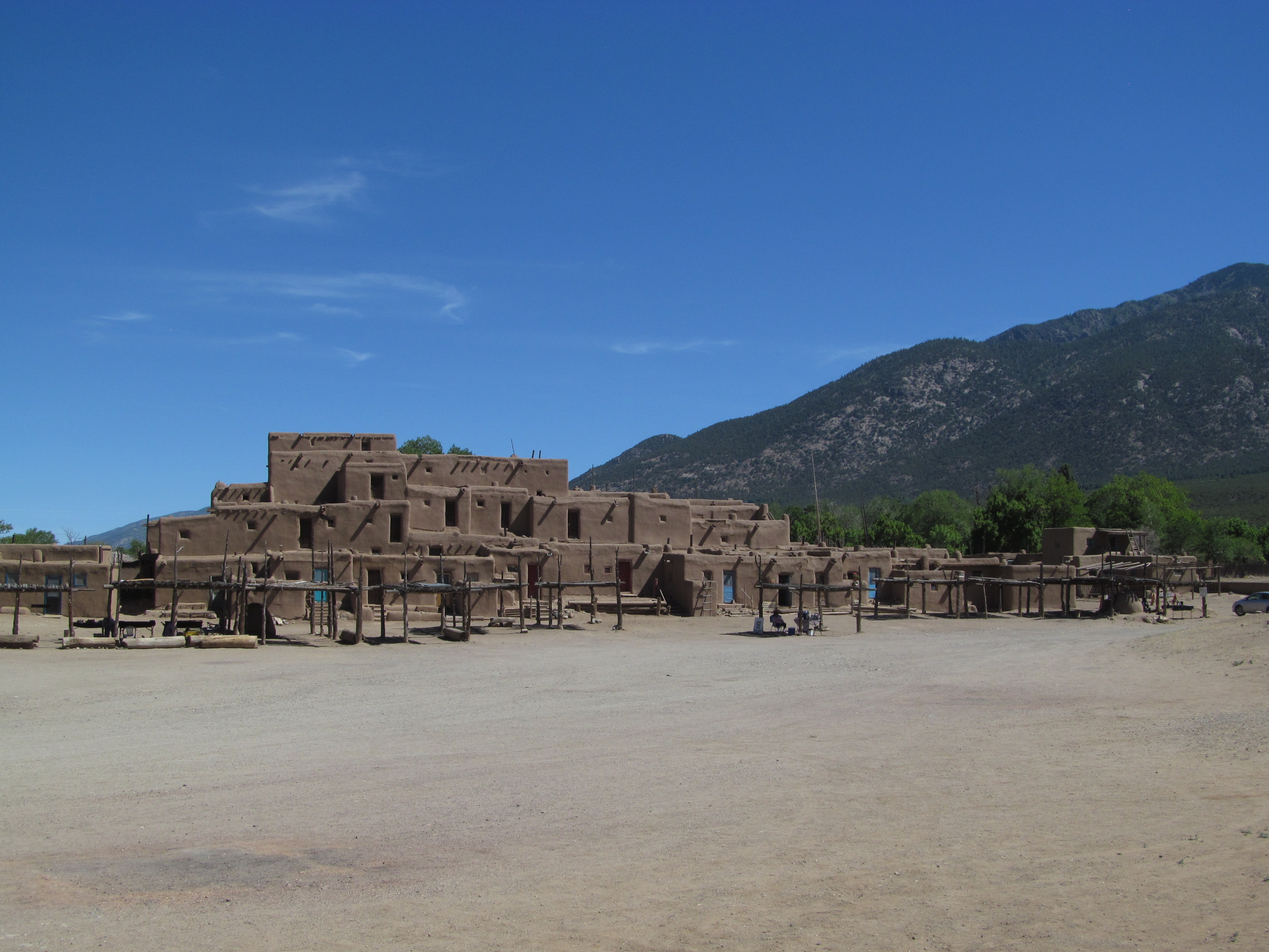
Taos Pueblo is worth the visit for the aesthetics alone -- the light brown adobe walls against the deep blue sky, and the sharp shadows shifting as the sun traveled across the sky. The tour, conducted by a college student who grew up on the pueblo was good, but we learned more from Priscilla, the 86-year-old grandma selling snow cones on the plaza.
The folks at the Taos Hampton Inn were very nice and very helpful, especially Maria who was managing the evening shift evidently all by herself, but I sort of wish we'd stayed in one of the historic hotels near the Plaza (e.g. La Fonda, Taos Inn).
On the north side of Taos Plaza there is a very good outdoor store (Taos Mountain Outfitters), an old-fashioned five-and-dime with a lunch counter (Taos Trading Co.), a coffeehouse plastered with far-left bumperstickers (World Cup), among other establishments. A second-floor courtroom in the back of the old courthouse, built in 1932, has some impressive WPA-commissioned murals on the theme of justice. The centerpiece, which would have been behind the judge's bench, was of Moses the Lawgiver. (The Spanish title, Moses El Legisladór, seems to reduce the leader of the Israelites to ranking member on an obscure subcommittee.) My favorite of the murals was Superfluous Laws Oppress by Ward Lockwood, which depicts a torrent of lawbooks flowing out of a capitol building, crushing a man and a woman and the allegorical figure of Justice. Beneath the courtroom on the first floor is an old-fashioned iron bar jail cell, with an airlock-type entry that could be used to let one prisoner in or out without opening the door to all of them.
La Cueva is a Mexican café located in what was once a tourist court just southeast of the Taos Plaza, with seating in the office, in the old rooms, and on the patio on what was once the parking lot. Parking was a challenge, and it took a long time to get our food, but the day's special -- chicken molé fajitas -- was delicious, and the cafe offers a wide range of gluten-free dishes.
Wished we'd had time for coffee and a browse at Milagros Coffee House in Alamosa, Colorado, but we were trying to get across Independence Pass before dark, and for our family there is no such thing as a quick browse in a used bookstore. Last year, a "quick potty stop" at Margie's Book Nook in Susanville, California, left us an hour behind schedule and our wallets $100 lighter.
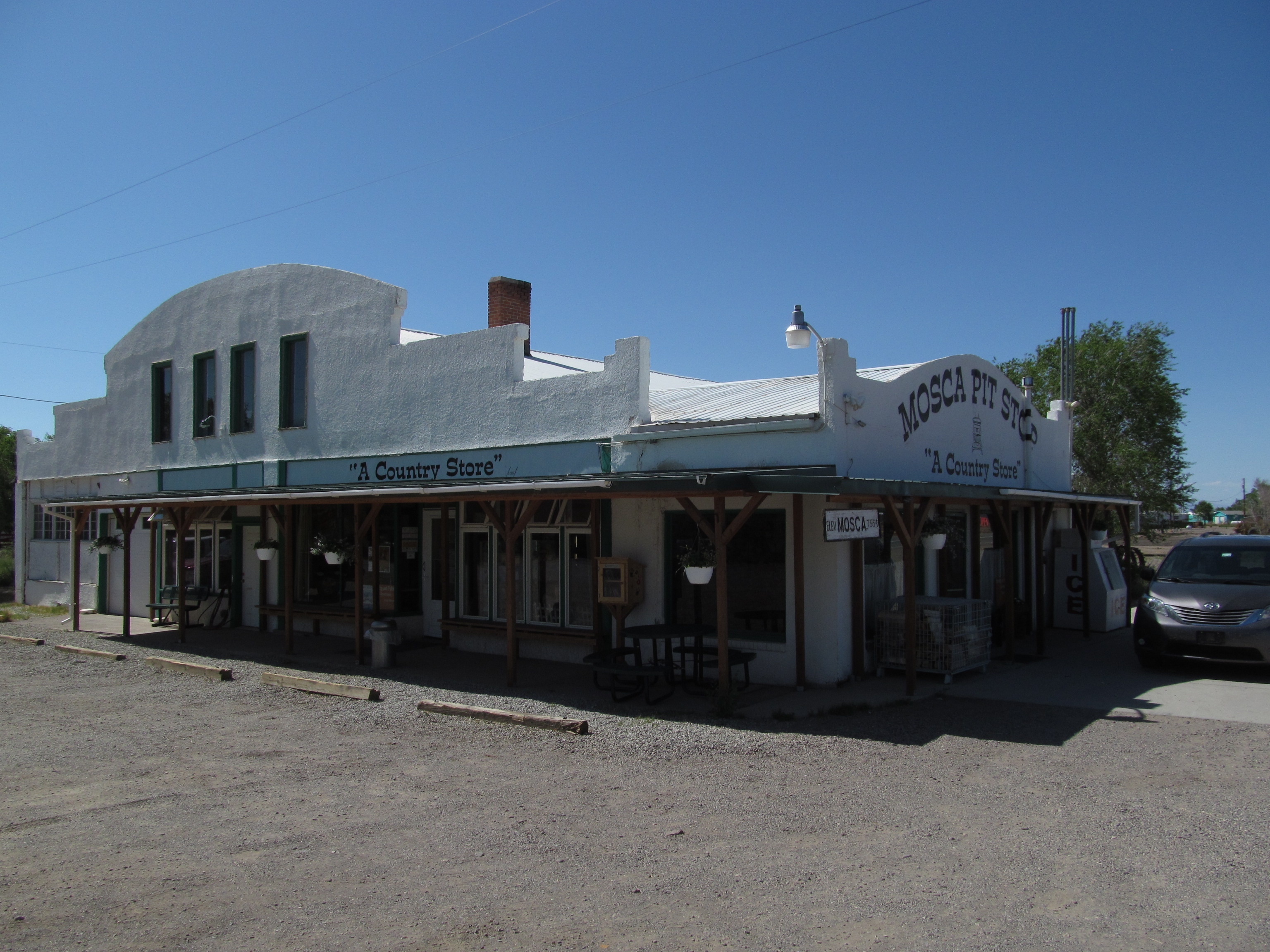
Looking at the map, I was worried about gas availability between Alamosa and Aspen, so we filled up in Alamosa, but Mosca Pit Stop had pay-at-the-pump gas and clean, cutely-painted restrooms, Moffat had a coffee house, and Hooper appears to be getting a new gas station. Hooper is also the nearest town to Colorado Gators Reptile Park (which uses warm natural springs to provide a comfortable environment for the alligators) and the UFO Watchtower.
Buena Vista is an attractive historic town on the Arkansas River and near the Collegiate Peaks. Main Street boasts a creperie (The Midland Station, all batter gluten-free) and gelateria, a roastery, a distillery, and a silver-domed building that used to be the county courthouse. The town was busy on a Saturday afternoon. Brown Dog Coffee is in a newer building on the highway, and we tried to stop there for a last pit stop before the pass on the way north, but they were closed for an employee party. Gave it a miss on the way south.
Early June is after the end of Aspen's ski season, but before summer activities start up. We got a good deal on a very nice room at Tyrolean Lodge. The room was very quiet, had a kitchenette, two queen beds and a twin bed, and was only a few blocks' walk from downtown. The lodge has no elevator, and its first floor is a half-story down from street level, second floor a half-story up, and the third floor (with highest ceilings and largest rooms) was a story and a half up. The room and the stairwells were decorated with maps and vintage ski posters. One stairwell featured a giant mosaic, probably 10 feet high, of USGS quadrangles of the region. Our room had the Raven Maps topographical map of Colorado.
Youngest son and I walked to New York Pizza (open until 2:30 am) to fetch a late dinner for the family.
Downside of our timing: the Aspen Historical Society museum was closed for installation of a new exhibit, and there were no historical tours on offer as the summer interns were in training. When I phoned to ask about self-guided historical opportunities, the man who answered the phone kindly offered to leave us a couple of maps on the front table.
Aspen is the seat of Pitkin County, and its historic courthouse is still in use. Oddly, the silver-colored allegorical statue of Justice above the front door is not blindfolded. The courthouse has hosted notorious trials involving Claudine Longet, mass-murderer Ted Bundy, Hunter S. Thompson, and Charlie Sheen.
Aspen has a memorial garden along the Roaring Fork River dedicated to John Denver, and many of his famous lyrics are carved on stones there. I learned that my children had never heard his music, which was unavoidable during my childhood.
We took a peek in the lobby of the historic Hotel Jerome. Oldest son was fascinated by a book in the lobby, Aspen: The Quiet Years, by Kathleen Krieger Daily and Gaylord T. Guenin, published in the early '90s, a collection of the stories of those who lived in Aspen after the silver boom ended and before the ski boom began. Across the street in an old house is Explore Booksellers, where my youngest son found an autographed copy of one of Rick Riordan's Percy Jackson novels.
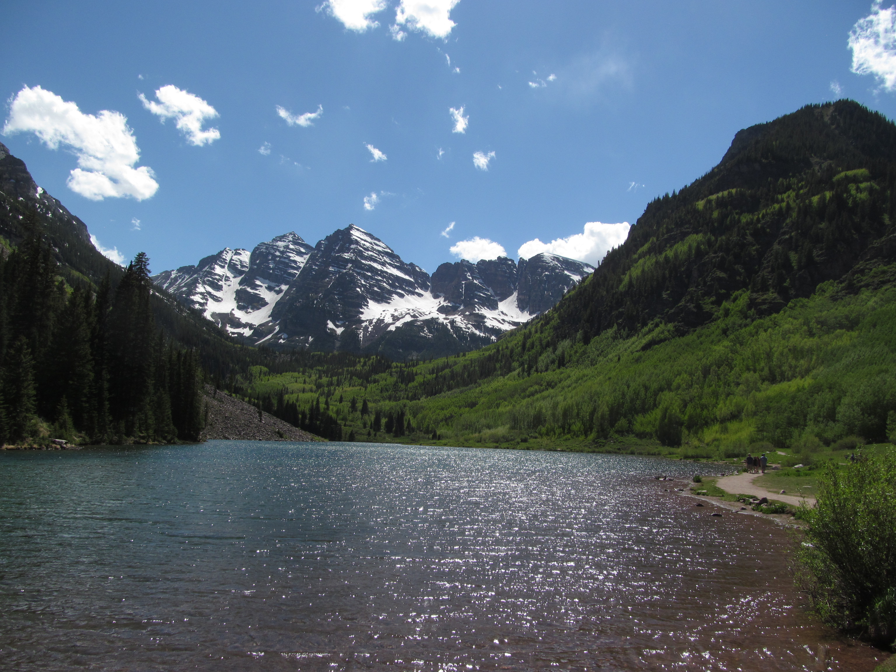
We had a lovely hike at the Maroon Bells southwest of town. The kids wanted to take it to the next level -- another three miles round trip and another 600 feet in elevation to Crater Lake. We were rewarded with views of majestic purple mountains reflected in placid lakes, the round leaves of the aspens shimmering in the breeze, and sightings of deer, marmots, and chipmunks. We were told by the lady at the tourism kiosk in Aspen that the Maroon Bells and lake were the most photographed landscape in America.
On the way back into town, we spotted the ultimate young Coloradan: A young male with a scruffy beard, riding a bicycle, wearing a stocking cap, and smoking a spliff the size of his thumb.
We followed up the mountain hike with a visit to Ashcroft ghost town, which only has a dozen buildings, but it includes an impressive two-story hotel. We spotted an antler-less moose browsing in the creek beside the road. On the way out of Aspen, we stopped at the Independence ghost town site (just east of mile marker 57), which covers a larger area, has more undisturbed ruins, and at nearly 11,000 feet above sea level is considerably more strenuous to visit. Both sites are maintained by the Aspen Historical Society and have good interpretive signs. We learned that, when heavy snowfall cut Independence off from supplies, the remaining citizens broke apart their homes, made skis, and skied into Aspen, abandoning the town forever.
We spent about the same amount per person at Matsuhisa in Aspen as we did at the Big Texan. At Big Texan that got me a 16-oz. ribeye, two sides, and a beer. At Matsuhisa that got me two pieces of sushi, two shrimp, a tiny portion of vegetables, and a glass of water in a noisy basement. A 10th Mountain Imperial Stout from Aspen Brewing Company, a good chat with the oldest son, and a brisk walk back to the hotel improved my mood considerably.
Sledding the Great Sand Dunes is a lot of work for the thrill. You rent a board or sled off-site. You walk a half-mile through loose sand just to get to the nearest dune, and then for every downhill run, you've got to walk that far up again in loose sand. At the crest of the hill, if the wind picks up, you'll be sandblasted as you attempt to get on the sled for your run. We were warned about bugs and about heat, but on this early June afternoon at 5:45 pm the sand was not hot, and the wind kept the bugs away. If you wipe out, you don't get hurt. We slogged back to the parking lot after an hour, fighting to hold onto our sleds against the wind. We made it back just before the 7 pm deadline to return our sleds to the Great Dunes Oasis just outside the park gate and had dinner in their mediocre cafe. Enough sand had collected in my back pockets that I felt like I was sitting on a roll of dimes as we drove to our hotel for the night.
The Holiday Inn Express in Raton keeps its pool and guest laundry open 24/7. Their lobby is decorated like a mountain lodge with big leather sofas and a fireplace and a stack of board games. A sign by the desk notified evacuees from the fire near Cimarron that the Red Cross had meals available for them. In addition to the usual breakfast items, there were diced green chiles you could add to your eggs or your biscuits and gravy. A cheerful lady named Annie was in charge of the breakfast room. She told the kids to stay in school; she had dropped out after 11th grade to help her family and never finished high school, which limited her career options. She said she had spent her entire life in the Raton area.
Did you know there is a field of volcanoes just across the state line in New Mexico? The most accessible is the long-extinct cinder cone of Capulin Volcano National Monument. You can walk a paved trail down into the vent or take a mile-long hike around the rim, from which you can see dozens of shield and cinder cone volcanoes for miles around. Black Mesa, on which sits Oklahoma's highest point, is thought to have been formed by lava flows from this volcanic field.
Just north of Capulin Volcano is the tiny town of Folsom, New Mexico. In one of the few remaining historic buildings, once a general store, is the Folsom Museum, open daily during the summer, a well-organized and diverse collection of historical artifacts: Gramophones, canned food, a telephone switchboard, kitchen equipment, saddles, law books, a bank vault and safe. They've got drinks, ice cream, and snacks for sale, the only place for miles around. We enjoyed our visit.
Ever wonder why the New Mexico border with Oklahoma is a couple of miles east of the New Mexico border with Texas? I've found two explanations: The first is that the Texas / New Mexico border was badly surveyed in 1859, locating New Mexico's southeast corner some four miles west of where it should have been. The other explanation is that Oklahoma Territory's western border was established at 103 degrees west of the Greenwich Meridian, while the Texas Panhandle's western border was set at 26 degrees west of the Washington Meridian, which is at 77°3'5.194" west of Greenwich. The difference of 3 minutes, 5.194 seconds of longitude at 36.5 degrees north of the equator amounts to about 2.8 statute miles, which is actually a bit more than the distance as measured on the map.
There's even less to Kenton, Oklahoma, but the drive there took us past some interesting canyons and traces of the Cimarron Cutoff of the Santa Fe Trail. Kenton has an old mercantile store that was closed on Sunday afternoon, a handsome stone Methodist Church, a handsome white Baptist Church, and signs advertising some B&Bs near by. Black Mesa is visible in the distance. Heading east of town, we encountered a pronghorn antelope walking in the road, and we managed a few good photos of him as he scampered off into the surrounding fields.
The Panhandle is longer than you might realize: 167 miles along the southern border, 166 miles along the northern border, and it takes a long time to get all the way across. Guymon, seat of Texas County, is the Panhandle's metropolis, with a daily paper and a community theater company that performs at the historic American Theater, where the marquee advertised the latest production, Spamalot.
I wish car navigation systems had a button that would route you on the business route or historic route through a town. I was sorry to have missed downtown Woodward. We stopped for dinner west of town on 412, but I missed the turn to take us down Main Street.
I wish car navigation systems gave more detail. Zoom out to get the big picture, and the details go away. Some of the roads we traveled wouldn't show up except at the three highest zoom levels. Would it be that bad to show thin grey lines for minor roads even at lower zoom levels, to give you an idea of where civilization exists? They're stingy with place names, too, and they disappear and reappear inconveniently, failing to provide important information such as the name of the next town on the route. Of all the rental cars I've driven in recent years, only the Ford nav system provided the level of detail I want.
It is the first day of DST in the United States and everyone is groggy and cranky and wondering why we bother with changing the clocks twice a year. There are the usual calls to go to DST and stay there forever, or stay with standard time forever.
The last two Novembers I've spent some time in a place that doesn't have DST: the Australian state of Queensland. Australia has three principal time zones: Australian Western Standard Time (GMT+8 hours); Australia Central Standard Time (GMT+9.5 hours); and Australian Eastern Standard Time (GMT+10 hours). But from the first Sunday in October to the first Sunday in April, the south-central and southeastern states go on DST, while Western Australia, the Northern Territory, and Queensland remain on standard time. During this period you have the strange situation where you can drive 70 miles due south of Brisbane, and it's suddenly an hour later.
On November 30, late spring in Brisbane, Queensland's capital, dawn (civil dawn) comes at 4:18 am and dusk ends at 6:54 pm. On the longest day of the year, dawn comes at 4:23 am and dusk ends at 7:09 pm. For most people, that means 90 minutes or more of daylight while you're still trying to sleep, and yet it still gets dark not long after supper. Many Queenslanders would like to move that hour of early morning light to a more useful time.
As bad as at is to have the sky brightening when it should be oh-dark-thirty, Brisbane, a subtropical city with a relatively small fluctuation in the length of days over the course of the year, doesn't get the worst of it. The farther you get from the equator, the higher the latitude, the longer the days and the more sunshine is wasted. In Hobart, Tasmania, dawn would break on the solstice at 3:53 am without DST, but DST pushes that to 4:53 am and pushes nightfall from 8:24 pm to 9:24 pm -- more time after work for outdoor activities.
So if the problem is the distribution of sunlight around the work day, is there another way to solve it?
Idea #1: Move to DST permanently. But then, when you get to late autumn and winter, there's no sunlight at as people are going to work and school. If we still had DST in December, dawn would break at 8 am in Tulsa.
Idea #2: Stay on standard time permanently and move business hours to improve the amount of daylight after work. The challenge here is unpredictability. Some businesses would adjust hours, some wouldn't.
Idea #3: Designate sunrise on any given day as 6 am and reckon hours from that point of reference. A business that opens its doors at 8 am would always be starting two hours after sunrise. One problem with that idea is the same problem that led to the creation of time zones in the first place, when every town measured time by local noon; drive a few miles east or west and your watch would suddenly be off by a minute. Measuring time by sunrise would add a north-south variation to time calculation. It was bad enough to have local time variations when we could travel at 60 mph, but imagine the chaos dealing with local time variations now that we can communicate at the speed of light.
It turns out that moving clocks forward an hour in the spring and back in the fall is a pretty good compromise between all these competing concerns.
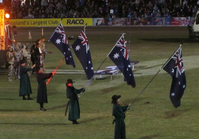
Two Augusts ago I was in the stands at Brisbane's Exhibition Grounds waiting for the evening performance at the "Ekka" -- Queensland's state fair -- to begin. The crowd stood at attention as a cowgirl on horseback rode around the arena waving a huge Australian flag. The band played and the crowd sang the National Anthem, "Advance, Australia Fair."
There's something about a patriotic display that brings me close to tears, even when it's directed at some other country. Whether it's the crowd at the Last Night of the Proms waving the Union Jack and singing "Land of Hope and Glory," a Welsh men's choir belting out "Men of Harlech," that scene in Casablanca where the customers at Rick's Cafe spontaneously and defiantly sing the "Marseillaise," a group of Augustine Christian Academy students singing along with "Hatikvah" in Israel's Independence Hall, Dorothea Mackellar reciting her poem, "My Country" (see below) -- I get choked up just thinking about it. Love of country is dulce et decorum, sweet and fitting, a sentiment that ought to be honored and cultivated.
But patriotism is everywhere under attack. The advancement of human rights, the extension of human life, and the increase in the standard of living resulting from the spread of western civilization is ignored and the inevitable flaws and failures of any human endeavor are magnified in what conservative Australian political blogger Stephen Cable calls "a black armband view of our past."
We have seen this here in Oklahoma, as an activist convinced the elementary school principals of the Oklahoma City school district that they shouldn't hold re-enactments of the 1889 Land Run, based on the false claim that the run involved murdering Indians. Once nearly all of the schools had dropped the event, the school board voted to ban the celebrations permanently. This in a city that came into existence with an instant population of 10,000 people by sundown the day of the run! In fact, the land had been purchased from the Muscogee Creek tribe pursuant to the post-Civil War 1866 treaty, which also freed slaves owned by the Creeks, granted the Freedmen tribal membership, and granted amnesty to the Creeks who had fought with the Confederacy against the United States. Portions had been allocated to other tribes; the remaining Unassigned Lands were opened for homesteading by land run on April 22, 1889. Oklahoma children are being cheated out of celebrating a unique part of their state's history -- a fun celebration that involves running around outside in pioneer costumes on a spring day -- because of a false narrative pushed by a grievance-monger.
This Friday, January 26, is the 230th anniversary of the date in 1788 that the Governor Arthur Philip of the First Fleet came ashore in Sydney Cove and raised the Union Flag, claiming the continent for the United Kingdom and establishing the first European settlement there. It is an official holiday known as Australia Day, celebrated like America's Independence Day with parades, cookouts, fireworks, flag-flying, and backyard cricket. (All right, the latter doesn't really apply to our Independence Day.) Australia Day falls at the end of the summer holidays and the beginning of a new school year.
Here in Tulsa, the Tulsa Buffaloes, 2017 champion of the US Australian Football Association, will celebrate Australia Day at Veterans Park, their usual venue, on Saturday, January 27, 2018, noon to 4 pm, with a sausage sizzle, some football, some cricket, and followed by further celebrating at Fassler Hall. RSVP and bring a side other than chips.
In recent years, Leftists, intent as they are on destroying civilization so that their socialist utopia can rise from the ashes, have been arguing that Australia Day should be a day of mourning, not celebration, and cultural institutions are beginning to fall in line. This year, Triple J, the state-funded pop music radio network, decided to change the date of their Hottest 100 countdown of listener-selected Australian songs, an Australia Day tradition, because of pressure groups who consider the day offensive to aboriginal Australians. The news release about the move stated, "it was clear most people want the Hottest 100 to be on its own day when everyone can celebrate together," implying that Australia Day isn't something that every Australian can cheer.
Private broadcaster Triple M has stepped in the gap with an "Ozzest 100 countdown." The new Australian Conservatives party responded with a Spotify playlist of 100 songs by Australian bands, leading off with Men at Work's "Down Under," but party leader Sen. Cory Bernardi reported that Spotify briefly pulled the playlist after someone falsely complained of offensive content.
In a recent op-ed, Tony Abbott, a member of Parliament and former Prime Minister of Australia, defended January 26 as the date of Australia's national celebration:
"All right, but apart from the sanitation, the medicine, education, wine, public order, irrigation, roads, a fresh water system, and public health, what have the Romans ever done for us?" asks the John Cleese character in the classic film Life of Brian. It's worth asking the same question of the British settlement of Australia at the same time as we acknowledge the dispossession of the original inhabitants.Sure, not everything's perfect in contemporary Australia; and it's possible that Aboriginal life could have continued for some time without modernity bursting upon it, had governor Arthur Phillip not raised the Union flag and toasted the king on January 26, 1788, but it's hard to imagine a better Australia in the absence of the Western civilisation that began here from that date. The rule of law, equality of the sexes, scientific curiosity, technological progress, responsible government -- plus the constant self-criticism and lust for improvement that makes us so self-conscious of our collective failings towards Aboriginal people -- all date from then; and may not have been present to anything like the same extent had the settlers fanning out from Sydney Cove been other than British....
The Australia of those days had all that era's faults: women were kept in their place; dissent was barely tolerated; different races were discriminated against; not everyone could vote; few had access to good education and health care. But the spirit that animated the society thus established has subsequently addressed all these issues, not perfectly, but as well as anywhere.
The surest sign of our success (and of the decency and magnanimity that characterises our people) is that the vast majority of Aboriginal Australians are as proud of our country as they are of their indigenous heritage. How could any Australian's heart not beat with pride?
There are 364 other days of the year when we can wear a black armband and strive to overcome our national failures.... But this Friday I will gladly join millions of my fellow Australians to declare my faith in what, to us, is surely the best country on earth.
While I can't agree with Abbott's final statement, I can agree that the world is a better place for the spread of British civilization across the planet. No country is perfect, no country can be perfect this side of the Great Judgment. ("And there's another country I've heard of long ago....") Those countries that have remained faithful to the notions of fair play, rule of law, sanctity of contract, civil liberties, and human dignity that have their roots at Runnymede in 1215 enjoy stability, freedom, peace, and prosperity that is hard to find anywhere else in the world.
Even though it isn't my country's celebration, Australia Day commemorates the arrival of the civilization that turned a continent into a free, peaceful, and prosperous home for over 24 million people. It's a bit more of a nanny state than I like, and the same progressive blight that afflicts our land has spread there as well, but it's still a beautiful place with friendly, hardworking people, thriving cities and towns, and unrivaled landscapes. It's the country that gave the world ANZACs, Vegemite, Bill Kerr, The Seekers, Joan Sutherland, the novels of Nevil Shute, Aussie Rules Football, Olivia Newton John, the Queenslander house, Yvonne Goolagong, beetroot on burgers, the Crocodile Hunter, The Wiggles, Strictly Ballroom, and Dreamfarm kitchen gadgets.
"The Lucky Country," they call it, but it's more accurate to call it a land abundantly blessed by God, not only in its unique fauna and flora, beaches, mountains, deserts, and valleys, but in the civilization that gained its first foothold 230 years ago today. That's worth celebrating, and I'll be happy to raise a bottle of Bundaberg Ginger Ale in honor of the day.
MORE: The Seekers perform "I Am Australian," "Georgy Girl," "Waltzing Matilda," and "Advance, Australia Fair" at the Grand National Final for the Australian Football League at Melbourne Cricket Grounds.
UPDATE, Australia Day 2020:
The debate about the proper date of a national celebration continues. Kurt Mahlburg writes:
It was much later still, in 1946, that the state and Commonwealth governments agreed to celebrate Australia Day nationally on January 26th. Exactly three years later, Australian citizenship was created with the Nationality and Citizenship Act.Since that time, people of every race--our indigenous brothers and sisters included--have no longer been regarded as British subjects, but instead as proud Australians. Citizenship ceremonies are still a big part of Australia Day celebrations each year, with over 16,000 becoming citizens again in 2020.
In other words, Australia Day is intended to celebrate what unifies us, not what divides us. We gather at barbecues and beaches and parades and fireworks displays to celebrate the best of Australia, not our worst....
I empathise with any indigenous Australians who connect this date symbolically with "white invasion". But to any who feel this way, I would simply plead that that's not what is being celebrated by anyone on January 26th.
There's no way that 78% of Australians who are proud to celebrate Australia Day on its current date are racists. Unless there is evidence to the contrary, it's only fair to assume that the vast majority of them simply love this country--and all of the great peoples and cultures that make our nation what it is today.
Mahlburg links to a recent interview with Jacinta Nanpijimpa Price, a councilor in the city of Alice Springs, Northern Territory, who is of mixed indigenous and British convict heritage, says that Australia Day is a day to "celebrate what we've all achieved together." She calls it "emotional blackmail" when people accuse those who celebrate Australia Day as celebrating genocide and cultural destruction.
What Stephen Chavura tweeted would apply to the black-armband types in America as well:
If you tweet #AlwaysWasAlwaysWillBe please sign your house and land over to your local historic indigenous tribe. By your own words as long as you don't give it back you're stealing from indigenous Australians and no better than the original invaders. #talkischeap
I'll get back to the charter amendment proposals in a couple of days, but we have some historical commemorations that deserve our attention. There's the big one -- the semimillenial celebration of Luther's 95 Theses and the commencement of the Protestant Reformation -- but 100 years ago today there were a couple of events of lasting significance involving the Holy Land. One of those events was the last great cavalry charge in the history of warfare, which broke the Ottoman line of defense and opened the door for the conquest of Palestine by British, Australian, and New Zealand troops.
Beersheba is the ancient city known as the southern end of proverbial description of the extent of the ancient land of Israel -- "from Dan even unto Beersheba." It was at Beersheba that Abraham and Abimelech, king of Gerar, made a covenant, by which the place was named -- Well of the Oath (Genesis 21:31). The name could also mean the Seven Wells dug by Isaac (Genesis 26). The modern city of Beersheba, to the west of the tel, was founded in 1900 as a southern outpost of Ottoman Palestine, strengthening the Turks' claim to the Negev against British control of the Suez Canal and the Sinai Peninsula. Today the metro area has a population of about a half-million people. To the east of the modern city is Tel Be'er Sheva National Park, a UNESCO World Heritage site, where you can walk down into an ancient cistern from King David's day.
In 1917, Beersheba was one end of a defensive line that ran to Gaza on the coast, protecting Ottoman and German control of Palestine. In March and April, Allied forces twice attacked Gaza and twice failed to take the city. A long stalemate ensued, which included trench warfare, mounted patrols, aerial reconnaisance and dogfights, and training and reorganization on both sides of the line.
That reorganization included a change of leadership on the British side and a change of strategy, aided by some detailed local knowledge. Historian Barry Shaw explains in a Jerusalem Post story:
Under Gen. Sir Archibald Murray, the British army was badly beaten twice at the battles for Gaza.Murray tried to put a brave face on his humiliating defeat by misrepresenting the casualty figures and claiming that "it was a most successful operation, the fog and waterless nature of the country just saving the enemy from complete disaster."
The War Cabinet did not see it that way, and Murray was relieved of duty, to be replaced as commander of what was called "The Egyptian Expeditionary Force" by Gen. Edmund Allenby.
This no-nonsense military leader, known as "The Bull" for his build (he stood 194 cm. tall) and demeanor, received instructions from British prime minister David Lloyd George, a Welsh Baptist Zionist, to give the British public a gift by taking Jerusalem by Christmas.
Allenby adopted a new tactic, military deception, by lulling the enemy into thinking he would follow Murray's example and launch a third major assault on Gaza.
Instead, aided and advised by a Palestinian Jew and a Christian Zionist intelligence officer, Allenby was persuaded to swerve south of Gaza and attack Beersheba because, as Aaron Aaronsohn, an agronomist from Zichron Ya'akov, told him, "that is where the water is."
Aaronson's research convinced him that large reserves of water lay hidden under the hot desert surface of the Negev. As he pointed out to a receptive Allenby, without sufficient water for his hundreds of thousands of men, tens of thousands of horses and camels and his motorized vehicles, he had no chance of winning the Palestine campaign.
Aaronsohn also knew the trails and wadis that would allow Allenby's massed troops to negotiate their way from Egypt to Beersheba without getting bogged down in the soft desert sands and for his advanced troops to approach Beersheba relatively undetected.
Shaw describes the battle as Britain's first victory in the Great War after four humiliating defeats to the Turks.
An article on the History of War website explains the strategic importance of Beersheba:
The main Turkish defensive line ended at Kauwukah, ten miles to the north west of Beersheba. There was a simple reason for this. The countryside to the west and south of Beersheba was entirely waterless. Any attacking force would have to carry its own water, and be confident that it could capture Beersheba in a single day, for the only water in the area was within the town. The biggest danger was that the Turks might have time to destroy the wells within Beersheba, forcing the attacking force to retreat back towards its water supplies.The Turkish defences of Beersheba were strongest towards the south and west. There they had a line of trenches, protected by barbed wire, supported by strong redoubts, all constructed along a ridge. To the north and east the defences were much weaker, and crucially lacked any wire. No serious attack was expected from the area of rocky hills east of the town. Beersheba had just been designated as the headquarters of a new Turkish Seventh Army, but on 31 October that army had not yet come into being. The town was defended by 3,500-4,000 infantry, 1,000 cavalry with four batteries of artillery and fifty machine guns.
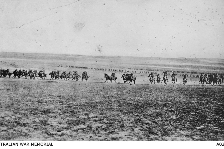
Early on the morning of October 31, 1917, the British guns began the attack on Ottoman positions. By mid-morning the attack on the tel, a key defensive position, had begun, and by mid-afternoon New Zealand ground forces charged up the tel with bayonets and took it. Not long after, the Australian 12th and 4th Light Horse Regiments led the charge for the assault on the town:
The 4th and 12th Australian Light Horse Regiments drew up behind a ridge. From the crest, Beersheba was in full view. The course lay down a long, slight slope which was bare of cover. Between them and the town lay the enemy defences. The 4th was on the right; the 12th was on the left. They rode with bayonets in hand. Each drew up on a squadron frontage. Every man knew that only a wild, desperate charge could seize Beersheba before dark. They moved off at the trot, deploying at once into artillery formation, with 5 metres between horsemen. Almost at once the pace quickened to a gallop. Once direction was given, the lead squadrons pressed forward. The 11th Australian Light Horse Regiment and the Yeomanry followed at the trot in reserve. The Turks opened fire with shrapnel. Machine guns fired against the lead squadrons. The Royal Horse Artillery got their range and soon had them out of action. The Turkish riflemen fired, horses were hit, but the charge was not checked. The Lighthorsemen drove in their spurs; they rode for victory and they rode for Australia. The bewildered enemy failed to adjust their sights and soon their fire was passing harmlessly overhead. The 4th took the trenches; the enemy soon surrendered. The 12th rode through a gap and on into the town. Their was a bitter fight. Some enemy surrendered; others fled and were pursued into the Judean Hills. In less than an hour it was over; the enemy was finally beaten.
Crucially, the wells were intact when the Allies took the city.
By the end of the year the Allies had taken Jerusalem. The conquest of Beersheba was an turning point in the war against the Ottoman Empire, and a landmark of Australian military history.
Read more, and see photos of the charge:
- The Light Horse Charge at Beersheba
- The taking of Tel el Saba, or the role the New Zealanders played in the taking of Beersheba. By Steve Butler
- Col. Jack Davies personal account of the charge at Beersheba
- Photographs of Beersheba by Francis Gillard Rathkey
- A photograph of the charge
- Reenactment of the battle in western Queensland
- The Beersheba Living Museum 5th Light Horse Regiment in Maleny, Queensland, opened its doors for the first time earlier this year.
- ABC: Descendants of the Australian Light Horsemen retrace their ride in Beersheba
- ABC video: Remembering Indigenous [Aboriginal] soldiers at the Battle of Beersheba
MORE: Video from the Prime Minister of Israel's office of today's commemorations, including a dramatic haka (Maori war dance) in memory of the New Zealand soldiers who died capturing Tel Be'er Sheva.
If you read my earlier entry about cricket in Australia, you're likely champing at the bit, wondering where you can see this high-scoring sport close to home.
In the month of January, your best opportunity is while seated on your sofa. NBC Sports Network (channel 317/1317 on Cox Tulsa cable) is airing one KFC Big Bash League game every week through the end of the season, plus the semifinal and final matches. This is TV-friendly Twenty20 cricket -- twenty overs per side, with an overall three-hour time limit. Teams are penalized if they fail to complete their bowling innings within 90 minutes; the Brisbane team faces the suspension of their team captain for going five minutes over. The Brisbane-Perth match, which aired live at 2:30 am this morning, will be rebroadcast Thursday, January 12, 2017, at 11:00 am Tulsa time. It's a very different fan experience, too: In contrast to the empty stands for the Sheffield Shield matches I watched, the Gabba was sold out for this match, which featured flashy scoreboard graphics, music between overs, and a swimming pool overlooking the pitch.
But when our weather warms up, there will be an opportunity to see live and local cricket. Two Tulsa clubs, the Greater Tulsa Cricket Club and the Green Country Cricket Club, participate in the Two-State Cricket League (TSCL), along with five clubs based in Wichita, three in Oklahoma City, and one each in Lawton, Stillwater (associated with OSU), and Salina, Kansas. Gauging from the names on the roster, it appears that one of Tulsa's two clubs is predominantly Indian and the other Pakistani. Both teams play at Ute Park, south of Jackson Elementary School at Ute St. and N. Pittsburg Ave. (A well-tended wicket shows up clearly on satellite photos.) The 2017 schedule is not yet posted, but last year's list of fixtures indicates that they play 35-over cricket from early April until October and Twenty20 cricket in October.
As I learn more details, I'll keep you posted.
NOTE: The fifth day of the third test match between Australia and Pakistan began at 5:30 pm Tulsa time, Friday, January 6, 2017. You can listen online (free with registration) or watch the ball-by-ball description (no registration required) here. Australia finished its second and final innings late yesterday with a 464 run lead. Pakistan must either catch up to win (very difficult), or manage to keep batting until the end of the day for a draw (possible). UPDATE: Australia managed to get all 10 wickets within 80 overs, giving up only 244 runs. That's only three more runs than Australia gained for two wickets. Only one Pakistani batsman managed more than 50 runs. Final total: Australia 779, Pakistan 559.
NBC Sports Network (Cox Tulsa channels 317/1317) is airing ten KFC Big Bash League games this season, including semifinals and finals later this month. The next opportunity to watch is the Brisbane Heat vs. the Perth Scorchers, on January 11, 2017, 2:30 am Tulsa time, with a rebroadcast on January 12 at 11 am Tulsa time.
Imagine a variant on baseball:
- Instead of scoring a run when you pass home plate, you score a run every time you reach a base.
- Instead of four bases, there are only two.
- Instead of the base consisting of a square pad you have to step on to be safe, there's a line you have to cross.
- There's always one batter and one runner on first.
- The pitcher pitches six balls from first base to home plate. Then home plate becomes first base and vice versa, the batter becomes the runner and vice versa, and a different pitcher pitches six balls in the opposite direction from the previous 6.
- "Pitcher" is a misnomer. He can best to bounce and spin the ball off of the ground. Let's call him a bowler instead.
- There's no such thing as a foul ball.
- If you hit the ball, you don't have to run, if you don't think you have time to run to the other base before the ball comes back.
- Instead of standing beside home plate, the batter stands in front of a thing that looks like three croquet stakes next to each other, with two little wooden tops resting on top of them.
- Getting out involves someone catching a batted ball on the fly; a fielder hitting the croquet stake things with a ball, hard enough to knock the wooden top things off, while runners are between the lines; the bowler hitting the croquet stake/wooden top assembly with the ball, or the bowler hitting the batter's leg with the ball if the ball would otherwise have hit the croquet stake/wooden top things.
- Instead of an outfield wall, there's a rope, at least 225 feet from the batter. Hit a ball over it on the fly, you score six runs. Hit it over on the ground, you score four runs.
- If you hit a double or a home run, you get to keep batting, at least until it's time for the bowling to change direction.
- One team keeps batting until 10 of their 11 batters are out. That's an innings. Each team gets two inningses.
- You play for six hours a day, stopping a couple of times for lunch and snacks, for four or five days.
- No pinch hitters, no pinch runners, no substitutions (except for illness or injury).
- And if both sides haven't finished their inningses by the scheduled end of the game, it's a tie, no matter how big the lead.
This, then, is cricket.
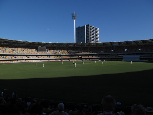
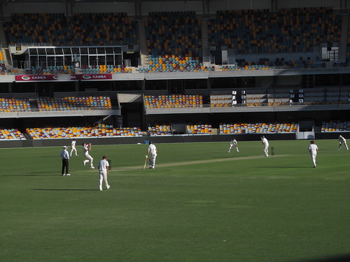
I was delighted to hear that there would be a Sheffield Shield match at the Brisbane Cricket Ground while I was in town, and my schedule would allow me time to take in some of the match. Sheffield Shield is the name of the annual double-round-robin competition between state teams, and this four-day match would pit the Queensland Bulls against the New South Wales Blues. Better yet, there was no fee for admission, so I could watch as much as I had time for without feeling I'd wasted money on a ticket.
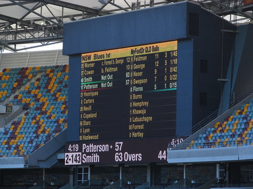
Sheffield Shield is just one level down from international competition (aka Test cricket), but levels of play aren't mutually exclusive the way they are in American baseball. A Shield team is more like a statewide all-star squad, and the team that competes in international tests is like the Olympic team. Steve Smith, captain for Australia, also captains the NSW Blues and plays for the Rising Pune Supergiants in the Indian Premier League. Other international players also play in Australia's Big Bash League, a shorter form of cricket. Smith was batting while I was there, and the Blues and Bulls combined included at least a half-dozen players that are also on the national team: Dave Warner, Usman Khawaja, Mitchell Starc, Josh Hazlewood, and Nathan Lyon.
The state teams and national team each have a panel of selectors who pick which players will take the field for the next match. After a string of losses, the selectors take as much heat, if not more, than the players. After Australia lost the first two test matches in a series of three against South Africa last month, the chairman of selectors resigned. A revamped board of selectors called up some new players, based on their performances in this season's Sheffield Shield, and the recharged Aussies managed to win the third and final test against South Africa, a series of one-day internationals against New Zealand, and the first test against Pakistan. Currently Australia is ranked second among the 10 nations that play test cricket, trailing India; the two teams will meet in a four-match series in India in February and March.
I said the match was held at the Brisbane Cricket Ground, but if you were to ask a local for directions using that name, you'd likely get a blank stare. At five syllables, that name, while technically accurate, is way too long for an Aussie to trouble himself to speak it in full. Locally, the stadium is known as The Gabba, which is short for Woolloongabba, the Brisbane district in which it's located.
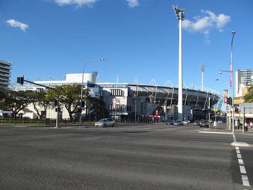
There has been a cricket ground at the site of The Gabba since 1895, but the current 42,000-seat stadium is the product of a staged redevelopment from 1993 to 2005 that replaced historic grandstands and buildings with a round stadium, the sort of thing that American cities built in the US in the 1970s to house both baseball and football teams (e.g. Busch Stadium, Three Rivers Stadium, Riverfront Stadium). I heard a cricket commentator on the radio refer to the redeveloped Gabba as "soulless." It certainly lacks any sense of history.
Before the redevelopment, there was a grassy berm known as "The Hill" where rowdier fans could let loose, and kids could run and play:
The Gabba hill was a place where you could stretch out, relax, drink full strength beer, watch some cricket, or even have a sleep late in the day if you needed it. And for those seated in the stands, when the game out in the middle was meandering along, you could always rely on the hill to provide some entertainment....I remember sitting on the hill at the Gabba while my grandpop drank tallies and us kids played with an old bat and tennis ball.
The oval fits in between two major streets, but the stadium stands were a little too big. Rather than reroute the streets, the upper-levels of the stands overhang them.
On this October day in 2016, only one gate was open for the match. A stadium staffer handed me a roster of players and directed me to the handful of sections that were available. The ground-floor concourse looked the same as a US multipurpose stadium, except for the off-track betting parlor. A single concession stand offered soft drinks, hot dogs, chips (fries, that is), low-point beer, and mixed drinks. (They have pre-mixed cans of Bundaberg rum or Jack Daniels or Jim Beam and cola, diluted to 4.6-5.0% ABV, just a little stronger than 3.2 ABW beer.) Some sections were marked as no-alcohol zones.
Perhaps 200 fans were scattered around the open sections. The sky was cloudless. Qantas and Virgin Australia jets zoomed overhead on final approach to Brisbane airport several miles north.
The quiet was striking. No announcer on the PA system. No music between overs. Just conversation, interrupted by the crack of bat on ball and applause when someone hit for four or for six. The crowd rewarded a century -- a batsman reaching 100 runs -- with sustained applause and a standing ovation, even if it was a batter for the opposing team. Once in a great while, there'd be a cry of "howzat!" from the fielding team (the traditional way to appeal to the umpires to call a batter out), followed by a groan from the crowd in reaction to the umpire's decision. Over three separate visits to the stadium, I heard young tourists speaking French, middle-aged men discussing buying a television, train journeys, and the new female clerk at the 7-Eleven, a noisy, vulgar heckler (who was escorted out), and long-time cricket fans actually discussing the players and action on the field.
The scoreboards on either side of the stadium displayed the rosters for each team with batting and bowling stats for the current innings.
Cricket is a challenging sport for spectators. The closest seat in the stadium is nearly as far from the wicket (about 250 feet) as a Fenway Park bleacher seat is from home plate (just over 300 feet). With few exceptions, plays don't develop over time but are almost instantaneous: A ball is bowled, the batter strikes, the ball is caught or stopped, all in a matter of seconds. Unless you have very keen eyes, you're dependent on the reaction of the fielders, a signal from the umpires, or a change on the scoreboard to know what just happened. Watching on TV, where the cameras can zoom in on the action, and where you can watch instant replays and hear play-by-play commentary, makes the action easier to follow. The exceptions are boundaries, particularly when there's a chase to see if a fielder can stop the ball before it crosses the rope; and run-outs, when the batters are trying to stretch a hit into as many runs as possible -- a fielder throws the ball at the wicket to knock off the bails while the runner is between the lines.
The biggest challenge to drawing a crowd is the sheer length of the games. Unless you're retired, you just don't have time to watch a match that runs for six hours per day over four or five days. Cricket organizations have tried to adjust to modern tastes by playing day-night cricket, starting at 1 pm instead of 10 am, pushing the final session into the evening, under the lights (with a pink ball that's easier to see), and by offering shorter forms, like one-day internationals, where each team is limited to 50 overs (300 balls), or Twenty20 cricket, in which the limit is 20 overs (120 balls) a side, a game that can be finished in roughly three hours, the length of a longish baseball game. The KFC Big Bash League plays Twenty20 cricket in eight cities, one in each state capital plus a second team each for Melbourne and Sydney. Last year, the Brisbane Heat drew 29,353 fans on average, despite a 6th place finish. This past Tuesday, a match against the Sydney Sixers brought 32,371 fans through the turnstiles.
Compare that to 26,343 for the first day of the first test against Pakistan at the Gabba last month. As the match continued, attendance declined and then plummeted: 23,344 on day 2, 20,915 on day 3, 4,890 on day 4, and 2,593 on the final day. Australia had finished batting on day 3, and rain shortened day 4, but Pakistan finished strong and came close to catching up, only to be all-out early on day 5, when bad weather threatened again.
But long-time cricket fans worry that short-form cricket, which is becoming the norm for school matches, is ruining players for the traditional game. Twenty20 cricket puts a premium on swinging for the fences at every opportunity. In traditional cricket, patient shot selection is key to staying at bat and running up the score. If you hit twelve balls in a row on the ground and never budge from the crease, that's OK -- you've defended your wicket.
Traditional cricket adds more strategy to the game: The weather forecast, bowler fatigue, the changing condition of the ball and the pitch, the effect of sunlight, shadow, and stadium lights, the time remaining, all play into the captain's decisions about whether to bat or defend, when to "declare" (end an innings early, before 10 wickets have fallen), and whether to require a follow-on (a team leading by 200 or more runs after the first innings can require the trailing team to hit first in the second innings, increasing the likelihood that the match will be completed in the allotted time, avoiding a draw, and possibly avoiding the need to bat a second time).
The three formats for cricket are different enough that separate statistics are kept for each, even though many players participate in all three. Sheffield Shield matches are classified alongside Test matches, as they only differ in running four days instead of five.
I became fascinated enough with the sport that I returned to the Gabba for a later day of this match (stopping in to watch a few overs while my laundry was drying in a nearby laundromat) and again with my family a month later, to see Queensland against South Australia. I watched New Zealand wrap up its successful home series against Pakistan on TV and enjoyed listening to the Australia-New Zealand series of One-Day Internationals on the radio, as Mitchell Starc, a solid bowler and batsman, knocked one six after another. At the moment, I have to settle for listening to the Pakistan test series online, via cricket.com.au.
MORE: I found these links helpful for understanding the game. It's an iterative process, like learning a new language. Read a bit, watch a match, read some more, watch with more understanding.
Grammar:
- Cricket Explained: An American Viewpoint, by Jeff Tucker
- Cricket for Baseball Fans, by Cheryl Morgan
Dialectic:
- BBC Guide to Cricket Fielding Positions: Click the diagram to learn where mid-off, fine leg, deep cover, and third man are, and why they matter
- Understanding Cricket Statistics, by Cheryl Morgan: What's meant by "strike rate," "economy rate," and other frequently cited stats; how charts are used to illustrate game play
Rhetoric:
- Understanding Cricket Commentary, by Cheryl Morgan: Helpful for understanding how radio commentators explain bowling technique, where the fielders are, and where the ball goes when its hit
A message from the Prime Minister of Israel from the courtyard of the International Christian Embassy in Jerusalem:
To all of our Christian friends around the world, Merry Christmas and a Happy New Year. I send you these greetings from Jerusalem. I'm standing in the courtyard of this magnificent International Christian Embassy. I'm so proud of our relations with our Christian brothers and sisters. I wonder for many of you if you remember the experience you had when you first visited Israel, when you saw the Church of the Holy Sepulchre or the Via Dolorosa or the Sea of Galilee or Nazareth. I'm sure it moved you deeply.And it moves us deeply to have this bond with you because we all know that this land of Israel is the land of our common heritage. It changed the story of humanity, it changed civilization. What a magnificent heritage it is. Yet, we also know that it is under attack these days, that the forces of intolerance, of barbarism that attack all religions attack Christians with particular vehemence. We stand with you and I'm proud of the fact that in Israel, this is the one place in the Middle East that the Christian community not only survives but thrives and it's no accident. It's because of our commitment to religious freedom; it's because of our embrace of our heritage; it's because of our embrace of our common future.
I had occasion Saturday afternoon to travel to Joplin with my dad (a seasonal celebrity), who was making an appearance at the Sam's Club there. There was freezing rain in the forecast, so I spent some time before leaving town looking for current weather and road condition information.
Getting current information about Missouri road conditions was easy. That link leads to an interactive map showing you whether a segment of road is clear, mostly clear, partly covered with ice/snow, covered, or closed. Icons show construction closures and major wrecks, which can be clicked to show more information. For example, within a few minutes of a semi-trailer wreck at mile 49 of I-44, east of Mount Vernon, Mo., the map showed an icon indicating that the wreck occurred at 5:30 pm, that the right lane was blocked, and that it would be about 2 hours before both lanes were reopened to traffic.
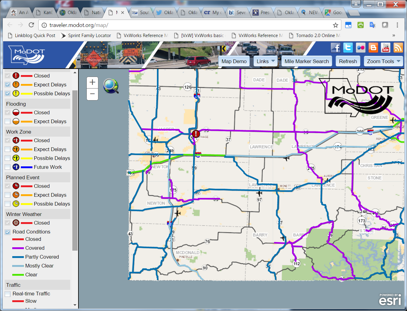
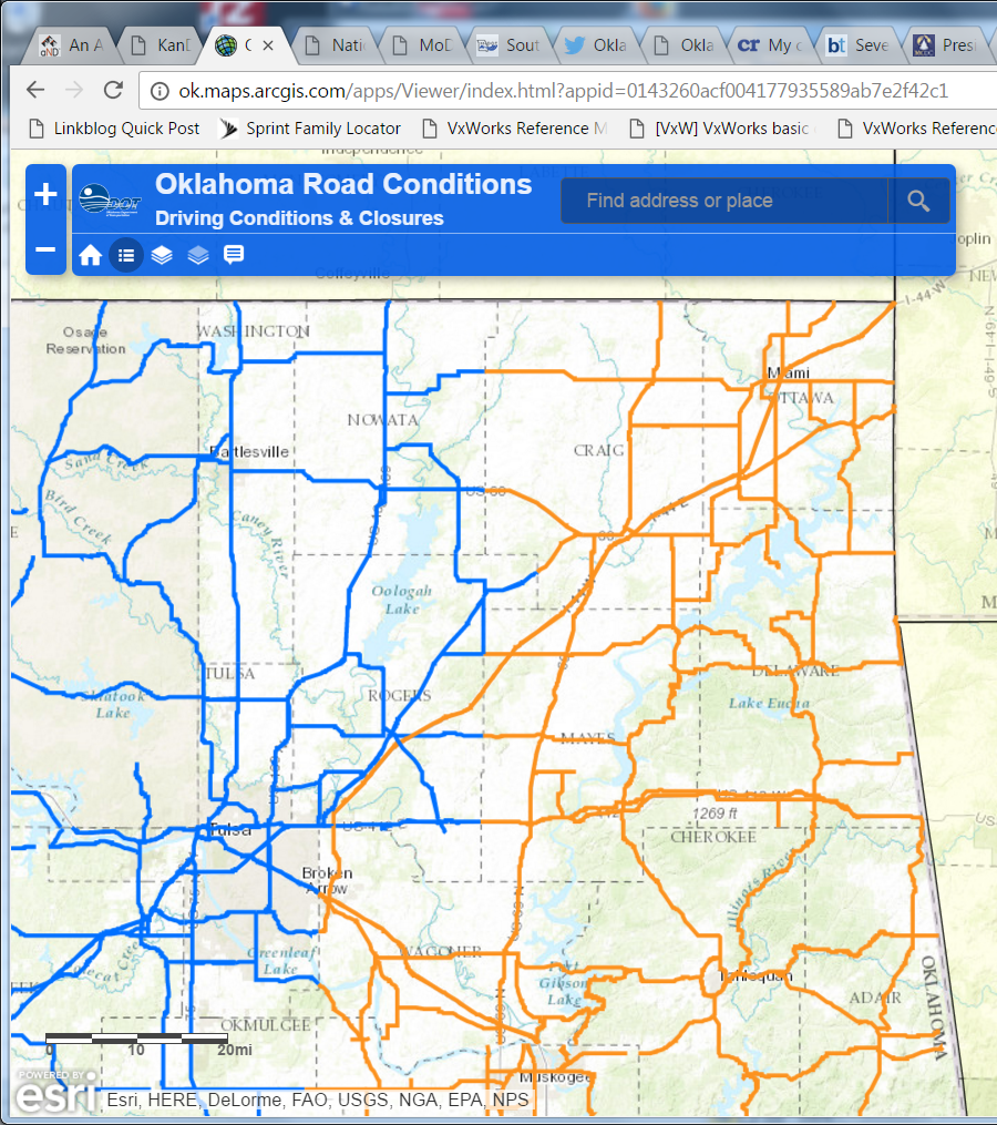
The Oklahoma road conditions map, by contrast, assigned three conditions to the roads -- moderate, severe, closed -- and the same condition was applied to all the roads in a county (with the exception of turnpikes). While Missouri drew a distinction between roads which were known to be clear and roads for which the condition was unknown, Oklahoma's map showed both as unhighlighted. Clicking on the Oklahoma map produced the same boilerplate text for the condition shown -- no location-specific information.
Another thing I did to prepare for the trip was to be sure I was subscribed to Twitter feeds for the Oklahoma Turnpike Authority, Oklahoma Department of Transportation, Missouri Department of Transportation - Southwest, and National Weather Service offices in Tulsa and Springfield, and to turn on mobile notifications -- sending any new tweets to my phone. I had hoped that these agencies would use social media to provide up-to-the-minute news on road conditions and closures. Not so much.
As we drove northeast on the Will Rogers Turnpike, we started to encounter freezing drizzle around the Foyil exit. We had to stop at midway to clear the ice around the edges of the windshield and on the wipers. As we got closer to Big Cabin, we drove past a couple of jack-knifed trucks off the side of the road-- they evidently hit patches of ice on the bridges. (Thanks to the warm temperatures a day earlier, the ice was melting when it hit the road surface -- except on the bridges.) Past the Afton exit, traffic came to a stop.
Ten minutes later, it began moving again, but we soon learned that the Highway Patrol was directing all traffic off of the turnpike. A patrol car blocked the eastbound lanes, and Miami police cruisers were keeping traffic from entering the turnpike in either direction. We rerouted via OK-10 and MO-43, which added about 30 minutes to the trip but had very little traffic.
When did the OTA take to Twitter to notify motorists that the turnpike was closed? Over an hour later, at 4:39 pm. The OTA telephone hotline (1-877-403-7623), supposed to have to have the latest information about turnpike conditions, had not been updated since Friday morning, according to a tweet at 3:28 pm Saturday. It was updated at 5:30 to report that eastbound Will Rogers Turnpike was closed but one lane was open westbound.
Meanwhile, on Twitter, OTA reported at 5:09: "WILL ROGERS TURNPIKE HAS ONE LANE WESTBOUND OPEN AT THIS TIME. EASTBOUND STILL CLOSED."
At 6:00 pm: "WILL ROGERS TURNPIKE EB REMAINS CLOSED DUE TO ICE AND ACCIDENTS. TURNER TURNPIKE IS OPEN IN ALL DIRECTIONS." My question in reply at 6:03 pm -- "What is the plan for salting and sanding Will Rogers Turnpike?" -- went unanswered.
There were no further updates from OTA until they replied to my 8:38 pm tweet noting the lack of hotline updates. Even then, it took another question from me to elicit the information that the closure was only from the Miami exit eastward.
It's a big deal for an interstate highway on a major cross-continent route to be shut down for hours. Twitter, the web, even telephone hotlines offer a quick and inexpensive way to communicate information and keep it current, but only if officials make it their job to provide precise and frequent updates and to respond promptly to questions.
A closing question: How is it that it was safer to drive on the taxpayer-funded side roads than the user-funded toll roads? Shouldn't some of those big toll dollars have gone into salting the turnpike, preventing accidents, and keeping the road open?
ONE MORE THING: OKDOT's 8 p.m. Saturday news release neglects to mention that the Will Rogers Turnpike is closed east of Miami. Did they not know, or did OKDOT not mention it since the turnpike is OTA's responsibility and not OKDOT's? Do they expect travelers to know that there are two different agencies overseeing road conditions?

 A series of encounters led to an opportunity to appear on 612 ABC Brisbane (the Australian Broadcasting Corporation's locally focused station) to talk about the aftermath of the U. S. presidential election.
In late October, I was walking in the Spring Hill neighborhood north of the Brisbane CBD, looking for an affordable alternative to the hotel's unaffordable laundry service. I came across two young men standing on a street corner with a small metal easel sign identifying one of them as Trevor Evans, the Member of Federal Parliament for Brisbane, who was holding a "mobile office" -- making himself available to any of his constituents who might want to bend his ear. I stopped and introduced myself, and we talked about the recent Australian elections, the looming US election, and the excitement I'd witnessed at Prime Minister's Question Time in Canberra the previous week. As the conversation wound down, I asked Mr. Evans if he knew where Brisbanites interested in American politics might gather to watch the returns. He had heard something about a gathering at the Norman Hotel -- thought it was being sponsored by AmCham, the American Chamber of Commerce in Australia -- but he'd be in Canberra on the day.
It wasn't AmCham -- I called, and they knew nothing about it -- but it took me until the day of the event to find out that the sponsor was the Australian American Association. The deadline had passed a week earlier. A phone call went to voice mail, but someone responded to a Facebook message and said come ahead.
As the results started to roll in, a 612 ABC reporter doing a live report from the party wanted comments from a Republican and a Democrat, so I volunteered. The Democrat was a woman who had moved to Australia 20 years or so previously but still voted back in the US. The reporter asked if Trump's apparent win was the last gasp of the white conservative Christian male.
A couple of days later, one of the AAA leaders phoned to say 612 ABC had contacted him in search of a Republican to participate in a studio discussion about the election. I was interested, so he connected me with Sunday morning host Rebecca Levingston, who filled me in on the topics she wanted to discuss. Rebecca told me that her go-to Republican had moved to Perth, and she likes to have guests in studio for these discussions.
Sunday morning I strolled across the Victoria Bridge to the 612 ABC studios in South Bank. Rebecca was at her desk in the bullpen, prepping for the show, and she showed me to the green room, where I was joined a few minutes later by my Democrat counterpart, Peter Axelrod, an aviation attorney originally from New York by way of San Francisco, who had settled in Brisbane about 15 years ago, and his wife, a native Aussie. We had a nice chat, and I was surprised to learn how small the general aviation sector is in Australia, given the vast distances that have to be covered. (This is a country where your doctor may make house calls by plane, and you might talk to your school teacher over the radio.) Regulation holds back the industry.
(Somewhat related: I met some Americans at the hotel who were private pilots and would be touring Australia by air -- this sort of thing. They had to do a checkride on their first day in country to qualify for the trip.)
We were led into the studio by the producer. Peter had come prepared with an article from NPR and some other material, which he had sent to Rebecca ahead of time, and which he let me look over. (It reminded me of the way I used to show up to my weekly slot on KFAQ with pages of background material.) Here's Peter and Rebecca in the studio:

Rebecca was a very gracious host, who asked intelligent questions and was fair and balanced. If she had a political leaning, it wasn't apparent.
The conversation began with Rebecca asking for our reaction to the results. I said that I was relieved that Hillary Clinton would not be president, but apprehensive that Trump will be president. We also discussed prospective appointments (Newt Gingrich and Rudy Giuliani were still possibilities in that first week after the election), presidential power and checks and balances on those powers, filibusters, Obamacare, the electoral college, election turnout, the National Popular Vote proposal, and the need for reform of the nominating process. The final section of the conversation was about the prospects for Trump's promises.
My favorite moment was using a cricket analogy to explain the electoral college and getting a laugh and a complement from Rebecca. The context: South Africa had beaten Australia in the first match of a three-match test series by 177 runs, the latest failure in a long string of Australian losses in international cricket. But if Australia would win the remaining two matches by one run each, they'd win the series, even though their run total would still be 175 less than South Africa's. That's because the series is won by winning a majority of matches, not by getting the highest run total. If the winning criteria were different, you'd use different strategy. (As it happened, Australia lost the second match, too, failing to score as many runs in two innings as South Africa managed in one. After a massive overhaul of the lineup, Australia won the third test handily by seven wickets.)
Here's the whole segment, which runs about 20 minutes.
612 ABC Brisbane was my preferred listening when driving around town or on excursions around southeast Queensland. I appreciated the conversational approach -- where guests had time to develop ideas -- and the variety of serious and silly topics. As I find them online, I hope to share some of the segments that I found particularly interesting.
You can listen to 612 ABC Brisbane on their website or via various apps. ABC Radio has an archive of interviews and conversations on Soundcloud, as does 612 ABC Brisbane.
My other favorite radio station was 1296 4RPH -- Reading for the Print Handicapped. Most of the station's schedule consists of volunteers reading articles from the local and national newspapers and a variety of magazines and books. The articles are often long-form essays, including political analysis, book reviews, and arts criticism. It was real food for thought while driving or taking care of routine tasks. They also carry BBC World Service during the overnight hours and daily broadcasts from two American evangelical broadcasters -- John MacArthur ("Grace to You") and Chuck Swindoll ("Insight for Living"). You can listen to 4RPH via the TuneIn radio app.
Scenes from around Australia illustrate aircraft safety procedures. The brace position demonstration made my wife laugh out loud. Josephine Falls looks like fun. And that's an impressive beard at Lefroy Flats.
BONUS:
How to produce Australian vowels: The long "O" sound amuses me. Women particularly seem to draw it out -- even radio announcers.
In 1908, just seven years after Australia's federation, a young woman named Dorothea Mackellar wrote a tribute to her homeland. The poem, "My Country," is sometimes called by the first line of its second verse, the beginning of the poem proper after a prefatory stanza.
I love a sunburnt country, A land of sweeping plains, Of ragged mountain ranges, Of droughts and flooding rains. I love her far horizons, I love her jewel-sea, Her beauty and her terror - The wide brown land for me!
Here is audio of the poet herself reciting her work, many years later, accompanied by photos of Australia that illustrate "sapphire-misted mountains," "pitiless blue sky," "jewel sea" -- this "wilful, lavish land."
Mackellar was a third-generation Australian, whose grandparents arrived from Scotland in 1839. Her official website describes the sentiment that produced this poem.
The first draft of My Country was written in England when Miss. Mackellar was feeling homesick for Australia. Dorothea Mackellar wanted the verse to express her deep and true love for her country. It was re-written several times before a satisfactory completion.She resented the tendency of acquaintances in her youth to discredit Australia, and to refer to England as 'Home'. As a young girl Dorothea was clearly aware of the variety and beauty presented by the Australian landscape. The majority of her poetry has taken its imagery from her love of the natural Australian scenery. The original title for "My Country" was "Core of My Heart", and was the title used when the poem was first published in 1908, in the London Spectator Magazine.
Here is a choral setting of the poem:
A bit of silliness in the form of a YouTube playlist:
Josh Hawkins and Rhys Keir explain how to speak Australian and, in a second video, how Australians abbreviate names. The third video features Hawkins with an adorable six-year-old girl who translates his phrases into formal English.
Hawkins is the minister to young adults for St. Paul's Castle Hill Church in Sydney.
Later in the playlist, I've got some videos from the Film Australia Collection -- short subjects produced in the 1950s and 1960s aimed at attracting immigrants -- and a historical documentary on the evolution of Brisbane's main shopping street over 170 years of history.
The Tulsa Buffaloes Australian Rules Football team will play Des Moines this Saturday, September 10, 2016, at 2 p.m. at Veterans Park, 21st & Boulder Ave.
The word "football" in Australia can have five different meanings, each of which corresponds to a different professionally-played sport:
1. Gridiron football -- what Americans usually mean when we say "football," with yard lines, helmets, pads, downs, and forward passing. The National Gridiron League was set to launch this October with eight teams along the east coast, but delays (visas for players and coaches, according to rumor) have forced the first games to October 2017. Every state but Tasmania has a gridiron league; Queensland has 11 clubs, each of which hosts a men senior team (19 and up), and many host teams for women, teenage boys (14-18), and pre-teen boys (10-13). In 2014, five state-wide teams participated in a round-robin competition called the Australian Gridiron League. An Australian national team participates in the International Federation of American Football along with the US, Mexico, France, Brazil, Japan, and South Korea.
2. Rugby union -- the original form of rugby, played 15 to a side. Originally an amateur sport, teams in five major Australian cities participate in a professional Super Rugby league that includes teams in New Zealand, Japan, Argentina, and South Africa. There are leagues and clubs at state and regional levels.
3. Rugby league -- the schismatic form of rugby, but the most followed professional form in Australia, with 13 to a side and more continuous flow of play. This is the pro sport that gets the most attention in the eastern states of Queensland and New South Wales, reflected in the annual State of Origin three-match series that pits representative teams from the two states against each other. The rule books of Rugby League and Rugby Union are referred to as "codes," and the term has been generalized to refer to the different forms of football, including those with no connection to rugby.
4. Soccer: Highest level of participation of any sport in the country, but not as popular as Rugby League as a spectator sport. Highest league is the A-League, with 10 teams (including one in New Zealand). The indoor variant is known as futsal.
And finally:
5. Australian rules football: If you watched ESPN in the early days, before the network was part of the Disney family, before the network had won the rights to air major league US sports, you probably witnessed the spectacle of 18-a-side "football" played on an oval and officials in fedoras and lab coats signalling goals by pointing their fingers and waving flags. Four poles stand at each end of the oval or "paddock," which can range from 135 to 185 meters long. A ball kicked between the two tall posts at the center is a goal worth six points; a ball that goes between one of the shorter outside posts and one of the tall center posts is a "behind" worth one point.
Aussie football had its origins in Melbourne, and the state of Victoria remains the heart of its popularity, but the top Australian Football League has teams in major cities across the nation. Four of the AFL clubs in Queensland and New South Wales have reserve squads that play alongside six non-affiliated teams in the second-tier North East Australian Football League. One step further down (AA, in baseball terms), statewide leagues like AFL Queensland offer clubs at various levels of play, and the clubs typically have several squads, such as seniors, reserves, juniors, and women; often all the squads from two clubs will play each other in a series of matches on the same day.
About a month ago, I took the CityCat (a catamaran ferry that runs between the Brisbane ocean liner port at Hamilton and the University of Queensland campus several miles upstream) to see an Aussie rules match in person. The match was between the reserves of the University of Queensland Red Lions and the Western Magpies. I arrived in time to see the last two 20-minute quarters. No admission was charged. There were a couple of three-row bleachers, but most of the few dozen spectators sat on grassy berms around the oval, seeking shade where possible on a warm midwinter day. As the game rolled on, pink-shirted water carriers would circulate among the players who were away from the ball. As large as the oval was, it was tough to get a clear view of the action on the other side, and I could understand why field-level seats at an NEAFL match were less expensive than higher level seats.
A concrete pavilion at one end of the field had locker rooms, restrooms for spectators, and a concession stand with a grill where sausages, burgers, and onions were being cooked by supporters of the home club. The burgers were served on a sesame bun, but the sausages were served with grilled onions in a diagonally-folded piece of white bread. Soft drinks were available, but you could also get a XXXX Gold (the local beer) or a can of Bundaberg rum and cola. (Fosters is not Australian for beer, at least in Queensland. I don't think I saw a Fosters for sale the entire trip.)
True to their nicknames, the Magpies were much more aggressive and noisy than the UQ students, calling out to each other and heckling the UQ players when they took free kicks. The Magpies reserves beat UQ handily, 19 goals, 11 behinds for 125 points to 5 goals and 12 behinds for 42 points. I stayed around for the first few minutes of the next match, between the seniors, the top players of each club, which started out more competitively, then met up with some friends for a tour of the city.
Tulsa has an Australian rules football team, the Tulsa Buffaloes, who play their home matches at Veterans' Park.
Now the Lord had said unto Abram, Get thee out of thy country, and from thy kindred, and from thy father's house, unto a land that I will shew thee: And I will make of thee a great nation, and I will bless thee, and make thy name great; and thou shalt be a blessing: And I will bless them that bless thee, and curse him that curseth thee: and in thee shall all families of the earth be blessed. So Abram departed, as the Lord had spoken unto him; and Lot went with him: and Abram was seventy and five years old when he departed out of Haran. And Abram took Sarai his wife, and Lot his brother's son, and all their substance that they had gathered, and the souls that they had gotten in Haran; and they went forth to go into the land of Canaan; and into the land of Canaan they came.
Then spake Joshua to the LORD in the day when the LORD delivered up the Amorites before the children of Israel, and he said in the sight of Israel, Sun, stand thou still upon Gibeon; and thou, Moon, in the valley of Ajalon. And the sun stood still, and the moon stayed, until the people had avenged themselves upon their enemies. Is not this written in the book of Jasher? So the sun stood still in the midst of heaven, and hasted not to go down about a whole day. And there was no day like that before it or after it, that the LORD hearkened unto the voice of a man: for the LORD fought for Israel.
And it came to pass, as Peter passed throughout all quarters, he came down also to the saints which dwelt at Lydda. And there he found a certain man named Aeneas, which had kept his bed eight years, and was sick of the palsy. And Peter said unto him, Aeneas, Jesus Christ maketh thee whole: arise, and make thy bed. And he arose immediately.
-- Acts 9:32-34
Lod (לוד): Population: 71,060. Election results: Likud 32.77%, Joint Arab List 16.15%, Israel Our Home 10.30%. By group: Nationalist parties 62%, Arab parties 17%, Leftist parties 13%, religious parties 7%.
Beersheba (בְּ×ֵר שֶ×בַע): Population: 197,270. Election results: Likud 37.69%, Zionist Camp 12.24%, Israel Our Home 12.06%. By group: Nationalist parties 70%, Leftist parties 21%, religious parties 7%, Arab parties 1%.
It doesn't seem to matter how early we start to plan and pack, we can't seem to avoid the last-minute scramble before a trip. The morning of our March 7 departure included a 2 a.m. run to Walgreens for a few items, a visit to the ATM and the post office (to mail some get-well cards), and an unsuccessful attempt at getting the accumulated grit and grime of winter washed off of the car. (March 6 was the first really nice day in weeks, and it seemed like every car wash ran out of soap that day.) I got about a one-hour nap before I got up, got myself ready, then got everyone else up. My mom and dad came by, bringing Whataburger sausage biscuits and coffee and both of their vehicles (the Avalon and the Santamobile) to help get the five of us and all of our stuff to the airport. We weighed bags and rearranged and jettisoned. I shooed everyone out the door and ran through my checklist for closing up the house.
By now, the loyal readers that have bothered to hang around will not be surprised by long gaps between blog entries. Work and family obligations have been preempting time and energy to write for publication here or anywhere
The most recent silence was about family, but much more joy than obligation. The whole family spent the last two weeks on a physically and intellectually demanding study tour of Israel, under the auspices of Augustine Christian Academy and the Jerusalem Cornerstone Foundation. The itinerary took us from Dan even unto Beersheba, from the Mediterranean Sea to the Jordan River, from the lowest point on Earth to the foothills of still snowy Mount Hermon. We saw the country at its greenest, with even the desert in bloom, at the tail end of a wet winter and spring, before the withering heat of summer sets in.
The people and places of the Bible were certainly at the center of the tour, but we covered nearly the entire span of recorded human history, from city gates that Abraham likely passed through over 4000 years ago to the present day. I don't know of any spot on the planet quite like Israel, where nearly every great world empire has left its mark -- Egypt, Assyria, Babylon, Persia, Greece, Rome, Byzantium, Mecca, the Umayyids, the Abbasids, the Crusaders, the Mamluks, the Ottomans, Napoleon, the British. (That's us below, in front of a Roman aqueduct near the Mediterranean Sea at Caesarea Maritima.)
Over the course of the tour, I managed to fill a small Moleskine notebook with tiny writing, and the five of us took tens of thousands of photos. Although I'm back at work and back to the old grind, I want to spend some time sorting through the notes and images and memories while they're still fresh. So don't expect to see political posts any time soon.
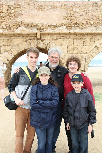
The National Trust for Historic Preservation's Preservation Blog has put its spotlight on the efforts of the City of Independence, Kansas, and the Friends of Riverside Park and Zoo (FORPAZ) to preserve the park's historic playground equipment while meeting modern safety requirements:
When Riverside Park's insurance company told park staff that they needed to remove two playground slides dating from the early 1900s for safety reasons, Barbara Beurskens, director of the Independence, Kan. park, knew that she and her team had to find a solution that would keep the metal playscapes in place."These are so important to the community," says park staffer Rachel Lyon of the tall slides manufactured by the now-defunct FUN-FUL company.
The solution involved installing tons of rubber mulch under the slides, improving guardrails, and undergirding ladders to prevent slip-throughs.
So often the difference between demolition and preservation is affection. City officials confronted with an insurance company's warning often respond with a helpless shrug, followed by an order to send the bulldozers. That's easier to do if you have no emotional connection to what's about to be torn down.
But the city officials here understood that generations of former children from Independence and the region have rich memories tied to these slides and see-saws, memories of overcoming their fears, memories of games of imagination.
I note from a websearch that Park Director Beurskens has worked for the City of Independence in one capacity or another for over 30 years -- clearly, she's been around long enough to understand that "This Place Matters" (to borrow an NTHP slogan). Perhaps she had children of her own who grew up playing on the big slides.
NTHP's Katherine Flynn has included (with my permission) some of my photos of Riverside Park's historic playground equipment from 2007. After an earlier visit in 2003, I described the equipment and wrote about my amazement that the playground equipment I remembered from my childhood visits was still there and in use, and I alluded to the liability concerns that have caused classic equipment to vanish from playgrounds and parks across the country.
A spinning circle -- the kind with the raised elongated bumps at right angles for traction, and bars radiating and rising from the center, then forking out and connecting to the edge. [My son] Joe was riding it, having me spin him faster and faster. As he was spinning, and as I was pondering whether, out of appreciation for the City of Independence having the guts to keep this classic play equipment available, I would refrain from filing suit if one of my kids were injured -- as if he could read my mind, Joe launched himself off the circle. His foot was caught by one of the handholds and it seemed he might be dragged around, but the circle stopped quickly. Joe was fine, grinning. He got up, brushed off the sand (that's what they use around all the play equipment -- not hard, splintery wood chips, but nice soft sand). "I intended to do that. I thought it would be cool to jump off!"
We passed through Independence in May, and we spent a couple of hours there walking through part of the zoo, riding the train and the carousel, and playing on the playground. It was a gray and damp day, so the slides didn't move very fast. Here are a few pictures which show some of the safety improvements:
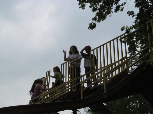
MORE:
Visiting Riverside Park: The park is open 6 a.m. to midnight daily. The train, carousel, and mini-golf are open weekends from 1 p.m. to 8:30 p.m. and weekdays from 5:30 p.m. to 8:30 p.m. between Memorial Day and Labor Day, and weekends from 1:30 to 5:30 p.m. in spring and early fall. (October 20 is the last day in 2013 for the rides and mini-golf.) The zoo is open 9 a.m. to 7 p.m., April through October, then 9 a.m. to 5 p.m., November through March.
City of Independence Riverside Park and Ralph Mitchell Zoo webpage
Riverside Park and Ralph Mitchell Zoo on Facebook
Friends of Riverside Park and Zoo (FORPAZ) website
Friends of Riverside Park and Zoo (FORPAZ) on Facebook
BONUS: Playground swings sound like trumpeting elephants:
Time to tame the tabs. Here are a few articles worth your notice:
Natasha Ball has compiled This Land's list of 50 Best Spring Break Things to Do in Oklahoma. For all my years and all my travels, I see plenty of items that I have yet to accomplish and many more that I have yet to share with my kids.
 Something not on her list because it's not in Oklahoma, but worth a visit, and only about 2 hours east of Tulsa: Crystal Bridges Museum of American Art in Bentonville, Arkansas. Beautiful setting in a wooded ravine. Architecture that looks like the lair of a Bond villain. And for the next two months, through May 27, 2013, a wonderful exhibit of the art of Norman Rockwell -- full-sized paintings, many of them covers he did for the Saturday Evening Post.
General admission to the museum is free, sponsored by Walmart. Admission to the Rockwell exhibit is $12 for adults; children 18 and under and museum members are admitted at no charge. There's an audio tour of the Rockwell exhibit at no extra charge -- well worth taking. It's an iPod Touch; you key in the number of the painting you're viewing for narration, sometimes including Norman Rockwell himself, a member of his family, or one of the models for the painting. We were there about a week ago and really enjoyed it. We needed two hours just to see the Rockwell exhibit.
Promoting your hometown for tourism is a tricky business. It may be a nice place to live, but why would anyone want to visit there? The Oklahoma-based blog Small Biz Survival has notes from a talk by Roger Brooks of Destination Development International on how to market a community, listing the common pitfalls of small-town marketing, most of which apply to places like Tulsa, too:
The first fact he mentioned is about how we search when we're looking for somewhere to go. We search on activity first, then location second. So we'll search "mountain biking western Oklahoma" or "sailing southern Ontario." Brooks' examples showed people searching on an activity and then a town name."Have you ever gone anywhere because they 'have something for everyone' or they are the 'gateway to' someplace else?" Brooks asked.
Brooks urged asking these questions:
- What do you have that the people you are hoping to attract can't get or do closer to home?
- What makes you worth a special trip?
- What sets you apart from everyone else?
It's long been a frustration to me that the tourist materials produced for Tulsa by a branch of the Tulsa Regional Chamber focus on Tulsa's sophistication and the kind of amenities you'd expect to find in any large American city. These brochures and booklets might reassure people who are thinking about relocating to Tulsa, but they won't attract visitors from around the country or around the world. On the other hand, Tulsa's truly unique features and history get downplayed. Brooks addresses the psychology that produces a generic and ineffective marketing message, and includes a list of phrases that should be banned from your tourism brochure, including so much to do, center of it all, best kept secret, outdoor recreation, and playground.
Streetsblog looks at why enclosed malls are dying even in small cities, like Effingham, Illinois.
Steve Lackmeyer at The Oklahoman covers what looks like defiance from Oklahoma City's public works department over the implementation of Project 180, the program to make downtown streets safer and easier to navigate for pedestrians, cyclists, and drivers alike.
At the Washington Free Beacon, there's a review of Detroit: An American Autopsy, a combination of investigative reporting and personal narrative on the decline and fall of a once-great metropolis. "An American Autopsy often reads like an old detective novel. There are mustachioed homicide detectives, hit men, con men, grifts and drugs, greed, and corruption."
Next American City reports on a Brookings Institution study of Amtrak ridership: Shorter trips (under 400 miles) have more riders and make more money than long-distance runs.
Notes hither and thither:
If you're a fan of beautiful cartoon art, you should make at least a weekly visit to Whirled of Kelly, which features the art work of Walt Kelly, most famous for the comic strip Pogo. Blogger Thomas Haller Buchanan has been running a series of Sunday strips from 1952, scanned in color from the newspaper. The sequence involves Albert telling a fractured fairy tale called Handle and Gristle. The January 2013 archive also includes scans of Story Book Records from 1946: The discs were illustrated by Walt Kelly, and he's the reader on the recordings.
Nice Deb's Sunday tradition is a hymn, and this week it's a metrical setting of Psalm 23: The King of Love My Shepherd Is.
Maggie's Notebook has a bizarre story: The State of Delaware is stripping its county sheriff's departments (all three of them) of the power to make arrests and enforce the law. This despite a constitutional provision that says that "the Sheriffs shall be conservators of the peace within the counties respectively in which they reside." Only one of the three sheriffs, from Sussex County, is objecting to the change.
Route 66 News reports on a new Route 66 Dining and Lodging Guide, handy for finding comfortable, historic, and locally owned along Route 66. (I love Jack Rittenhouse's guidebook, but it's old enough to collect Social Security, and Michael Wallis's book is old enough to drink.)
 This is the final week to see a piece of George Washington's Mount Vernon right here in Tulsa. The traveling exhibition "Discover the Real George Washington: New Views from Mount Vernon" at Tulsa's Gilcrease Museum. The exhibition's final day is September 23, 2012.
The exhibit goes beyond the familiar basic facts of Washington as our 1st President and the Father of Our Country to help you get to know Washington the surveyor, young officer, churchman, and agricultural innovator, among many other roles.
Earlier this summer my family visited Mount Vernon and saw the new Donald W. Reynolds Educational Center there. The exhibit you will see here in Tulsa is a near-duplicate of the permanent exhibit in Mount Vernon, including three life-size figures depicting Washington at different ages -- as a young surveyor, as Commander-in-Chief of the Continental Army, and as President of the United States. The figures were developed using forensic analysis of a life mask, paintings, clothing, and other artifacts. Short videos from the History Channel accompany interactive exhibits.
My youngest son said he liked the exhibit at Gilcrease better, because you could look in through the side of the Fort Necessity diorama to see the battle from the perspective of those hiding in the forest.
One thing we saw at Gilcrease that we did not see at Mount Vernon: George Washington's dentures and the story of how they were made.
Unless you travel to Mount Vernon, you won't be able to see George Washington's repository for dung, see the "rustication" used to make the wooden mansion appear to be made of stone, or admire the vistas from the back of the mansion to the Potomac River, but you'll be able to learn about these things right here in Tulsa at Gilcrease Museum through Sunday or at the exhibit's companion website, Discover the Real George Washington, where you can explore an interactive timeline and see the same History Channel videos on display in the exhibit.
Gilcrease Museum is open 10 a.m. to 5 p.m., Tuesday through Sunday. Admission is $8 for adults, children 18 and under are free, and there are discounts for seniors, groups, and active duty military. Gilcrease Museum is owned by the City of Tulsa and curated by the University of Tulsa.
My wife wanted more blueberries.
She and the two younger kids picked an astonishing amount (18 gallons?) a few weeks ago at Thunderbird Berry Farm east of Broken Arrow. Nevertheless there didn't seem to be enough to cover pie baking, freezing for later, and random noshing. She wanted more, if we could get them.
Saturday she thought perhaps we could go and pick some more. Nope: Thunderbird's Facebook page said they ended the season June 30. Getting too hot for the berries. Owasso Tree Farm's website said they were done, too, not just blueberries but blackberries, too. The early hot weather had ripened everything earlier than normal.
So Saturday morning the six-year-old and I headed to Cherry Street for the Farmer's Market. We kept our eyes out for blueberries but found none.
I have mixed feelings about farmer's markets. I love the concept: A weekly community gathering, farmers bringing fresh produce straight to the consumer, no middleman to boost the price to the consumer and lower the price to the farmer, supporting our community's ability to feed itself in the event of a disruption to national and international food distribution networks.
In practice, I find it uncomfortable and expensive. I never have a clear picture of what I need, so I either underbuy or overbuy. I find myself tempted to make aspirational purchases -- buying food without a realistic idea of when we'll cook and eat it. It's awkward to look at produce at one booth, under the watchful eye of the farmer, only to excuse myself to see if the tomatoes are better or cheaper at any of the other booths. I rarely know what the price of the item is at the supermarket, and even if I did, the farmers tend to use a different standard to price each item than the supermarket does. Reasor's prices peaches by the piece, one farmer prices them by dry measure, another prices by the pound. So I leave feeling glad that I helped support a local farmer (particularly if it's someone I know), glad that I bought some fresh food, but frustrated with myself for not being a good steward of the family food budget.
Lomah Dairy had a sign at its booth that explained that their cows have names and are treated with love and respect. It brought to mind that Portlandia sketch where a hipster couple at a restaurant grills the waitress about the living conditions of the chicken they were about to eat for dinner. ("His name was Colin. Here are his papers.") Unsatisfied with the waitress's claims, they go to the chicken farm to investigate for themselves.
One booth sold us a bag of pickle cucumbers for $4 and 6 ears of corn for $5. (The pickle cucumbers were the six-year-old's idea.) The ears were a bit scrawny (already picked over toward the end of the market, I expect), so the farmer threw in a couple more on the house.
I stopped at the Bootstrap Farm booth because I recognized one of the farmers as a friend who is a philosopher and erstwhile barista. We were given a sample of golden, sweet cherry tomatoes, and we bought a quart container of them, plus a few pounds of vine-ripened, regular-sized tomatoes -- $11. (I had one of the big tomatoes that night with a little bit of salt -- wonderful!) Then a stop by the Council Creek Farm pickup, its bed loaded with fresh cantaloupe and watermelon. We bought one big watermelon ($6) and two canteloupe (@ $4) -- $14. I struggled up the hill to the car cradling the melon in the crook of my arm, carrying a plastic shopping bag with the corn, cucumbers, and tomatoes by the handle, and carrying a partly torn plastic bag with a cantaloupe. The six-year-old managed to carry the other cantaloupe in his arms.
We dropped off the goods, then headed back down the hill for a cup of coffee (for me) and a cup of fruit (for him, although I ate the pineapple, kiwi, and orange bits he didn't want).
Next stop: Hardscape Materials in Bixby. We've got a small pond, bequeathed to us by the previous owners, and I've tried to keep it in shape, but because of the big freeze of 2011 and a 15-month stretch when work had me out of town half the time, things got out of hand. Tall flowering plants, joined by a thick mat of roots, had completely taken over the pond. (We were told they were water hyacinth, but they aren't.) I cleaned all of them out, leaving the water lilies, but in the clean out process I apparently made a couple of small tears in the liner.
So we went to Hardscape Materials, which has an entire building devoted to pond equipment and supplies and several large demonstration ponds with waterfalls, fountains, rocks, and gigantic koi. Hardscape has developed many of the pond products they sell.
They had the patch kit we needed, and after we bought it, the six-year-old led me around the grounds for a while. (There are few more interesting ways to spend time than to follow the whims of a six-year-old.) Hardscape has acres of stone, rock, and gravel of all types. They even sell basalt columns. They come from naturally hexagonal rock formations, the most famous of which is Giant's Causeway in Northern Ireland.
Back in the car and south on US 64. Next stop was Carmichael's produce stand, on the west side of the road just south of the river. They had plenty of Bixby corn, much healthier-looking than what we bought on Cherry Street -- a dozen ears for $6, cheaper than $7.50 for the same amount at the supermarket. Cucumbers were two for a dollar, sweet potatoes were 89 cents a pound (same price as the supermarket), so we bought some of those.
And they had blueberries from Nacogdoches, Texas -- $32 for a flat of 12 pints. That was much cheaper than the supermarket, where we would have paid about $48 for the same amount. Via text message, I was told to buy two flats.
They had peaches, too, but I intended to buy some peaches straight from the orchard in Porter, so we headed south again, but not before a quick drive around downtown Bixby. We noticed the removal of an ugly facade from a historic retail building in progress, a steeple for sale, and an interesting two-story gas station that now belongs to the local historical society.
South and east again along US 64 through Leonard and Stone Bluff, which reminded the six-year-old of Route 66, which led to questions about when towns were bypassed by highways and why the interstate highway system was built, followed by answers about pre-interstate bypasses and Eisenhower's post-World War I convoy across America and his experience with autobahns in Germany and how some bypasses (like Tulsa's Skelly Bypass) don't bypass anything any more.
Downtown Haskell has lovely new streetscaping, some interesting buildings with potential, and a couple of blocks where most of the buildings are gone, the result of a fires some years ago. (The Google street view imagery from February 2008 shows how much is now missing.) We stopped at Family Style Barbecue, in one of the old buildings, for lunch. The ribs were pretty good, a bit fattier than I like, but good flavor and no need for sauce. The beans had a nice smoky flavor. I tried a bit of their barbecue sauce but didn't care for it. The six-year-old enjoyed his ham sandwich, but not as much as he enjoyed the funny animal-video show on the TV in the corner.
After lunch we walked around a bit, noticing a sign ("HOME AND AUTO STORE") that had belonged to the OTASCO that once had been there, across the street from a building bearing the name ADELMAN (which, if memory serves, was the name of the family that built the Delman Theater at 15th and Lewis -- they dropped the initial A), an exposed native stone wall, a hexagonal tile floor (the only remnant of Broadway Cleaners), a pig statue in front of a butcher's shop and a mid-century modern facade on a defunct bank building. The six-year-old noted the irony of the painting on Family Style Barbecue's window: three walking pigs -- dad, mom, and son -- carrying balloons, one of which read "LET'S EAT!" "They shouldn't go in there. They'll be butchered!" he said with a grin.
East on 104 across the Arkansas River at Choska, then on to 231st Street, a gravel road between sod farms. We'd have probably been better off to go a couple of miles north, then east and back south, but I was following Google's directions. The six-year-old was grateful to get back on a paved road after two or three miles.
Livesay Orchards had lots and lots of fresh peaches, at least three different varieties, and a lady at a booth offered samples on toothpicks of each. They had a special on Scarlet Prince -- a half bushel for $18 (other varieties were $27 for a half bushel). They also grow apples. We drove past the orchards heading east, north on the first paved road into Porter proper, where the east-west streets are named for peach varieties. Porter is a town that could use some serious TLC. The town's famed Porter Peach Festival is July 19 - 21, 2012. This year they'll have carnival rides, mud races, a 5k run, and a car show, in addition to the peaches.
Home the easy way, on 51, and then the hard part -- finding some place to put 20 ears of corn, a big bag of cucumbers, a half-bushel of peaches, five pounds of sweet potatoes, two flats of blueberries, two cantaloupes, and a watermelon. I baked all the sweet potatoes, and we had watermelon, peaches, and tomatoes with a little bit of leftover ham for dinner that night.
My wife gently reminded me that the fresh produce is perishable, is best when you buy it, and you want to use it before it goes bad. So we are going to be gorging ourselves on fruit and vegetables for a week or so.
P. S. Anyone have a good pickle recipe? I'm thinking half-sour or maybe bread-and-butter.
We're getting rid of clothes we don't need and came across a couple of bright teal windbreakers from the 1990 International Science and Engineering Fair, which was held in Tulsa that year. My wife and I, then newlyweds, volunteered for the fair, marshalling buses and giving directions to visitors.

I guess we took the windbreakers with us to Europe later that year, because in the pocket of the smaller jacket was a little wrapper, likely from a mint:
MÖVENPICK
Heidiland
Autobahnrestaurant N13
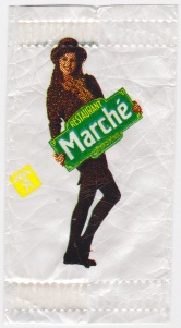 On the back, a young female model holds something that looks like a Paris street sign, reading:
RESTAURANT
Marche
MÖVENPICK
The Mövenpick Marché Heidiland is a roadside restaurant in Canton Graubünden, in eastern Switzerland. It's part of a chain, but more than just a fast-food place -- more like the Stuckey's and Howard Johnson's you used to see along Oklahoma's turnpikes, but much bigger and nicer. You'll still find this sort of thing along the some east coast turnpikes and British motorways -- restaurant or food court, convenience store, tourism info -- some of them approach the size of small malls.
But I've never been to one in the US or UK with a goat enclosure.
Marché Heidiland, on the highway A13, is one of the most well-known rest stops in all of Switzerland. The "Heidi and Geissenpeter Game" is waiting for you as soon as you walk in the front door. Two large game rooms provide an exciting experience for all kids. There is also an outdoor playground and a goat enclosure close to the entrance.
We would have come across this place on the way between picking up a rental car in Vaduz, Liechtenstein, and our stop for the night in Chur, Switzerland.
Our September 1990 vacation, facilitated by my wife's employment with American Airlines, started in Frankfurt and took us to Rothenburg ob der Tauber, Mittenwald, Garmisch-Partenkirchen, and Munich in Germany, Prague in newly freed Czechoslovakia, Vienna, Melk, and Salzburg in Austria, Liechtenstein, Chur, Glarus, Lucerne, Rüschlikon, and Zurich in Switzerland, whence we flew home. We had a Eurail / Hertz car/train package deal, used the car in Bavaria, took the train through Czechoslovakia and Austria (including a brief ride on a boat on the Danube), then picked up a car in Vaduz for the last few days of the trip.
I remember being disappointed that you couldn't find a cheap lunch in Vaduz, as you could in Austria, Bavaria, and Prague. So we likely stopped here for a meal.
I don't recall whether it was cheap then, but it certainly isn't cheap today. The website touts fresh baked goods and abundant buffets. The evening buffet (7 pm to 10:30 pm) runs $25, not including beverages. The lunch special -- dish, drink, and dessert -- is about $18, and the Sunday brunch buffet is about $27. There are size discounts: Under 110 cm is free, under 140 cm is half price. The bargain breakfast -- croissant, bread roll, butter, jam, and coffee -- is only $9. (The US dollar and the Swiss Franc are right about at par at the moment. When we visited, a dollar was worth 1.30 Swiss Francs.)
In addition to the goat enclosure, the Marché Heidiland has an outdoor playground, an indoor play area, a smokers' room, a conference room, and free WiFi.
The baby facilities are impressive: A microwave oven, bottle warmer, and hot water kettle for use in preparing your baby's food, built-in changing tables (not just pulldown tables in the handicapped toilet stall), and special strollers that give you a place to put your tray of food and your child's tray as you navigate the buffet.
MORE: Bill Clinton stopped here on his way to Davos a couple of years ago.
MORE reminiscing: Older readers will recall the midway rest stop on the Turner Turnpike, with a pedestrian bridge connecting eastbound and westbound rest areas. The eastbound area had a Howard Johnson's restaurant, a souvenir shop, a Phillips 66 service station, and a tourism display. One thing you couldn't get on the eastbound side was a bottle or can of pop. If you wanted anything other than HoJo Cola, you had to walk over the turnpike to the vending machines at the Phillips station on the westbound side.
MORE stuff that fell out in the dryer (should have checked the pockets more carefully): A chestnut and (found in the lint trap) a ticket labeled "RVO" dated September 26, 1990, at 16:00, for two people. RVO is a regional transportation company in the Bavarian Alps, so perhaps this was a ticket for our day train trip from Salzburg to Berchtesgaden with another American couple.

Photo of Sid's Cafe, Holmfirth, Yorkshire, by Flickr user nechbi, Creative Commons Attribution 2.0 Generic license (CC BY 2.0)
One of my favorite TV series is the long-running BBC sitcom "Last of the Summer Wine," about the exploits of three old men with plenty of time to get into mischief in a picturesque Yorkshire village and the surrounding hills. The program ran for 37 years and continues in reruns around the world. (Locally, OETA runs two back-to-back episodes nightly Monday through Thursday at 11 pm.)
The people of Holmfirth, the principal filming location for the series, has done an admirable job of turning fan interest into tourist dollars without ruining what made the town an attractive filming location and place to visit.
One frequently seen location, Nora Batty's cottage, is available as a self-catering accommodation sleeping six, with weekly rates ranging from £305 in winter and late fall to £661 in peak summer season. (That's about $500 to $1100 at current exchange rates.)
Down the steps, just where it should be, is Compo's tatty flat, now an exhibition with props from the show, and next door to that, the Wrinkled Stocking Tea Room, where you can have a traditional Yorkshire breakfast (bacon, egg, sausage, tomato, beans, mushrooms, and black pudding) or afternoon tea. There's a gift shop, too.
The Automobile Association describes a five-mile walking tour around Holmfirth that will take you up hill and down dale, over stiles and through fields and woods.
You can have lunch at Sid's Cafe, too, and just outside catch a bus tour of Summer Wine filming locations.
Photo of Holmfirth, Yorkshire, by Flickr user Tim Green aka atoach, Creative Commons Attribution 2.0 Generic license (CC BY 2.0)
 Amongst the cache of educational short-subject films available at the Internet Archive, I came across this documentary of a narrow-gauge railway in northwestern Wales, the Talyllyn Railway, being kept alive by preservationists. The documentary was released in 1965, but was filmed in the early 1950s.
The railway opened in 1866 mainly for the purpose of hauling slate seven miles from the mines to the sea, but also carrying passengers. The mines having closed, the railway was shut down in October 1950, but reopened by volunteers the following May 1951 and has been continuously operated by volunteers for the 60 years since.
I had read about the Talyllyn Railway in my then-little boy's single-volume collection of Thomas the Tank Engine books (aka The Railway Series by the Rev. W. Awdry). When work brought me to Shropshire in May 1999, I took the opportunity for a day in north Wales, including a ride on the Talyllyn, from Dolgoch Falls to the top of the line at Nant Gwernol and back, followed by a drive to the seaside at Tywyn and the museum at the end of the line.
The melancholy harmonica of the documentary's theme brings to mind the theme of the long-running Yorkshire sitcom Last of the Summer Wine.
MORE: The filmmaker, Carson "Kit" Davidson, has an interesting biography. He's still around, living near Rutland, Vermont, and editing submissions to medical journals.
Tabitha Hale, FreedomWorks frequent-flying new media director, was confronted on Tuesday with an extremely unpleasant screening experience at at Houston's Bush Airport, the site of last November's "Don't Touch My Junk" rebellion.

Then she got to my waist band. I had on black tights under my dress, which I'm certain is not uncommon. She asked me to lift my dress so she could check the waistband of my tights.
I felt my stomach drop. I said "I'm not lifting my dress for you. No way." She was obviously irritated with me now and said that she would take me to the private screening area if I would like.
I said "No, absolutely not. If you can't do this in front of everyone, you should not be doing this to me."
She then called a manager over. The manager approached me and explained what they were going to do and that if I failed to comply, they would escort me from the airport. I told her I saw no reason that they should have to lift my dress to clear me to get on a plane. I would have, however, allowed them to escort me out of the airport before they got me to lift my skirt and stick their hands down my tights. I was bracing myself to spend another night in Texas.

They figured a way to check her waistband without lifting her skirt, but the resulting pat down "was so vigorous I had to readjust my clothes when she was finished."
Here's the thing. If anyone else had done this to me, I would have decked them and likely filed charges. The fact that the person has on a TSA uniform is supposed to make it okay? It isn't. Why should any person be subjected to this to get on an airplane? We're supposed to subject ourselves to inappropriate touch for teh sake of "safety"?I fly for my job. I travel frequently. I take trains when I can, but most of the time it's just not practical. The fact that I have to endure this type of force just to do my job is horrifying. I don't really have another option. Most of us who travel for work don't have a choice.
I have to get on a plane to Denver tomorrow, and am honestly dreading the idea of going through the airport. TSA needs to go. This has gone so far beyond a security precaution, and is a clear violation of the rights of travelers. Showing my business to an airport full of people is not in the interests of safety. It is wrong.
Too bad for Tabitha that Republican legislative leaders in Texas blocked freshman State Rep. David Simpson's bill forbidding government employees from touching a person's private areas without probable cause. The bill passed both houses by wide margins, but fell short of passage on a procedural issue. In a personal privilege speech on the final day of the special session, Simpson explained the importance of the bill and what happened to it:
On Friday, after calling the Texas House of Representatives to order, declaring a quorum, and making a few brief announcements, the House was adjourned--without opportunity to lay before the House its scheduled business, specifically the legislation (HB 41) recently added by the Governor to the call for the special session that prohibits the intrusive touching of persons seeking access to public buildings and transportation. This is the same legislation requested by the Lt. Governor, the State Republican Executive Committee, and a deluge of grassroots activists to be added to the call. A nearly identical bill (HB 1937) was passed unanimously through the House during the regular session. The bill has had over 100 coauthors in the House; it was passed out of committee, and was placed again on the House Calendar by the leadership team the Speaker has chosen.What is the objection of some? They object to the words used in the legislation to describe the private parts of the body. Specifically, the legislation prohibits the touching of the anus, the sexual organ, the breasts or the buttocks of an individual as part of a screening search without probable cause.
There is a specific reason those words are in the legislation. They happen to be those sensitive and private body parts of a traveler that the Transportation Security Administration (TSA) agents are routinely groping, and sometimes in retaliation for simply opting out of a virtual naked body scan. The bill could prohibit the touching of your nose, or ear or kneecap, and those would be easier body parts to discuss in public, but it wouldn't solve the problem.
I fear the emperors in our state government, at least at times, are people who would rather allow despicable behavior to continue than speak out loud the necessary words to describe it.
In the name of security, travelers are being required to submit to a virtual naked strip by use of a scanner. Should one oppose the scanner based on modesty or for health reasons, then the result is a humiliating groping hand search which includes touching (and sometimes hitting or hard pressing) of the most private parts of an individual's body.
But will it stop here? The TSA claims in public records to have the authority to require a strip search as a condition of travel. In fulfillment of that belief, this last week the TSA forced a 95-year-old cancer stricken woman to remove her diaper in an extensive and extremely intrusive search.
Fifteen years ago, would you have believed that allowing a government agent to put their hand inside your underwear would ever be a condition of travel? If we do not stop now, what will our children be required to endure?
A delicate matter? Yes, certainly. But is it better to define what is indecent government behavior and to prohibit it by legislation, or to be "discreet" and allow the official oppression of travelers to continue?
Rarely in the history of this legislature has the State's leadership so masterfully worked against the will of its members and the people they represent. Leadership managed to arrange it so that every member could cast a vote in support of a bill which they ensured would not pass. No doubt, this deception will confound many Texans.
But, the people of Texas should not be confused. The explanation is simple and clear. The defeat of this bill can only be laid at the feet of the leadership of this state.
If you appreciate Rep. Simpson's stand for liberty and would like him to try again to pass this bill in the next legislature, he could use your help getting re-elected.
Gadsden Flag adaptation courtesy gulagbound.com, which notes that, like the original, this version omits the apostrophe.
Many years ago in 1994 and 1995, B. C. (before children), my wife and I made two trips to Ulster, partly for genealogical research, to retrace the paths of my Ulster Scots (Scotch-Irish) ancestors.
On both trips we spent a few nights at a wonderful farmhouse B&B in the eastern part of County Donegal (one of the three Ulster counties in the Republic of Ireland), near the county town of Lifford. The Hall Green had been recommended in one of the guidebooks (Bed and Breakfast Ireland, by Elsie Dillard and Susan Causin, 1991 edition) we'd bought before our trip and by our hostess for our first three nights in Ulster. We had considered another farmhouse B&B nearby, but it seemed too near the highway to be as quiet as we'd hoped. The Hall Green was exactly what we'd been looking for.
Here's the review I posted to rec.travel.europe after our first visit in 1994. Please NOTE that these are 1994 phone numbers and prices; they've changed:
Mervyn and Jean McKean, The Hall Greene Farm, Porthall, Lifford, Co Donegal, Irish Republic. IR (074) 41318. This was our favorite place. IE#28 for en-suite double. They take Visa and MasterCard, which saved us having to convert more money into punts. Our room had two extra twin beds, some comfortable reading chairs, a hairdryer, and some good books. This is a working beef farm. The farmhouse dates to 1611, more homey than fancy. Mervyn and Jean are wonderful people. Each evening when we came in, one of them would make some tea and bring out some of Jean's excellent baked goods, and we'd have a nice chat in their living room. The McKeans shared our interest in Irish Presbyterian history. Mervyn lent me a book on Presbyterianism in the Laggan (the part of Co Donegal just southwest of Derry). Jean made some phone calls and put us in touch with a retired farmer (Mr Bertie Roulston) who had compiled a history of Monreagh Presbyterian Church, where in all likelihood my ancestors worshipped. It happened (providentially) that that weekend was the 350th anniversary of that church, so we were able to be a part of some of the festivities, including a flower show.Breakfasts are huge and good -- cold cereal or porridge, scones, grapefruit or prunes, bacon, eggs, sausage, and tomato, toast, and soda farls. Kippers are also an option. They also offer dinner if requested that morning; we always came in too late in the evening, taking advantage of the long days in June, so we ate out instead.
(Between then and now, they appear to have dropped the final "e" in the name.)
One funny memory: Sitting in their parlor one evening, drinking tea and watching a news program on TV, we were surprised to see video of the storefronts of Main Street in Jenks, Oklahoma, part of a story about cities building aquariums, the tourism development fad of the mid-1990s.
When we returned to Ireland in September 1995, we booked several nights again at Hall Green, and this time we made sure to plan for one evening at the farmhouse to enjoy one of Jean's excellent dinners.
A comment on Twitter last night (Tabitha Hale's post-debate threat to go work in a pub in Ireland until the presidential campaign is over) made me think about our trips to Ireland, and it hit me that the Hall Green is 400 years old this year. The Hall Green's website has an informative summary of the farm's history.
The Hall Green is situated at Porthall, near Lifford in County Donegal. This fine old house, dating to 1611, is attached to the working farm of Mervyn and Jean McKean. At the entranceway above the door is a panel with the name Longvale House. Longvale is a translation of Glenfad (Glen = Vale, Fad = Long), of which an early version was Clonfade. Glenfad or Clonfade is the name of the property on which the house was originally built. So the name Longvale goes back to before the time when the house was first built. The Hall Green is the name of the field in front of the house and it's garden....During Elizabeth's reign "The Trenchmaster" Sir Richard Hansard was a British military officer in Ireland acting to control Irish rebel activity. From 1578 onwards Thomas Keyes and Roger Tasker both served under Hansard, and when Hansard was appointed Governor of the Liffer (Lifford), Keyes received from him the grant of a plot of land, described as "one sesiagh" on which to build a house. This piece of land was Clonfade, and the house that Keyes built there was the Hall Green House. Thomas Keyes was Sheriff of Londonderry in 1623 and owner of the estate of Clonfade, after which the house is named....
The conflicts between Protestant and Catholic interests in Ireland continued, and in 1689 King James VII and II, who had declared his support for the Catholic cause, landed at Kinsale from exile in France to lead an army into Ireland and besiege the city of Derry, whose Protestant inhabitants refused to cede their city to him. On his way to Derry, King James is said to have taken his lunch beneath a tree at Cavanacor. His host at Cavanacor on this occasion was john Keyes, a descendant of the earlier Thomas Keyes. Johns two brothers Thomas and Frederick, were at this time actually inside Derry, ready to defend the citys walls against James. Perhaps James did not know this as he reclined beneath the sycamore tree at Cavanacor. In any case, when he retreated from Derry after Protestant forces relieved the city in July 1689, James retraced his steps burning many properties, but he spared Cavanacor and also Clonfade, probably because of the old alliance between their two owning families
The farm has been in the McKean family for about 120 years and at one time was also home to a brickworks with its own railway branch.
Longvale House at the Hall Green is listed on the B&B Ireland website. It gets rave reviews on TripAdvisor. I hope to get back there myself some day.
Greetings from the self-proclaimed "Cutest Café in Georgetown" (Snap, 1062 Thomas Jefferson St, open 11 to 11 most nights, til 10 on Sundays, crepes, bubble tea, free wifi), where I'm grabbing a quick bite of dinner to complete a wonderful weekend in the Washington area.
Planning to meet up with friends when visiting a city is always a tricky business. Just because I'm free doesn't mean they will be. And planning several different meetings is even trickier -- you can't firm up plans with Friend B until things are set with Friend A
This weekend everything fell into place --
- a spur-of-the-moment visit with a former colleague and his family in Annapolis, en route from Delaware to DC;
- breakfast, lunch, and a full Saturday morning of talking urban planning and touring new developments and redevelopments (The Kentlands, Bethesda Row, downtown Silver Spring) with a college classmate who works for Montgomery County's planning agency;
- a visit to the National Museum of the American Indian and a serendipitous opportunity to hear Bartlesville native singer/songwriter Becky Hobbs;
- breakfast and traditional Anglican worship with a blogpal at the historic Falls Church;
- lunch with a fraternity brother and his kids at a conveyor-belt sushi place in Tyson's Corner (warning: website is flash app with automatic music), followed by dessert at a fancy coffee and sweets shop;
- a free concert at the Kennedy Center by Tulsa Celtic trio Vintage Wildflowers (archived broadcast should be available here in a couple of days);
- and, in between all that, strolls around downtown Annapolis, Capitol Hill, Eastern Market, the National Mall, Foggy Bottom, the Watergate, the Potomac, Falls Church, the C&O Canal, and Georgetown.
Add to that the time I spent last weekend at my MIT class of '86 reunion / ZBT Xi centennial, and dinner several times this week with my uncle and aunt, and it's been a time of renewing and deepening ties with friends and extended family.
The weekend also marks the end of an intense nine months of travel related to a project at work. Since last August 23rd, I've been away from my family 190 days, with no more than three weeks' break between trips, and all but 11 of those days have been devoted to the day job.
My trips were focused on three cities: San Antonio, Texas (101 days), Fairfield, California (44 days), and Dover, Delaware (34 days). Earlier in the year, I spent 78 days in Wichita on a different project, spread out over five months. These few cities join a handful of other places where I have been for a month or more over a short span of time:
Lawrence, Ks.
Bartlesville, Okla.
Brookline, Mass.
Ocean City, New Jersey
Quezon City, Philippines
Altus, Okla.
London, England
I thought I might get more accomplished during my travels, but it didn't work out that way. I read a few books, did a bit of blogging, but it was hard to resist the urge to explore the area and spend time with old friends. The extended time away was a hardship for the whole family, but it was interesting to spend enough time in these cities to begin to get to know them well.
I've never traveled so much in such a short span -- 30 days away over the course of a year is closer to typical -- and I don't expect to repeat the situation.
Don't expect my blogging pace to pick up anytime soon. Now it's time to renew my ties with my immediate family. Eventually it'll be time to renew my acquaintance with the city that has been my hometown for 42 years.
Saw a very interesting documentary tonight on CNBC: "Inside American Airlines: A Week in the Life." Tulsa aircraft maintenance personnel feature prominently in several segments: The process of overhauling an MD-80 aircraft, cost-cutting efforts (e.g., building tailcones in Tulsa instead of buying them from Boeing), and rank-and-file reaction to the executive bonuses that led to CEO Donald Carty's resignation.
The documentary covers the dire financial state of the airline industry, something that seems to be the permanent state of things. Bob Crandall, former CEO, was asked whether he would invest in an airline right now (link goes to 2 minute video excerpt):
"The industry hasn't earned its cost of capital since it was created in the late 1930s. I don't see anything on the horizon that would change that.... I've never invested in any airline. I'm an airline manager. I don't invest in airlines. And I always said to the employees at American, 'This is not an appropriate investment. It's a great place to work. It's a great company. It does important work. But airlines are not an investment.'"
Hmm. I could have sworn AA had an employee stock ownership program.
You can watch the full 90 minute episode online as well as several excerpts at the program's webpage.
(There are a fair number of stream-of-consciousness reminiscences in this piece, so to simplify matters, the main thread of last Friday's story is in normal text, and the flashbacks are in italics.)
My feet hit the floor at 4:15 a.m. Eastern time Good Friday morning; pitch black outside. After a shower, some final packing, a "breakfast" of leftover pulled pork and some broccoli, cauliflower, and carrots from the big bag I got at Sams, I checked out. At 5:15 I pulled out of the lot, making a brief stop at the Wawa on the way out of town for a cup of coffee. As I headed north, I watched the rosy-fingered dawn spread and brighten across the marshes to my right.
At 6:50, I'm pulling my "preferred upgrade," a Mercury Grand Marquis -- not much of an upgrade with gas pushing $4 a gallon -- into the rental return queue. By 7:10, my bag is checked, and I'm ready to go through the nearly empty security line. Or ready as soon as I polished off my four leftover pieces of mozzarella string cheese. (I figured the dry salami slices and the broccoli would be OK, but the cheese constituted a liquid or gel and no doubt would violate TSA rules.)
The TSA agent checking my boarding pass and ID wondered why someone would go through Chicago to get back to Oklahoma, instead of DFW. I explained that DFW was south, and passing through there involved backtracking. That seemed to satisfy his curiosity -- or was it suspicion?
By the end of the day, I came to share his suspicion of anyone that would fly through O'Hare in April. You'd have to question a traveler's sanity, if not his intentions.
On my outward bound trip, on Palm Sunday, my plan to fly through Chicago was thwarted when American delayed the in-bound flight of the plane I was supposed to take to Chicago. I'd miss my connection, so the ticket agent changed my flight, rerouted me through DFW, then went to the baggage room, pulled my bag, and re-tagged it to match the new itinerary. Of course, I didn't learn of the delay until I was at the airport, having rushed around all morning to finish packing, and having skipped lunch with my family to make the flight -- unnecessary as it turned out. And my aim in taking that early afternoon flight -- arriving at the hotel at about 10:30 -- was thwarted, too, by a three-hour margin.
Once I arrived at my destination airport and was issued my land yacht -- it was after midnight and too late to mess with trading cars -- I started on my 90 minute drive to my destination. A highway sign for a 24-hour Dunkin Donuts lured me off the interstate. At the donut shop, a small group of regulars in the corner watched in amusement as an evidently drunk customer berated the young Indian behind the register.
The drunk customer was only buying three donuts and he wanted a donut box to hold them. The clerk insisted he didn't have one. After a few go-rounds, the clerk admits to having the big dozen donut boxes, leading the drunk to exclaim that the clerk was holding out on him. The drunk paid and headed outside, or so I thought. He came back a minute later to ask the clerk to hold the door so he could wheel his trike out of the entryway. I supposed a connection between his condition and his choice of transportation, but wouldn't it still be DUI no matter what type of vehicle you're operating on the public roads?
But back to the dark and stormy Good Friday at O'Hare: American Airlines delayed my homeward bound flight by almost two hours, and eventually they cancelled it, as well as the flight to follow. Looking for an American gate agent, I found one cheerfully suggesting that cancelled Harrisburg passengers might find it convenient to fly to Boston instead. She met my puzzled expression with a shrug. She transferred my reservation to a United flight due to leave about the same time as my cancelled flight, took a description of my bag and the number of my baggage claim check, then wrote a six-digit number (the bag change order number, evidently) on the claim check. All seemed to be well, and I was led to believe my bag would be joining me on the flight home.
I strode over to the United terminal, past the "Kids on the Fly" playground where my oldest played during long layovers, back when my wife worked for Sabre, and we had non-rev privileges on American. I remembered another stormy Chicago spring night, when my oldest, then three, entertained the other passengers at the gate where we waited for the last flight to Tampa. He turned a roll-aboard with the handle extended into a ticket window. I remember that we were strung along, expecting that the final flight would go after the storms moved through. Instead, the flight was canceled, so we claimed our luggage, found a nearby down-on-its-heels hotel with a shuttle service, and as my wife and son slept, I searched Sabre for a flight that could get us within a couple of hundred miles of where we wanted to be. (Miami was our best option, as it turned out. Somewhere, in an old Franklin planner 7-ring binder, I must still have my cheat-sheet of Sabre commands -- N-display, VNR, VNL....)
My oldest had another milestone at O'Hare: He was about 8 months old, on the seat of a parked people-mover cart, and he pulled himself up for the first time, using the back of the seat.
Back to 2011: I found some chairs in the walkway between E and F concourses with power plugs under each seat. By some miracle, the T-mobile hotspot I connected to didn't require me to log in -- must have been the cyber-equivalent of pulling up to an unexpired parking meter. All was well until the 6'5", 300 lb, young man with terrible BO decided the seat next to me was the best place to air out his feet and make a phone call (in some Slavic tongue). I left shortly thereafter.
The United flight left on time. I dozed off and on through the flight, in between attempts to read through the Gospel according to Mark on my PDA. As we crossed into Oklahoma, I had a clear view of Route 66, in sunlight, and a dramatic view of the backside of a line of cumulonimbus clouds which had the Will Rogers Turnpike hidden in deep shadow. We turned west, flew south along Peoria, then at Southern Hills we started the U-turn for landing. The storm had moved through Tulsa by the time we landed.
At the Tulsa airport, I learned that neither United nor American had any idea where my bag was or which airline had custody of it. United's system had no record of it; American's system showed a bag change order but no confirmation of its current whereabouts. Most likely it would come in on American's only uncanceled ORD-TUL flight after 11 pm, and then would be transfered at TUL to United for me to pick up. I filed my phone number and a description of the bag with both airlines, just in case.
At 5:30 -- 14 hours since my feet hit the floor, 13 since I left the hotel -- I walked into my own home, sans checked bag. We debated whether to go to church for the Good Friday Tenebrae service or to have some sort of devotional at home. We decided to have a quick meal -- the soup my wife had been cooking, plus some leftover hoagies -- and head to Christ Pres.
I grew up in a very non-liturgical church but came to appreciate the concept of the church year and in particular, Holy Week. After returning to Tulsa from college, I remember looking for special services to attend. I went to the Three Hours at St. John's Episcopal, Tenebrae at Immanuel Lutheran in Broken Arrow when it was on the hill, Easter Vigil at St Aidan's led by the beautiful baritone of Father Masud Syedullah. That may have been all in the same year, 1988. The following year I was in London on Good Friday, the last full day of a five-week work assignment there. I went to the Litany at St. Paul's Cathedral in the morning, the Three Hours at All Souls Langham Place in the afternoon. I flew home Saturday and went again to a Father Masud-less Easter Vigil at St. Aidan's. It wasn't the same.
So I'm happy to be a member of a church that holds special Holy Week services; all the more reason to forget my weariness and get everyone rounded up and in the car to go to church. We were wrong about the time -- we thought 7:15 instead of 7:30 -- so we were atypically on time.
Tenebrae is Latin for "shadows," and the service involves seven readings that lead from the light of the Last Supper, through the growing darkness of betrayal, abandonment, condemnation, crucifixion, and burial. After each reading, a candle is snuffed out, and at the end of the service the sanctuary is pitch black.
The candles were set in bowl-like holders, arranged on the communion table in the center of the platform. As we waited for the service to start, our associate pastor of 30 years noticed the candles flickering, so he got up from the front pew, shut the air vents that blow onto the platform, and the flames stood still. The associate pastor is a master of detail, and his knowledge of the physical plant pales in comparison to his knowledge of the church members, regular attenders, and even new visitors, and using that knowledge to help connect people with one another. He will be missed.
While we were sitting in the pew, accidentally early, the senior pastor approached to say that the first of seven readers backed out at the last minute and could I read in his place?
The service began with a hymn ("Jesus, Keep Me Near the Cross") and two passages from the Old Testament read by the pastor about the suffering of God's Anointed -- Isaiah 53 and Psalm 22. Another hymn ("Ah, Holy Jesus, How Hast Thou Offended"), and then I walked up to read the first lesson from John 13 where Jesus dips a morsel and hands it to Judas, telling him to do what he has to do quickly. I read slowly and somewhat dramatically, snuffed the first candle, then returned to our pew. As I sat, our five-year-old exclaimed, in an emphatic stage whisper: "Great... job... Dad!"
The five-year-old was not so excited at the end of the service, when all the lights were out and the pastor took the Christ candle to the back of the sanctuary, then led the congregation in "Were You There?" The five-year-old was a bit spooked by the darkness as we left the sanctuary in silence, but as he got into his car seat, he was singing, "Sometimes it causes me to tremble," over and over again.
As we pulled into the driveway, the garage door opener wouldn't work. Then we noticed that the porch light was off. In fact the power was out for our whole block.
We walked in to the darkened house and rounded up the lanterns and flashlights -- standard spring equipment for an Oklahoma household. The five-year-old said over and over again that he was scared. I held his hand and led him with a lantern in the other hand. I got him dressed for bed, gave him his allergy medicine (also standard spring equipment for Oklahoma), brushed his teeth, and tucked him into bed. His 10-yr-old big sister climbed into bed with him and read him a story by flashlight -- The Case of the Great Train Robbery, about a kid with a skunk for a pet.
We found a rechargeable electric "candle" that he could use as a nightlight, and he had his sister's Hello Kitty lantern to turn on if he needed to get up. We said prayers. We couldn't turn on his usual CD, but the toads and frogs were singing in our backyard pond, and his big brother was out on the deck practicing his violin under the light reflecting off of the clouds, softly playing "Maiden's Prayer" and "Tamlin" and snippets of the classical pieces he's been learning.
Shortly after the five-year-old fell asleep, the lights came back on. I head to the airport. A while later, I headed to the airport in time for the arrival of the last AA flight from ORD, delayed by an hour or so. My bag came up on the carousel -- it never had been transferred to United -- so I grabbed it and headed home. My head hit the pillow approximately 24 hours after my feet had hit the floor that morning.
You've heard of a "bucket list" -- the list of places you want to visit, experiences you want to have, tasks you want to accomplish before you "kick the bucket."
But there are deadlines other than death that deserve a list. On my recent extended business trips, I've made a bucket list -- a spreadsheet of things I'd like to see and do while I'm in the area. The idea is to consolidate in one place all the interesting possibilities I've gleaned from the AAA Tourbook, Yelp, the local alt-weekly, the tourism brochures in the hotel lobby, so that when I have a free evening or if I'm stuck away from home over a weekend, I don't waste my free time trying to figure out how to spend it.
I wish I'd made a bucket list back when my wife worked for American Airlines. We took some wonderful trips -- Ireland, Scotland, central Europe, Kauai -- but looking back, there are a lot of places I wish we'd visited when it was cheap and we had the time.
Another deadline worthy of a bucket list: Childhood's end. We have only four more years before my oldest fledgling leaves the nest. There is a sweet spot for family travel -- when a child is old enough to remember the trip but young enough to still have a sense of wonder and excitement about visiting new places. And there are wonderful memory-making places that are thrilling for a six-year-old but boring for a 12-year-old.
A Branson timeshare salesman once asked me and my wife: "As Christians you have a plan for your eternal life, but do you have a plan for your vacation life?" (I had to stifle a loud and long laugh.) The only definite plan I had then was not to spend every vacation in the same condo development, but now I can see the point of having a plan.
A recent article on CNN.com listed 15 places kids should see by age 15. It's a good list, if weighted toward the coasts and away from the heartland; all the attractions are worth experiencing. So far, unfortunately, we've only been to three: the Grand Canyon (only the oldest), Walt Disney World (the oldest two), and the National Mall in Washington (all three). (Several of the ideas should be read as encompassing their surroundings: E.g., a visit to Alcatraz should also involve riding a cable car and exploring Chinatown, seeing the National Mall would include seeing the Smithsonian museums and government buildings that frame it.)
Here are a few places I'd add to the list:
- The Alamo: A monument to heroism and sacrifice.
- Kennedy Space Center: Even though it's about to become more of a historical artifact than a working space port, it still represents some of America's (and mankind's) greatest achievements.
- The Cosmosphere: The history of space flight from the German rocket program to the International Space Station, with artifacts like Gus Grissom's Liberty Bell 7 capsule and Odyssey, the Apollo 13 command module. Just four hours away in Hutchinson, Kansas.
- Bartlesville Playground (aka the Kiddie Park): The sweet spot for this park is ages 3 through 8, although there are rides for older and younger children (and a few for grownups, too). I have many happy memories of this place as a child and as a parent. We make the 40-mile drive there at least once a summer.
- Silver Dollar City: a wonderful combination of thrill rides, old-time music, living history, and spelunking. Last year we had passes and spent over a week there over the course of the year.
- Knoebel's Grove or a similar old-fashioned, family amusement park: No theme, just plenty of rides to make you spin, splash, and soar.
- A ride on a historic steam train: A must if you've got a Thomas the Tank Engine fan in the family.
- Local history: For Tulsans that should include the Cherokee Heritage Center in Tahlequah, the Tulsa Historical Society museum, Gilcrease Museum, and the 45th Infantry Museum in Oklahoma City.
And that's just the USA. I'd love to travel all over Europe with my family.
What's on your family travel bucket list? Leave a comment, and let us know.
RELATED (2014/10/03):
These two links are specifically aimed at the parent of a high school senior and they're mostly not about travel, but they're worth thinking about, even if your kids are younger:
NBC Today: 13 things to do with your kids before they leave for college
Grown and Flown: The Parent's 'Last Call' List for Senior Year
Ideas include paying a professional photographer for family photos (including extended family, if possible), looking at baby pictures, talking candidly about your own failures and successes, taking a one-on-one road trip.
A little stream-of-consciousness before bedtime:
I always feel like I've won the rent-a-car lottery if the vehicle has Sirius/XM satellite radio. I love the "decade" stations ('40s on 4, '50s on 5, etc.), the Laugh channel (clean comedy), and the classic country on Willie's Place.
By the way, there's a real Willie's Place, a truck stop on I-35E in the municipality of Carl's Corner, Texas, just a bit north of Hillsboro. It's a truck stop, a cafe, a honky-tonk, and a studio for the XM station of the same name. I stopped there one night on one of my "commutes" to San Antonio. I had a great chicken fried steak. The waitress was exactly what you'd hope for in a truck stop waitress -- called me "hon" and kept the coffee cup filled (and sent me off with a big to-go cup). They've got free wifi, and the big booths on the wall have outlets conveniently located above the table. It was an unusually foggy night, and I appreciated being able to check the weather ahead, and send a few emails while I took a break from the road.
Back to Willie's Place the satellite radio station: I was listening to the Bill Mack show tonight, and he was interviewing Mel Tillis by phone with George Hamilton IV in studio. Mel announced that he's the new spokesman for Goo-Goo Clusters, the official candy of the Grand Ole Opry. (Note the initials.) Mel and George (no relation to the very tan actor) reminisced about old times in Nashville. George mentioned that shortly after he came to town, Webb Pierce called up to invite him and his wife to Woodmont Baptist Church, which they soon joined. Mel said he had been a member there, too. (George did a dead-on Webb Pierce imitation, too.) Funny to think that a member of a Baptist church had a hit song about compulsive drinking.
I remember when you could only get a Goo-Goo in and around Nashville. Remember when you could only get Krispy Kreme donuts in the South? I'd always make a point to pick some up when I was that part of the country, but now that they're everywhere it's not as special.
(I told you this was stream of consciousness.)
Back to Bill Mack: I like his show, but he really needs to stop playing songs that get me all weepy and sentimental. Back to back he played Tammy Wynette singing "D-I-V-O-R-C-E" and Roger Miller, Ray Price, and Willie Nelson singing "Old Friends."
I don't think I'd ever heard "D-I-V-O-R-C-E" all the way through before. I only knew it through the K-TEL-type ads for a collection of country music hit singles -- you hear Tammy spell the word and see it on the list of songs crawling up the screen. It tells quite a story in just a few words. Here's bright, four-year-old J-O-E, just a bit younger than my youngest, blissfully unaware that his happy childhood is about to come crashing down:
Watch him smile, he thinks it Christmas
Or his 5th birthday
And he thinks C.U.S.T.O.D.Y spells fun or play
I spell out all the hurtin' words
And turn my head when I speak
'Cause I can't spell a way this hurt
That's drippin' down my cheek.
As a kid I mocked country music because of twangy voices like Tammy Wynette's, but the twang takes simple but powerful lyrics and gives them an extra emotional punch.
And then to follow that with "Old Friends" -- that was just too much, Bill:
Old friends, looking up to watch a bird Holding arms to climb a curb, old friends. Old friends. Lord, when all my work is done Bless my life and grant me one old friend At least one old friend.
As hard as it's been to spend so much time on the road, one of the blessings has been the opportunity to reconnect with old friends. A week ago I had lunch and spent a lovely afternoon with a fraternity brother and his family. I don't think I'd seen him since his wedding, 25 years ago. Last fall, I spent a terrific day seeing Austin with another fraternity classmate -- hadn't seen him and his crew since his youngest and my oldest were in diapers. On another short visit to Austin there I had lunch with my old Urban Tulsa colleague G. W. Schulz, now writing on homeland security for the Center for Investigative Reporting. I joined blogpal Anna Broadway and a group of folks from her church for lunch after worship -- hadn't seen her since the 2004 Republican National Convention in New York.
I was delighted to find out that an old, dear friend of mine from college days lives in the next town over from where I've been working in California. He and I were on a two-month long Campus Crusade summer project in Manila, way back in 1983. We'd met at the Atlanta Christmas Conference the previous winter, via a mutual friend from his college who had been with me on a summer project the previous summer in Ocean City, New Jersey.
We had very different personalities. He, much more outgoing and a class clown type, already had a nickname -- Beach, so he gave me one -- Fish, because my sense of humor and demeanor reminded him of Abe Vigoda's character on Barney Miller.
You really get to know someone through the stresses of navigating a new culture and experiencing so many memorable adventures side-by-side. We spent our days working with students at different campuses, then would often head to a nearby food stand at the corner, away from the crowded dorm room and a project staffer intense enough to be immortalized in cartoon form. We'd sit in front of the Burger Machine, drink Cokes and eat what he called "gray matter burgers" and hash over the day.
After that summer we wrote regularly for a while, kept in touch sporadically over the years, and we'd been able to meet up a few times when business brought me to his neck of the woods, but the last time was over a decade ago. On these recent trips, we've been able to get together a dozen times or more. It's been wonderful to have had the time to go beyond just catching up and remembering old times and to get back into the rhythm of a friendship -- joking around, hashing over the events of the week, talking through the challenges and decisions we face.
Praise God for the blessing of old friends.
During a recent business trip to San Antonio I had to stay over the weekend. Making the best of it, I looked around for some good live music. Texas, particularly the part settled by central European immigrants (Germans, Czechs, Poles, Alsatians, etc.), has an impressive number of dance halls, some in town and some in the middle of nowhere. You may have heard of Austin's Broken Spoke or the dance hall at Luckenbach, but there are dozens more that hold dances every month or so.
I found out that Jody Nix and His Texas Cowboys would be performing at Anhalt Hall, north of San Antonio and in between Boerne and New Braunfels. The dance hall at Anhalt has been around over 100 years, and it belongs to what may be the oldest farmers' co-op in Texas, the Germania Farmer Verein.
Jody Nix is a singer and a southpaw fiddler. He sang several numbers and played drums on Bob Wills and His Texas Playboys: For the Last Time, the Playboys' final 1973 recording session under Bob Wills's leadership. (Jody's dad, bandleader Hoyle Nix, played fiddle and was substitute hollerer on that session.) Over the four-hour dance, Jody took a lot of requests, and it seemed that every second or third song was a Bob Wills tune, ranging from traditional fiddle tunes like "Ida Red" to New Orleans jazz tunes like "Four or Five Times."
Next to the big dance floor there were long picnic tables where the regulars set up camp, bringing in snacks and hard liquor (the bar had beer and setups). Smoking was restricted to outside. Another concession stand offered sausage wraps (smoked sausage in a tortilla), chips, candy bars, and soft drinks. Signs warned "POSITIVELY NO DRINKING IN HALL" and "NOTICE: INDECENT-UNCOMMONLY DANCING IN THIS HALL IS STRICTLY PROHIBITED -- THE VEREIN." Another sign banned blue jeans, which nearly everyone was wearing.
It was a fun evening. The only downside: I didn't dance. I seemed to be the only person there on my own. That meant I had no dance partner, and I thought it'd be rude to try to horn in on a group or a family. In hindsight, I might have mentioned to the ticket taker or the bartender that I was from out of town, and that might have gotten me introduced around to some folks.
If you're way down Texas way on a Saturday night, find yourself a dance hall and treat yourself to some traditional country, western swing, rockabilly, tejano, red dirt, polka music or some combination of the aforementioned. Here are some helpful Texas dance hall websites:
Texas Dance Hall Preservation, Inc.: Includes a calendar of upcoming dances with links to dance hall and performer websites.
A long list of dance halls with photos and historical information at honkytonktx.com
An article about dance halls on the Texas Hill Country Trail website, featuring dance halls at Anhalt, Kendalia, Gruene, and Luckenbach.
And here's the song by Asleep at the Wheel that inspired this entry's title:
Links on the TSA's "enhanced pat-downs," the "alternative" to the scanner that shows you naked.
boingboing: Man at San Diego airport opts out of porno scanner and grope, told he'll be fined $10K unless he submits to fondling. The man got cellphone video of his encounter with TSA officers. (Here's a transcript of the first of three segments.)
PNC-Minnesota Bureau: Rape Survivor Devastated by TSA Enhanced Pat Down (NOTE: The link leads to the "Pagan News Collective" website, and the rape survivor quoted below is a Wiccan; thus the "Goddess" reference.)
"He started at one leg and then ran his hand up to my crotch. He cupped and patted my crotch with his palm. Other flyers were watching this happen to me. At that point I closed my eyes and started praying to the Goddess for strength. He also cupped and then squeezed my breasts. That wasn't the worst part. He touched my face, he touched my hair, stroking me. That's when I started crying. It was so intimate, so horrible. I feel like I was being raped. There's no way I can fly again. I can't do it."
If you dress modestly, your modesty will be violated. This woman (a commenter on the previous article) was willing to go through the scanner, but the TSA didn't like her choice of clothing:
I was pulled aside for a pat down in Phx's Sky Harbour Airport in October. They pulled me aside because I was wearing an ankle-length skirt. The agent told me that the TSA cannot specifially tell people what they can and cannot wear, but they will do pat downs on every person wearing ankle-length skirts on planes. The female agent told me I had two choices: I could go to a room and strip NAKED in front of a TSA officer, or they could pat me down in full view of the other passengers. She said the pat down would require her to touch my genitals. Well, gosh - be groped in public or naked alone in front of a stanger? Such options. When I said neither option was great, she said I wouldnt be escorted from the airport if I didnt comply. Duress much? I have to give you my full name, my birthdate, my gender and now I HAVE to let you humiliate me in public (or oogle my naked body in provate)?? Wow. This cant be the only way.
If only she had worn a burka, she'd have been left alone.
Melissa Clouthier tells of a harrowing TSA encounter from 2002, when unfeeling TSA agents separated her from her baby daughter in a stroller and her two-year old autistic son with a tendency to roam:
My son was walking away from me, looking after the direction his dad went and wanting to follow. He was about twenty five feet away from me, when I tried to go get him, the TSA agent restrained me and said,"Ma'am you need to stay here."When I tried to explain about my son, she would have none of it. I was reduced to yelling to him to stay, don't go anywhere.
Hysteria rose in my throat. At this point, being felt up by the female agent mattered little to me. My children were separated from me, my son shuffling around, my daughter sitting 20 feet away in a stroller, hundreds of people milling through the Houston airport and I was terrified that someone would grab one or both of my children and I would be helpless to stop it.
And the TSA agents did not care. As I write this, my heart is pounding....
The TSA regulations make average citizens miserable while the real medicine-an Israeli-type profiling would actually make a security difference. But no. Security placebos for Americans.
I share this story to provide additional evidence of the overreach of the TSA. It's time for Congress to clip back these inane regulations.
It's time for Americans to resist this tyranny. When average Americans have more to fear from their government than from some radical Muslim terrorist jerk, the balance has been tipped.
I have managed to avoid flying very much this year, despite a lot of travel, although I haven't been able to avoid it entirely. I actually like being up in the air, and I get a window seat as often as possible so I can watch the scenery and try to deduce our location. But I hate the process of getting from the ticket counter (actually quite painless these days) to the plane. For all the restrictions and all the advanced technology, you have to get even more undressed and undone now for the nekkid scanners than you do for the X-ray machines. I have to pack once to get my stuff to the airport, repack and rearrange to get through security in an efficient manner, and then rearrange again, particularly if it's a small plane and the roll-aboard has to be gate-checked.
We have a pretty good idea of the sort of person who would try to blow up a plane while on board. While we might still need X-rays and metal detectors to deter the old-fashioned kind of hijacker that just wanted a free trip to Cuba, the new-fangled suicide hijacker should be more easily detected. Offer every male passenger between the ages of 18 and 45 a pulled-pork sandwich or a beer; if you won't consume either one, you get the special scope-and-grope. (Some non-yeasty alcohol would be provided for Passover.)
Natasha Ball (Tasha Does Tulsa) has posted the notes from her presentation last week at Ignite Tulsa 3 -- 19 Ways to Get to Know Your Town (Even If It's Not Tulsa). All the suggestions are good (except maybe 17 -- if I ever do Foursquare it'll be under a pseudonym). I particularly approve of the advice to see a city on foot and to get involved in church, clubs, and causes, particularly if you plan to be around for a while. (On a recent trip to Wichita, I attended the unveiling of their new downtown plan; very interesting to compare it to the PLANiTULSA process.)
Over the last couple of years, I've had the opportunity to spend some extended time in other cities. Here are five things I do to get to know a new city.
1. Study a map: Google Maps and Tom-Toms are all well and good, but there's no substitute for poring over a street map on paper to get a handle on where things are, how they relate to one another, and what might be of interest. A map gives you opportunities for serendipitous discoveries that you might never make on the web: A point of interest with an obscure or intriguing label, a street that deviates from the grid, the names of neighborhoods and districts. If you're a AAA member, you can stop by the office on 15th St. between Utica and Lewis to get a street map for a city you're planning to visit -- it's included in your membership.
2. Peruse the WPA Guide for the state: Back during the Great Depression, the Federal Government set writers and photographers to work documenting each of the states -- history, culture, economy, cities, and highways -- as they were in the late 1930s. Each book features a series of driving tours with descriptions of landmarks and historic sites. Some of the places are long gone, but many are still there, if perhaps overlooked. You'll find these books in the library (and on Google Books) under a number of names: Federal Writers' Project, American Guide Series, WPA Guide. Often the book will have a map showing the paths that U. S. and state highways took through town in the days before freeways and interstates, and that leads me to my next point.
(Oklahoma: A Guide to the Sooner State ought to be on the bookshelf of every Oklahoman. If you can find the University of Kansas reissue, The WPA Guide to 1930s Oklahoma, it contains an essay by historian Angie Debo that was cut from the original edition.)
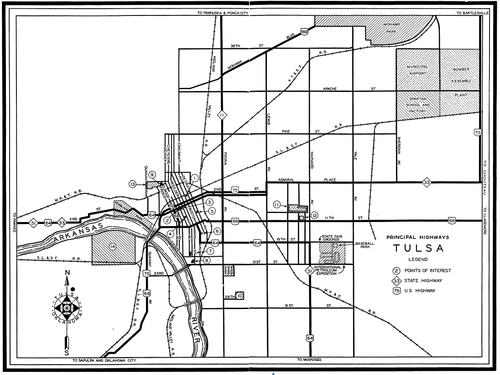
3. Follow the old highway routes through town: Look for a map from the 1950s or earlier showing the streets that were designated as US or state highways, and then drive the road between downtown and the outskirts of town. On the edge of the city, you'll find commercial architecture from the heyday of the family road trip: old motels and tourist courts, diners, gas stations, tourist traps, and curio shops. This is where you're likely to find flamboyant neon signage designed to catch the eye of a weary dad behind the wheel of his station wagon. While roadside architecture along the interstates looks the same from one end of the country to the other, back before the interstates roadside buildings bore the imprint of local character and local imagination. Here you may still find cafes that once catered to tourists and truckers but now mainly serve the locals.
Closer to town, the old highways are likely to take you past the kind of neighborhood commercial districts which are often incubators for urban revitalization. Tulsa's Cherry Street developed along what was once U. S. 64, the main road between Tulsa and Muskogee and Ft. Smith. This is where you might find an interesting antique shop or a hip coffee house.
You might be able to find this sort of map in the state's WPA Guide. Many state highway departments have posted scans of old official highway maps online: e.g. Oklahoma, Kansas, Missouri.
4. Hang out in an indie coffeehouse: You don't have to answer all your email from your lonely hotel room. Find a friendly locally-owned coffeehouse with wifi. These places often serve as de facto community centers, and the bulletin board and the barista can tip you off to live music, gallery exhibits, festivals, lectures, and other types of local flavor. I always check IndieCoffeeShops.com, a crowd-sourced database that uses Google Maps to help you locate coffeehouses. When I find one that isn't listed, I give back by adding it to the IndieCoffeeShops.com database. You can filter the search for wifi, food (more than just pastries), beer and wine, and whether or not smoking is allowed and outdoor seating is available. UrbanSpoon is another way to search for cafes, pubs, and restaurants with free wifi.
5. Check out the local alt-weekly: Many alt-weeklies publish an annual "Best of" edition that will clue you in to the locals' favorite places to shop, eat, drink, and play. You can usually find the most recent "Best of" on the paper's website. The latest edition (likely available at the aforementioned indie coffeehouse) will give you a calendar of events and often interesting feature stories spotlighting local issues, performers, artists, and eateries.
Wireless networking and DHCP aren't complicated. They ought to work every time, but they don't.
I recently spent a couple of weeks in what was built as a Residence Inn (separate buildings, with eight suites in each) and is now affiliated with a different national chain. Nice place, good price, quiet, and the staff is friendly.
They provide wireless internet with a DSL modem and a wireless router in each of the buildings, each router with its own SSID. I could usually see four or five when I looked for available networks. I never could connect to the internet through the router in my own building, despite the fact that it was right behind the bed's headboard.
When you connect to the internet via wifi, there are three main things that happen. (This is, of course, an oversimplification.) The first is the computer and the router make a connection on a certain radio frequency using a particular signal protocol (some variety of IEEE 802.11). Once you've made this connection, it's just like you plugged an Ethernet cable into your computer.
The second thing that has to happen is the router has to give your computer an IP (Internet Protocol) address. That's four numbers between 1 and 254, separated by periods, e.g. 192.168.1.55. Without an IP address, you can't do much -- the protocols your computer uses to send web requests and receive web pages (HTTP) and to send and receive email (SMTP, POP, IMAP) all use IP addresses to get data where it needs to go.
Once upon a time, you had to change your IP address manually (and reboot, usually) every time you connected to a new network. (Tools like Netswitcher were a godsend.) Nowadays, when you connect your computer to a network (whether wired or wireless), your computer sends out a request for an IP address and an IP-address-giver-outer (known as a DHCP server; this task is usually handled by the router) responds with an address that isn't already in use. At least that's the way it's supposed to work.
But your computer probably doesn't know the IP addresses for your favorite websites, and that brings us to the third essential step: Getting the IP address of a computer, called a DNS server, that can translate computer names (like www.batesline.com) to numbers. In the early days of the internet, when the number of connected computers were relatively small, each computer on the net had a long file (/etc/hosts) with a list of names and IP addresses, a list that had to be updated by hand every time a new computer was added or an IP address or host name changed. DNS -- Domain Name Service -- was developed to handle all this automatically. When you connect to a network, the router not only assigns your computer an IP address, it tells your computer the IP addresses of two or three DNS servers.
In a dream world, all three things happen automagically behind the scenes, and within seconds of connecting, you're ready to surf. Lately, though, I connect to a wireless network and almost as often as not, I get the dreaded "Limited or no connectivity" error. This means that even though my computer and the router are on speaking terms, the router has not seen fit to give my computer an IP address. Instead, Windows assigns a fake address that does no good.
During my business trips, I connect to a lot of different networks -- at the hotel, at the job site, at coffeehouses and restaurants. I would consistently get an IP address on some networks and would consistently get the "limited or no connectivity" error on others. Lately the problem seems to happen more often than it used to. I've looked for solutions on the internet, but no one seems to know what causes this to occur. The suggested courses of action seem like snake oil or folk remedies. If some tactic did work for someone, nobody can explain why it worked. The problem continues to exist even for Windows 7 users.
As I mentioned, the nearest router at the hotel was behind my headboard, and the front desk gave me their blessing to cycle power and see if that helped. It didn't.
So consider this a cry for help. Few things are more frustrating than getting settled in with a cup of coffee and discovering that you can't connect to the coffeehouse's wifi. Or having to settle for a low-speed, weak, distant connection, because the five-bar signal across the room won't assign an IP address.
I'd welcome any suggestions.
Business has had me in Wichita fairly often over the past few weeks. I was telling a friend about my recent sojourn, and she replied that she'd driven through Wichita a few times and couldn't "get on board with the whole Kansas thing." I'll admit that I didn't have a high opinion of Wichita before work brought me there. And the Kansas scenery as seen from the interstate gets a bit monotonous after a while.
For most Tulsans, Wichita is a place to drive through on your way to the ski slopes of Colorado. If you were to get off the highway, you'd find shady neighborhoods filled with late Victorian and craftsman homes, historic downtown buildings both big and small, and a warehouse district (Old Town) turned into a lively collection of restaurants, lofts, theaters, and hotels. But you have to get off the expressway to see it.
That's true in general of Kansas. If you get off the interstate and drive the old roads, you'll find pretty small cities and towns with well-preserved Main Streets and shady neighborhoods -- Emporia, Independence, Winfield, Arkansas City, Lindsborg, McPherson, Abilene, Chanute, Fort Scott -- to name just a few. I can better appreciate the beauty of open farmland if it's interrupted every so often by an attractive town.
Any time I travel, I try to make the opportunity to get out of the zone of chain hotels and chain restaurants and to get to know the city. I look for locally-owned restaurants and interesting neighborhoods, and I spend a lot of time on foot seeing what a city has done with (or, too often, to) its downtown.
One of the things I look for is a place to hang out -- a place with free WiFi, late hours, and something good to eat and drink, where they won't mind me sitting around to write code and blog entries for a few hours. I could work in my room, but that gets a bit lonesome after a while. And sometimes the hotel internet access is slow, or blocks VPN, or just doesn't work, so it's good to have an alternative.
While Tulsa has a great assortment of such places -- Coffee House on Cherry Street, Shades of Brown, Cosmo, to name a few -- I've had trouble finding such places in other cities. Wichita, on the other hand, is blessed with an abundance of great late night coffeehouses. As a bonus, most of them are conveniently located near I-135, so you can easily hop off for some caffeine and internet access on your way to Breckenridge.
Here are four worth a visit:
Riverside Perk: In a pretty late-1800s neighborhood in a bend of the Little Arkansas River, there's an old two-story wood-frame building at the corner of 11th & Bitting. The ground floor had a grocery store and a drug store once upon a time; today it's a coffeehouse and a wonderful neighborhood gathering place. You can sip your coffee and work on your laptop at a big diner booth and look out the big front windows to the big front porch and shaded sidewalk tables. A smoothie bar in the next room offers bar seating with a tiki theme. Riverside offers a great assortment of specialty drinks and food, including pizza bagels and sandwiches. They're open until 10 weeknights, midnight on weekends, when they have live music. Before or after your coffee, it's a pretty neighborhood for a stroll. From the interstate: From I-135, take the 13th St. exit and head west about a mile and a half, past the spectacular art deco Wichita North high school and across the art deco Minisa Bridge to a light at Bitting Ave. Left (south) on Bitting, across another bridge, then two blocks to 11th St.
The Donut Whole: A rooster stands sentinel on the roof of the sturdy brick building on Douglas between Hydraulic and I-135. Two rooms are connected by a narrow hallway. The room close to the street has roomy diner booths and a stage for weekend live music. The room at the back houses the coffee and the donuts, an old pinball machine ("Airport" by Gottlieb) -- two plays, five balls each, for 25 cents. A yellow Anco wiper blade display serves as the condiment table, next to a Lions Club park fountain on a pedestal. In the corner is Seeburg 100 jukebox (for sale), sitting under an old Fair-Play basketball scoreboard. Eclectic music (Django Reinhardt, The Price Is Right theme, early Beatles) fills the air. The coffee is excellent, and the assortment of donuts is astounding: choco crunch, Homer J., peanut butter cup, creamy orange, fluffernutter, thick mint, sunshine citrus crunch, peanut butter and grape, and triple bacon, to name just a small sampling. There's a cooler full of specialty sodas like Boylan's and Mexican Coca-Cola. Open 6 am to midnight, live music on the weekends, drive-thru open 24/7. From the interstate: Easiest coffeehouse to reach from the highway. From I-135, take the 1st/2nd St exit and head west on 2nd about two blocks to Hydraulic. Left (south) on Hydraulic two blocks to Douglas, then left again (east) and look for the rooster on the roof on the north side of the street. Parking available alongside the building.
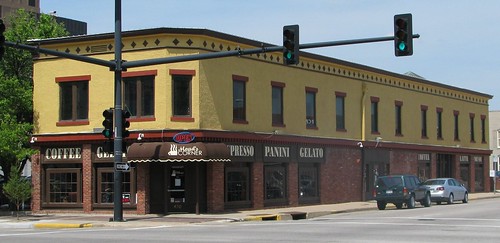
Mead's Corner: This coffeehouse on Douglas at Emporia downtown offers coffee, specialty drinks, tea, gelato, pastries, and sandwiches, wraps, panini, and salads. Lots of room -- the coffeehouse takes up the entire first floor of an old commercial building -- with different types of seating, and great views of the other historic buildings nearby. Mead's Corner is owned and operated by First United Methodist Church, but it's not a haphazard "ministry" but is in fact run very professionally. (I'm sorry to say I've known of other church-related coffeehouses with very limited schedules and poor-quality coffee.) At the same time, it provides a comfortable venue for spiritual discussions, as well as the usual coffeehouse assortment of live music, poetry slams, etc. Mead's opens at 7 am Mondays through Saturdays until 10 weeknights, midnight on the weekends. Sunday hours are shorter: 10 am to 6 pm. From the interstate: From I-135, take the 1st/2nd St exit and head west on 2nd. You'll go through Old Town, under the Santa Fe tracks, then make a left on St. Francis. Go two blocks to Douglas, turn right and go one block west to Emporia. Street parking is free -- up to two hours during the day.
Poetic Justice: This one's different -- not near downtown, but in a strip center on the eastern edge of Wichita at Webb and Central on Greenwich north of Kellogg, very near the Beechcraft Hawker aircraft factory. It's also convenient to the hotel cluster near the I-35 Kellogg exit. Everything seems very new and neat. They sponsor weekly game nights (Wed), craft nights (Thurs), and open mike poetry nights (Fri). Open 9 am to midnight M-F, 10 to midnight Saturday, and closed Sunday. From the interstate: From Kellogg Ave (US 54-400), head north on Greenwich Rd; the cafe is just a few blocks north on the east side of Greenwich. Greenwich Rd is just a little over a mile east of the Kansas Turnpike (I-35) Kellogg exit. (UPDATED to reflect Poetic Justice's new location.)
Free WiFi seems to be getting more and more common. Spangles, a local '50s-themed fast food chain, has WiFi and late hours, as does Emerson Biggins, a local sports bar chain. I spent an evening at Pacific Coast Pizza enjoying a Fresno pizza and watching a TMAPC PLANiTULSA hearing on TGOV. There's a Village Inn on Rock Rd. with WiFi, new decor, and a new logo -- the restaurant's initials in lowercase sans-serif -- it ought to attract Unix developers.
Past entries on Wichita and Kansas:
The lonesome road to Wichita (alternatives to I-35)
Places to see in Wichita (including the amazing Orpheum Theater
A FUN-FUL evening in beautiful Kansas (Riverside Park in Independence)
Independence, Kansas, is FUN-FUL
A happy place in Kansas (College Hill Coffee in Winfield)
Useful sites for finding free WiFi:
IndieCoffeeHouses.com -- a Google-maps based, crowdsourced database of independent coffeehouses.
WiFiFreeSpot.com
OpenWifiSpots.com
Hotspotr.com
I'm not normally a bubbly person, but I'm feeling pretty cheery at the moment. I'm on my way home after a long stretch of long workdays in Wichita. I got a later-than-planned start and left town without eating. I decided to stop in Winfield, Kansas, at a coffee house there. I figured I could get some dinner, check e-mail, and get caffeinated for the rest of the drive.
What I found when I arrived at the beautiful craftsman bungalow that houses College Hill Coffee was an amazingly good jazz quintet. The pianist sounds like Vince Guaraldi and the guitarist has a style reminiscent of Eldon Shamblin. When they broke into "April in Paris," I broke into a grin.
For the record, the quintet is Prof. Mike Jones, trumpet; Scott Williams, piano; Tom Hoeffgen, guitar; Lee Velasquez, bass; and Nick Hofmeister, drums. I assume "Prof." implies a connection to Southwestern College, just a block from here.
It's a bit off the fast (but deadly boring) route between Tulsa and Wichita, but College Hill Coffee will be getting future visits from me, I feel sure.
MORE COFFEE: I've added College Hill Coffee to the map at IndieCoffeeShops.com, a Google Maps-based, crowdsourced guide to independently-owned coffeehouses around the world. IndieCoffeeShops.com guided me to three great hangouts in Wichita -- more about them, and Wichita, in a future entry.
STILL MORE: Scott Williams, the quintet's pianist, posted a comment below. He has posted a number of YouTube videos of the Winfield music scene, including several from the evening at College Hill Coffee. Here's one -- "Spring Is Here."
Because this is a long entry, you'll need to click the "Continue reading" link to see the whole thing. Clicking any of the photos will take you to a bigger version and my full set of San Antonio streetscape photos. If you're interested in hotels, restaurants, historic preservation, and entertainment in San Antonio, read on....

Once again last week, business took me to San Antonio. It was a productive trip. We worked second shift instead of third, which was much more pleasant. I was awake enough during the day to get out and enjoy the sunny 60-degree weather.
One of the things I love about San Antonio is the strong commitment to historic preservation, a commitment that dates back almost 90 years. The San Antonio Conservation Society was founded in 1924 "to preserve the 'antiquated foreignness' embodied in San Antonio's charm and character," and it has been successful in that regard, but as a happy side effect, the society's efforts have also succeeded in preserving the early 20th century commercial buildings that were brand new or not even built when the society was founded. The result is a bustling urban downtown as an attraction for tourists and conventioneers.
The story of the San Antonio Conservation Society is worth reading. Like a similar organization in Savannah, it was founded by prominent and wealthy women who were outraged at the threatened destruction of a historic market. And as in Savannah, San Antonio's preservationists lost their first battle but went on to create a culture where history is cherished.
The ladies of the Conservation Society came up with creative ways to make the case for preservation:
In September 1924, after sketching the Commissioners at their weekly meetings, the ladies presented a play called, "The Goose with the Golden Eggs." They performed their play after the commissioners' regular meeting with puppets crafted to look like the men themselves. The commissioners of the play were called upon to arbitrate an argument between Mr. and Mrs. San Antonio over whether San Antonio's character and charms should be killed to achieve prosperity more quickly. Of course, the Conservation Society members in the audience responded, "NO," and many cheered. Preservation of the city's character and charms would reap greater long-term benefits, including civic pride, than the mere accumulation of money.Their response to the notion of filling in the Great Bend, which had been a recommendation in an engineering report, was to take the City Commissioners on a canoe ride on the bend just to show the men how beautiful it was. Many of them had never seen the river from that perspective before and were greeted along the way by children waving and pitching flowers to them from the bridges.
It's always a surprise to get a comment on an old post, usually a pleasant one.
Over the last 24 hours, two old blog entries have received comments.
The first, from Lisa S. of Joshua, Texas, was posted to my July 2008 entry about a visit to the pictographs at Paint Rock, Texas. Last week, she and her dad were heading back home from visiting the town of Paint Rock and decided to follow the signs to the pictographs. I guess she was looking on the web for more info, came across my writeup, and was kind enough to report her own wonderful tour of the pictographs.
The second, from Howard Giles, posted from an Albuquerque, N.M., IP address, complains bitterly about my May 2009 entry on a 1981 Downtown Tulsa Unlimited plan for redeveloping what we now call Brady Arts District (or, better, the Bob Wills District). I had quoted from an April 7, 1981, Tulsa World business news story on the plan, which included extensive quotes from planner John Lauder of Urban Design Group. Mr. Giles thinks I should have done further research -- actually sought out a copy of the plan -- before writing anything about it. I replied: "It's not meant to be a finished piece of research, just a snippet of information I thought deserving of wider exposure. I let my readers know the source of the information and where it could be found so that an interested reader could do further research on his own." In my reply, I invited Mr. Giles to share any specific information he has about the 1981 plan.
Getting caught up:
Early last month (best defined as the very cold windy period between the big Christmas snowstorm and the big late January ice storm), I had two back-to-back business trips, both involving graveyard-shift hours, separated by less than a day at home. The first trip was to Altus AFB, in southwestern Oklahoma.
Altus and I go back 22 years, with trips to work on C-141 and KC-135 simulators in (approximately) 1987, 1996, 1997, 2000, 2006, and 2007. While there's one fastest way between here and there -- I-44 to Lawton then US 62 to Altus, there are plenty of other paths, and I took as many as I could to see as much of southwest Oklahoma as I could -- Cordell, Hobart, Hollis, Granite, Gotebo, Burns Flat (once home to an Air Force Base of its own), Clinton, Weatherford. When I learned at the 1998 National Preservation Conference that Oklahoma had one of the top Main Street small-town revitalization programs in the nation, I could believe it because I'd seen the results in many of these towns.
If I didn't have time to get too far off the straightest route, there were still some interesting but brief diversions along the way. US 62 is now straight as a string from west of Lawton to Altus, but before the 1970s, US 62 followed the railroad and the terrain and passed through several towns: Cache, Indiahoma, Snyder, and Headrick. Most of that old US 62 alignment still exists as county-maintained roads; the Snyder loop is still a designated highway -- US 62 Business.
My very favorite piece of this old road was a four-mile segment, beginning 10.5 miles east of the center of Altus, looping off to the south, through Headrick, then across the North Fork of the Red River and a railroad before rejoining the main road west of Snyder. This piece of road nicks the northwest corner of Tillman County -- an important fact to which I'll return later.
Here's what I wrote about it after a trip three years ago, in a blog entry about the scenic route between Altus and Medicine Park that I started but never finished until tonight:
The road skirts the northern edge of the little town then winds through some some rocky hills and over a long pony truss bridge across the North Fork of the Red River, followed by a through truss bridge over a railroad. The old concrete roadbed, the old style bridges, the pale orange rocks, and the mesquite trees combine to look like a fading slide from a summer vacation out west circa 1947.
The concrete of this old road is in exceptionally good condition, and as I prepared to head back to Tulsa at the end of my most recent visit, I was looking forward to driving it.
But there was a problem:
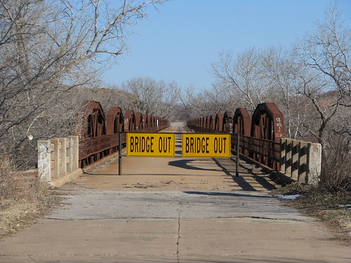
The problem became an opportunity. While I had driven this road several times before, I had only seen it at 35 or 40 miles per hour. It was a sunny, cold day, but I was bundled up and the wind wasn't too bad, so I decided to go for a walk.
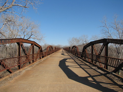
The walk gave me a nice view of the North Fork of the Red River, once claimed by Texas to be the main branch of the river and therefore the border between Texas and Indian Territory. To the west, between the two forks of the Red and the 100th Meridian was Greer County, Texas. A U. S. Supreme Court decision in 1896 proclaimed that this land belonged to Oklahoma. (Here's Texas' side of the story.)
The shallow river was still mostly ice. This photo is looking south toward the BNSF (formerly Frisco) tracks.
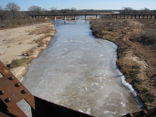
The bridge and road are actually in very good condition, but the railroad overpass beyond it is closed and in need of repair.
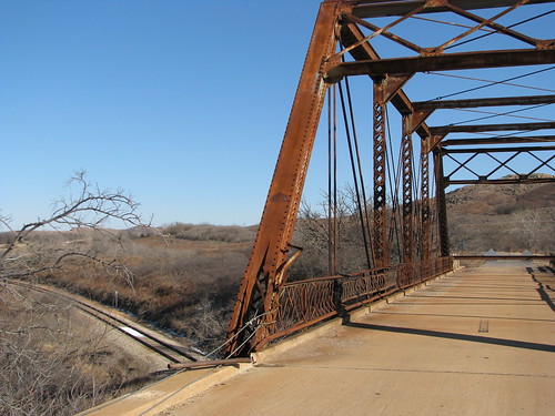
With the railroad overpass closed, the river bridge (when it was open) formed a very lengthy cul-de-sac, a fact that seemed to have been noted by the area's unruly youths:
According to the Oklahoma Bridges website, the river bridge was closed in October 2009. Built in 1929, the bridge has 23 trusses, is 1,924 feet long. The posted weight limit is 17 tons. It was US 62 until a new, more direct alignment between Altus and the river was opened in 1970.
Regarding the railroad overpass, the Oklahoma Bridges website says:
The left endpost looks as though it was struck, as all the concrete guard rail is missing on the north side of the west approach, and the cover plate on the endpost is damaged. Despite these deficiencies, the bridge was given satisfactory and fair marks in its 2007 inspection. Despite this, and despite the fact it is a heavy bridge, Tillman County decided to close this bridge on Oct. 26, 2009....We at Oklahoma Bridges are hopeful that repairs will be made to this bridge and that it will be reopened. Its closure has also affected another nearby bridge, the Old US 62 North Fork Red River Bridge, which was also closed by neighboring Jackson County because, with this overpass bridge closed, the river bridge dead ends.
So back to the car:
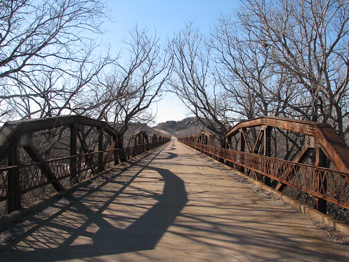
(After the 1.5" of ice they got in late January, I'll bet those trees aren't overhanging the road anymore.)
And back down the highway...
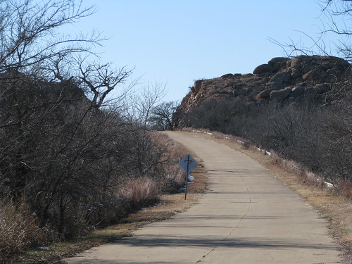
... to my next adventure:
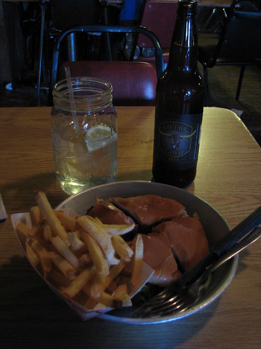
Click any of the above photos to see bigger versions and to explore the rest of my Flickr photoset of my southwest Oklahoma trip, including photos of a monument to the vanished APCO refinery in Cyril and interesting buildings in downtown Altus (before the massive ice storm that knocked power out for more than a week).
Alumni of American Airlines' Sabre reservation system will gather Friday, January 22, 2010, at Mulligan's, in the Radisson Hotel on 41st St, between US 169 and Garnett Rd.
Here's the text of the invitation that's going around by e-mail:
Come celebrate the 30th anniversary of the NY to TUL migration!
All are invited...
old friends & new friends,
transplants & native Oklahomans,
current & past employees of
AA, HP, EDS, and Sabre...
to an informal gathering
at Mulligan's located inside the
Radisson Hotel on
41st St. just east of Hwy 169
(between Mingo and Garnett)
Friday, January 22 nd, 2010
5pm-9pm
I'm nearing the end of two business trips in one week, separated by less than 16 hours at home, both involving graveyard-shift hours.
The first was to Altus, in southwestern Oklahoma -- drove down on Wednesday, worked the wee hours of Thursday, Friday, and Saturday, slept a bit, then drove home late Saturday afternoon with a couple of self-indulgent stops: taking pictures an abandoned stretch of US 62 east of town, followed a short while later by a Meers burger.
Back in '87 I spent six weeks over a three month period in Altus for Burtek with a team of about 10 engineers, installing and testing a simulation written in Ada to control a C-141 full-flight simulator. It was my first major site trip as an engineer, and going back to Altus brings back a lot of memories, most of them positive. It was strange to see what had been the Ramada Inn, the nice new hotel in town in '87, with an indoor pool and restaurant, now a Motel 6. The nice new place in town these days is the Holiday Inn Express, a bit further east.
Got in Saturday evening in time to give the four-year-old a bath, read to him and his big sister, hear the 13-year-old's enthused description of Avatar in 3-D, get a couple of loads of laundry done, then deliver a computer chassis back to the office, then about five hours sleep. Sunday morning involved turning in the rental for the Altus trip (a Ford Fusion -- pretty nice car), going to church, going back to the rental office to pick up the Pikepass I'd left on the windshield, lunch at Delta Cafe -- vegetable plate, to make up for what I ate in Altus -- then off to the airport.
At the airport, I met up with a colleague from my FlightSafety days, off on a site trip of his own. We wound up next to each other on the plane, and it was good to get caught up.
The Thrifty van driver was playing a local Christian radio station playing a type of music you don't hear much any more -- neither 18th century Charles Wesley or Isaac Watts, nor 21st century emergent church grunge, but hymns and gospel songs from the late 19th, early 20th century -- the songs of my Southern Baptist childhood and my dad's childhood, too. I tuned my car radio to the same station and harmonized best as I could remember from the Baptist Hymnal (1956 edition). On the drive to the work site at 2 a.m., they were playing Alexander Scourby's reading of Genesis 31-33 from the King James Version.
During off-season, you can find a hotel room downtown San Antonio about as cheaply as one out on Loop 410, and downtown is far more interesting. For a short trip in December, I stayed at the O'Brien Hotel, a 10-year-old boutique hotel in an old three-story commercial building, just about a block from the River Walk and La Villita. This time, someone else picked the hotel, the Hampton Inn, northeast of the Alamo. The large surface parking lots between the hotel and the Alamo makes this a much less appealing part of downtown.
It was unusually chilly for San Antonio. I set out for the Riverwalk to find a place to eat, only to discover that the river was gone! This, evidently, is the time of year they drain the loop to dredge and clean the river bed. A few pubs and eateries were closed, as were some of the sidewalks.
Since I had to be at work at 2 a.m, I decided to have breakfast for dinner and had an Ulster fry-up (bacon, eggs, sausage, tomato, beans, toast, and mushrooms) and an overpriced Guinness at Mad Dogs Pub. I went back to the room, finished reading Ender's Game (which had come highly recommended by my 13-year-old), and took a two-hour nap.
Work on site was done about 8, but I wrote up my trip report and answered e-mail as I had the hotel's breakfast for dinner. Finally got to bed about 11 and slept 'til 4:30 with Fox News droning in the background to drown out any extraneous hall noise. (Glenn Beck woke me up.)
My walk to get something to eat took me past a building that holds a historical scale model of the Alamo as it was in 1836. Price of admission was $3, and it was well worth it. There's a view of the excavation under the building, showing layers of debris from different periods, including a layer, about two feet down, with cannon balls, horseshoes, and animal bones. There's a recorded story to go with the diorama, and it's narrated by drummer, vocalist, and Alamo enthusiast Phil Collins. Spotlights on the diorama highlight the component buildings of the fort as Collins describes them, and then backed by the Degüello -- the haunting bugle call meaning "take no prisoners" -- Collins tells the story of the battle. The presentation helped me get a better sense for how the siege and battle progressed.
The diorama is connected with The History Shop next door, which specializes in antique maps, documents, books, and weapons.
Just west of the diorama is the Emily Morgan Hotel, a 1924 Gothic Revival building that has some Philtower-like gargoyles depicting various medical ailments. (Originally, it was the Medical Arts Building.)
The stroll onward took me past a new Walgreens at Houston and Navarro. The building was completed last year, and it replaces an older Walgreens that had been there since the '30s. The new building retains the old neon signage and has the form of the old, but the new store is about twice as big. The upper stories of the old building were unused; the new building has offices in its second story. It's a very nice job of urban infill.
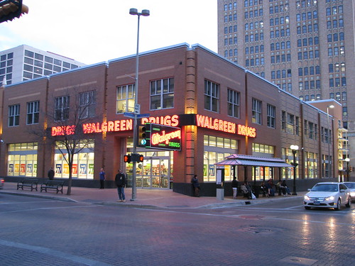
Dinner was at Schilo's deli, just next door to Casa Rio on Commerce Street. This is an old fashioned German deli, and it was hard to decide which dinner entrée to choose. I went with the jaegerschnitzel, accompanied by German potato salad, a delicious cup of split pea soup, and a chilled mug of Spaten Optimator.
MORE: Before heading home on the 12th, I had some time to take more photos around downtown, including the San Antonio Express-News building, and daytime shots of the drained San Antonio River, and time to have lunch at Schilo's. The pastrami was underwhelming (thin sliced, lean, not steamed), but the split pea soup and homemade root beer were good.
(Finished at last and posted on February 19, 2010.)
BOOKMARKED: Memories of San Antonio places from someone who left in 1961. Many of the photo links are dead, but the narrative is interesting.
I was googling for a restaurant sign in an old photo of Bob Wills' tour bus, the restaurant turned out to be the Old Tascosa in Amarillo's Herring Hotel. The Herring Hotel, like Tulsa's Mayo and Oklahoma City's Skirvin, is still standing but has been closed for over 30 years, waiting for someone to bring it back to life.
My search led me to this wonderful page of Amarillo postcards, photos, and news clippings, mainly from the 1960s. I've never been to Amarillo, but the pictures still managed to inspire some nostalgia, as I saw a number of places that were familiar from Tulsa's past. For example:
- A Zuider Zee Restaurant -- Tulsa had one on the north service road of I-44, east of Memorial Drive.
- Woolco, a department store that would anchor Amarillo's Western Plaza Mall in 1967, just like Tulsa's Woolco at the western end of Southroads Mall, two years later.
- A Shamrock gas station (before the shamrock leaves became diamonds)
- A Ramada Inn neon sign, with the innkeeper and his horn -- Tulsa's was on the south I-44 service road, west of Yale
- T. G. & Y. (5¢ TO $1.00)
- Furr's -- here it's always been a cafeteria; in Amarillo it was a grocery chain
- A neocolonial Borden Milk plant, just like the one that used to stand on the southwest corner of 51st and Garnett
- Plenty of roadside hotel chains along Route 66 -- Howard Johnson and Holiday Inn
- Local motels with cool mid-century architecture and neon
- Restaurants with Japanese-style architecture and faux Chinese food -- chop suey and chow mein -- like Tulsa's Pagoda
Here's another page of Amarillo pix with
- a downtown much like ours once was
- drive-in theaters and drive-in restaurants, including a Griff's Burger Bar (ours was on 21st up the hill from Sheridan)
- a streamline deco bus depot
- a downtown building with a lighted tower that showed the weather forecast
- a Downtowner Motor Inn -- ours is still standing at 4th and Cheyenne
- Polk Street -- the main drag -- all lit up at night
PLANiTULSA's draft vision, developed by Fregonese Associates in response to the PLANiTULSA scenario survey, will be available after 2 p.m. today, September 15, 2009, at PLANiTULSA.org. City of Tulsa planners are seeking feedback on the draft, which is not a detailed comprehensive plan, but a first step in that direction, defining in broad terms what kind of development is desired and where. An open house on the vision and small area concepts will be held at the Greenwood Cultural Center a week from Wednesday, September 23, 2009, from 4:30 to 8 p.m., with formal presentations at 5:30 and 7.
It will be interesting to see if the draft vision emerges as an issue in the ongoing City of Tulsa elections.
Also, tonight (September 15, 2009), the Oklahoma Department of Transportation will hold a public meeting about Tulsa's place on a high-speed rail corridor tonight at 6 p.m., at the Aaronson Auditorium at Central Library in downtown Tulsa. Meanwhile, last week, ODOT began demolishing the platforms and rail yard of Oklahoma City's Union Station. Oklahoma rail activist Tom Elmore comments:
If "High Speed Rail" and an Oklahoma hub are important enough to ODOT that it would seriously apply for "2 billion federal dollars," then why isn't saving the OKC Union Station rail hub at 300 SW 7th an even greater priority? (ODOT contractors started destroying the rail yard there last week -- the "week of 9-11-09.")ODOT's clear message? If Oklahomans are going to have advanced surface transportation, they're going to have to pay ODOT's favored contractors for it "at least twice..." (We're being forced to pay those contractors to destroy magnificent, 8-block-long OKC Union Station yard -- and we'll be forced to pay to build a new one, of predictably lower quality, if they ever actually get around to that!) ... or are they just using an "alleged interest" in High Speed Rail to cover their crimes at OKC Union Station?
Time for Oklahomans to demand answers!
July 25, 2009: Hustontown, Pa.
Our arrival was timed so that we could attend the monthly get-together at the Hustontown Volunteer Fire Department, an open stage night where locals gather to play music, to listen to music, and to visit with one another. Refreshments (including homemade pies) are sold to raise money for the fire department.
The house band is led by a longtime volunteer firefighter, and the group accompanies most of the other performers. Our two oldest kids each signed up to play (fiddle and piano, respectively).
I didn't know what kind of music to expect from amateur night in the middle of rural Pennsylvania. I would never have expected it to be the same sort of music you'd hear at such an amateur night in Kentucky or Arkansas or Oklahoma.
Earlier that day, as we drove through southwestern Pennsylvania, my wife and I were struck by the number of Ulster place names we saw. Two vacations (B.C. -- before children) took us to Counties Antrim and Tyrone and Donegal and the cities of Belfast and Derry, partly in search of traces of my Scotch-Irish ancestors. I knew from some of my genealogical reading that many Ulster Scots who came to America in the 1700s entered at Philadelphia and settled inland; first in Lancaster County, then further west into the Alleghenies, and then south into the Shenandoah Valley, the Cumberland Gap, the Holston Valley, and then, in the 1800s and 1900s, westward to places like Texas, Oklahoma, and California's Central Valley. It was easy to see how Scotch-Irish settlers from the glens of Antrim or the Blue Stack Mountains of Donegal would have felt right at home in western and central Pennsylvania.
A couple of weeks ago, Philadelphia-based blogger Skye made this observation on Twitter, as she drove west to Pittsburgh for the Right Online conference:
So, this is alabama in between
I'm not sure what she saw to lead her to that conclusion, but it makes sense. (I was surprised at the number of Confederate battle flags I saw flying around Fulton County. Not a huge number, but more than the number I expected -- zero.)
The culture of northern Alabama and the culture of south central Pennsylvania are bound together by this Ulster Scots heritage, a heritage that is so ubiquitous in America that it is as invisible as the air that we breathe.
I mentioned the music at the open stage night: There was western swing, there was classic country (e.g. Hank Williams), and there was traditional gospel (e.g., "I've Got a Mansion Just over the Hilltop"). The latter style had many in the crowd singing along. The house band included fiddles, a banjo, an accordion, a pedal steel guitar, and a bunch of electric basses and electric and acoustic guitars.
What clinched the connection for me was the opening tune: A couple of choruses of Bennie Moten's "South", recorded in 1928. Moten was a Kansas City native, and his band included the Kid from Red Bank (as Johnny Martin called him) -- Count Basie. The song entered the western swing repertoire via Bob Wills, who used it each night to lead off his dances. Is it just a coincidence that the Hustontown Fire Department house band opened with the same tune over 70 years later?
Here's my oldest son performing a traditional Irish tune called "Tam Lin" and the classic western swing number, "Faded Love." I love the way the band comes in behind him on Tam Lin. There was a bit of a hiccup on a key change in Faded Love, but everyone got on the same page eventually. I'm proud of him being willing to go up in front of a hundred or so strangers and play with a dozen musicians he'd never played with before.
I was proud of my little girl, too. She played her two recital pieces from Barthelmes -- "Snake" and "Relay Race" -- and remembered to take a bow at the end:
The three-year-old was wiped out from the long drive. Here's one of his few moments of alertness and a more typical moment a short while later:

But he was awake for ice cream. After the show, we headed to a local favorite spot -- the Twist and Shake -- which specializes in unusual flavors of soft serve ice cream. That night the special flavors were chocolate marshmallow and peanut butter. Another night they had grape nuts ice cream and teaberry ice cream. (Teaberry tastes just like Pepto-Bismol.)
Back at the house, we caught fireflies for a while before turning in for the next day's big adventure: A ride on a real steam train.
Day 3: July 25, 2009, Columbus, Ohio, to Hustontown, Pa., via I-70 and I-76, 320.9 mi., 6:41 en route.

The third day of driving included a swing through historic Zanesville, Ohio, and across its unusual Y bridge and a stop at Wheeling, W. Va.'s Italian Festival on the Ohio River waterfront. Click the "read more" link to read all about it (and see some pictures, too).
Day 2: July 24, 2009, Pacific, Mo. to Columbus, Ohio, via I-44 and I-70, 479.9 mi., 11:30 en route (plus one hour lost to the time change).
11 a.m. was a later start than I'd hoped for, but it was much better than the day before. We sailed through St. Louis without a snarl. The kids were under a no-books, no-DS order until we passed through the city so that they might actually pay attention to what we were driving past. Interest was expressed in going up in the Gateway Arch, but we were too far behind schedule for that to work; we'd try to fit it in on the return trip. I made sure to call their attention to the Eads Bridge, the Mississippi River, and the near-ruin that is downtown East St. Louis. The oldest boy noticed a tall building that no longer had tenants or even windows: "You can see all the way through it!"
We hit construction delays as we approached the point where I-70 and I-55 split, so I opted to drive a while on US 40. That two-lane road was backed up by what looked to be a serious accident. I gave up after about 10 minutes, confessed to my bad call, turned around (traffic was stopped in both directions) and headed back to the jammed interstate. But before we reached the on-ramp, I spotted a streetsign for "Old National Rd." The old highway led us through the village of Troy, Ill., then back to US 40, which we followed through the town of Highland, settled, according to a book I have on the National Road, by Swiss immigrants; the influence was apparent in some of the town's older buildings.
The current alignment of US 40 doesn't go through Highland, but bypasses it. Having missed the spot where the older alignment splits off to go through the main part of town, we turned south on Poplar, following the signs for the business district. I took a guess, based on years of experience following old highway alignments, about which street would take us east out of town on old US 40. After a few blocks it appeared that my guess was wrong, so I pulled into a subdivision, consulted Google Maps on my Treo, and, correctly oriented, got us back on track. Our path back to new US 40 and I-70 took us past a farmhouse with beautifully decorated shutters, spangled with stars in what we guessed was a traditional Swiss immigrant pattern. (Didn't get a picture, sadly.)
As we were nearing three hours on the road and people were complaining about hunger, I decided that we would stop at the Vandalia McDonald's. It had a Playplace, which would give the two younger kids a chance to burn off some energy, and wifi, which would let me get a couple of tasks handled while the kids played. Before the trip, I'd used McDonald's travel planner to find all the locations on our route with a Playplace and wireless internet, and massaged the data into a spreadsheet (a Perl script was involved), which I printed out and put in a binder along with our AAA online Triptik.

Although we often bought sandwiches out, we'd get water and no fries (or maybe one order to share), and make use of our stock of sodas, Vitamin Water, and snacks in the car.
From there, we headed into Vandalia for a visit to the old Illinois State House, which served as the state capitol from 1834-1837 and was the place where Abraham Lincoln first served as an elected official. Foreshadowing the construction of new stadiums to keep the pro sports franchise happy, it was built at local expense in hopes that the legislature would not relocate to another city. (Nevertheless, Lincoln and other upstate legislators made Springfield the capital just three years later.) The rooms had been restored to appear as they would have in the 1830s, with wood-burning stoves for heat and standing desks.
The docent told us a story about the State Auditor's office. When the state offered a bounty for wolves, a hunter had to bring the wolf's scalp to the Auditor in exchange for a voucher, which he then could take to the local bank to receive payment. To prevent someone claiming the bounty more than once for the same wolf, the Auditor kept all the wolf scalps in an ever-growing pile in his office.
 We paid a visit to the Madonna of the Trail statue on the southwest corner of the State House grounds, marking the western terminus of the National Road. The Daughters of the American Revolution placed 12 of these statues, honoring pioneer mothers, along the National Old Trail Road from Bethesda, Md., to Upland, Calif. (The statues are roughly contemporaneous with E. W. Marland's competition for the design of a Pioneer Woman monument in Ponca City, Okla.)
Across the street from the State House is a pocket park devoted to Abraham Lincoln, with a statue of Lincoln seated, reading the newspaper. There is a display telling the story of Lincoln's odd proposal of marriage to a woman he didn't love and how devastated he was when she turned him down.
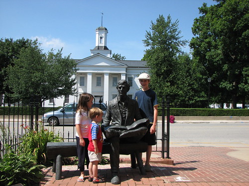
Back on the road after our two hours in Vandalia, we stopped for gas in Terre Haute (my original goal for Day 1's overnight stop) at about 5, then picked up a half-dozen sliders at White Castle for a snack. Reviews were mixed: The grownups liked them; the kids, not so much. We zipped through Indiana, passing through Indianapolis (and marveling at the enormous Lucas Oil Stadium), and taking a break at the Greenfield rest area, which had a pretty wetlands and wildflower area to walk along.
My wife picked up a hotel coupon booklet (RoomSaver) at the rest area, and as I drove she combed through it looking for a good deal along our route. I had hoped to make Zanesville, but the rooms there were scarce and surprisingly pricey. She found a coupon for a Hawthorn Suites on the north side of Columbus. It would take us out of our way, but at $50 it seemed like the best deal. I made the final calls from a gas station just east of the Ohio border, where we stopped for yet one more potty break and to take care of a nasty diaper. (This was an old fashioned convenience store with outside-entrance restrooms and no convenient changing table. Had to change him on the floor with the diaper bag as a pillow. Yuck.)
The kids watched The Return of the Pink Panther for a while, then everyone (except me) fell asleep. We wound our way to the Hawthorn Suites Columbus North, arriving about 11:30 Eastern Time.
Without a doubt, this was the tattiest place we stayed on the trip. It was a converted Residence Inn. The room was large and had a full kitchen, but it was musty, the cabinets had some missing veneer, and there was a big crack across the full-length mirror. It could use some refurbishment, and I was a little surprised that the place met Hawthorn's franchise standards. Nevertheless, we managed to get settled, with the grownups on the double bed, the girl on the fold-out couch, and the two boys on sleeping bags on the floor.
The next morning, the breakfast made up for any deficiencies in the room. Fresh biscuits with real sausage gravy with visible chunks of sausage, and freshly cooked scrambled eggs, along with the usual continental breakfast stuff and the make-your-own waffles. Without a doubt it was the best hotel breakfast of the entire trip. I checked out the breakfast while the rest of the family showered, then we swapped: They ate while I fixed peanut butter and jelly sandwiches for later in the day and got the car packed. We hit the road for Day 3 at 9:22 a.m.
Day 1: Tulsa, Okla. to Pacific, Mo. via I-44, 367.0 mi., 6:20 en route.
We didn't leave until 7 pm.
The plan had been to pack our bags the day before and take care of final errands and packing the morning of, while the minivan was at Cartec for some minor surgery. (The dealership, we believe, had stripped the threads on the bolt that holds the oil pan. Jiffy Lube discovered the problem and installed a temporary fix. We didn't think we should drive more than 3,000 miles on a temporary fix.)
I hoped to make Terre Haute. Then I hoped to make Effingham. I was reconciled to a stop in Vandalia, and by the time we left, I decided I'd be thrilled to make it to St. Louis, which we did.
It always takes us longer than planned to get packed. The challenge is not getting the bags in the car; it's deciding what goes into the bags. My wife thinks and rethinks, wanting to be sure we don't leave anything behind that we might possibly want or need at some point. Plus she was trying to put all that we'd need for the first two nights on the road -- clothes, toiletries, medicine -- into three bags, so even once she'd decided to take something, she still had to figure where it should go.
Only after all the bags are zipped up can I solve the three-dimensional puzzle of fitting them in the car. This did not occur until about 5 pm. I quickly realized that the large rolling suitcase I had packed was simply not going to fit, so in the driveway I swapped the essential contents (clothes) to a roll-aboard suitcase and left the rest (books, mainly) in the bedroom or stowed them in other bags that were going in the car. In the end we had 8 smallish, mostly squishable bags, 2 larger bags, a laptop backpack, and a rolling laptop case. That was just in the back. On top of that we had two sleeping bags and three pillows. Two more big pillows and a small pillow plus three fleece blankets were in the main compartment for the kids' comfort.
The minivan also contained a violin case under the back seat, a large cooler in place of the left middle seat, a rolling hanging file box between the cooler and the driver's seat (containing non-perishable snacks, umbrellas, and travel activities), rolling backpacks for each of the two older kids (normally used or school) containing their travel activities, a small backpack to hold maps and to keep a few cold cans of pop handy up front, two small camera bags, two sets of juggling sticks, a diabolo, two portable DVD players. Around my wife's feet was another bag stuffed with travel activities and books the kids might want to read, plus her purse and at least two canvas tote bags filled with I'm not sure what. The biggest son sat in the right middle seat. The smallest son in his car seat immediately behind, with big sister to his left on her booster and yet another box of toys and amusements (including his Leapster) between them. Big son's job was to pass things between mom and the back seat and was pretty attentive and helpful as long as he didn't have his nose in a book or his Nintendo DS.
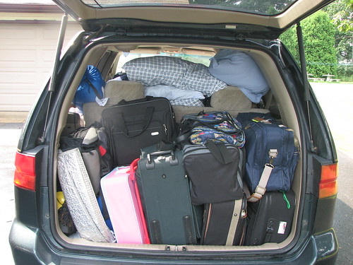 I took these pictures as we unpacked at our first destination, my wife's aunt and uncle's house in Hustontown, Pa. They came in handy five days later when we packed to leave, as I couldn't remember how I'd made everything fit. You can't see the large rolling suitcase behind the two small roll-aboards or the tennis bag at the bottom filled with swim stuff -- suits, sunscreen, goggles, inflatable lily pad. You can barely see the soft-sided light blue suitcase behind the sunshade.
The other problem that always slows our departure is the urge to get certain tasks done before leaving for two-and-a-half weeks, as if we hadn't already been putting them off for at least twice that long. I spent valuable time the night before departure trying to synchronize our digital photos between the laptop and the home computer. (I never did find a way in Perl to get the size or date of a file in Windows. I wound up running a "find . -depth -exec ls -lR {} \;" command in Cygwin on both computers, then writing a Perl script to parse the output and compare the contents of the two drives, then manually copying folders from one to the other. One vexing problem was Windows XP thinking that the high-speed USB ports on the laptop weren't, slowing file copy speed by a factor of 320.)
My watch battery was dying and the case for my Treo was falling apart, so at 1 p.m., when the car was ready, I walked over to pick it up, paid for it, then drove to Promenade to get a new case and a new watch battery. My wife had me pick up some Arby's sandwiches for a late lunch. I bought enough so we had the leftovers for dinner as we were getting on the road.
Finally, around 6:30, we did the positively final uses of the potty, then I chased everyone out, did my obsessive checks of locks and windows, set the alarm, said a prayer over the house, and got in the car. I asked our three-year-old to say a prayer for a safe trip, and at 6:53 p.m. off we went....
... to the branch library to drop off all the books that were checked out.
At 7 we were truly underway. We made a pitstop at 9:30 at the Quik Trip -- a final outpost of civilization -- on the Kansas Expressway in Springfield. I made some phone calls to book a room on the outskirts of St. Louis, everyone used the bathroom, little bit got a clean diaper, we bought a bismarck, donut holes, and a cheap 32 oz. soda. We set up the DVD player for viewing. My wife and almost-13-year-old son rigged up a kids' car desk that could hang on the back of my seat, reinforced it with long strips of velcro and ribbon, and that became the platform for the portable DVD player. The player plugged into a power strip which plugged into an inverter which plugged into what we used to call a lighter socket.
That pitstop took about 45 minutes.
We made another "brief" stop (about 30 minutes) for gas at about 11:30, in St. Robert. At the first station we tried, a voice over the intercom informed us that there were doing the daily closing and it would be 20 minutes before we could purchase gasoline, but we'd be welcome to wait. No thanks, I replied. Off to another station, where we bought gas, used the restroom, dispensed night time medicine, and turned on the inverter so that it would actually power the DVD player. The kids watched Finding Nemo and at length all fell asleep. About 30 miles west of our hotel, we hit thick fog, which (so I was told by the desk clerk) is fairly common. At 1:20 we pulled up to the Comfort Inn's front door. Everyone was settled by about 2 -- mom and sister in one bed, dad and big brother in the other, three-year-old on his sleeping bag -- except for me, still wound up from the drive, checking e-mail and posting a couple of blog entries.
Next morning, we were up at about 8. We had the hotel's "hot" breakfast (starchy stuff, make-your-own waffles, and thawed and nuked egg patties) along with a Baptist middle school youth group. We let the kids wrestle around as we got packed and then hit the road for day 2 at 11:00 a.m.
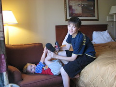
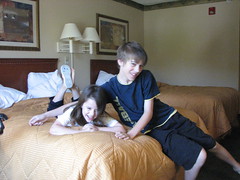
Over the last two and a half weeks,
we packed five people and too much stuff into a minivan,
drove it 3,748.1 miles through 11 states and the District of Columbia,
reconnected with dear aunts, uncles, and friends,
met a longtime e-mail and blog pal in person,
bumped into a former co-worker of my wife's,
introduced our kids to the kids of a college friend and watched them hit it off,
enjoyed unseasonably cool weather,
visited Abraham Lincoln's boyhood home and the building where he first served in public office,
ate dinner in Santa Claus (Indiana),
went kayaking in Little Assawoman Bay,
rode a narrow-gauge steam train in the mountains of Pennsylvania,
visited a railroad museum and its elaborate model layouts,
spent the day at an old-fashioned, family-owned amusement park,
went swimming and picnicking at a lake in a Pennsylvania state park,
taught a Maltese dog some new tricks,
sat on a porch and watched the rain come down,
picked zucchini, squash, cucumbers, and broccoli from the garden,
ate fresh sweet corn and tomatoes from a produce stand named Sipes (of all things),
ate zeppolis at an Italian festival in West Virginia,
used the free wifi in a tiny branch library in a tiny Pennsylvania town,
played music at the open stage night at the town's volunteer fire station,
tried exotic ice cream flavors -- chocolate marshmallow, peanut butter, bittersweet, and teaberry (which tastes just like Pepto-Bismol),
tried Pennsylvania Dutch birch beer (liked it) and Ale-8-1 (not so much),
took a guided shorebird tour,
visited an old U. S. Life Saving Station,
swam in the Atlantic Ocean,
watched dolphins at sunrise just offshore,
ate fresh crabs,
ate Herr's Old Bay flavored potato chips,
ate pastrami in a kosher restaurant in Washington,
ate salt water taffy,
managed to offset most of the eating with a lot of walking,
rode the Metro and walked between the hotel and the station,
stayed the night in a two-day-old hotel,
went tax-free shopping at an outlet mall in Delaware,
put up with abysmal internet access and cell phone reception,
looked out over one of the deepest river gorges in America,
visited the Museum of Frontier Cultures,
visited the National Air and Space Museum,
visited the National Museum of Natural History,
rode to the top of the Gateway Arch,
walked around my wife's childhood church,
saw a sand sculpture contest,
stayed in two different houses and five different hotels,
ate some truly loathsome "hot breakfasts" at said hotels,
ate the best breakfast at the tattiest and cheapest hotel on the trip,
managed not to leave behind any beloved blankets or stuffed animals,
managed to suffer only a few minor injuries (an elbow scrape, a couple of head colds, and one wrenching of the knee -- mine) and only one minor ding in the rear fender,
managed to avoid any disasters at home (except for someone not shutting the freezer door all the way),
and generally had a wonderful time,
except that now I need a vacation.
More specifics and pictures in the days to come.
There are a couple of tours happening in and around Tulsa this weekend that may tickle your fancy:
An all-day bus tour of historic all-black towns will take place this Saturday, from 7 am to 5 pm. Freed slaves from the Muscogee (Creek) Nation founded a number of towns south and east of Tulsa around the turn of the 20th century. Other towns were established in the newly opened Oklahoma Territory at the end of the 19th century as part of a black statehood movement.
The tour is $30. For information and to make reservations call 918-596-7280. (Found via TheMidtowner.)
This New York Times story is a good introduction to Oklahoma's all-black towns. Alison Zarrow has made her photoessay on Oklahoma's black towns, Wish You Were Here, available online.

This Saturday evening, 5:30 to 8:30 pm, the Modern Tulsa committee of the Tulsa Foundation for Architecture is hosting a tour of homes in the mid-century modern neighborhood of Lortondale, east of Yale Ave. between 26th and 28th Streets.
Designed and built in 1954 by Tulsa duo Donald Honn (architect) and Howard Grubb (builder), the Lortondale Neighborhood was the recipient of a multitude of national design awards. The neighborhood was featured in an array of magazines including House and Home and Better Homes and Gardens.In recent years Lortondale has experienced something of a rebirth. A new generation of homeowners, interested in modern design, are snapping up the houses just as fast as they come on the market. After decades of neglect, many of the houses in the neighborhood are being restored to their former modern glory. Most importantly, the Lortondale Community is experiencing the same restoration.
This year's tour seeks to convey the energy that is the Lortondale Neighborhood today. Featured are 6 houses in various stages of completion. From the beginning stages of a restoration to a virtually complete example of HiFi-modern bliss, this tour of Lortondale will show you what all the buzz is about.
Tickets are $10 in advance, $15 the day of the tour, and available at Dwelling Spaces, Urban Furnishings, Ida Red Boutique, and the Tulsa Foundation for Architecture office. All the details are available at the Modern Tulsa website.
The tour is self-paced. You can start at any home and purchase a ticket at the first house you visit:
- 4912 E. 26th Terrace
- 5331 E. 26th Pl.
- 5342 E. 26th Pl.
- 4953 E. 27th St.
- 4958 E. 27th St.
- 5312 E. 27th St.
There's an ongoing online tour you can follow vicariously. A family is visiting all 77 of Oklahoma's counties, taking photos, and recounting their travels. You can follow their progress on the 77 Counties blog. (The latest entries will also be linked on the BatesLine Oklahoma headlines page.)
Yesterday, while catching up on yard work, I wished that I had had a chance to look through the appropriate Federal Writers' Project guidebook prior to a recent business trip. When I have free time during a trip I try to see the unique places around me, to get away from the interstate and the suburban hotel. The older neighborhoods (Tulsans, think Cherry Street and Brookside) usually have the most interesting, locally owned restaurants and most interesting streetscapes. If I have a car, I like to figure out where the main highways into town used to run and follow them, looking for old neon and roadside architecture. The Federal Writers' Project American Guide Series books, one for each state, mostly published in the late 1930s, provide a wonderful, detailed snapshot of American travel before interstates and chains and are useful today in figuring out where the interesting local stuff can be found.
It hit me that since the original editions are out of copyright and were funded by the taxpayers anyway, the Federal Writers' Project books ought to be fully available on Google Books. That isn't fully the case yet, but many of the state books are online.
Here's an interesting snippet from North Carolina: A Guide to the Old North State, tour 28 (U. S. 70 from Durham to Atlantic):
At CROATAN, 157 m. (28 alt., 29 pop.), a FOREST FIRE TOWER (R) affords a wide view of the surrounding forest and marsh.The SELF-KICK-IN-THE-PANTS MACHINE (public invited; no questions asked), set up by Tom W. Haywood in front of his filling station in July 1937, has worn out four shoes in its service to tourists and citizens. If you feel that you deserve "a good swift kick," turn the handle; the cable will be pulled and a huge shoe laced to an iron "leg" will administer the boot.
When you come across something like that in an old guidebook, the next step is to see if it's still there.

Haywood's machine was donated to the North Carolina Museum of History, but a replica stands on the old spot. From the Fall 2008 issue of Tar Heel Junior Historian (48:1):
Ever do something so dumb that you just wanted to kick yourself?
Tom Haywood, of Croatan, knew that feeling and figured other folks might sometimes feel that way, too. So during the summer of 1937, he and local handyman Wilber Herring built a contraption that would deliver a good, swift kick to the seat of the pants of any willing recipient.
The simple machine consisted of a hand-operated crank connected by a belt and pulleys to a wheel. Four spokes, each with an old shoe attached, jutted out from the wheel. To get the boot, the operator just bent over and turned the crank.
A Craven County commissioner, Haywood said he intended the kicking machine for his personal use, "to perform the needed rebuke to my conscience." He kept it behind his house. But so many folks heard about the machine and wanted to use it that Haywood finally moved it to a shelter in front of his general store. The shelter stood at the roadside on U.S. 70, about ten miles east of New Bern.
According to old newspaper accounts, the kicking machine got a good workout on Sunday afternoons from motorists going home from the beach. But at nighttime, the machine really got cranking. "A lot of folks don't want people to know they need a kick, so they wait until I close up at night and then come around," Haywood said. "Late at night I can hear the machine just a squeaking outside."...
These days a replica of the original kicking machine stands in front of Haywood's old store, now an antiques shop. Heading east toward the coast, it's on the right side of U.S. 70 just before its intersection with Catfish Lake Road in Croatan. So if you ever feel like you need a kick, go give it a try.
This looks like it might be the home of the self-kick-in-the-pants machine.
Since I started writing for Urban Tulsa Weekly, I've had a few photos and graphics published in the paper -- Lady Belvedere, the Statehood Centennial parade in Guthrie, PLANiTULSA workshops, along with some I took to illustrate one of my columns.
But today for the first time I got to see one of my photos in a hardbound book. It's a picture of Monkey Island at Ralph Mitchell Zoo in Independence, Kansas, and it's in a brand new coffee table book called Amazing and Unusual USA by Jeff Bahr. Bahr is co-author of Weird Virginia and a contributor to several other books in the Weird series.
I took the picture in 2007. My youngest son, then about 18 months old, and I stopped in Independence on the way north to Lawrence for my uncle's 50th birthday party. I have happy memories of the park and zoo from my childhood, and I thought my little one would enjoy looking around at the animals and the playground. We might even get to ride the train.
My wife and older two weren't able to come along, and they had the nice camera, so I took a bunch of pictures with a Kodak DX7440 which had an automatic lens cover that needed an occasional nudge with a fingernail to open all the way. Most of the pictures were of my son at various nursery-rhyme-themes spots in Kiddy Land, but I took a few documentary-type shots, too, of the park and vintage playground equipment. Nothing too artistic (although this one was quite nice, I thought) but well-framed with context.
I posted the photos as a set on Flickr, and duly added descriptions, tags, and geocoding.
A little over a year later, last September, I received an e-mail from Publications International asking for permission to use the Monkey Island photo.
Today we got a box in the mail, and it was my contributor's copy of the book! I understand that it will be available to the public next month.
Amazing and Unusual USA is 320 pages, attractively laid out with large images next to informative and often humorous text, organized by region. It features many of the "World's Largest" statues from around the country. Oklahoma is represented with four photos: Ed Galloway's World's Largest Concrete Totem Pole in Foyil, Tulsa's Golden Driller, Hugh Davis's Blue Whale in Catoosa, and a couple of guys wrestling an enormous catfish at the Okie Catfish Noodling Tournament in Pauls Valley. I have a number of books about weird Americana and roadside attractions on my shelf, but I've only heard of perhaps a third of the odd attractions in the book. The kids enjoyed paging through the book and had to be shooed away when it was time for bed.
The fact that my photo is in this book is not a tribute to my photographic skills but to the power of Web 2.0. Because I had uploaded the photo and tagged it in several meaningful ways, it could be found by someone looking for just the right image of the Birthplace of Miss Able.
In last week's issue of Urban Tulsa Weekly, I urged making cultural heritage tourism the focus of Tulsa's efforts to attract visitors. Rather than marketing Tulsa as an "ocean of sophistication in a cultural desert," Tulsa should embrace its place in Oklahoma as "the capital of a region where visitors can experience the untamed, exuberant spirit of the American West in all its variety."
For whatever reason, the people we pay to promote Tulsa to the world -- the Tulsa Metro Chamber's Convention and Visitors Bureau -- seem uncomfortable promoting the unique aspects of our region. They position Tulsa as superior to and separate from the rest of Oklahoma, an oasis of sophistication in a cultural desert.It's a distinctly Midtown Money Belt point of view, and it makes Tulsans seem like a bunch of insecure, provincial rubes, putting on airs -- the urban equivalent of Hyacinth Bucket.
While we should be proud of the cultural amenities that make Tulsa a great place to live, our tourism marketing should focus on what sets our region apart from the rest of the world.
A Milanese woman who lives a few miles from La Scala and the salons of Versace and Prada isn't likely to visit Oklahoma for the opera or Utica Square shopping, but she might come here to eat a chicken fried steak on Route 66, experience Oklahoma! in an open-air theater, or attend a powwow.
A resident of Berlin wouldn't cross the pond to see a Tulsa production of the plays of Bertolt Brecht, but he might travel here to two-step across Cain's curly maple dance floor, search out Ponyboy Curtis's hangouts, or attend the annual Kenneth Hagin Campmeeting -- depending on his particular passions.
Tulsa should position itself not as an enclave of Eastern sophistication but as the capital of a region where visitors can experience the untamed, exuberant spirit of the American West in all its variety.
Read the whole thing, and read more about how other cities and regions have successfully used their history as a tourist draw at culturalheritagetourism.org.
Just found this, from Tulsa Business Journal's October 27 edition: The Max Campbell building, with its distinctive roof of multicolored clay tiles, is going to be restored as a hotel and retail space. That's the original function of this 1926, block-long building on 11th Street between Birmingham and Columbia.
Aaron Meek, owner of Group M. Investments Inc. said he plans to restore the building turning the space into a hotel with an events center and restaurant in the bottom level."It is my understanding that the building was originally a hotel on the top stories, and the bottom was used as retail space," Meek said. "We have gotten enough interest to where we are going to go back to that original purpose."
The project isn't new territory for Meek, who he said worked primarily on the restoration of older homes and properties in the mid-town area.
"We love the old buildings and love getting them back to their original state," he said. "We're working on another project down the street that we're turning into lofts.
In 1957, this building was home to a drug store, an auto parts store, a barber shop, an office supply company, and, upstairs, the Casa Loma hotel.
It's a neighborhood landmark that has been in that spot since before Route 66 was routed down 11th Street.
In the story, Meek notes how costly it is to restore a building. Hopefully, he'll think to apply for the historic register status to which the building is entitled, which would qualify him for state and federal tax credits. This restoration seems like it would also be a good candidate for the Route 66 Corridor Restoration Program. That program was used to help accomplish the restoration of the Vickery Phillips 66 station at 6th and Elgin, which is being reused as an Avis car rental location.
Unfortunately, reauthorization of the Route 66 Corridor Restoration Program is being blocked by our own Sen. Tom Coburn. Here's a link to Coburn's statement and the key excerpt:
Several tourism related measures, including a couple that have already become a favorite piggy bank to pay for congressional earmarks, such as the Save America's Treasures program, the Preserve America program, and the Route 66 Corridor Preservation program. The Route 66 program is currently restoring aging gas stations, motels and restaurants. Unfortunately, tourism has declined with many Americans unable to afford the cost of gas and, as evidenced by this bill, Congress' misplaced priorities threaten to drive up the cost of travel.
While I understand his perspective, this program is administered by the National Park Service and is in keeping with the NPS's mission of protecting the nation's heritage and making it accessible to visitors from our own country and from overseas. Interest in Route 66 has been growing (a long-term, Internet-fueled trend that has received a giant boost from Pixar's Cars), but at the same time, landmark roadside buildings continue to be lost to purposeful demolition and to demolition by neglect.
As Route 66 expert and author Emily Priddy points out, cruising the Mother Road is a very affordable vacation destination, and people looking for cheap ways to see America are rediscovering Old 66:
I don't know where Coburn is getting his information. Yes, some Americans are having trouble buying gas, and no, they're not traveling as far. But in my extensive travels on Route 66, I have met literally hundreds of small business owners. I've spoken with many of them this year. They are all in a position to know what's going on along the Mother Road -- and what's going on is that Route 66 is thriving, largely because of increases in foreign travelers (who are used to unholy gas prices); locals (when you can't afford Disneyworld or the Grand Canyon, you explore your own backyard); and bargain hunters (fuel-efficient speed limits and great values on food, lodging and entertainment make Route 66 a penny-pincher's dream).
The Route 66 Corridor Restoration Program is not an earmark. Congress appropriates money for the fund, but the NPS processes applications for the grants, which must be matched, and must go to projects that meet the NPS's standards for the treatment of historic buildings. No money has been earmarked by Congress for specific projects. Originally envisioned as a 10-year, $10 million program, only $1.2 million in federal money has been granted over the first seven fiscal years. The program ends at the end of Fiscal Year 2009. The new bill asks Congress to authorize $8 million over 10 years, starting in FY 2010.
Compare that to the $15 million allocated by Vision 2025 for the highway, which would work wonders on Tulsa's stretch of 66 if it were used as matching grant money for neon repair and building restoration. (It won't be, sadly.)
This may be one of the government's most cost-effective programs to encourage historic preservation and tourism, as the government foots less than half of the bill and doesn't have to pay for ongoing operation and maintenance of the sites that are improved.
We were driving south from Ballinger, Texas, on US 83. It was about time to stop and stretch our legs anyway, when I saw a skinny brown and white sign -- an official -looking, state-placed sign marking a recreational or historic feature -- that said "Indian pictographs." I stopped some yards further down at what I thought was a historical marker. (It was a dedication plaque for the 1930s bridge over the Concho River.) On a whim I turned around and turned in at the sign.
The road was a winding gravel ranch road which led to a small house. We passed a couple of bison along the way. My expectation was a 10-minute stop and a look at a some faint paint marks on rocks. The Paint Rock pictographs turned out to be much more.
Ranch owner Fred Campbell came out of the house to meet me. He told me about the tours, and we discussed the logistics of bringing along a 2 1/2 year old along a 1,000-foot-long trail. He offered to lead us down to the start of the trail -- we in our minivan would follow him in his small utility truck -- then I could drive the utility vehicle along the trail with the toddler on board, while the rest of the family walked along beside him. (Visions of piloting a stickshift on a bumpy, twisting trail filled me with fear, but I agreed anyway.)
The ranch, we learned, had been in his wife Kay Campbell's family since her grandfather settled there in the 1870s.
The house turned out to be a very nicely appointed visitors center. A couple of persian cats and a border collie roamed the shady yard. Inside, Fred demonstrated how the Indians used rocks like hematite to make paint, explained some of the symbols we would see and the lore behind them, and showed us a time-stamped video of "daggers" of light crossing certain pictographs on the solstices and equinoxes, indicating that the rocks were used as a kind of calendar.
Then Fred got into his utility truck with the two big kids riding shotgun, while we followed in the Odyssey. He led us through a gate, past some of his angora goats, down to a flat camping ground between the Concho River and the limestone bluff on which the pictographs appeared. The 1,000 foot trail was a level path along the base of the bluff, easy to navigate. We stopped briefly at about a dozen stations along the bluff, as Fred pointed out and explained some of the most interesting of the pictographs. The pictographs were easy to make out.
Back at the visitors' center, we paid for the tour ($6 each for adults, $3 each for children), picked out some postcards, and chatted with Fred, as we took a final pit stop before getting back on the road. (The visitors' center has very nice restrooms.)
(Fred told me an interesting story about meeting the Duke of Wellington, who invited him to his Spanish estate to discuss its suitability for raising angora goats. The Duke was affable, but his wife was standoffish as soon as she had been introduced to Mr. Campbell. On the last day of the visit, the Texan learned why -- Lady Wellington told him she was descended from Clan McDonald, which had been massacred by the Campbells of Argyll at Glencoe in 1692. For his part, Fred apologized for what happened three hundred years ago, but pointed out that he hadn't been there. Old grudges die hard over there.)
As we got into the van to leave, Fred gave the kids some small rocks of the type used to make paint. While it wasn't in our plan for the day, all five of us thought the Paint Rock Pictograph site was a very worthwhile and fascinating detour.
To arrange a tour, phone 325-732-4376, or write:
Fred and Kay Campbell
Paint Rock Excursions
Box 186
Paint Rock, TX 76866
This Google map shows directions from the town of Paint Rock ("A") to the visitor's center ("B"). The loop in the road about 1500 feet west of "B" is the at eastern end of the pictograph-covered limestone bluff (which looks like a thin white road), but you may only go there as part of a tour.
RELATED LINKS:
An American Profile article from February 2008 about the Paint Rock pictographs will give you an idea of what happens on one of their tours:
Kay Campbell, 80, walks along a dusty trail on her central Texas ranch, leading a tour group of school children. She stops along the way to point out dozens of crude drawings painted on a rock bluff overlooking a once popular American Indian campground. Ranging from a few inches to several feet in size, the rock art is the legacy of American Indian tribes that roamed the area centuries ago. Some of the drawings--animals, human figures, weapons, stars and suns--tell stories that experts can decipher, while others remain mysterious, vague communications from cultures that existed some 200 to 500 years ago....At the beginning of each tour, she scrapes hematite rock, mixes the red shavings with water, and uses this to paint symbols on her arm. A retired school teacher, she uses "show and tell" to demonstrate the process by which American Indians made the paint that they used to fill in designs etched by flint. "I try to show how people lived thousands of years ago and how they wrote history without letters or words," she says.
This brief 1999 press release by archaeastronomer R. Robert Robbins of the University of Texas explains what has been observed, with photos showing the interaction of sunlight and pictograph on the solstices.
An article on the Concho Valley Archaeological Society website tells what has been found in excavations on the plain below the decorated limestone cliffs.
Bob Anderson, a gourmet garlic grower and amateur astronomer, has written about the astronomical features of the Paint Rock pictographs. He believes some of the drawings depict the spring sky, widely-observed supernovae, and an eclipse.
This article is about visiting the pictographs on the winter solstice.
The pictographs are just across the Concho River from the town of Paint Rock, population 300, seat of Concho County.
Once is a fluke, twice is a coincidence, three times is a tradition. (So went a saying that was common around my college fraternity house.)
Two years in a row now, our minivan has suffered a flat tire as we returned home from a trip to Texas. Last year, the tread came off of our left rear tire while on the H. E. Bailey Turnpike south of Chickasha. The Wal-Mart tire store stayed open a bit later and replaced our tire for us, allowing us to make it back to Tulsa that night.
This year we were on our way back, coming up I-35 from San Antonio, where I had been on business, bringing the family along from our trip to Stamford. We stayed overnight in Denton, and the following morning my wife noticed the right rear tire had gone flat. (I was too busy congratulating myself on a good job repacking the back to notice the flat.)
While I put the temp spare on and rearranged the back of the van to accommodate the flat, my wife called tire stores. We wound up at Discount Tire, 2245 S Loop 288, just off of I-35E. The LaQuinta gave us an extra half hour in the room so the rest of the family could stay cool while I changed the tire.
Discount Tire took care of us in just over an hour, during which time we had lunch at the Burger King next door, which had a huge indoor play area. The tire had a leak, which they were able to fix. When the manager handed me my keys and my bill, I saw that the total was $0.00.
"No charge? That was a lot of time and effort for no charge."
"I'd tell you to keep us in mind when you need tires, but you're not from around here. But we'll be in Oklahoma before long."
Discount Tire is in 22 states. There are four locations "coming soon" to Oklahoma City: I-240 & Shields, Kilpatrick Tpk & Penn, 10800 N May, and 8268 NW Expressway.
The Denton location of Discount Tire deserves praise for showing kindness to travelers who were very unlikely to become customers.
I am very proud to announce that my son finished second Saturday in the 18-and-under division at the Old Timers Fiddle Contest at the 2008 Texas Cowboy Reunion in Stamford, Texas. His prize was a $50 bill, presented to him by the event's MC, former Congressman Charlie Stenholm. He performed Cotton-Eyed Joe, Tennessee Waltz, and Faded Love. I heard a number of people in the audience humming along on that last number. He has only been playing violin for two years, and he's made great strides since last year's contest, when he placed third.
As I told him before his performance, however the contest turned out, we already know he's a much better fiddler than he was a year ago. I hope to post video later in the week. (Internet connectivity here is rather limited.) One of the senior contestants, Bonnie Workman, complimented him afterwards and encouraged him to keep going, even though he didn't win. She told him it takes heart to be a fiddler, and she could hear it in his music.
He had the novel experience of being recognized today. He was wearing a distinctive hat, which made a difference, but a couple of people stopped him when we went back for the cowboy poetry performance that afternoon -- a young man told him he was in awe of his fiddling ability. He was recognized again at a dance at Old Glory that evening. We just happened upon the event - a Czech polka band playing under an open-air pavilion to a crowd of about 50.
Abilene TV station KRBC was covering the fiddle contest and interviewed my son. Click that link to see the video.
There may not be a better place to experience old time Texas than Stamford, Texas, at the annual Texas Cowboy Reunion.
Check the traffic before you get on the highway with the Oklahoma Department of Transportation (ODOT) traffic camera website, Oklahoma Pathfinder (oktraffic.org).
Tulsa has cameras at major freeway junctions: I-44 and the Broken Arrow expressway, BA & US 169, I-44 & I-244 (west side and east side), I-44 & 169, I-244 & 169, southeast and southwest interchanges of the Inner Dispersal Loop, plus 71st St & 169, I-244 at 25th Street on the west side, the BA at 129th East Ave, and I-44 at Elwood. The camera locations are displayed on a map; you select a location, then select which of two to four directions you want to see. This will be very helpful for routing around snarls, particularly at locations like eastbound I-244 at I-44, where a severe backup can catch you after there's no way to get around it.
A collection of links to the free wi-fi establishments I've visited while traveling, to be updated from time to time:
Community Bakery, Little Rock, Arkansas
Stardust Video and Coffee, Orlando, Florida
Austin Coffee and Film, Orlando, Florida
Boba Cafe and Deli, City Market, Savannah, Georgia
Mosaics on Main, Belleville, Illinois
Cairdeas Coffee, St. Louis, Missouri
La Gra Italian Tapas, St. Louis, Missouri
The Coffee House Club, St. Louis, Missouri
Meshuggah Coffee House, University City, Missouri
La Tazza Fresca, Austin, Texas
Wrapid, York, England (no longer open?)
Cross Keys pub, Dringhouses, York, England (wi-fi via The Cloud -- not free)
Iso-Bar, Leith, Edinburgh, Scotland
The Jolly Judge, Edinburgh, Scotland
I think they've upped the sensitivity on the scanners at Tulsa International Airport.
I tripped the alarm with the following metal on or about my person:
- My wire-rimmed glasses (titanium alloy)
- My gold wedding band
- My wrist watch
- A pair of jeans with two small metal rivets, a metal zipper, and a metal fly button
- A small belt buckle
- A small nail clipper
- A penny
- A paper clip
In the past, I've gone through with no problem with everything except the last three items. It's possible that a nail clipper, a penny, and a paper clip were just enough more to put me over the threshold, but I doubt it somehow.
When I tripped the alarm the first time, the TSA agent waiting on the other side sent me back and told me to check my pockets. I found the nail clipper and showed it to him, then started to look for a little bin to send it through the X-ray. At most one or two people were waiting behind me. He said, "That should be OK," and waved me back through with the clipper still in my hand. I set off the alarm again, and the agent said, "Two tries are all you get. Step this way, please." And he shunted me to the area where you wait to be wanded, which was already backed up.
I got the distinct impression that the TSA agent was playing a little bureaucratic game. By rushing me and others through, without giving us time after the first beep to rid ourselves of the least bit of metal, he was able to keep his line moving and make himself look efficient, while making his colleagues in the wanding area look like they couldn't keep up.
I could have misjudged the man, however, and I was especially annoyed because a meeting at work delayed me getting to the airport, and I was close to missing my flight. Still, if you're flying out of Tulsa, you may want to be more thorough than usual about stripping off anything with the least bit of metal on it.
Three summers ago, our family enjoyed a few peaceful days with some of my wife's relatives, staying in their beautifully restored and decorated home, built in 1913, in Little Rock's Quapaw Quarter. It looked like it ought to be a bed and breakfast, and now it is. (Here are some pictures of our kids at the house.)
Robinwood B&B has a website -- still under construction, but you can view pictures of several of the rooms and find their phone number, so you can call and speak to innkeeper Karen Ford or her mom Miriam to learn more. The website notes that the B&B is pet-friendly, something of a rarity. (UPDATE 2008/03/31: They've posted their room rates and booking policies.)
Little Rock is about a four-hour drive from Tulsa, and Robinwood B&B would make a great getaway.
RELATED: Just a few blocks away is the wonderful Community Bakery, on Main Street, just south of I-630, a local gathering place that I used as an office during our trip three years ago. From a blog entry I started at the time, but never finished: "This was my main office during our visit to the city, and I paid rent in the form of purchases of delicious treats like peanut butter cookies, brownies, bagels, a grilled chicken sandwich, a spinach frittata, and excellent coffee. The Wi-Fi connection was excellent, and there were enough outlets scattered around for the laptop users. A CD of baroque music played in the background. They have a small collection of board games and a stack of today's newspapers for the perusal of customers. There are nice views out onto Main Street, outdoor seating in good weather, and plenty of free parking."
FlightGlobal.com reports that American Airlines is looking for a 150-seat narrowbody aircraft to replace its fleet of MD-80s and 757s. The engines for this new short-haul fleet will need to make less noise, consume less fuel, and produce a lower volume of emissions. CFM (the GE / Snecma joint venture) and Rolls Royce are considering open-rotor technology for their next generation jet engines. Instead of the fan blades being inside a cowling, they'd be exposed. (Here's a photo of an open-rotor engine.)
This technology, and the promise that this could give a 25% to 30% improvement in efficiency, "seems to be really a paradigm shift in fuel consumption", says [American Airlines executive VP of operations Bob Reding].He notes, however, that questions still need to be answered concerning the maximum cruise speed that aircraft can fly with open rotors, the noise characteristics and certification requirements.
"There will probably be some blade-out requirements," says Reding, adding that since certification requirements are not yet written "that is certainly one of the unknowns and certainly one of the issues that will have to be addressed".
By "blade-out" I think he means, "What happens if a rotor blade breaks off and goes spinning through the air like a ninja's throwing star?" Given that the United Air Lines DC-10 Sioux City crash was caused by fan blades from a cowled engine severing the hydraulic lines to the control surfaces, that could be an important thing to test.
AT&T has announced a deal that with Starbucks that will, among other things, give AT&T broadband subscribers access to free Wi-Fi at the coffee chain's 7,000 company-owned US locations. That's in addition to AT&T basic Wi-Fi access already available at McDonald's and Barnes and Noble Bookstores. The switch-over from Starbucks' current provider will take the remainder of 2008. Having to pay for Wi-Fi is one of the reasons I avoid Starbucks in favor of locally-owned coffee houses. (Better coffee, later hours, a more interesting clientele, and not doing evil things like threatening a local coffee company over use of a generic term like Double Shot are other reasons I like local better.)
In order for an AT&T DSL subscriber to qualify for free basic AT&T Wi-Fi, you have to subscribe to at least the Express level of service (1.5 Mbps download). Check your bill: I started back when unlimited access to AT&T Wi-Fi (then called FreedomLink) was an extra $1.99 a month. They're still charging me for it, but they shouldn't, since I qualify for free access.
It'll be nice to have more Wi-Fi connections available in a pinch, but I expect I'll still make places like Coffee House on Cherry Street, Shades of Brown, Double Shot, and Cafe de El Salvador my caffeinated, wireless homes away from home.
From the Wikipedia entry on Kissimmee, Florida:
The Houston Astros conduct spring training in Kissimmee, at Osceola County Stadium. The Astros' farm system formerly included a Kissimmee entry in the Florida State League. In order to prevent jokes, the team's nickname was the Cobras rather than the Astros.
One evening after all the meetings were over, I decided to visit two towns, one old, one new, south of Orlando's main tourist district.
First stop was Kissimmee. Most people who have been there know the town for US 192, Irlo Bronson Way, a busy strip of tourist businesses that lead to the Maingate area of Walt Disney World. But south of 192 there's an actual town, the county seat of Osceola County, with a main street (Broadway), a courthouse square, an Amtrak station, and a lakefront.
When I was searching for Wi-Fi locations before my trip, I learned that the Kissimmee Utility Authority had established a free Wi-Fi zone in their downtown, so I was curious to see how it was working.
Although Kissimmee's Broadway has some handsome old buildings, plus some new mixed residential and retail buildings being constructed in a classic urban fashion, they all seem to house businesses that are open only in the daytime: banks, real estate offices, a photographer, a guitar store, a Christian book store, antique shops, a bakery, a couple of cafes. Only one restaurant was open, just off of Broadway. I don't imagine a free Wi-Fi zone helps boost downtown business much if the only place to use it is sitting on the curb or behind the wheel of your car. Just to test it out, I did try to connect from inside the minivan, found several of KUA's access points, but none of them strong enough to hold a signal.
The most interesting sight in old Kissimmee is the Monument of States. It has a homemade quality to it that reminds me of Ed Galloway's work near Foyil. It is a 50 foot high pyramid-like structure with rocks from every state embedded in painted concrete, and it dates back to World War II, a project of the Kissimmee All-States Tourist Club. The rock from Oklahoma was a polished slab (quartz, probably) with Gov. Leon Phillips' name engraved in it. It's at the base on the north side, in the lower left of this photo, to the left of the words "MONUMENT OF STATES."
Other inscriptions on the monument appear to have been etched out of the concrete by hand. Here's a vintage postcard of the monument. Here's a fairly recent Flickr photoset. Like our beloved Blue Whale, it was refurbished a few years ago with the help of the good folks at Hampton Inn.
I left Kissimmee and headed to Celebration; more about that in a later entry.
When I was booking my trip to Orlando, I was excited to learn that Thrifty not only had a great weekly rate, but a special deal called "Wild Car." For less than the cost of booking a mid-size, I was guaranteed a mid-size or better. Maybe I'd wind up with an SUV with satellite radio or a sporty ragtop. It worked out to about $80, or $120 once all the taxes and fees were figured in.
I like to book Dollar or Thrifty when I can. The prices are usually good, I've always had good customer service, even when renting from a Dollar affiliate overseas, and I like supporting a local company.
The way the Wild Car works, I learned from the agent in Orlando, is that every Wild Car customer on a given day gets the same type vehicle.
The day before I arrived, the Wild Car was a PT Cruiser.
The day before that, it was a convertible.
The day I arrived, it was a minivan. Chrysler Town and Country.
Wooo.
Monty Hall would call that a zonk.
Now if a customer really needed a minivan, they'd probably have booked one. If you didn't need one, I can't imagine you'd think a minivan is better than a mid-size.
Something to keep in mind when you're thinking about rolling the dice on that Wild Car deal.
I spent the summer of 1982 in Ocean City, New Jersey, a beach resort 12 miles or so south of Atlantic City, as part of a Campus Crusade for Christ summer project with about 50 other college students. We spent our days working -- I was one of several who commuted to Atlantic City to work in a souvenir shop on the Boardwalk called Rainbow's End. It was one of nine or so in a chain run by a man named Ed Devlin, III, out of the flagship store, Irene's, in Ocean City. Most of the time, I was either inside trying to sell guilty gamblers some cheap inflatable airplanes to take home to their neglected children or out on the boardwalk making sure no one ran away with our selection of 99-cent cassettes and two-for-a-dollar LPs as the Ms. Pac-Man theme blared from the arcade next door. (The store was on the ground floor of what was then the steel skeleton that was intended to be the never-completed Penthouse Casino Resort and which ultimately became the Trump Plaza.)
(I spent two weeks trying unsuccessfully to find a job like the one I'd had the summer before, being paid to write computer programs. In 1982, no one in Ocean City seemed to have a computer that needed programming.)
But Ocean City itself was a delightful and relatively quiet beach resort. Intended as a resort for Methodists, it was a dry town that shut down on Sundays.
One of the things I took away from that summer was a new word: Shoobie. Ocean City had long been a popular summer getaway for Philadelphians and other tourists, who were dubbed "shoobies" by the locals. A recent article on the American Heritage website about Wildwood (another, wilder resort town further downshore) explains the origin of the term:
In Wildwood the locals have a term for tourists, shoobies. Derived from the habit of day-trippers' bringing their lunches to the shore in shoeboxes, a practice that probably started in 1889 when the Pennsylvania Railroad began running dollar excursions from Philadelphia, the epithet retains the behind-your-back scorn that distinguishes the love-hate relationship between any tourist town and its prey. (A teenage Wildwood native, ignorant of the etymology of the word but deeply familiar with its connotations, told me it came from the horrible habit of tourists wearing shoes on the beach. "That," she said, "is a very shoobie thing to do.")Considering that the year-round population of the town numbers just 5,400, the shoobies, who swell the island's population to 250,000 during the height of summer, have always been the economic reason for Wildwood's existence. Originally a dense forest of tangled trees, Wildwood began its transformation from a wild wood to a smooth landscape of motels and sand in the 1880s. Local working-class and middle-class Philadelphians and neighboring New Jersey residents were drawn by the proximity and affordability, and soon the town was a popular destination. In 1927 more than 20,000 day-trippers came to visit the island over the course of just a few days. But these early shoobies were not well loved by local merchants. The thrifty shoebox-toting visitors were not staying in hotels or eating in restaurants, and, scandalously, they changed into their bathing suits in their cars, before dumping their picnic lunches all over the sand.
The article goes on to talk about the rise and decline of the seaside motel -- being replaced by condos -- and the demographic changes in the workforce that arrives to handle the summer crowds -- once blacks from the Deep South, now Eastern Europeans.
I hope that, just as Cape May has tried to preserve its Victorian seaside resort heritage, Wildwood will wake up and see the value and appeal of its mid-20th-century motels, cafes, and seaside amusements before they're all gone.
(Via Addled Writer, who went to Wildwood last month and took some pictures.)
UPDATE 2015/07/28: Corrected the above reference to Ed Devlin. Edward Aloysius Devlin Jr. was the owner of the original Irene's souvenir shop in Atlantic City, and who made headlines in 2010 because, in his teens, Ed Jr. worked for Enoch "Nucky" Johnson, the boss of Atlantic City and the basis for Steve Buscemi's character in the HBO series Boardwalk Empire. My boss was his son, Edward A. Devlin III, the owner of Ocean Sales Co., which included Irene's and other stores in Ocean City, Rainbow's End in Atlantic City, and stores in Wildwood. In 1985, Ed III filed suit trying to overturn Ocean City's strict Sunday closing ordinance on the grounds that it conflicted with state law; the State Supreme Court upheld the city's ordinance.
What brought all this to mind? With Donald Trump much in the news, I thought of Vera Coking, the woman who refused to sell her three-story boarding house, first to Bob Guccione and later to Donald Trump. Guccione built the steel frame of his planned casino building around her property and two other holdouts, including Sabatini's Restaurant on the corner of Columbia Pl and Pacific Ave. In 1993, Trump demolished the rusty steel frame (and damaged Coking's place in the process) for surface parking, and converted the old Holiday Inn tower into the east tower of the Trump Plaza hotel. Trump tried to use eminent domain to force Coking to sell, but Coking, represented by the Institute for Justice, beat Trump in court. In 2010, Coking decided to move west to be nearer her family, and last summer the property was sold at auction for $583,000, and then was demolished in November 2014 -- some 35 years after it was first targeted.
This may look like a souvenir from my recent trip to Britain with my 10-year-old for the Tulsa Boy Singers choir tour, but it's not, although the trip reawakened an interest in it.
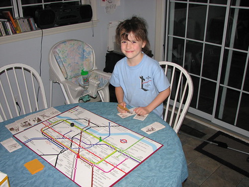
This is The London Game, a strategy game based on a map of the London Underground. The object is to be the first to travel to six tourist destinations and return to your starting point at one of London's main railway stations. There are "hazard" cards that either delay you or allow you to delay another player. Each "souvenir" card has a drawing and a description of the point of interest and the name of the nearest Tube station.
I remember playing this game with a friend of mine when we were probably 10 or 11. His family subsequently put it in a garage sale or otherwise disposed of it. I had always thought it would be a fun board game to have.
Three times in the past I've been to the London Transport Museum gift shop in Covent Garden, and three times I've balked at paying the asking price, not to mention wondering if I had room and sufficient spare weight in my luggage for the box. Last month, the museum shop had a special edition in a metal box for the low, low price of 25 pounds sterling -- about $50, and too dear for me. Once back home, I checked eBay and found a copy of the 1972 edition. I was the only bidder and price and shipping combined came to $15.
While my wife and our 10-year-old went to hear Weird Al Yankovic in concert last Friday, and after I put the 18-month-old to bed, the six-year-old and I played the game a couple of times. We opted not to use the station blocking rule and instead concentrated on getting familiar with where everything is on the board and how the basic rules work.
We added a rule that you have to say the name of each station as you pass through it. I figure it'll help the kids learn to pronounce Gloucester, Leicester, and Tottenham correctly and how to interpret a map and plan a route, and we'll all build a mental map of London which will come in handy when we go back as a family someday. There have been a few changes to the Tube map since 1972, but not many to the central London section that makes up the game board.
We had fun playing it, and we each won a round. I'll have to try the more cut-throat version, where you can block stations to delay your opponents, with the 10-year-old.
One of my earliest blog entries was about a brief visit four years ago to Riverside Park in Independence, Kansas, on the way home from seeing my cousin graduate from Lawrence High School.
Last Saturday, my uncle was celebrating his 50th birthday, so I drove myself and the toddler north, stopping in Riverside Park for a couple of hours on the way up. (There were also the requisite Sonic stops -- three in all.) We spent some time looking at the animals in the Ralph Mitchell Zoo (did you know porcupines could climb?), letting the toddler explore Kiddy Land, a nursery-rhyme themed playground created by the local Lions Club, walking through the big kids' playground, admiring the statue of a corythosaurus (a bit of Forgotten New York from the 1964 World's Fair), riding the carousel (still just a nickel) and the train (only a quarter), and envying the crowds cooling off at the city's water park.
In that earlier entry, I described in detail the wonderful old-fashioned playground equipment, much of it bearing the FUN-FUL brand. These are playground pieces you don't see in parks anymore for fear of litigation. This time I took photos and posted them on Flickr.
I should note that it was a pleasant surprise that we were able to ride the train and carousel. That was the last Saturday afternoon for the carousel and train to be running; the weather is getting too hot. I believe they still will run on Sunday afternoons, but the rest of the week only from 6:30 to 9:30.
Our route took us through the area along the Oklahoma-Kansas border that was so badly flooded only a week ago. Johnstone Park in Bartlesville was closed, but people were at work in the Bartlesville Playground (the Kiddie Park) getting it cleaned up. (The park was not yet open for business.) Highway 123 between Bartlesville and Dewey is flood-prone; the old KWON studios were built on stilts. A big tent, the kind used for outdoor sales or wedding receptions, was set up in front of the old radio station, and the stain from the flood reached at least two feet higher than where the roof met the sides -- probably 10 feet above the ground. Mud stains on the trees lining the highway told the same story.
Further north in Kansas, we could see where flood waters had matted down corn fields. The east side of Coffeyville, which we passed through on the way home, nearest the Verdigris River, was like a ghost town. Only the lights along the main road were lit; all other buildings were dark, and the flood stain reached five or six feet up the sides of the buildings.
We also took a detour into Chanute on the way home, in search of a place to buy gas and rest for a minute or two. I was surprised to see how lively the downtown was at about 11:00 p.m. The center of activity seemed to be Fire Escape, a spacious and inviting Christian coffee house on Main Street. (Had I not had a sleepy toddler, I'd have dropped in.)
Some years ago, the Kansas highway department rerouted US 169 to bypass most towns between Coffeyville and Kansas City. They did such a good job, it's often hard to know when you're passing a town. Chanute signed its own business route to help travelers find their way off the main road, through town, and back to the highway.
The toddler slept for the first half of the trip home, but he stayed awake after we stopped. We listened to Bob Wills, and I passed him back his water cup, Pringles, and rolls that my uncle sent home with us.
I'm going to repeat a question I asked after our drive through Kansas four years ago:
I am a proud Oklahoman, and yet I can't help but notice a quality and pride in these Kansas towns that I don't see in towns of similar size in Oklahoma. These Kansas towns seem to be surviving and thriving, while many similar towns in Oklahoma are on the wane, with Main Streets falling into disrepair, storefronts vacant or filled with sub-optimal uses and public spaces showing signs of neglect. The pride I've observed in Kansas I've also seen in many parts of Texas, Missouri, Iowa, Minnesota, Arkansas, and Illinois. What accounts for the difference?
What do you think?
MORE: FUN-FUL playground equipment was made by General Playground Equipment, Inc. of Kokomo, Indiana, a successor to the Hill-Standard Company of 116 Fun-Ful Avenue, Anderson, Indiana. Here's the story of one man's effort to save a spiral slide in Burlington, Iowa, that was made by the company and which had been installed in the 1920s.
Ron of Route 66 News evaluates one of Lady Bird Johnson's legacies:
But the Highway Beautification Act of 1965, which restricted billboards along our nation’s highways, proved to be damaging to Route 66 businesses when they were struggling to survive amid the continuing rise of the interstates.These Mother Road businesses were struggling enough against the chains. Restricting the use of billboards — a crucial advertising tool — made it harder....
[R]ich and powerful companies managed to skirt the law, while many mom-and-pop businesses didn’t have the influence to so.
From family trips back in the early '70s, I remember the stark difference between driving the Turner and Will Rogers Turnpikes and the Indian Nations Turnpike. The Turner and Will Rogers were built in the '50s and had many signs (evidently grandfathered) pointing to nearby Route 66 businesses like the Thurman Motel, Buffalo Ranch, and the Lincoln Motel, along with the requisite notice to save your appetite for a free 72 oz. steak dinner in Amarillo.
The Indian Nations Turnpike, built after Ladybird's Law, had no signs. This meant there was nothing to entice a passing traveler to venture off the highway, no indication that, for example, the McAlester exit could lead him to a land of hearty Okie-style Italian food. A traveler wouldn't know anything about available service stations or accommodations that might be just a few hundred yards away from the turnpike.
For kids, the Highway Beautification Act meant no practical way to play the Alphabet Game.
At some point, states began posting official exit services signs, with little logos to notify the traveler of available restaurants, gas stations, and motels. Of course, this favored the chains as well: An out-of-state motorist would know exactly what to expect from seeing a McDonald's or Cracker Barrel logo, but a logo isn't enough for a local cafe to tell you about its chicken fried steaks and pies.
(Then there was the case of the Okie Gal Restaurant in California, which wasn't even allowed space on the exit services sign because the highway department deemed "Okie" a derogatory term.)
Ron praises Lady Bird's work on behalf of wildflowers, as does Joshua Trevino, writing at National Review Online. You could see the wildflower and anti-sign initiatives as consistent, both favoring the natural over the man-made, but there is also something contradictory about them: Wildflowers are a kind of rebellion of local color against the monotony and standardization of a perfectly green, perfectly manicured right-of-way. But ads along the highway are also a splash of local color, a hint about the distinctive qualities of the next town and the people who live there.
Marvin Olasky mentions in passing another example of the damage caused by "beautifiers":
Coney Island, part of New York City, is famous in American literature and film. In "The Great Gatsby," Gatsby invites Nick to go to Coney Island, and in Clara Bow's 1927 silent film "It," the neighborhood's amusement park is practically a co-star. After 1950, though, waves of officials such as New York City Parks Commissioner Robert Moses looked down on the "tawdry" amusements that characterized the boardwalk area. They pulled strings to substitute tawdry housing projects that became gang havens.Coney Island went through bad decades, but even bureaucrats can't take away the ocean, and the beachfront location has inspired some entrepreneurs to ignore planners' sandcastles and attempt to develop new small businesses and privately owned housing.
Tulsa has had its share of destructive "beautifiers": The barrenness of the Civic Center, the Williams Center, and the OSU-Tulsa campus parking lots are their legacies.
We're hearing reports of moderate to severe flooding north and east of Tulsa. If you're wondering whether you'll need an ark to complete your Fourth of July travel plans, you can ask NOAA.
The website for the Advanced Hydrological Prediction Service has a national map showing all active flood gauges and their current state. Purple means major flooding, red is moderate. Click on the national map and you'll see an area map, and you can then click on an individual gauge to see the flood level in recent days and the predicted level over the next few days. Here's the map for the Tulsa area.
The gauge for the Caney River at Bartlesville shows that the river has crested at 21.45 feet, more than 8 feet above flood stage, but is still about 6 feet shy of the record October 1986 flood. If you'd planned to visit the Kiddie Park, you might want to phone ahead.
Here's a map for NOAA's Arkansas-Red Basin River Forecast Center, which will give you a sense of the extent of flooding around Oklahoma and neighboring states. Not only is there some major flooding in southeastern Kansas and northeastern Oklahoma, but also in southwestern Oklahoma and Wichita Falls, just across the Red River in Texas.
The Oklahoma Highway Patrol posts road closings due to weather, or you can phone (405) 425-2385 or (888) 425-2385. There are a number of warnings and closings in Nowata, Craig, and Ottawa counties.
My 10-year-old son and I got back home about 11 p.m. Wednesday night from a week in the United Kingdom with the Tulsa Boy Singers tour. It was his first trip out of the US, and my first trip overseas in eight years. We had a wonderful time, and I'll tell you about the trip itself later on, but here are a few random notes, which I'll add to as the mood strikes me:
I don't know what is in bloom in England right now, but I am highly allergic to it. It didn't bother me in Scotland, but my nose and eyes got itchier the further south we went. (Grass pollen, evidently.)
Seven days in Scotland and England and we didn't need an umbrella once. It sprinkled a bit in Edinburgh, and I'm told it rained at night, but we never saw it. Meanwhile, Tulsa is getting muddier and muddier.
The dollar is at its lowest point against the pound in years -- $2 = £1 -- but prices are the same in pounds there as they are in dollars here. Fuel costs are pushing food prices higher. Petrol is just under £1 per liter, or about $8 a gallon, and most of that is tax. High fuel prices don't seem to be keeping people from driving -- the motorways were jammed with cars.
With regard to WiFi, the UK is about four years behind the US. Free WiFi is rare, and even working paid WiFi is hard to find. I spent sometime before leaving the US compiling maps of free and paid WiFi locations near our hotels. It wasn't that I planned to spend hours surfing, but I wanted to be able to upload photos to Flickr and videos to Google for the benefit of TBS families back home and to respond to e-mail. As we waited for our bags at Tulsa International, several parents came up to thank me for posting photos, as it was reassuring to see that their boys smiling and having a good time.
Hotel access typically runs at least £10 a day, or you can pay a pound for 10 minutes of access on a terminal in the lobby. Even though we stayed in three different Holiday Inns, each one had a different provider, so it was impractical to buy a week's worth of hotel access.
A few pubs and coffee houses have free WiFi, but many more are part of a network called The Cloud. I bought a week's worth of unlimited access for £11.99. I was only able to use it twice, for a couple of hours each time, at the Cross Keys pub in Dringhouses near York. Uploading speeds were slow, but it worked. I thought I'd be able to use it at the Little Chef cafe next door to the Holiday Inn outside of Oxford, but the cafe closed at ten (despite being located on a busy highway junction). I sat down on the sidewalk outside and tried to connect; I could get a signal, but the DHCP server didn't give me an IP address, so I couldn't sign in.
WiFi worked well in only one place -- Isobar on Bernard Street in Leith, Edinburgh's port town. Isobar is a tidy modern place, smoke-free (as are all Scottish pubs, and England will follow suit on July 1), and frequented by twenty-somethings. Drink prices were reasonable. It was quiet on Thursday night, and one other person was working on a laptop. The bartender pointed me to the area where I'd get the best signal. I went back on Friday night, after a failed attempt at connecting at another free WiFi pub (Stack Bar and Grill -- could connect, but couldn't get a DHCP address). Isobar was almost packed, but a found a place at a long common table and wound up next to a group of female office workers out on the town. The one sitting next to me apologized for the rowdy behavior of her coworkers, but I found it entertaining.
The Jolly Judge Pub on Lawnmarket near Edinburgh Castle had good beer, a nice traditional atmosphere, free WiFi, and a decent signal, and I might have stayed longer, but I needed to eat dinner and they only had crisps. A search for a free WiFi restaurant in the Old Town -- the Honey Pot -- was fruitless, and I later learned the restaurant was no longer in business.
The Royal National Hotel had free WiFi, but only in the lobby, and the signal was weak and intermittent.
I had a delicious lamb keema wrap at Wrapid in York, a place that offered not only free WiFi, but, unusually for the UK, free refills on fizzy drinks and coffee. The free WiFi is actually advertising-supported WiFi -- you watch a short commercial, and you get connected. Unfortunately, the website that served the commercial was down, so the sign-in web app didn't work. Flickr Uploadr was able to connect and upload at a very slow speed, but I couldn't check e-mail or the web.
UPDATE 2007/06/25: Some further notes about what worked and what didn't.
A few weeks before the trip I purchased a set of grounded plug adapters from Family on Board. These were not converters or transformers. They simply allowed you to take a dual-voltage device with a U. S. grounded plug to and plug it into a British three-prong grounded outlet. $15.95 covered three adapters, and all shipping and handling costs. They worked wonderfully with my Dell laptop AC adapter and the charger for my Palm Treo 650. (Even though my Treo didn't work as a phone over there -- CDMA instead of GSM -- I still used it as a PDA to make notes and keep track of scheduled events.)
To emphasize, these US-to-UK adapters should only be used with devices that accept inputs of at least 240 V -- there should be a label on the device, charger, etc., that indicates, volts, frequency, amperage, and wattage for input and output.
Even then, a device may fail. My Duracell rapid AA/AAA battery recharger blew a fuse -- or at any rate stopped working -- the first time I plugged it in. It professed to be dual voltage, but I suspect it drew too much current when first powered. It was a 25 W device. (The laptop, which uses 70 W, had no problems.) The slower-charging 8 W charger might have fared better, but I didn't bother to bring it along.
Thankfully, the Duracell rechargeable AA batteries performed well enough that I didn't have to buy any on the trip, even though I couldn't recharge. For the digital camera, a Canon S3 IS, I started out with two sets of 2650 mAh batteries and a set of 1800 mAh batteries, all fully charged. Each set lasted me through two days plus a bit. All three sets together got me through eight days, 900 pictures, and nearly an hour of video.
I can't say enough good things about the Canon S3 IS. The photos were wonderful. While its critics are right that, at the ISO 800 setting, images in low light are grainy, it's still wonderful to have the option of taking relatively low light photos without the need for a flash. It takes great video, too, although it wasn't always easy to hold it steady, and the audio quality is wonderful. You can see the photos for yourself, and this link will take you to a search for the videos from the TBS tour and their concerts here in Oklahoma.
A cool thing about Flickr is the ability to connect photos to a map. I've done that for most of the TBS tour photos. Zoom in to a particular city, and you'll see photos placed to the street and block.
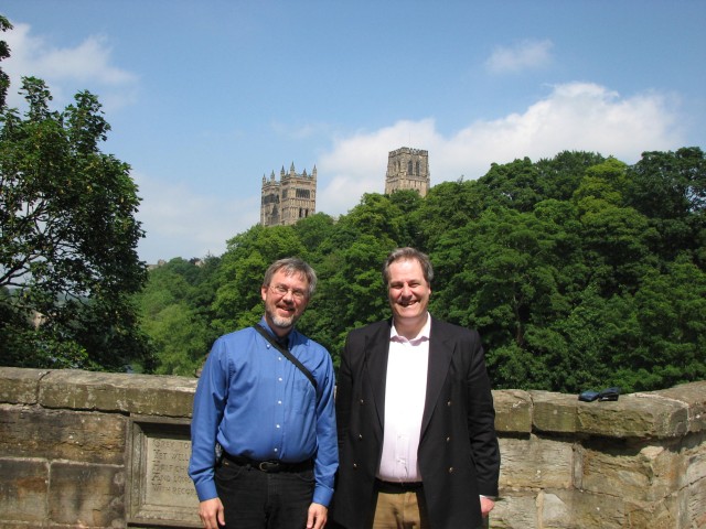
On the left, Michael D. Bates, columnist for Urban Tulsa Weekly and proprietor of batesline.com.
On the right, Michael W. Bates, former Member of Parliament and Paymaster General, now director of the Northern Board of the Conservative Party.
In the background, Durham Cathedral on a brilliant June day.
I had the pleasure of spending a lovely but all-too-brief hour and a half in the company of Michael and his son Matthew, strolling along the Wear, having a light lunch in the cathedral's Undercroft Restaurant, and talking about British and American politics and the remarkable story of the Emmanuel College in Gateshead and how high expectations can transform an underprivileged area.
I won't be able to go because of prior commitments, but this looks like a lot of fun:
The American Heritage Music Festival to be held June 7, 8 & 9 in the Grove Civic Center and Snider’s Campground will feature Hee-Haw stars LuLu Roman and Grove’s own Jana Jae.
There's a kickoff party and barbecue on Thursday, June 7 -- admission free, dinner $5 -- music contests on Friday for fiddle, dobro, banjo, mandolin, clogging, and a special competition for Bob Wills's fiddle music. The fiddle and clogging contests each have a $1,000 first prize, so it should draw some excellent competitors. Saturday night is the big finale concert.
For tickets and more information, visit http://www.grandlakefestivals.com/.
The story above came from the online home of the Grove Observer, a weekly paper. Instead of paying through the nose for a fancy website, they simply set up a blog on Blogger.com and started posting news articles. There are several other small papers in Oklahoma doing the same thing. (I've tried, and given up trying, to convince the Tulsa Beacon to set up a simple blog to post last week's stories and keep an archive.)
A group of 20 motorcyclists from England are blogging about their trip down Route 66. They began in Chicago about a week ago, and today they traveled from Rolla, Mo. to Tulsa. Everyone be on your best behavior, and make our guests feel at home!
Sometime last year, the United Kingdom Department for Transport imposed a ban on laptops and other electronic items in the aircraft cabin on flights originating in the UK. This created the absurd situation that you could carry your laptop or iPod with you in the cabin for the flight from the US to the UK but had to pack them in your checked baggage for the trip back home. At one point you could only carry your travel documents in a transparent pouch -- no handbags, nothing in your pockets.
I was thinking about this again today when I booked a domestic business flight online and found the following alert on my Travelocity itinerary page:
Travel within and from the United Kingdom:
- If you are traveling within the UK, or if you are departing the UK for another international destination, you must check ALL of your belongings. Wallets, IDs, and necessary medications are exceptions; these essential items must be carried in a plastic bag (clear bags are recommended).
- Electronic items are not permitted on board any aircraft. Electronic items include laptops, mobile phones, and iPods.
In trying to find out whether the policy is still in effect, I found plenty of comment (nearly all negative) on the ban when it was enacted, but I had a hard time finding anything indicating whether the ban is still in effect, or if there are any plans for changing the policy.
I did find this airport security page on the UK Department for Transport website, which appears to be authoritative. The rules, regarding carry-ons, electronics, and liquids seem to be only slightly more restrictive than the rules in the US. The only reference to electronics is that large items like laptops have to be removed from carry-on luggage and screened separately. No hint of a ban, and no reference to the lifting of a ban.
So were the restrictions lifted, and if so, when?
UPDATE: Here we go:
Home Office (roughly equivalent to our Justice Department) press release from August 14, 2006:
Passengers are now allowed to carry one item of cabin baggage through the airport security search point.The dimensions of this item must not exceed a maximum length of 45cm, width of 35cm and depth of 16cm (17.7"×13.7"×6.2" approx) including wheels, handles, side pockets, etc.
Other bags, such as handbags, may be carried within the single item of cabin baggage. All items carried by passengers will be screened by X-ray....
All laptops and large electrical items (eg, large hairdryer) must be removed from the bag and placed in a tray, so that when the cabin baggage is x-ray screened, these items neither obscure nor are obscured by the bag.
And this from September 21, 2006:
Starting this Friday, 22 September, larger bags will again be allowed into airplane cabins, the Department for Transport announced today.Currently, passengers boarding flights in the UK are limited to one item of carry-on luggage, with dimensions no more than 45cm by 35cm by 16cm. Starting Friday, passengers will still be allowed to carry only one item of luggage into the cabin of the aircraft, but it can be bigger, as limits are being raised to 56cm by 45cm by 25cm (including wheels, handles and side pockets).
It's odd that I can't find any reference to the changes in the press release section of the DfT website.
As I write this -- this is being posted on a delay -- I am sitting in the Albuquerque airport. Not only do they have free wi-fi here, but there is an upstairs lounge (with power outlets!) near gate B1 with views of the airfield and the mountains to the east of town.
This was my first visit to the Duke City (where the minor league baseball team is no longer the Dukes, but the Isotopes). I'm impressed. It was a business trip, so I didn't have a lot of time to explore, but we got out a little bit.
We had pizza at Il Vicino in the Nob Hill district, a lively area of restaurants, little shops, and old motels on Central -- old 66 -- just east of the University of New Mexico campus. The next night we headed north of town to a hacienda-style restaurant called El Pinto. It's on Fourth Street, the pre-1937 alignment of US 66 that passed through Santa Fe and came into Albuquerque from the north. It's in a picturesque setting not far from the Rio Grande. The restaurant, with its various rooms and courtyards, made me think of a more authentic version of Casa Bonita with better food. Even though we were in the most unattractive room in the restaurant and had an inexperienced waiter, I had a great meal of carne adobada (roast pork marinated in red chiles) with fresh guacamole. I substituted calabacitas (summer squash, zucchini, corn, onions, and green chiles) for the pinto beans. (Taco Cabana used to offer calabacitas -- I miss that.)
I saw a little bit of Route 66. Albuquerque's stretch of the Mother Road has one of the better assortments of classic old motels, and the section of Central that passes through downtown is a lively entertainment district. I'd love to come back and explore further some day.
One of the highlights of a July 2004 trip to Texas was an unexpected late-night excursion to a renowned San Antonio coffehouse and restaurant. We had stayed at Sea World until near closing, having spent most of our second day there at the water park. The kids wanted ice cream, and I promised we'd stop somewhere on the way back to the hotel downtown.
Only we didn't find anywhere on the way back to the hotel. No Braum's or Baskin-Robbins, no Village Inn or Denny's, and no frozen custard stand.
Then I remembered a place I'd driven past on a late-night grocery run a couple of days before. Even though it was after 10, it was still open. The place had beautiful mid-century neon, and it sat at a bend in the old highway like a lighthouse on a point.
(Flickr photo by bravophoto.)
So we headed north from downtown and made our way into Earl Abel's Restaurant. The interior was dark and woody. There was the requisite counter, behind which stood the lighted pie case and the kitchen window. It seemed like a bit of late '50s Hollywood had been plopped down in the middle of Texas.
We ordered pie and chocolate cake and ice cream. The ice cream was served in tall metal parfait cups with long spoons. My daughter, then not quite four, exhausted from a day in the sun and water, and a bit chilled by the air conditioning, fell asleep in her mom's arms. My son, then almost eight, had a fun chat with our waiter, who was a middle school science teacher working there while taking summer graduate school classes nearby. He had a special interest in insects.
That was one of our favorite memories from our trip, so I was sad to learn that the place was to be demolished for a condominium. That happened last summer.
But the neon was saved, and a new Earl Abel's is now open on Austin Highway in San Antonio. New ownership, but the same cool decor and the same recipes. Here's a link to a sketch of the new restaurant, and here's a picture of the neon from the side of the old building now mounted on the new site.
(Flickr photo by copazetic.)
I hope they make a go of it.
Here's a flickr search that will turn up a bunch of photos of Earl Abel's, both old and new.
I went to Arlington, Texas, today for what turned out to be two hours' worth of meetings. It was a thirteen-hour trip all told.
Anytime I have to go to the DFW Metroplex, I consider whether it's going to be faster to fly or drive. Sure, it's only a 45 minute flight from TUL to DFW or DAL, but for an accurate comparison, you have to include the drive to the airport, parking at Fine, shuttle to the terminal, early arrival for check-in and security, waiting for baggage, waiting for the rental car shuttle, waiting to pick up the rental car, and then the travel time to the final destination. Then there's the flight schedule -- unlike a personal car, you can't leave on a commercial flight anytime you want.
Today it took me four hours to get from my son's school in south Tulsa to my destination in Arlington. I only arrived an hour before my flight. If I had obeyed the instructions on my boarding pass, I would have been there three hours in advance. The biggest delay was having to go to DFW's remote terminal parking.
It took me four and a half hours to get home, from the time I started out for the airport until the time I pulled into my driveway. Because I didn't know when the meetings would end, I booked a 7:30 flight to give me plenty of time to get to DFW and get through all the pre-flight nonsense. If I had left for Tulsa as soon as my meeting was over, I would have been home an hour earlier than I was.
This was a day trip, so I saved a half-hour each direction by not checking a bag. Originally, I was supposed to be picked up and dropped off, which would have tipped the scales overwhelmingly in favor of flying -- two hours saved not dealing with a rental car.
I haven't even added in the hassle factor of flying, and the pleasure of being able to turn off the Interstate, travel the old road for a few miles, and stop at a small town cafe.
Arlington is one of the few places in the Metroplex where flying is almost always quicker than driving, because of its propinquity to DFW and the lack of a sufficiently direct route from the north. No matter which way you go to Arlington, you have to go through half the Metroplex to get there. It's definitely quicker to drive to Plano than to fly and drive, since its on the side of the Metroplex closest to Tulsa. But it's almost as fast to drive to Ft. Worth, even though it's farther, because it's interstate all the way -- higher speed limits and no need to slow down for Stringtown.
The building where the meeting was has a good view of Six Flags over Texas. I told someone that it was strange to see the place in the grownup context of a business meeting, when I remember going there as a kid 37 years ago. The "skyline" of Six Flags has changed -- lots of roller coasters and drop rides -- but the big orange derrick is still there, albeit without the giant slide that I remember from '69 and '73. (Here's a collection of Six Flags maps from the past, plus a map of Seven Seas, the marine wildlife theme park that was where the Wyndham Hotel is now. We went to Seven Seas on our '73 trip.)
There were cranes in the air -- the new Cowboys stadium is going up, near Collins and Randol Mill Road -- being built by Manhattan Construction. I would love to see some aerial photos of the Six Flags / Arlington Stadium / Ballpark at Arlington area and how it evolved over the last forty-five years, since Six Flags' debut in 1961.
I will stop my rambling there. I'm on 1170 KFAQ tomorrow from 6 to 7 as usual.
My wife's dad's folks are all cotton farmers from west Texas, specifically the area around Stamford, which is just a bit north of Abilene. We drove down and spent fall break there. What follows are some disjointed notes from the trip down and back:
We stopped at the Rock Cafe in Stroud on the way down. It was supposed to be for breakfast, as an incentive for the kids to get up and around early. But then a stray dog, a beautiful and friendly young chocolate labrador, strolled up while I was packing the car. We spent the next couple of hours trying to see if he belonged to anyone in the neighborhood, and called the Humane Society and area vets trying to figure out the best way to get him back to his owner. We finally took him to the animal shelter, figuring the owner would be most likely to look there first. The dog had no collar, no tag, no ID chip. He was not neutered. He was healthy, and although he was thirsty he wasn't hungry, so we figure he can't have come far. We posted a few signs around the neighborhood, and I posted to a couple of Internet pet lost-and-found sites.
But back to the Rock Cafe: We had lunch there. We sat at the counter, and Dawn, the owner, and the inspiration for Sally in the movie Cars, told the kids about the real-life incidents involving the cafe that inspired some of the scenes in the movie. (The DVD is out November 6, by the way!) Everyone enjoyed their lunch. I had the prettiest patty melt I've ever seen -- on marble rye -- with a side of tabouli. Delicious!
Further down the road, we stopped at a Dairy Queen south of Wichita Falls, Texas. You know you're in a small west Texas town when there's a sign on the Dairy Queen that says they'll be open late after home games. Or when the Dairy Queen has the only banquet/meeting room in town.
I liked the way this DQ does kids' meals. They're served in a sack with a coupon for a free DQ treat (Dilly Bar, ice cream sandwich, or ice cream cone). When the kids are done with their real food, they can go back to the counter to pick out their dessert. It's an incentive to finish supper, there's no cheap little toy to deal with, and dessert doesn't melt while they're eating their meal.
Also, the chicken fingers come with cream gravy for dipping.
I had a pepper-pepper burger: It had jalapeno bacon, pepper jack cheese, and chipotle sauce on it. The menu said it was a local favorite.
Favorite high school mascot name spotted on this trip: The Munday Moguls. (Will Bill Gates, Steve Jobs, Warren Buffett, etc., sue the school to change the nickname to something less derogatory?)
Normally when I travel I have no worries about finding a high-speed Internet connection. If the hotel doesn't have it, there'll be a Panera or a local coffeehouse with a free wi-fi connection, or at least a McDonald's (AT&T DSL subscribers can have unlimited use of Wayport hotspots for a tiny monthly fee). I was working on a project and was going to need to upload some large files while we were in Texas, but none of the usual alternatives were available, and we were staying with family who didn't have a computer, much less broadband. My best option looked like driving an hour each way to Abilene. As we were passing through some small towns on our way south, I noticed several motels advertising free high-speed Internet. I made some phone calls and sure enough, the two motels in Stamford both had free wi-fi for guests, although it wasn't advertised on their signboards. Problem solved. $40 (the price of a room with tax at the Deluxe Inn) is a bit steep for a day of wi-fi but it was the cheapest alternative.
I heard several mentions of wind farms in the works for the area, which sits about 1500' above sea level. Folks I talked to didn't think wind turbines in a river valley at 600' elevation was likely to work very well.
You think water is expensive? One relative, who gets city water out in the country, told us they pay $50 a month for the first thousand gallons of water. In Tulsa, that pays for 5,000 gallons, plus sewer, plus trash pickup, plus stormwater fees. Another relative has installed rainwater tanks with a 20,000 gallon capacity, and they collect "gray water" (drainage from sinks and showers) for use in the yard.
US 277 was once paralleled by the Texas Central Railroad, but sometime during the mid '90s the rails were pulled up and the viaducts demolished. You can still see the track bed, usually elevated several feet above the surrounding terrain, and the supports for bridges. Occasionally you'll see piles of railroad ties or lonely old telephone poles (the kind that look like Orthodox crosses). The old track bed and right of way is being reused to turn 277 into a four lane divided highway, and most of the towns between Wichita Falls and Abilene are to be bypassed.
Oddly, US 277 used to bypass Wichita Falls, but now it runs along the western edge of downtown and then west along Kell Boulevard. In the downtown section, they've cantilevered new expressway lanes above existing streets, minimizing the amount of demolition they had to do. The new lanes aren't open yet, and I would still expect to see a certain amount of decay from being in the shadow of the freeway, but I give them credit for trying to provide the highway without dividing their downtown from the surrounding neighborhoods.
My wife's relatives remember going to a hangar dance at the local airport back in the '40s, featuring Bob Wills and His Texas Playboys. More often, though, they'd have house dances -- they'd move the furniture to the walls and roll up the linoleum. A couple of folks would sit in the corner and play fiddle and guitar, and people would dance as best they could in the limited space available. Or they'd go to all-night parties at the Sons of Hermann Lodge in Old Glory -- play games, eat, dance until the wee hours, then roll out their bedrolls and sleep in the hall. (My wife's aunt and uncle preferred to sleep in the camper on their pickup, so the pranksters at these events couldn't get to them.)
Speaking of the Old Glory lodge, next Saturday is the big event of the season -- a sausage supper and dance. Wish we could have been around for that.
Old Glory was originally called Brandenburg, but they changed the name during World War I.
It wasn't until 1961 that my wife's relatives went to mechanized cotton harvesting. Until then, working cotton meant going out and picking it by hand.
Most family get-togethers feature cards or dominoes. Saturday night we played a game of Chicken Foot, a domino game that moves pretty quickly, as about half of your moves are tightly constrained. Each hand begins with a double (in sequence starting with double-nines) and the first eight plays must be off of that initial double, creating eight radial lines from the middle. Subsequent doubles are laid perpendicular to the line of play, and the next three plays have to be off of that double. Double blank counts 50 points if you still have it at the end of the hand.
On the way home, we stopped for lunch at a Texas Roadhouse in Wichita Falls. (I would have stopped at a truly local place, but I hadn't done any research ahead of time.) I gave the baby little bites of my sweet potato. He loved the taste, but with every bite he made the funniest face because of the difference in texture from the usual pureed stuff.
We made our usual stop at Elmer Thomas Park in Lawton, home to a huge prairie dog colony. We watched them pop out of their holes. A lady walking her baby in a stroller gave us some crackers to toss at them, and then a couple who brought some old bread out for the prairie dogs shared some with the kids. The couple told us about seeing all the pups in the park back in June. You can get to the park by heading west from I-44 on old US 62, then south on 6th Street.
I also drove us through Medicine Park, an old resort town, founded about 100 years ago, just east of the Wichita Mountains wildlife refuge. It's distinguished by buildings made of cobblestone, which sit along Medicine Creek. My last visit was four or five years ago, and since that time several more businesses have opened and old buildings are being renovated. Improvements have been made to trails and bridges along the creek. We noticed signs of renovation in the Old Plantation Restaurant (once the Outside Inn, then the Grand Hotel). A number of homes advertised bed and breakfast or cabins for rent. On the north edge of town, we noticed some big and expensive looking new "cabins" up in the hills with a commanding view of the Wichita Mountains. The town still might qualify as undiscovered, but just barely, and not for long.

Each letter is made out of two different neon colors, and the effect is three-dimensional. The lower and left sides of each letter are blue, the upper and right sides are red, creating a shadow effect.
Realizing this effect required some creative neon design. Take a look at the O in MOTEL. The blue tube runs along the bottom left outer ring, then crosses over and continues as the top right inner ring. The red tube does the opposite.
My birthday-mate Jan (we are exactly the same age) has been kind enough to humor my request that she post more of her postcard collection. The recent entries include postcards from the Eisenhower Center in Abilene, Kansas, various attractions in the redwood forests of northern California, and Indian City, U. S. A., in Anadarko, Oklahoma.
(The Eisenhower Center is an exemplar of the architectural style known as MidCentury Hideous. The town of Abilene, by way of contrast, is a beautiful place of tree-lined streets and Victorian architecture.)
(Note: There are plenty of cool and interesting mid-20th-century buildings. These aren't, however.)
This is one of my favorites of her recent postings: The Holiday Inn Topeka West. What's with the little gathering in the parking lot (lower right), and is the lot surfaced with something that dissolves tire treads?
Here are some interesting photo pools and sets I found recently on flickr, all featuring cool old buildings and signage, much of it of the vanishing variety:
First, Tom Baddley's Lost Tulsa, which we've commended to you before. He has a new set devoted to the soon-to-disappear Metro Diner.
Las Vegas History: Old photos and postcards, then-and-now pictures of casinos, motels, and other places which have or will likely soon succumb to the bulldozer.
The Vanished photo pool: That's where I found the photo of the Las Vegas Union Pacific Depot which is shown below.
The Googie, Anyone photo pool, devoted to flamboyant mid-20th-century architecture and signage.
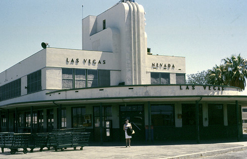
While looking for info about Dinosaur World (a place we visited sometime around 1970, I came across The Arkansas Roadside Travelogue, a website devoted to odd and interesting things the author has found in his travels around the Land of Opportunity. For example:
- Little Rock's Ray Winder Field, for 70 years home to the Arkansas Travelers of the Texas League, (and my all-time favorite minor-league ballpark).
- Monte Ne, once a resort southeast of Rogers founded by radical Progressive William "Coin" Harvey. In its heyday, Venetian gondolas ferried guests across a lagoon from the train station to the lodge.
- Possible explanations for the name Toad Suck Ferry.
- A place near Lepanto in northeastern Arkansas where two rivers cross.
- What really happened when Keith Richards was pulled over in Fordyce, Arkansas.
It's a fun site to explore, in the same vein (although not as thorough or focused) as Kevin Walsh's Forgotten NY.
American Restaurant: Mr. Swiss,
originally uploaded by nickgraywfu.
Found this photo on Flickr next to one of a beef on weck sandwich. We used to have Mr. Swiss here in Tulsa -- there's a former Mr. Swiss building on the south side of 31st Street just west of Mingo. (I think it's a used car dealership now.) Click on the picture to see a bigger version.
If you have trouble finding your way around the tidy Cartesian grid that defines Tulsa's street network, imagine learning your way around an ancient, complex, and chaotic street network, and keeping that map entirely in your head.
From the Transport for London website:
All licensed taxi drivers in the Capital must have an in depth knowledge of the road network and places of interest in London - the 'Knowledge'. For would be All London drivers, this means that they need to have a detailed knowledge of London within a six mile radius of Charing Cross. Suburban drivers need to have a similarly detailed knowledge of their chosen sector.
From a PDF document about the Knowledge of London examination system:
In order to complete the Knowledge you will need to know any place where a taxi passenger might ask to be taken and how to get there. To do this you will need to know all the streets, roads, squares etc. as well as specific places, such as parks and open spaces, housing estates, government offices and departments, financial and commercial centres, diplomatic premises, town halls, registry offices, hospitals, places of worship, sports stadiums and leisure centres, stations, hotels, clubs, theatres, cinemas, museums, art galleries, schools, colleges and universities, societies, associations and institutions, police stations, civil, criminal and coroner’s courts, prisons, and places of interest to tourists. Such places are known as ‘points’.
How do you organize all this information in your brain? You learn 320 "runs", divided into 20 lists of 16 runs. A run connects two major points, and you learn the route from one end to the other, the reverse route (which may differ because of one-way streets and turn restrictions), all points of interest along the way, and all points of interest with a quarter-mile of each end point.
After an introductory talk, you have six months to learn the first 80 runs, then you go through a self-assessment, just to see if you've got the hang of it. You have another 18 months to learn the remaining 240 runs. Then there are four stages of oral examinations, each of which may involve multiple exams before advancing to the next stage. According to Transport for London:
On average it takes an All London applicant 34 months to learn the Knowledge and pass through the examination process, 26 months for a suburban applicant.
Small wonder that that London cabbie was able to keep his composure when he unexpectedly found himself being interviewed on TV about an Internet intellectual property case. (Hat tip on the cabbie story to The Dawn Patrol.)
Ron at Route 66 News has been covering the proposed rezoning and demolition of the El Vado Motel in Albuquerque, built in 1937. Albuquerque planning staff are recommending against the rezoning and demolition, which is a hopeful sign, but Route 66 aficionados are urged to send comments to Albuquerque's planning commission.
Ron also links to an Albuquerque Journal column from 2003, praising old motels, outlining the history of roadside accommodations, and spotlighting the history of three classic motels in the city.
At least in Albuquerque, it appears that city officials understand that you can't promote Route 66 unless you preserve roadside businesses. People drive old 66 for the chance to see and stop at, maybe even stay at, motels and cafes and service stations from the heyday of the highway. Tear them down in your city, and your city becomes less compelling as a place for 66 fans to spend time.
Here in Tulsa, I am hearing that most of the Vision 2025 Route 66 money may go to a new museum/roadhouse at 12th and Riverside, rather than to promote the preservation of authentic Route 66 landmarks, like the Rose Bowl, or the tourist courts way out on 11th Street, or classic neon signs. As others have already suggested (I believe Mad Okie did, for one), put the city's Route 66 museum in the Rose Bowl.
Some sound advice from Jessica, who is fed up with restaurants that are so successful they no longer care about their customers:
I urge you all to help support those accomodating restaurants that may not have the most accomodating locations. Step outside of the neighborhoods you generally frequent. There are some gems out there that need the financial support way more than these other places. Do your research on Chowhound, like I do on a daily basis. You will be rewarded with a great meal, and probably at a lower cost. Plus, you can be a tourist in your own town.
A lot of Tulsa diners are stuck in the 71st Street rut, but there are plenty of great locally-owned places that can give you a great meal and great service for a reasonable price. Many of them are off the beaten path because they're new and the owners were looking for the least expensive storefront they could find as a place to get started. Keep an eye peeled for them, and givem them a try.
More about our Florida vacation:
After snorkeling in Key Largo, we spent the night in Florida City, at the southern end of Florida's Turnpike. We got around in time to go on a nature walk around the Anhinga Trail in Everglades National Park. The ranger who normally gives the tour couldn't make it, but his substitute did a competent job. We spotted a couple of small gators and saw a gator's nest. Joe tried his uncanny baby gator call, but it didn't bring Mama Gator running. We spent some time at the main visitor's center, then on our way back to Florida City we stopped at the famous Robert Is Here fruit stand, which sells exotic fruits both fresh and preserved in every way imaginable (chutney, jam, jelly, preserves, relish, butter, curd, marmalade, salsa). Signs tell you the name of the exotic fruit and try to describe the flavor in terms of more common fruits. (You'll find two of the fruits we saw, sugar apples and dragonfruit, on this WFMU blog entry about tropical fruit.) We bought some fresh pineapple and had them cut it up, then sat down at a picnic table to share it, along with a guanabana milk shake and a key lime tart. We bought a bunch of apple bananas, too, but we were told they weren't quite ripe. (When they were they were wonderfully sweet.)
Fresh pineapple brought back memories of my summer in Manila. One of the things I most looked forward to after the smog and swelter of the city was enjoying a wedge of pineapple that had been chilling in the refrigerator all afternoon.
After grabbing a quick lunch, we spent the rest of the afternoon indulging my curiosity about urban redevelopment in Miami, before heading north to the Orlando area. More about that in another entry.
Via The Basement comes a link to a kind of McDonald's fan blog called McChronicles. The writer obviously loves Mickey D's and expresses disappointment when he sees one of their stores fail to be all it can be. His first entry, from January:
I LOVE McDonald's ... and I HATE McDonald's. This blog will chronicle this love:hate relationship. It will include thoughts, experiences, and information regarding how McDonald's created an awesome brand - and how they seem to be systematically destroying it "Billions and Billions" at a time. It also breathes life into the notion that there is hope to resurrect the once-great image of McDonald's.
I too have a love-hate relationship with McD's, tending more toward love these days.
The summer of '84 I worked at the Catoosa McDonald's when it first opened. I remember coming home every day in my crimson polyester uniform, which was impregnated with the odor of grease and onions. Sometimes I worked the cash register, but most of the time I was on the quarter pounder grill. I learned two things that summer: (1) Eat the fries first. They put them in the bag last because they cool off the quickest. (2) A Quarter Pounder is a better value than a Big Mac. A Big Mac has two 1/10th pound patties -- same patties used in regular hamburgers and cheeseburgers -- and a half-inch of lettuce. Besides the meat advantage, the Quarter Pounder's two slices of cheese help glue the thing together, making it less likely to fall apart if you're eating it while driving. (Not that I would recommend such a practice, of course!)
We ate at McDonald's quite a bit during the driving parts of our recent Florida trip. One of the advantages is that we always knew what we would order. The kids always want Happy Meals -- plain cheeseburger for one, chicken nuggets for the other -- with Apple Dippers (peeled apple slices with caramel dipping sauce) instead of fries, and chocolate milk. (The older one will take a soda if he can talk us into it. Sometimes he can.) If we're eating in, the grownups get grilled chicken salads, which are quite good. I tried to be very clear about our order, and to make sure that it was correctly repeated back to me, but every time, no matter whether we ordered at the drive-thru window or in the store, the Happy Meals came with fries, and we always had to ask again for the apples. This streak of spud luck followed us to Perkins, a sit-down family restaurant, when our four-year-old wanted broccoli with her lunch (really!), and they brought her fries instead.
I like the new look of the stores. I call it technogoogie -- a 21st century update of the coffee shop modern look (aka Googie architecture) from the '50s, but without so much orange and brown. (Or avocado or harvest gold!) Most of the remodeled stores have wide screen TVs, usually playing Fox News or CNN, and most of them also have Wayport Wi-Fi. (SBC Yahoo DSL subscribers can access McDonald's Wi-Fi through the FreedomLink service for an extra $2 a month.)
During our trip to Little Rock, while my wife and mother-in-law were at a luncheon at the Governor's Mansion, I kept the kids busy while I worked at a McDonald's on Markham in west Little Rock. I positioned myself outside the door to the play area, where I could see them, but didn't have to listen to the racket. They kept amused with the climbing equipment, the video games (free!), and the air hockey table. Everyone was happy.
I never would have guessed, back in 1984, that I'd ever be able to say this, but McDonald's is my kind of place.
One of the delightful surprises of our recent vacation was the unexpected upgrade of our rental vehicle. We'd booked a minivan, but Dollar was out of them when we arrived at FLL past midnight, so they issued us a blue Dodge Durango SUV. (Yeah, it's got a hemi.)
In exploring the controls, I noticed the magical alphanumeric sequence "MP3" on the CD player. I just happened to have, in the case with CD-Rs of data for work, a couple of CD-Rs with a compilation of '60s music, including the entirety of King Of The Surf Guitar: The Best Of Dick Dale & His Del-Tones, plus several subtropical songs by Santo and Johnny (including a nice cover of "Harbor Lights" and a long version of "Sleepwalk"), and a few Jan and Dean tunes. The kids loved the Dick Dale album, and the four-year-old asked to hear "the surfing music" again and again. She also objected loudly when the Dick Dale music gave way to the opening bars of Gene Pitney's "Town without Pity" -- the next folder in sequence on the CD. (I know, I know. The self-pitying lyrics are ludicrous, and what self-respecting girl could love someone singing such whiny lyrics with such a whiny intonation, but you have to love the saxophone solo, and the song is sufficiently over the top to have some camp value. Plus I can't hear the song without thinking of John Belushi singing it in an SNL sketch about Indira Gandhi losing an election to an Untouchable -- who turned out to be Dan Aykroyd playing Robert Stack playing Eliot Ness. But I digress.)
So the rapid-fire picking of Dick Dale and the sultry slide of Johnny Farina's steel guitar formed most of the soundtrack of our tour of the land of swaying palm trees and crashing waves.
Most of the soundtrack, but not all, as the vehicle had another nice surprise -- Sirius satellite radio, which has an excellent "standards" channel playing music from the Great American Songbook.
(While waiting in line for the Enchanted Tiki Room show at Disney World, listening to what sounded like Martin Denny's "Quiet Village" on the PA system, I realized that we should have had some '60s exotica to fill out our Florida playlist -- that, and some Jackie Gleason Orchestra.)
When we picked up the car, I assured my wife that if we'd rather have the minivan, Dollar would exchange it when one was available. After I discovered the MP3 player and the satellite radio, I told her there was no way we were turning the Durango in, 18 MPG and $2.50 gas notwithstanding.
For the record, the soundtrack for last year's family vacation through Texas was "No!" by They Might Be Giants.
Why is it that, when Dawn Summers writes about traveling somewhere, whether to LA or New Jersey, it reads like one of the lost books of Homer's Odyssey? (Or would, if the Odyssey were laugh-out-loud funny?)
I don't get this.
The Whirled reported today that Sen. Jim Inhofe has introduced a bill that would force Southwest Airlines to move from Love Field in Dallas to DFW Airport.
Knowing how much the Whirled hates Sen. Inhofe, I'm sure this must be some kind of smear. I am sure that Sen. Inhofe is fully supportive of Nevada Sen. John Ensign's efforts to eliminate the anti-competitive Wright Amendment, which sacrificed the interests of the traveling public for the sake of one favored airline and one favored airport. The Wright Amendment, as originally passed by Congress in 1979, singled out Love Field and prohibited direct flights between that airport and airports in states not contiguous with Texas.
Ensign and other sponsors of the American Freedom to Fly Act want to completely repeal the Wright Amendment and allow Love Field to operate like any other airport in the country. Here are some of the idiotic restrictions that the Wright Amendment imposes:
- Restricts flights from Love Field to Texas, Oklahoma, Louisiana, Arkansas, New Mexico, Alabama, Mississippi, and Kansas.
- Flights from Love to Alabama, Mississippi, and Kansas cannot fly on to other states, but must return to Love before flying elsewhere.
- You can't buy a through ticket from Love via another city within the Wright Amendment zone to a city beyond the zone -- e.g. Love to Tulsa to Chicago. The airline can't even tell you that such a combination is possible. You have to figure it out and buy the two tickets separately. (I don't know this, but I'll bet the airline isn't even allowed to transfer your bags to an onward flight in this situation.)
The Wright Amendment is a fitting legacy for former House Speaker Jim Wright, famous for being forced from office for ethics violations. (Remember his vanity-press book, Reflections of a Public Man, which was purchased in mass quantities by lobbyists who wanted to help him skirt outside income restrictions?) Republicans swept away much of his dubious legacy when they gained control of the House in 1995, but this is one last bit that deserves to be trashed. I'm hopeful that Oklahoma's pro-freedom, pro-competition congressional delegation will lead the way in eliminating this provision that stinks of favoritism and crony capitalism.
Postcard found in a Nebraska truck stop -- a beige relief map of Nebraska with the caption, "NEBRASKA: No Relief." On the back of the card: "There's a reason it's called a plain state. Road-weary pioneers just gave up and stayed. Their descendants are the counter clerks who sell these cards."
(The card is published by Ersatz Nebraska, 800-300-1050 x04.)
It really does go faster if you load the plane from the back forward.
What Einstein came up with the idea of loading front to back?
Personally, I look forward to the day that they line us up in the terminal on a seat map stenciled on the floor, then march us on in exact order.
NOTE: Entry started on May 16, 2005, extended and published on December 1, 2015. I may add to this.
Back in late May and early June 1994, my wife and I spent one week each in Scotland and Ulster. I wrote about our favorite places and where we stayed and posted it on Usenet. Nothing ever completely disappears from the Internet -- those articles can still be found at travel-library.com:
Scotland: highlights of a recent visit
There was barely a World Wide Web when we took that trip, but now many of the accommodations and attractions are online. For example:
Leault Farm sheepdog demonstrations near Kingussie, Inverness-shire, Scotland.
Mr & Mrs McPherson B&B, Inveraray, Argyll.
Brownlees Guest House, St Andrews, Fife.
Ashdene House, B&B in Edinburgh.
The Hall Greene farmhouse accommodation near Lifford, Co. Donegal.
The Hall Greene was our favorite place to stay. Mervyn and Jean McKean are wonderful hosts. Active in the Ballylennon Presbyterian Church, they shared our interest in the history of Presbyterianism in Ulster, particularly the region in eastern Donegal called the Laggan, which had been home to my ancestors in the early 18th century. Jean is also a wonderful chef and baker, and we enjoyed all sorts of dainty treats with tea and conversation in the parlor.
We enjoyed our visit to Ulster so much we returned in fall 1995, spending several days at the Hall Greene and several more in Ardara and Narin on the west coast of County Donegal.
We worshipped at Fahan Presbyterian Church, where my ancestor Joseph Reagh had ministered from 1742-1769, before he emigrated to America. After the service, the Lamberton family invited us to Sunday lunch, and then we had dessert (strawberry-rhubarb crumble) with Mr and Mrs Jack Lamberton -- Jack, patriarch of the family, was clerk of the church's session.
One evening, the McKeans invited us along to a time of worship and fellowship at the Presbyterian Church in St. Johnstons. It was in connection with an evangelism outreach sponsored by several area churches.
During our time in and around Ardara, we started at the Bay View Country House, which was nice, but didn't really have a view of the bay. We moved to a very nice B&B called Roan Inish (or click here for another link) in Narin, looking out over a broad sandy beach. Ardara is a center of tweed production, and I bought a beautiful jacket at a ridiculously low price, one I still wear. During our stay we had lunch at the renowned pub known as Nancy's.
Our route back to Belfast took us along the northwest coast of Donegal, with a stop in Ramelton, and the church where Francis Makemie, the father of Presbyterianism in America, was once pastor. In Derry we made a quick visit to the library in search of genealogical information. The two places we'd stayed near Belfast the previous year were unavailable, so we wound up at a B&B near the airport in Templepatrick.
In my last day or two at FlightSafety, I was going through my old engineering notebooks and remembering some of the projects I worked on. Occasionally some non-engineering thoughts were recorded on the page.
During a business trip to Montreal in the summer of 2001 I came up with an idea for a website devoted to helping business travelers find hotels with the kinds of amenities I wanted -- amenities that you couldn't usually specify when searching online for a hotel.
I was staying in the Hilton at the entrance to Dorval Airport, spending as little time in the hotel as possible. (Montreal is one of my favorite cities, but the area around the airport looks like the area around the airport anywhere else.) The Hilton is a full-service hotel, with a restaurant, a bar, meeting rooms, a concierge, a gift shop, and a pool.
Like most full-service hotels, every little thing at the Hilton was extra. Local phone calls had a surcharge. Long-distance calls had a surcharge. There were a dozen free TV channels -- and pay-per-view. And there was a refrigerator in the room, but it was a mini-bar -- stocked and checked daily, so I couldn't buy cheap sodas at the supermarket and keep them cold. The bed wasn't even that comfortable. I do not remember if there was a mint on the pillow, but I am sure I did not care. On subsequent trips, I stayed elsewhere.
Full-service hotels were apparently designed for the business traveler with an unscrutinized expense account. FlightSafety has a fixed $25 per diem for meals and incidentals in the U. S. and Canada, so I would find ways to save money, like buying sodas and snacks at a grocery store. A traveler could keep receipts for the whole trip, and get reimbursed for actuals, but it never seemed worth the bother, and I doubt they would have reimbursed me for a soda from the mini-bar.
The hotel rooms that have what I like are usually much less expensive than the full-service type, and the extras are included in the price. Here's what I look for in a hotel room, beyond the basics of comfort, cleanliness, and security:
- Full extended basic cable -- all the channels you'd get if you lived in the town, including C-SPAN. Especially C-SPAN. C-SPAN is an effective noise-blocker and sleep aid. Extra-strength C-SPAN (officially known as C-SPAN2), with the special ingredient Senitcuvraj, is even more effective, and the only side effects are disturbing dreams about Orrin Hatch.
- A free local paper. I'll read USA Today if I must, but I'd rather learn something about the city I'm visiting.
- Free high-speed Internet access in the room, preferably wired access. This is non-negotiable, especially now that I'm a big-time blogger. The most frustrating Internet / hotel experience I ever had was at the Residence Inn in midtown Savannah, Georgia. The phone system was so old, it could only manage a 28.8 kbps connection when it could manage a connection at all. Of course, the Residence Inn charged for each local phone call. To her credit, the manager refunded the fees for the failed connection attempts, but I stayed elsewhere on future visits. The second most frustrating experience was at the Comfort Suites in Wichita. They offered wireless Internet "in every room," but it was done using a single wireless hotspot in the hotel's atrium. When I complained about the flakiness of the connection in my room, I was told that I should have requested a non-corner room if I wanted to use the Internet.
- A fridge and a microwave, so I can have cold sodas handy, keep and reheat leftovers from enormous restaurant meals, and have something that isn't entirely starch and sugar for breakfast. The Hampton Inn in East Aurora, New York, offered a free breakfast each morning, but it was 100% carbs, so I'd eat in my room. I'd slap a pre-cooked ham steak and a slice of swiss cheese on a piece of bread, heat it in the microwave long enough to melt the cheese, then top it with good ol' Buffalo-style horseradish (and plenty of it) and another piece of bread.
- An iron and ironing board. I never use one at home, but at home I can fluff a wrinkled shirt in the dryer.
- Plenty of accessible outlets -- one for the laptop, one for the cellphone recharger. Don't make me move the bed out from the wall to plug something in.
- A clock radio that can actually pick up the local news-talk station inside the hotel. Bonus points if I can move the alarm time forward and backward. Extra bonus points if the radio isn't reset to the chambermaid's favorite station every day.
- A decent place to work -- a desk at the right height, a comfortable chair, a phone nearby, plenty of outlets and an Internet hookup, with a view of the TV.
- Good pillows and plenty of them.
If the hotel is in an interesting, walkable area -- like Savannah's Historic District -- I can do without the TV. In a place like Altus, Oklahoma, it's an absolute necessity.
That really isn't too much to ask, is it? More and more mid-range hotel chains seem to be offering those sorts of amenities as standard features, which means my website idea isn't really needed now. Wingate Inns started offering free high-speed Internet in every room in 1999, along with a fridge, microwave, a cordless phone, ironing board, and full basic cable. Other chains have been slowly catching up. I've noticed that Hampton Inns appear to have standardized over the last year with free high-speed Internet in the rooms, WiFi in the lobby, hot breakfast with scrambled eggs and sausage, and free local calls.
So what are your business travel hotel must-haves and pet peeves? Leave a comment.
I enjoy traveling and seeing new places, but my current trip has been spent mainly in a computer room or in my hotel room, or traveling through the dreary industrial wasteland between the two. As I mentioned, this has been a particularly solitary trip, and dining alone, often a welcome break from constant interaction with others, has been a real drag. "Table for one" gets pretty depressing after a while.
So I want to send special thanks to some people who have been kind enough to invite me out for a meal and some good Christian fellowship.
Sunday morning, after a wonderful time of worship and teaching -- not the kind of traditional service I normally prefer, but nevertheless one that really spoke to my needs -- I caught up with WMCA talk show host and blogger Kevin McCullough and his lovely wife, and they treated me to a delicious Italian brunch and some great conversation (also about faith, family, and politics, as well as radio). I met Kevin during the Republican National Convention, and he has been a great friend to BatesLine, giving this site an honored spot on his list of premium blogs and also advertising here.
Many thanks to the McCulloughs for their friendship.
Found on the table, in a plastic sheet protector:
WELCOME In ancient times, there was a prayer for the "Stranger within our gates."
Because this Inn is a human institution to serve people, and not solely a money-making organization, we hope God will grant you peace and rest while you are under our roof.May this room, and Inn be your "second" home.
May those you love be near you in thoughts and dreams.
Even though we may not get to know you, we hope that you will be as comfortable and happy as if you were in your own home.May the business that brought you our way prosper.
May every call you make and every message you receive add to your joy. When you leave, may your journey be safe.We are all travelers. From "birth til death" We travel between eternities. May these days be pleasant for you, profitable for society, helpful for those you meet, and a joy to those who know and love you best.
If things go wrong, we want to know. If things go right, we want to know. We are here to show you what Maryland hospitality is all about. Sit back, relax, let your hair down and enjoy.
We hope you stay with us is a pleasant one and that we will be able to serve you again in the future.
The Staff and Management.
Charles of Dustbury lists some of his life's ambitions (them that are printable, or nearly so). One of them is to drive a couple of the diagonal U.S. highways that are still official: US 62 from El Paso, Texas, to Niagara Falls, New York, and US 52 from the Canadian border in North Dakota to Charleston, South Carolina.
Never thought about 52, but US 62 has fascinated me for a long time. It is the only even-numbered U.S highway that stretches from border to border. It isn't coast to coast, but it does begin and end at a water boundary -- the Rio Grande and the Niagara River.
It passes Carlsbad Caverns and near Mammoth Cave. It covers the flat arid lands of the Texas panhandle, the Ozark mountains, and the hills of Ohio. It passes through ten states -- the shortest segment is in Illinois, through the town of Cairo, at the confluence of the Mississippi and Ohio Rivers.
In Oklahoma alone, it passes through diverse terrain -- cotton fields and the Quartz and Wichita Mountains in western Oklahoma, Green Country and the Cookson Hills in eastern Oklahoma. Two state capitals are on 62 -- Oklahoma City and Columbus, Ohio, as are at least two tribal capitals (Tahlequah and Okmulgee). (Anadarko is home to Indian City USA, but is it a tribal capital?)
During my week-and-a-half trip to western New York, I had last Sunday afternoon off to roam a bit. I spotted a marked scenic route on the AAA map about an hour east of Buffalo -- Letchworth State Park, near Perry, New York. After a morning storm, the day was perfect. I headed east on US 20A, past countless dairy farms, over hills and through deep valleys. The terrain reminded me of the Ozarks. The approach into the town of Warsaw is so steep that heavy vehicles are required to exit the main road into an area that looks like a weigh station, but the only thing there is a large sign mapping the road ahead, showing where the steep grades and curves are, and reminding truckers to use low gear and conserve braking capacity.
Warsaw, the seat of Wyoming County, is a pretty little town. I spent some time walking around and admiring the neatly kept craftsman-style and late Victorian homes before grabbing a late lunch at the local Chinese buffet.
If I had known how amazing Letchworth State Park would be I would have headed straight there. The name doesn't do it justice. It really ought to be called "Amazingly Beautiful Gorges and Waterfalls State Park". But the name is a fitting tribute to the man who bought the land about 130 years ago, worked to restore it to native condition, then donated it to the state of New York in the early 20th century.
The park encompasses the gorge of the Genesee River. At places the walls are 500 feet high. The river goes down three waterfalls -- the Middle Falls has a 100 foot drop. Further down river, Wolf Creek drops from the western rim of the gorge through a narrow, twisting gorge of its own, down several stages of waterfalls to the river 200 feet below. Nearby viewing areas give you tantalizing glimpses of part of the Wolf Creek falls, but there is no place to stand to see all of it at once. Down below on the river I noticed some kayakers and rafters who had stopped for a few minutes to rest and look.
At the lower falls, you can take steps down to a viewing area only about 20 feet about the river. There's a footbridge to a walkway on the east bank of the river. The east bank path was treacherous. I had to walk around a three-foot high chunk of ice and snow -- protected from the sun -- and in the process slipped and fell. I thought I was walking on mud, but it was mud and slippery chips of shale on top of a nine-inch thick pad of ice which covered the entire walkway. I recovered and made it safely back to the car, thence to Inspiration Point and views of the middle and upper falls.
As I looked at the upper falls, I started thinking about the gospel chorus based on Revelation 4:11 -- "for thou hast created all things, and for thy pleasure they are and were created." What an amazing thing that God, who lacks nothing, nevertheless takes great enjoyment in creating and looking upon such beauty.
I drove off into the setting sun, listening and singing along with "Best Loved Hymns", an album by the Choir of King's College, Cambridge, with beautiful arrangements that go from quiet a cappella to triumphant brass. A lovely Sabbath break from the grind.
National Review's The Corner linked to the website of an idiosyncratic magazine called "The Believer". Not a religious website, I'm not sure how to characterize it. They have regular features on power tools, motels, and mammals.
The motel section included an article on the Snow Flake Motel in St. Joseph, Michigan, which was designed in the style of Frank Lloyd Wright by William Wesley Peters, Wright's son-in-law, and built in 1962. The motel is built in the shape of a snow flake and looks like no other motel you've ever seen, inside and out.
My friend Rick Koontz and I ended up spending the night there in the middle of our 1988 "Rust Belt" tour, a week-long swing through the Great Lakes states, taking in five major league baseball games in six days. (One of the motivations was to visit the old ballparks before they were gone forever. Funny to think that the newest one we visited -- Riverfront Stadium in Cincinnati -- is gone too.)
After an early departure from a Chicago White Sox game in the original Comiskey Park (we were thrown out for complaining about drunken floozies spilling beer on us), we started out for Detroit. If I recall correctly, we were ready to find a place for the night, saw the sign advertising the motel and decided to stop. It was a bit down-at-the-heels then, but it seems that matters have gotten worse, and the owner, a Mr. Patel (really), despairs of attracting the investment needed for a first-class restoration.
Jet Set Modern has some good photos. So does the website of the motel, which has an aerial photo. If you're flying into Chicago from the northeast, look out the window as you approach Lake Michigan. It's easy to spot.
Someone has graded the world's flags based on their aesthetic qualities. Here is the full alphabetical list of flags and their ratings. Flags get marked down for having the name or any other kind of writing, a map, or representational art, too many stars, "eyewatering" or nauseating color combinations, and lack of originality.
Some sample remarks:
Turkmenistan: Flag actually includes a Persian (sorry, Turkmen) carpet. Only flag to both make eyes water and induce vomiting.Mozambique: Automatic weapons on a flag are especially bad. Appears to have been designed by a committee all of whom had stupid ideas for pictures of extra things to put on the flag.
(Hat tip to The Corner.)
What do I have against the northwest quadrant of the US?
create your own personalized map of the USA
or write about it on the open travel guide
I really hate the drive to Wichita. It is desolate. The Cimarron Turnpike is so seldom traveled that no one has figured out a way to make money by building a gas station or restaurant at the exits. And once you're done with the Cimarron, it's another 20 miles north on I-35 before you get to a place where you can buy a Coke and use the potty. The road gets monotonous. Every road can be monotonous at night, but this road is even boring by day. Once you leave Sand Springs behind, the next settled area visible from the highway is Wichita.
So on the trip up, I took an extra 40 minutes or so to go by way of Ponca City, Newkirk, Arkansas City, and Winfield, up US 77 and Kansas 15. It was worth it. Although I didn't take my usual detour down Grand Boulevard in Ponca City, and I missed getting to Head Country BBQ before it closed, I did enjoy seeing the restored and interesting downtowns of the other three cities.
On the way home, I took a less extensive detour through Tonkawa, stopping at the local convenience store and hangout for a Coke, then joining the Cimarron south of town. I don't think I'd ever been through Tonkawa before. That stretch US 77 is only a couple of miles east of I-35, so it didn't cost me much time, although it nearly cost a raccoon family its life -- they weren't accustomed to seeing traffic.
I'm on my way home from three days in the vicinity of Buffalo, New York. This is my third trip there in as many months.
When I travel, I make a point to learn about local favorites. I could easily eat all my meals at national chains, but I don't make interesting discoveries that way. On my first trip to Savannah, back in 1997, I was looking for a place to eat Sunday lunch. The legendary Mrs. Wilkes' Boarding House doesn't serve on Sundays, but there was an ad in the local weekly for a new little place called The Lady and Sons, advertising a Southern buffet. I went, had a wonderful meal, and bought my wife a copy of the restaurant's self-published, spiral-bound cookbook. I met the owner, Paula Deen, who autographed the cookbook for my wife: "Shake those pots and pans!" Today, Paula Deen has her own weekly show on the Food Network and the restaurant has moved to a new location four times the size of the old one. And I got to eat there before it became famous.
On my first trip to the Buffalo area, we had lunch brought in. Hot, thin-sliced, roast beef au jus; big rolls, sort of like kaiser rolls, but with caraway seeds and coarse salt baked into the top; and as a condiment, a dish of horseradish. Not "horsey sauce", but the real deal. As world-famous as Buffalo wings are, I am told that beef on weck is the unofficial sandwich of western New York. (Weck is short for kimmelweck or kummelweck roll.) Every tavern serves it -- I had a particularly good one at the Bar Bill Tavern in East Aurora -- and most local restaurants too.
There's something about the combination of the caraway seeds, salt, and horseradish. And there's nothing like a big bite of horseradish to clear the sinuses. I have to admit that part of the appeal of the sandwich in cold and flu season is its medicinal qualities.
This afternoon I had a late lunch at Danny's Buffalo Cuisine near the airport and ordered a beef on 'weck. I got way too much horseradish in the first bite. I felt the heat spread through my sinuses. My eyes began to water, my ears began to burn, my face flushed, and my nose started to run. The waitress was over in an instant to ask, "Is everything OK?" I thought I detected in her voice a note of genuine concern for my well-being. You could easily mistake my symptoms for the signs of an imminent emotional collapse. I choked out the words, "Everything's fine, thanks." And it was.
I had a free day yesterday and decided to go cross-country skiing. I had enjoyed the sport a couple of times in college, but had never had the opportunity since. Western New York has several ski resorts that take advantage of the hilly terrain and lake-effect snows. I headed to the Holiday Valley resort near Ellicottsville, New York, about an hour and a half south of Buffalo. The drive took me through beautiful country and pretty villages -- places built when people took pride in what they built, places preserved by their successors who could appreciate the value of what they inherited.
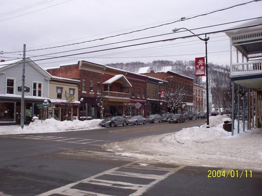
The resort's parking lot was packed. It was evident that the resort, probably the largest in the area, was geared for downhill skiing and snowboarding, with cross-country accommodated but not emphasized. When I asked a staffer where I could ski, the staffer had to find someone else to answer the question. I could take a lift to the top of the mountain and ski along the ridge trail, then take a lift back down, or I could go down to the golf course, which serves as a cross-country course during the winter.
I opted to avoid the crowds waiting for the lift and headed to the golf course. I had the place to myself. It was wonderfully quiet, with a light snow falling. I spent about an hour and a half, a good workout, but not so much that I'd be racked with pain the next day.
Why not downhill? I tried it once, at Keystone, about 10 years ago. It took three days to get boots that didn't kill my feet. (I have a high tolerance for pain, so that's saying a lot). It was only on the third day that I finally got all the way through a lesson, and I decided to go ahead and go with my wife up the lift and down an easy slope. I still didn't have the hang of controlling my speed, got moving too fast, so I sat down. One ski didn't pop off and I wound up with a sprained MCL. It might have been better this time, but with only part of a day to spend, I thought I'd better do something with less of a learning curve and lower odds of injury.
I observed today's centenary of controlled, powered, heavier-than-air flight by flying, and passing through the world's busiest (and nicest) airport. In an era when air travel is in decline -- ever more inconvenient and uncomfortable -- it was nice that my centennial flights were relatively comfortable and trouble-free. No one in the next seat on both flights, and lots of leg room on the A319. There were the usual annoyances with flying a segment on a commuter airline -- gate-checking the rollaboard, then waiting in the cold for it to be returned, walking 100 yards in the cold from the plane to the gate. I find I have to reorganize my carry-on bags three times -- once to smooth passage through security (laptop out and ready to inspect), once for the commuter jet flight (no valuables or fragile items -- the laptop specifically -- in the gate-checked bag), and once for the big jet flight (stuff I wanted handy under the seat, the rest in the overhead bin).
I flew United for the first time in ages. Service was great. The ticket agent saw that the delay of the first leg of the flight might prevent me making the connection, so he reserved a spot for me on a later backup flight. Boarding was smooth. The A319 had good music on the headsets, or I could watch a Frasier episode. The seats have adjustable headrests.
Funny that both my flights on this centennial day were on foreign-built aircraft -- a Canadair Regional Jet and an Airbus A319, made in French-speaking Canada and in France, respectively.
I refer to O'Hare as the world's best airport. When my wife worked for Sabre, then part of American Airlines, we did a lot of standby travel and spent a lot of time waiting for flights in airports all over the country. O'Hare's tree layout makes it quicker to go from one gate to another. The semi-circular layout used at DFW guarantees a long walk for most passengers. In algorithmic terms, the time to go between any two gates at ORD is O(log n), at DFW it's O(n).
If I had to pick a place to get stuck, I'd pick O'Hare any time. It seems more spacious, less crowded, even when it's busy. Atlanta is crazy, especially near the nodes where the terminals connect with the interterminal train. Getting around DFW is all about dodging the carts, which have to be made available because it is so far between gates. DFW always seems to have spillover into the main corridor -- seldom see that at ORD.
ORD has more amusements. The Chicago Children's Museum has an exhibit and play area in Terminal 2 that is a great place to take the kids to while away hours and burn energy between missed standby flights -- lots of steps to climb, slides to slide on, big vinyl-covered foam blocks to stack (pretend cargo), knobs to turn, and buttons to push. (But they seem to have gotten rid of the cool Sears Tower made of Legos.) In the United terminal (Terminal 1), there is a replica life-size brachiosaurus skeleton.
ORD has made their restrooms the envy of the airport industry. I remember during my student days, flying through ORD, that the restrooms were tiny, crowded, and smelly. Over time they've opened things up, gotten rid of the entrance doors, to make it easier to navigate with luggage, and installed all manner of automatic conveniences. With the exception of shutting the stall door, you could get through a visit to the restroom without touching anything other than your own person, which is a good thing with all the wild viruses that must pass through O'Hare from all corners of the globe. What genius came up with automatic toilet seat covers?
Of course, airport comforts don't have much to do with aviation per se, but isn't it amazing that flying is so reliable and so routine that we can afford to be more worried about whether the seatback fully reclines than whether a part will fall off the plane.
We descended from bright sunshine through a thick layer of clouds, emerging a few thousand feet above the ground as fat snowflakes blew past. In the dim late afternoon, the woods were monochromatic -- black leafless trees, adorned with white snow, not a splash of color to disturb the view. Then suddenly, there's the airport. 100 years after Kill Devil Hill, I thank God for the Wright Brothers and how their invention brought the world closer together. I also thank God for whoever invented ILS and anti-icing systems and made it possible to land a plane safely in a snow storm.
P.S. The Smithsonian, from 1914 to 1942, tried to discredit the Wright Brothers as the first flyers, in favor of the Smithsonian's own Samuel Langley. In 1914, they went so far as to reconstruct Langley's failed machine of October 1903, modify it significantly, and flew the modified aircraft, allowing the Smithsonian to make this claim:
In 1918, Zahm had Langley's Aerodrome restored to its 1903 condition and put on display in the museum with the label: "The first man-carrying aeroplane in the history of the world capable of sustained free flight. Invented, built, and tested over the Potomac River by Samuel Pierpont Langley in 1903. Successfully flown at Hammondsport, N.Y., June 2, 1914." An audacious claim, to say the least. Indeed, "it was a lie pure and simple," writes Fred Howard in "Wilbur and Orville." "But it bore the imprimatur of the venerable Smithsonian and over the years would find its way into magazines, history books, and encyclopedias, much to the annoyance of those familiar with the facts." The lie lasted 25 years. Angered at the Smithsonian's refusal to retract its statements even in the face of published articles describing Curtiss's modification of the Aerodrome, Orville Wright sent the 1903 Flyer to the Science Museum in London in 1928. In 1942, a new Smithsonian regime finally retracted its Aerodrome claims and privately acknowledged wronging the Wrights.
It's a fascinating story.
UPDATE: In honor of the day, here is the FAA-annotated version of "High Flight".