Main

Tulsa::History Archives

June 18, 2007

The rise and fall of Greenwood

I've been so busy creating content for this coming week's Urban Tulsa Weekly that I haven't had time to link the current issue's column. It's about what I call the Greenwood Gap Theory, the widely-held notion that nothing happened in Tulsa's one-time African-American commercial district between the 1921 Race Riot and the late '80s construction of the OSU-Tulsa campus.


greenwoodpolksample.JPG
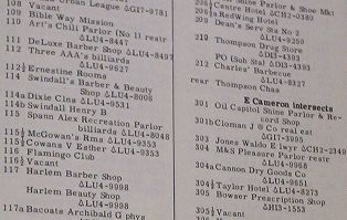
To fill the gap, I look at the historical record provided by aerial photos, street directories, and oral histories, all of which reveal that Greenwood was rebuilt after the riot, better than before in the view of many, but it was government action -- in the form of urban renewal and freeway construction -- that produced the empty lots in the '70s which OSU-Tulsa replaced.

An annotated aerial view of Deep Greenwood (the part of the district extending a few blocks north of Greenwood and Archer) from 1951 accompanies the story. Here's a larger version of the graphic for your perusal (1 MB PDF). (The scan of the aerial photo was done by INCOG at a cost of $35. INCOG has aerial photos of the entire county taken at roughly 10 year intervals.) And this photoset contains the pages from the 1957 Polk City Directory for N. Greenwood Avenue, showing the businesses, churches, and residences in house number order. Specifically they are pages 357 through 360.

March 30, 2007

Remembering east Tulsa in the '60s and '70s; Tulsa street names

Over on the TulsaNow forum, Steve, who has collected some very interesting material on the history of his current neighborhood, Lortondale, has written some of his memories of growing up in Tulsa in the '60s and '70s and is inviting others to do the same. He grew up in Moeller Heights and attended the very modern St. Pius X Catholic school and parish in that neighborhood. (The neighborhood appears to be named after the owner of the farm on which the neighborhood was built; the parish met in the barn before the building was completed.)

Also, there's a discussion about the origin of Tulsa's street and avenue names. If you're curious to know who named the streets and why the names were chosen, or if you have some knowledge to share on the topic, click on through.

March 15, 2007

You mean it wasn't named to honor Lewis Meyer?

From the March 11, 1957, Tulsa Tribune we learn which Lewis gave his name to Tulsa's Lewis Avenue:

Services for Mrs. Elizabeth Bell Lewis, widow of S. R. (Buck) Lewis, pioneer Tulsa attorney and real estate developer for whom Lewis Avenue was named, will be at 3 p.m. Tuesday in the Musgrove Funeral Home at Claremore.

Burial will be in Woodlawn Cemetery there.

Mrs. Lewis, 84, died in a Claremore convalescent home Saturday after an illness of six months. She lived in Tulsa for many years before returning to her native Claremore last fall.

Her husband died in February, 1950. He had lived in Tulsa since 1887 and was a Democratic Party leader for many years.

He organized the Cherokee Land Co., a real estate firm which developed the Cherokee Heights Addition north of Archer Street and west of Lewis Ave. He also helped write a three-volume "History of Tulsa" and wrote "History of the Cherokees."

Mrs. Lewis was a first cousin of the late Will Rogers, former state Sen. Clu Gulager of Muskogee and the late John Gulager, Muskogee County judge, and a second cousin of former state Sen. Dennis Bushyhead of Claremore.

She was a sister of Mrs. A. V. Robinson of Claremore.

March 14, 2007

A farewell to Phantasmagoria

Blogger Kirk Demarais of Secret Fun Spot has long been fascinated by Phantasmagoria, the dark ride at swiftly vanishing Bell's Amusement Park. He detailed his history with the ride, along with photos and sketches, in this entry from February 8.

As sometimes happens when you post something on a blog, he got a reply from someone else with an interest in the topic -- long-time Bell's electrician Buddy Stefanoff, who offered Kirk the chance to come look around inside the ride as it was being dismantled and packed to move. In the process, Kirk learned more of the history of Phantasmagoria and some of its intriguing secrets.

"Farewell" may not be the right word, actually. Toward the end of that second entry you'll find a sneak preview of a concept for a new dark ride at Bell's new location, wherever that may be.

On a related note, a couple of days ago my wife and six-year-old daughter were driving past Expo Square on 21st Street, and as they went past Zingo, my little girl -- and she's small for her age -- started talking excitedly about all the rides she could ride this year that she was too short for last season. That's when my wife had to break the news -- Bell's was going away. She sobbed the rest of the way home.

From my years of involvement with the Midtown Coalition of Neighborhood Associations, I know how relieved the immediate neighbors are that Bell's is going away. Personally I never wanted to see it leave entirely; I liked one Sunrise Terrace homeowner's proposal to have Tulsa County accommodate Bell's expansion toward the interior of Expo Square, along the State Fair Midway and away from the neighborhoods. Neighboring homeowners very reasonably wanted to prevent any encroachment into the open space buffer along the west side of the Fairgrounds.

There was a long legal fight to revoke the county's permission for Bell's to construct a new coaster closer to the neighborhood, and it was finally resolved this last year with a compromise. With Bell's gone, the neighbors won't have to worry about Bell's expansion plans anymore.

They will have to worry about whatever County Commissioner Randi Miller plans to put in its place. Oh, she says they don't know what's going to be done with the land, but you don't throw away a revenue source without something in mind to replace it. My intuition is that Miller has known what will be going in there since long before she announced that Bell's was being evicted, but she isn't yet willing to take the political flak for the decision.

(The neighbors will have more say over what will replace Bell's if the City of Tulsa annexes the Fairgrounds. Without annexation, only the County Commissioners and officials directly appointed by them will have a role in choosing the new use. With annexation, any change in zoning, any special exception, or variance would have to come through the City of Tulsa's zoning process, and would be more likely to be compatible with the surrounding neighborhoods.)

Would it have killed Miller and the Fair Board to give us just one more summer to say goodbye to the park as it has been for decades?

MORE: Kirk has a new post up about the White Lightnin' log flume ride.

February 22, 2007

Lortondale history

There's an interesting thread over at the TulsaNow Forum about the history Lortondale neighborhood, on the east side of Yale Avenue at 26th Street. The subdivision of homes with low pitched roofs and glass walls was built in 1954 on what had been a farm belonging to the publisher of the Tulsa Whirled (thus the name) and later the original site of Meadowbrook Country Club (now on 81st Street between Memorial and Mingo).

One of the fascinating facts supplied by Steve, a 20-year resident of the subdivision:

Lortondale was the very first merchant builder (speculative) housing development in the United States where all homes were built with central air conditioning as a standard feature, built on slab foundations with in-slab forced air HVAC ducts. Builder Howard Grubb and the Chrysler Air-Temp Corporation featured Lortondale homes in their national magazine ads at the time, and Lortondale made national homebuilding news for this "luxury" feature. An historic homebuilding fact, right here in Tulsa.

He also mentions that Grubb built two model homes in Mayo Meadow neighborhood, just east of Pittsburg on 21st Place.

Lortondale's MySpace page has a scan of the original owner's manual for the homes, plus many contemporary photos and magazine articles about the development's modern features. The neighborhood also has a very well-designed website (although it doesn't seem to be working at the moment).

I'm pretty sure The Incredibles live in Lortondale, or someplace very much like it. Here's a 1956 view of a Lortondale home. (Flickr photo uploaded by Hoodlam.)

And here's a still from The Incredibles (image found here):

incredibles_house_.jpg

February 2, 2007

Forgotten Tulsa: Locust Grove Park

I found a very heartwarming thread over on TulsaNow's public forum. Someone calling himself "Hometown" has posted memories and photos from the neighborhood southeast of downtown which was displaced by the construction of the southeastern interchange of the Inner Dispersal Loop. The neighborhood linked together the south edge of downtown -- home to car dealerships and churches -- with the 15th Street (Cherry Street) commercial district, the Tracy Park, Gunboat Park, Maple Ridge North, and South Boston neighborhoods. And the heart of the neighborhood was a grove of locust trees that became a city park, Locust Grove Park.

Hometown's description includes details of the park that he gathered from old maps and newspaper stories and his own memories of living nearby.

Some of my very first memories are of Locust Grove Park. In 1959 we lived on 14th between Cincinnati and Detroit. I was six years old. I can remember sitting in our small front yard at dusk and watching a group of square dancers under the lights of the basketball court. The women wore layers of petticoats causing their colorful skirts to puff out and swirl around. A man with a fiddle called out the dance moves.

It’s hard now to imagine that children played in the park and around the neighborhood with little or no supervision. We would take off and walk blocks into downtown or over to the Gunboat neighborhood or further to Tracy Park. But we spent most of our time in Locust Grove Park.

He has a picture of himself in front of the park's recreation center in 1959, in front of his house on 14th Street between Cincinnati and Detroit in 1960, and the next house he lived in, on Norfolk Ave. in Tracy Park, in 1960 -- the houses in the background of the photo were demolished for the construction of the east leg of the IDL (I-444 / US 75).

Other people who remember that place and time are chiming in with memories of their own. Hometown promises more photos and more memories in the future.

This is exactly the sort of recording and sharing of memories that I had hoped would emerge in this centennial year. (It was the topic of my column in this week's UTW.)

Hometown's tagline on the TulsaNow forum is "Tulsa's best days are ahead of us." If that's to be true, we need to remember the good days that once were. We need to remember what Tulsa was like before our leaders began to shred it to pieces, so that we can, to whatever extent possible, repair the damage that was done.

January 31, 2007

River revue

The big story I've been working on is finally in print. This week's Urban Tulsa Weekly cover story is the epic tale of a century -- yes, a century -- of Tulsa's plans to do something interesting with the Arkansas River.

This story was a blast to research. UTW's Holly Wall and Siara Jacobs rounded up copies of articles and documents from the 1968 and 1976 plans from the very helpful folks at the River Parks Authority. I spent hours paging through Central Library's "vertical files" and repository of old planning documents. I had far more material than I could use. I was helped immensely by a conversation with architect Rex Ball, whose firm developed the 1968 River Lakes Park plan, and by my long acquaintance with Jim Hewgley III, who was Streets Commissioner when the Zink Lake low-water dam was built by Mayor Jim Inhofe.

It's my intention to scan and upload much of the research material and to provide some sort of bibliography to help anyone else who might want to do further research.

plan_for_central_tulsa-marina

In the story I mention a river concept presented very briefly in a 1959 document called A Plan for Central Tulsa:

A page of that study was devoted to "The Marina," a concept for the river between 11th and 21st Streets. The accompanying illustration showed an artificial lagoon for boats near 15th and Riverside, a floating restaurant and boat club just to the south, a "picnic island" accessible by pedestrian bridge just to the north, and a larger island, accessible only by boat, where the west bank used to be.

Yes, used to be. The drawing showed the river almost twice as wide as its existing width at the 21st Street bridge, backed up by a dam at some unspecified location downstream, with the new shoreline just below the west bank levee. The resemblance to last year's "The Channels" plan is uncanny.

I took a photograph of the illustration so you can see for yourself. It's not as sharp as I'd like, but I think you can make it out. Click on the image to see it in its original size.

(Notice that in 1959, the location of the Inner Dispersal Loop, seen along the top of the diagram, has already been determined, although it wouldn't be completed until nearly 25 years later.)

My column this week is also about Tulsa history:

Oklahoma's centennial year ought to be a year when all Oklahomans -- natives and newcomers alike -- encounter our state's history in a way that engages our imaginations. While every year is a good year to study Oklahoma history, this is a year that ought to be hallowed to that purpose, a year for remembering where we came from and how we got to where we are today.

The June unearthing of the buried Belvedere fulfills that purpose quite well. I propose extending that glimpse back 50 years with the Tulsa 1957 project, which I launched here a while back and explain in detail in the column. I also mention a couple of websites which are helping to capture everyday life in Tulsa as it was. (But I neglected to mention Jack Frank's wonderful Tulsa Films series, which uses TV footage and home movies to bring decades past back to life.)

Also this week UTW gives a rave review to the source of the coffee and quesadillas that helped fuel my 6,000-word feature story. Katharine Kelly gives the Coffee House on Cherry Street five stars each for food, atmosphere, and service.

RELATED: A pretty thorough outline history of the Arkansas River in the Tulsa area.

January 24, 2007

Tulsa history link dump

Briefly noting stuff that's interesting, but not needed, for an article I'm writing:

Irvin J. McCrary Collection -- city planning documents accumulated by a Denver city planner, includes "Oklahoma City - A report of its Plan for an Outer Parkway and a plan for an Interior System of Parks and Boulevards, 1910," and "A Five-Year Park and Boulevard Program for Tulsa, Oklahoma, 1927."

Tulsa World - April 27, 1924 "TAA and Tulsa World announce Flag Design contest. This idea, conceived by TAA, was to offer a $50 prize to the best design for a flag that was 'symbolic of Tulsa and its various activities'. This competition was judged by the TAA, the Tulsa World in collaboration with Mayor Herman F. Newblock and Chamber President J. Burr."

A brief history of Tulsa's planning efforts by Robert Lawton Jones.

Contents of the KVOO Voice Library in the University of Tulsa library's special collections.

Issues and Discussion Points Regarding the Comprehensive Plan Update -- that's the plan update which will get underway in the near future.

History of Oklahoma's turnpike system"

History of Keystone Lake

Flood stage on the Arkansas River near Tulsa, including five highest flood stages in history

From Harm's Way: Flood Hazard Mitigation in Tulsa, Oklahoma: includes history of some of our worst floods and the development of the stormwater management plan.

January 12, 2007

The more you two-step, the taller you grow

Crossposted from Tulsa TV Memories, with some further elaboration:

I was listening to some old Johnnie Lee Wills transcriptions from 1950, and I heard the announcer (Frank Sims) say to Johnnie Lee, "Our first tune was written by a good friend of mine and a good friend of yours. What do you say we get under way with the Coyote Blues, written by Lewis Meyer."

I knew bespectacled Brookside bookseller and biographer was a multitalented man, but I never suspected he was a western swing songwriter.

Here's a link with the lyrics of "Coyote Blues", which contains these immortal words:

I can't sit down, I'm black and blue
My gal kicked me on the kickaroo
I got the old coyote blues

And these:

She took me when I was helpless
She tried to build me up
But when she got me housebroke
She got another pup

TTM webmaster Mike Ransom notes that the song is on the Johnnie Lee Wills CD Band's A-Rockin'.

January 6, 2007

Fly it proudly

us-oktu1.gif

According to the Flags of the World website, this was the City of Tulsa's flag from 1923-1941. (Can you guess why it might have changed in 1941?)

While there's a dated quality to the flag, the same can be said for our current seal and flag, which are very, very '70s. I rather like the boosterism and optimism in this one. It has the added advantage of being contemporaneous with our city's best architecture, while the current flag is closest in time to our ungracefully aging City Hall.

Perhaps we could revise this flag with a new slogan. Here's one idea: replace "Unlimited Opportunity" with "Straight Ahead" in honor of the song written by Jimmy Hall, fiddler and vocalist with Leon McAuliffe's band. ("Take Me Back to Tulsa" is a great song, but I think this is a better candidate for official city song.)

LeonMcAuliffe-TulsaStraightAhead.JPG

January 5, 2007

Tulsa Trivia: Central Library floor names

Here's a puzzler for long-time Tulsans. I'll give you the answer in a day or so.

The floors of Tulsa's Central Library, starting at ground level, are numbered from 1 to 4 nowadays. (There are two basement levels below ground.) But when the building opened, and for many years thereafter, the elevator buttons had initials for each of those four levels, corresponding to the non-numeric name given to each. Can you name each level?

UPDATE: Answer after the jump....

Continue reading "Tulsa Trivia: Central Library floor names" »

January 2, 2007

Tulsa 1957

I've had this idea of trying to capture life in Tulsa as it was in a particular year, before freeways, urban renewal, and the flight to the suburbs began to change it. It's hard to believe today, but Tulsa was once one of the twenty most densely populated large cities in the nation. It might help us reimagine what a revived, dense urban core for Tulsa would look like if we could get a vivid picture of what Tulsa's urban core looked like when it was dense and full of life. It seems a fitting project for our state's centennial year.

For this thought experiment, I picked 1957 as the target year. That was the year of the state's semi-centennial. The new County Courthouse had opened and the first massive redevelopment project -- the Civic Center, originally just four blocks between Denver and Frisco, 4th & 6th -- was just beginning to take shape. Early suburban neighborhoods and shopping centers, like my own Mayo Meadow, had been opened. The city's first freeway plan was drawn up -- it still isn't finished, and part of it never will be. A master parks plan called for a massive park along 71st Street from the river stretching through the hills to the east. In June 1957, a Reader's Digest article about Tulsa mentions that Tulsa had taken to calling itself "America's Most Beautiful City." 1957 is recent enough to be in living memory -- childhood for the early Baby Boomers, high school and young adulthood for my parents' generation -- but distant enough to be a very different world.

While I wanted to fix on a particular year for the sake of creating a snapshot in time, reminiscences from earlier and later years, like the memories of the early '60s at Riverview School, will help to make the picture vivid.

I'd like to flesh out this idea with maps -- big maps showing where the city limits were, little maps showing the stores, schools, and churches in a neighborhood -- photographs, news stories, and lots of personal reminiscences. The Sanborn Fire Maps, the city directory, the phone book, and newspaper ads can be used to help refresh and correct those reminiscences.

(It would be a big help if someone had software that could be used to create a base street map of Tulsa and environs in 1957.)

I'm not only interested in the memories of Tulsans, but also those of people who lived in surrounding towns, rural Tulsa County communities (like Alsuma, Lynn Lane, Union, Rentie Grove), and outlying Oklahoma towns like Nowata and Tahlequah who remember trips to the big city as a big deal.

This idea is inspired in part by a cartoon map that appeared in the very first issue of Urban Tulsa. The map showed the adventures of a group of boys, maybe 10-12 years old, who took the bus into downtown Tulsa on a Saturday morning in the early '60s -- they saw a movie, explored the seedier parts of downtown, had a Coke at a soda fountain, browsed through comic books. The map promised "To be continued" but it never was. Those are the sort of memories I'm hoping to capture.

I wasn't around in 1957, and I can't devote a lot of time to this, so I'm looking for help. Anyone interested?

January 1, 2007

Remembering Riverview

The stuff of everyday life is usually overlooked in history textbooks, which rightly focus on the big picture -- names, dates, places. What you had for breakfast, where you shopped, what you did with your free time -- you take it all for granted while it's happening. But, happily, some folks write down those kinds of reminiscences and share them with the rest of us.

Roland Austin, an early-'60s alumnus of Riverview Elementary School, which stood on the south side of 12th St. between Frisco and Guthrie Aves., has set up a website to collect his reminiscences and to catch the attention of old classmates who might be websurfing by. (Note the trolley tracks and overhead power line in the photo at that link -- there was once a streetcar line on Frisco Ave.)

Riverview neighborhood is a thriving area with a rich history, although it was damaged by blanket upzoning (reversed in recent years) and the construction of the south leg of the Inner Dispersal Loop, which cut it off from downtown.

Fifty years or so ago, downtown west of Denver Ave. was a mixture of residential and other uses toward the north, becoming more exclusively residential going south toward the river. It was one big neighborhood, with Riverview School in the heart of it. Over time, the Civic Center, the State Office Building, the county jail, and finally the BOk center displaced the neighborhood north of 7th Street. Between 7th and the IDL, urban renewal replaced a low-rise neighborhood with the high rise Central Plaza towers (now known as Central Park Condominiums), the Doubletree, and the Renaissance Uptown apartments. A few remnants of the north part of the old neighborhood remain -- the Blair Apartments, and the other buildings on that same block.

The memory book page on the Riverview School site recalls the places where the neighborhood kids played and where their families shopped. Judy Roberts tells this sweet story about riding bikes on the grounds of the McBirney Mansion:

Some of us kids used to take our bikes down to the big old house that ran along Houston on one side and Riverside Drive on the other. That place took up a whole city block. We had no concept of private property, and we used to go down to the bottom of the hill where there was an old concrete pool that was empty. We'd ride our bikes around and around faster and faster until we were way up the sides, turned almost sideways. It was so exciting! One day the old lady who lived there came out as we came back up the hill to leave, and boy did she look mean. In a very stern voice, she informed us that we were on her private property and did we have any idea how serious trespassing was? Then she told us to come in the house. Let me tell you, we were shaking in our boots. But once we got inside, she had tea waiting...old fashioned high tea in a silver pot on a tray with china cups, sugar cubes, little finger sandwiches, cookies and the works. We had tea (although I'm sure we were very rude about it!) while she brightened up and told us she didn't mind us playing in her yard as long as we didn't destroy anything and came to visit her once in a while. Then she wanted to know how fast we thought we were going down there and was it scary? She actually turned out to be very nice, but lonely maybe, and I think she wished she could join us! Gosh, that brings back memories.

I want to know more about what Ronnie Mead's childhood was like:

I lived at 3rd and Boulder, in the Mead Hotel. My bedroom was right above the Rialto Theater sign.

Webmaster Roland Austin confesses a childhood crush and the lengths to which he went for the queen of his heart (the aforementioned Judy Roberts):

Anyway, I thought I had won your heart, as one day after school you came home with me and we played in my room and yard, then I walked you to your home on Galveston.... I gave up my cinnamon rolls for two whole weeks to save $1.00 for your birthday present. I was at a loss for what to get you. Since I was into playing board games (and I had just learned to play chess), I went downtown to Kress' and bought you a chess set, then walked to your house to give it to you. I remember when I gave it to you, you looked at it, then you gave it to your big sister. I felt so stupid. What in the world was I thinking???!!!

Judy's reply:

I do, I do, I do remember you! I knew your face looked familiar, and I remember going to your house. I had a really good time, and I did like you. And...now don't have a heart attack...I remember all the way home thinking maybe you'd hold my hand, but I couldn't make the first move...I was the girl! I am SO sorry about the chess set, and especially about you giving up your cinnamon rolls just for me! Wow, now that's true love! (giggling) I don't know why we didn't spend more time together, maybe you just weren't as pushy as the other boys, LOL. I always did pick the wrong ones, and believe me have I paid for it. I really am sorry for hurting your feelings, it seems I did a lot of stupid things like that growing up. Forgive me?

Click here to read more about favorite teachers, Christmas pageants (yes, at a public school), burger joints, and the ice cream man.

November 21, 2006

Jim Giles retires after 25 years as KOTV meteorologist

Tomorrow night is Giles' last weathercast after a quarter-century at 3rd & Frankfort.

25 years? I could swear I was watching King Lionel trade barbs with Ken Broo just a couple of weeks ago.

On tonight's 6 p.m. show, Giles recalled covering the 1991 Oologah tornado, the first time they used the computer that converted Giles' info on location, speed, and direction of a tornado and turned it into a timetable, showing arrival times at towns in the twister's path.

November 8, 2006

"A continuity between generations"

I found this item on the Fort Worth Architecture forum, on a topic about the Trinity River Vision, a project that involves Bing Thom of The Channels fame. This item has nothing to do with the project specifically, but it says so many things so well that I'm going to quote it in full. It's by Kip Wright, and it's in response to someone who wants Fort Worth to be a city of towers, just like Dallas. If this applies to Fort Worth, it applies even more so to Tulsa. (I've added emphasis in a few places.)

O.K., Jonny, at the risk of sounding anti-progress or, at worst, a sentimental old geezer, I'm gonna tell you a story about a little boy. (This is also for some others of you out there who yearn for the tall, glass towers of Dallas.)

This little boy grew up in Atlanta, Ga., and he was VERY proud of his town: The Big Peach, Capital of the Empire State of the South, Hotlanta, site of one of the most decisive battles of the War Between the States, home to "Gone with the Wind." And home to the 2nd Six Flags! The sports teams sucked, but he is, to this day a big Falcon-Braves fan. He loved Atlanta for what it was, but he wanted MORE!

When National Geographic did a cover story about his town, ca. 1976, he was very excited. He dreamed of his city getting REALLY BIG with tall glass towers -- a mecca to which many would come, from far and near.

In 1978 he watched the historic old Henry Grady Hotel on Peachtree Street emploded. Not only was it cool to watch, it was to replaced by the 79-story Westin Peachtree Center Hotel! WOW! But his grandmother had quite another take. As her eyes filled up with tears, she said "I can't believe they've demolished the Henry Grady!" (And there was nothing wrong with it either!) It had been the site of many important Atlanta events, not to mention the site of proms, when Atlanta had only three or four high schools. She had been upset, too, when, a few years earlier, Atlanta's landmark Terminal Station (with Morrocan influence) had been demolished for a pitifully unremarkable 30-story federal building.

Shortly thereafter, the Loew's Grand, site of the world premiere of "Gone with the Wind" was slightly damaged by arson. It was soon "decided" that it was not salvagable and would have to be replaced by the 53-story world headquarters for Georgia Pacific. Then, like a falling domino, came the demand by Georgia Pacific that the landmark Coca-Cola sign, gigantic and resplendent with red and white neon lights that swirled at varying speeds, would have to go, too. They could not have this "eyesore" across the street from THEIR building! An icon of over 50 years was removed.

The little boy went away to college in the 1980s. It seemed like every time he went home, another old landmark had been eradicated for "progress." The 1890s dairy farm with dwellings and outbuildings, at the intersection of Briarcliff and LaVista, was removed, with over 100 gigantic oaks, for a strip shopping center, as Atlanta sprawled, far and wide. A ca. 1920 brick gas station, with porte cochere, was removed for a parking deck next to Emory University. The list went on and on . . .

In the early 1990s, just before his grandmother passed away, the little boy took his grandmother downtown to see the changes. She mostly just said, "Ooooooh, would you look at that." Her city was almost unrecognizable. And saddest of all, to them, was the replacement of the old S&W Cafeteria and the old Woolworth's (site of many of their lunchtimes) by (guess what?) a 60-story office tower.

The little boy moved away from his beloved home town because he got his wish. Atlanta is now a super big city with lots of gleaming glass towers, 16-lane interstate highways, and umpteen gazillion corporate headquarters. Everyone is now going to Atlanta -- but him. The city is TOO BIG, there are TOO MANY glass towered office complexes, there are TOO MANY Damn Yankees who have moved to that mecca. Development, cars, and pollution now dominate his town.

Now, I suppose I'd live there again . . . if a really good reason to do so appeared. I still have a lot of friends there. I love the big trees and green everywhere.

But there is a disconnect -- many, many of the landmarks that made Atlanta what it was to me are there no longer. It is now something else to me, in many ways. (Not to mention all the Damn Yankees who live there!) It's not Atlanta to me any more.

Old buildings create a continuity between generations, they give a city an identity and a soul.

Atlanta had a hell of a time during the Olympics in deciding on an identity. Its mascot was the blue thing, "Whatizit." How can one have an identity when one scorns the past and tradition? Everything about Atlanta was "looking to the future." But everything we are today is a result of what's happened in the past. This is what makes different parts of America unique, even as we speed on towards a goal of homogeneity.

It is a given that cities are going to change, but how will they do it? Growing with a seriously-planned eye to the past, improving upon what exists? Or wipe-the-slate-clean with cost-effectiveness, highest-and-best-use, biggest-bidder-take-all, and the-bottom-line? Flirt like a whore for the developer's dollar? Sit-up and roll-over like a dog, begging for a bone?

Some of you will smirk at me as a sentimental fool, but it is you whom I pity. With your eyes only on the bank ledger you will miss texture, lines, the patina of age, the walls that can't talk, the structures that connect us with our past.

As I live here in Fort Worth, I connect to it through people and places. People die, but it gives me hope that some of the buildings will live. I hope Fort Worth wakes up before it does more to destroy its legacy. Very few landmarks have even nominal protection in this town.

So, my good Jonny, you want your city to be like Dallas? This little boy says don't wish that on Cowtown (Dallas only WISHES it were "Cowtown," so its football team mascot would make sense!) I think "Cowtown" is good like it is. Sure, progress is good, but at what cost? If you want Dallas or Atlanta, then go there -- I think you'll eventually come home.

October 27, 2006

Unbounded common sense

Jeff Shaw, a frequent commenter here at BatesLine, has launched a new blog called Bounded Rationality. His inaugural entry explains the reason behind the name:

"The concept is known as bounded rationality. It applies to situations in which all actors have access to the same amount of incomplete information, and it applies to the more general case in which some have more than others." (Emphasis supplied).

In and of itself, the term is not that exciting. But the next page reveals more:

"Much economic theory, however, has barely begun to grapple with the even more interesting and widespread situation in which agents not only lack access to complete information but also lack the cognitive ability to arrive at the "best" decision. In most real-world situations, it is simply not possible to "maximize," to find the optimal choice. Reality is far too complicated."...

This is my blog: Generally, to simplify the world around me based on the limited information I have, and spew it out here, in some sort of "bounded rationality."

I'll do the best I can.

Jeff is off to a great start so far. This post, For New Urbanism, is especially good, a reminiscence about the benefits of growing up in the Crutchfield neighborhood (northeast of downtown, sandwiched between I-244, the Frisco tracks, US 75 and Utica), one of the few walkable mixed-use neighborhoods in Tulsa, in the late '60s and early '70s. He draws this lesson:

We had the things we needed in our neighborhood. There were no parking lots at these stores or schools or other places. After all, these things existed for the neighborhood, not the entire city. You might be thought of as a little "eccentric" if you actually drove to one these places.

What I described above is New Urbanism. It's really not "new", but I really don't care what you call it. It works. In this microcosm of Tulsa, we had pretty much everything we needed within walking distance. We knew the shop owners, and they knew us. When we got into mischief, we were never far from home. Our neighborhood was convenient, and it was also "home" to our home. It was comfortable and accessible.

Come to think of it, I wonder how we ever thought we could improve on this model.

For what it's worth, the City's Urban Development Department worked with homeowners and business owners in Crutchfield to develop a neighborhood plan a few years ago. The plan treats the mixed-use nature of the area as an asset. It's a good plan, but -- like so many other plans -- it needs people willing to invest in the area to make it happen.

Welcome to the blogosphere, Jeff!

October 14, 2006

It really existed (sort of), right here in Tulsa

Bates Tourist Hotel, Tulsa

One more Route 66 related entry. Someone called alanoftulsa posted this postcard with the following info on the TulsaNow forum. The doings at cousin Norman's place almost sound tame compared to the real-life Bates Tourist Hotel.

Because of the conditions of family life, my parents ended up bankrupted. The Sheriff’s department came out one evening to repo the furniture. While they were there, my dad and a Deputy got into a conversation about the Bates hotel which used to be across the street from East Central High School on 11th street. I was very familiar with this hotel because as a kid I explored the dilapidated hotel several times. It was a really scary place to explore and as kids we usually ended up running out of it thinking that someone hiding inside and was after us.

The Deputy told us that the Bates Hotel was used by Gangsters traveling down route 66 because it set just outside the Tulsa city limits where they didn’t have to worry about Tulsa Police. He said that one night some of these gangsters got into a shoot-out inside the hotel and killed the hotel manager’s daughter. He also stated that there were more bad things than that going on in the Bates. Does anyone know of any stories about this Hotel?

I remember having seen the Bates Hotel listed in the yellow pages of an old Tulsa phone book, but it was listed as merely being "E of City" -- no specific address. I had always wondered where it had been and what it had looked like.

So does anyone else have stories about this place? Anyone know when it closed, and when it was finally demolished?

By the way, that same forum entry included a mention of another place I had always been curious about. I passed it thousands of times and always wondered why there was a white-painted two story brick building in the middle of nowhere, just south of Admiral Place and 165th East Ave. The building was dressed up as a bar for the movie The Outsiders and was demolished some years later. alanoftulsa says it was the Rose Dew Egg Farm, and he lived there. Evidently the farm gave its name to the subdivision built around it (or likely on land that once was part of the farm). I'd be interested to know more about this place as well.

Meadow Gold sign on BOA agenda

Meadow Gold neon sign
Meadow Gold neon sign,
originally uploaded by Lost Tulsa.
Board of Adjustment case number BOA-20366 will be heard on Tuesday, October 24, at the BOA meeting which begins at 1 p.m. The City of Tulsa is seeking the following action:
Interpretation of the zoning text to determine the classification of the Meadow Gold sign.

The giant neon Meadow Gold sign (click that link to see a picture from 1957) used to sit atop a building on the southwest corner of 11th and Lewis. Car dealer Chris Nikel tore down the building for parking, but never used the space, and has since moved his dealership to Broken Arrow.

Before the building was demolished, the Tulsa Foundation for Architecture raised money to put the Meadow Gold sign into storage. (Here are photos of the disassembly process.) The new location for the sign is on the southwest corner of 11th & Quaker, where it will sit atop a specially-built platform. The property is zoned CH -- commercial high intensity.

Evidently there is some ambiguity about what kind of use the Meadow Gold sign is, which would affect how it would be treated under the zoning code. As Use Unit 22 (Business Signs and Outdoor Advertising), it is a use by right in CH, but there are numerous restrictions and conditions which may make that classification problematic.

It's been a while since I looked at this in detail, but I seem to recall that Tulsa's zoning code is not friendly to neon, particularly animated neon. Whatever the outcome of the BOA case, Tulsa's planners and elected officials ought to make sure that our laws encourage the maintenance of existing neon and creation of new neon, particularly along old Route 66.

October 1, 2006

Getting to the core of the matter

Back in August, in an Urban Tulsa Weekly column, I wrote about the reaction to a set of five modest proposals (the CORE proposals) to address historic preservation in downtown Tulsa.

TulsaNow has put together a compelling seven-minute video in support of downtown historic preservation. Click the play button below to watch:

The video's narrator (I think it's TulsaNow board member Sarah Kobos) mentions that Tulsa is second in the country for the percentage of its downtown devoted to surface parking lots. (Who's number one? And if we try hard, can we catch up? ;) ) Take a look at the map below (click to enlarge), and you won't doubt it for a minute:

The video spotlights some of the dramatic architecture seen on and inside historic downtown Tulsa buildings, but it also rightly points out the importance of modest older buildings to downtown's revitalization. Of the 30 restaurants and nightclubs open on evenings and weekends in downtown (not including the ones in the hotels), 28 of them are in older buildings. Older buildings provide an affordable incubator for new businesses.

The only point that I might have added to the video is one I made in my column on the topic: that the large amount of public investment in downtown, specifically for the purpose of downtown revitalization, makes it reasonable for the public to protect its investment by putting in place these moderate historic preservation measures.

September 27, 2006

A quartet of photo blogs of interesting and forgotten buildings

Here are some interesting photo pools and sets I found recently on flickr, all featuring cool old buildings and signage, much of it of the vanishing variety:

First, Tom Baddley's Lost Tulsa, which we've commended to you before. He has a new set devoted to the soon-to-disappear Metro Diner.

Las Vegas History: Old photos and postcards, then-and-now pictures of casinos, motels, and other places which have or will likely soon succumb to the bulldozer.

The Vanished photo pool: That's where I found the photo of the Las Vegas Union Pacific Depot which is shown below.

The Googie, Anyone photo pool, devoted to flamboyant mid-20th-century architecture and signage.

September 17, 2006

Rescuing a Gypsy

I get weary of hearing people who are smart enough to know better to talk about buildings and neighborhoods as too far gone to be worth any effort or investment. Someone was lobbying me about $788 million plan to build islands in the Arkansas River, and I countered by saying we could do more to rebuild a lively urban center in Tulsa by implementing the 6th Street (Pearl District) plan. About $35 million is needed to deal with stormwater problems in the Elm Creek basin, so that rehabilitation and quality infill development can occur in this strategic area between downtown, TU, and Hillcrest Hospital. Part of the plan is a canal along 7th Street connecting a stormwater reservoir southeast of 7th & Rockford with the new lake at Centennial Park.

But this person who was waxing enthusiastic about The Channels could only say, "That's a terrible neighborhood." He could imagine building three islands in the middle of the river out of nothing, but he couldn't look at an existing neighborhood and imagine the possibilities.

As an exercise in expanding your imagination, take a look at the before and after pictures of the Gypsy Coffee House, at 303 N. Cincinnati in downtown Tulsa.

Six short years ago the offices of the Gypsy Oil Company had been boarded up for a quarter of a century. The building sat with no water, heat, cooling, or power, and the roof had leaked for 20 years or more.

Today, the Gypsy Coffee House is open 'til late every night, has good coffee, good food, free WiFi, and a nice atmosphere. The second floor has been redone as a salon.

Someone had the imagination to look at that decrepit old building and to see what it could be, rather than what it was. Tulsa needs more people with that kind of imagination, the imagination to take the good things we already have and make them better.

TRACKBACK: Charles G. Hill comments:

We do need the big guys with the vast visions; but we need folks like Mr Garcia, devoted to the smaller things, just as much.

(One of these days I'll have real trackback working again.)

August 24, 2006

Catoosa candy

I was thinking about candy necklaces today. You remember those? Pastel-colored beads of sugar strung on a piece of twine.

I went to Kindergarten (1969-70, Mrs. Pat Chambers) and 2nd grade (1970-71, Mrs. Helen Paul) at Catoosa Elementary School. My kindergarten classroom was in the northeast corner of the old gymnasium building. (After my kindergarten year, Mrs. Chambers took a teaching job in Claremore, and my mom took her place and her classroom.) To the north of the gym was the playground. To the west of the playground and the gym was the street where the buses picked us up.

Across that little street was a candy store in a little house. It's gone now, but it was just south of the old First Baptist Church building. The candy store sold candy cigarettes, wax lips and wax teeth, and candy necklaces and bracelets. They sold Frito pie there, too. Kids would go there after school, and it seems like we might have been able to go there during lunch.

I was thinking about it today, and I wondered if there are any other kids who went to Catoosa Elementary back then and remembered that candy store. Feel free to add your own reminiscences of the '60s and '70s in the Catoosa area.

I'm not likely to post anything very substantive tonight. Still tired, still trying to get caught up on things at home.

August 14, 2006

TANSTAAFL

The response of the downtown building owners and their lobbyists to proposals for downtown historic preservation is ironic, with their talk of capital and free markets. I didn't hear any of them suggest that it was a violation of capitalism to tax groceries to pay for a venue for privately-owned, for-profit sports teams and musical acts, or to spend hundreds of millions of tax dollars to boost their property values.

Up in my linkblog, I linked to a speech by Donovan D. Rypkema, who describes himself as a "crass, unrepentant, real estate capitalist Republican type." The speech is about the rationale and legitimacy of land-use regulation. In particular, he addresses the assertion that land use regulation constitutes a taking for which a property owner should be compensated.

One paragraph in the speech seemed especially relevant to the debate over downtown historic preservation:

Most of the value of an individual parcel of real estate comes from beyond the property lines from the investments others � usually taxpayers � have made. And land use controls are an appropriate recompense for having publicly created that value.

Think about public investment in downtown Tulsa. Tulsa County taxpayers are investing over a quarter-billion dollars in downtown through Vision 2025. City of Tulsa taxpayers have invested tens or maybe hundreds of millions through bond issues and the third-penny -- building Main Mall, removing it, providing incentives to downtown residential development, acquiring land for the Williams Center through eminent domain, streetscaping, changing streets from one-way to two-way, etc. Then there's the federal and state investment in the highway network that connects downtown with the rest of the metro area.

The express purpose of much of that public investment is the revitalization of downtown. Many Tulsans want a downtown where historic buildings are protected, a downtown that is an attractive and interesting place to walk around, not a downtown that looks like the Woodland Hills Mall parking lot.

Every time a property owner knocks a building down for surface parking, it devalues that public investment. It is legitimate and reasonable for local government to protect that investment with modest regulations.

In my column in last week's issue of Urban Tulsa Weekly, I wrote about the many ways that Oklahoma City uses land-use regulation to protect strategic and historical parts of the city, such as the Northeast Gateway and Bricktown. Special districts have been established, with rules and processes specific to each. Bricktown and other older commercial districts, such as NW 23rd St., are under urban design review, which affects major exterior renovation, new construction, and demolition, to ensure consistency with the character of the neighborhood, protecting public investment and the investment of neighboring building owners.

A few years ago, the Urban Design Commission denied three applications to demolish the Gold Dome at 23rd and Classen, a geodesic dome originally built as a bank. The building is now being used for offices and a multicultural center to anchor the city's Asian District.

In 2002, I went on a Tulsa Now bus tour of Oklahoma City, and for part of the ride then-Mayor Kirk Humphreys was our tour guide. I asked him how they convinced developers to go along with restrictions on what they could do with their property. He said that the City pointed out how many millions of dollars the City had invested in that area (the canal, the ballpark, the Ford Center, and more), and that it was reasonable for the City to take steps to protect its investment.

Paul Wilson, one of the property owners who was quoted as complaining about the preservation recommendations in the Whirled's story, was a member of the Dialog/Visioning Leadership Team, the group that put together the Vision 2025 sales tax package. He and his business associates had been pushing for a new taxpayer-funded sports arena since the mid '90s. The last time I checked land records downtown, firms connected to Wilson owned a significant amount of land along Denver Avenue between Highway 51 and the arena site.

No one is proposing to take his land away from him, but now that the City has given him so much of what he asked for, and has significantly improved the value of his investments, it is reasonable for the city to insist that he act in a way that upholds the value of the taxpayers' investment.

There ain't no such thing as a free lunch.

August 1, 2006

Huey's Shoes and the news

Got an e-mail today from Shane Hood, who owns the neon sign for Huey's Shoes, one of the shops in the old Mayo Meadow Shopping Center (1955-2005). He sent me a photo and had this to say:

The Huey’s shoe sign isn’t completely out yet. I light it up every once in while in my backyard. I bought it form the owner of the Mayo Meadow land and we salvaged it before the center was demolished. I rewired the half of the sign that still worked. I also have the sign that was attached to the soffit over the sidewalk in front of the store.

hueysshoes_thumb.jpg

I'm happy that the sign has found a good home. Mayo Meadow was home to some wonderful neon: the Argie Lewis Flowers sign (which you can see at their new location on 41st east of Sheridan), and the shopping center sign itself. It would have been nice if the new Wal-Mart Neighborhood Market would have incorporated mid-20th-century elements in the store rising on the Mayo Meadow site. (Click the small image to see the sign in all it's 2000x1500-pixel glory.)

February 5, 2006

Pagoda placemat

The Pagoda was one of Tulsa's oldest chop suey houses. (They had a great sign -- anyone have a photo of it? And anyone know where the restaurant was located between 1930 and the construction of the Bellaire Shopping Center at Skelly Drive and Peoria?) (UPDATE: Here's the Pagoda sign; thanks to Richard Hedgecock for locating it on the web, and Mike Ransom for posting it, as part of a collection of Tulsa motel and restaurant postcards.) It was a favorite place for my sister and her high school boyfriend. I ate there a couple of times myself, but my palate had already been spoiled by the more authentic (and spicier) Chinese fare I enjoyed in Boston. My recollection is that all the Pagoda waitresses were little old white ladies in muu-muus.

At a coffee house recently, I spotted a Pagoda placemat, folded up and sticking out of a book on the shelf. Here it is. Click on it for a larger image.

Any memories of the Pagoda, or other Oriental restaurants from Tulsa's past?

UPDATE: In the comments, Bobby transcribes the text of the placemat, which he finds appropriate to election season: Confucius speaks of honor and public officials.

December 21, 2005

Historic Tulsa photo request

Reader Russell Litterell writes from Memphis:

I am writing on behalf of my mother who is terminally ill. I am a native Tulsan who has not lived in Tulsa for 30 years. I am trying to find a photo or photos of the old Seidenbachs Specialty store (High-End Womens Clothier) that was located at 4th & Main in Downtown Tulsa (circa 1920-1960's). Also any photos of the Colonial Furniture Company located on So.Harvard between 15th and 21st. Colonial Furniture closed around 1965. I think there is a hardware store now located in the same building.

My mother worked for Seidenbachs and Dad worked at Colonial Furniture. Mom would love to see any photos. Any help you can provide in locating these would be greatly appreciated.

If you have photos of these places, or have spotted such photos on the Internet, please contact Russell at Russell.Litterell@pilot.fedex.com. And let me know, too, please, as I'm sure others would be interested.

November 26, 2005

Signs and wonders

Tom Baddley has some new content up at Lost Tulsa: the old Abundant Life Building near 16th and Boulder (the windowless building with the white and gold diamond shapes), Eastland Mall, Rose Bowl, and pedestrian tunnels in downtown Tulsa. Be sure to click on the photos to see the full photo set for each entry.

Dwayne, the Canoe Guy, has recently posted some photos of great neon signs from OKC, Tulsa, and Springfield, Missouri, including the Brookshire Motel, and the Woodland Shopping Center and Desert Hills Motel. (He also posted pictures and instructions for cooking turkey in a trash can.)

No entry about lost and forgotten places would be complete without checking in with Kevin Walsh, who set the standard for local history websites with Forgotten NY. He's under contract and working on a Forgotten NY book, due out next fall from HarperCollins. He's keeping a diary of the process.

I'm looking forward to the book, and it's interesting to learn what's involved in producing a photo- and map-intensive book. For a long time, I've wanted to do a kind of time capsule book of Tulsa in 1957, back when we called ourselves "America's Most Beautiful City." I'd like to use maps and photos to give the reader a sense of what it would be like to take a time machine back to when Tulsa still had a lively downtown, back before expressways, back when Tulsa was still a fairly compact city, but the thought of creating the maps and locating and acquiring the rights to contemporary photos has daunted me.

Another endangered historic building to be demolished

I was very sad to read of the intent of the Sand Springs Home, the charitable trust created nearly 100 years ago by industrialist and philanthropist Charles Page to care for widows and orphans, to demolish the 87-year-old dormitory building. They plan to build a rec center in its place.

It looks to be a big and sturdy old building, and it's a building that means a lot to the kids who grew up there.

Trustees are saying that the cost of renovation would be astronomical, and they wouldn't know what to do with the building anyway. The fact that they don't cite even a ballpark cost for renovation tells me that the trustees never considered it. I'm sure they haven't looked into "mothballing" the building -- even if you don't have an immediate use for a historic building or the means to do an immediate renovation, you can spend considerably less money to secure a building and prevent deterioration until you're ready to do something with it.

At some point, and I keep thinking the day is finally near, there will be a consensus that preservation is a good and worthwhile thing among the Oklahomans who have the wealth and power to do something about it. Hopefully that will happen before too many more landmarks fall to the wrecking ball.

MeeCiteeWurkor grew up in the Home's Widows' Colony and has much more to say about the situation, and he links to a web page for Home alumni, which has an online petition you can sign, asking the trustees to spare the building.

November 20, 2005

Sanborn fire maps online

I went to a presentation this afternoon at Central Library about the digital version of the Sanborn fire maps. These are maps that were created for fire insurance purposes from before the turn of the 20th century through the 1960s, showing details of each structure -- number of stories, footprint, building material, and sometimes the name or type of business. It's a valuable resource for trying to reconstruct what was where at a given point in time.

Tulsa City-County Library card holders have access to fire maps for Oklahoma online, from anywhere on the Internet, via this link. If you're not in a library, you'll have to log in with your last name and library card number.

I've got an idea for a series about lost downtown Tulsa, going block by block, telling what was on each block over the years before it was turned into asphalt. These maps, combined with city directories, will be a valuable resource. Just so no one else claims it, I'll give you my working title: "If Parking Lots Could Talk."

October 20, 2005

Can your walls talk?

HGTV is putting together a new season of "If Walls Could Talk". The producers contacted me because they are looking for owners of homes in Tulsa with interesting histories.

Have you renovated a historic home and made startling discoveries? If so, we want to talk with you.

For the new season of If Walls Could Talk, Home & Garden Television is looking for energetic homeowners who have dramatic stories to tell about their historic homes.

If Walls Could Talk explores the man homes across the country that have intriguing pasts, and profiles passionate homeowners who make surprising historical discoveries while researching and restoring their homes.

If you want to participate, send an e-mail as soon as possible to Jaime Levi of High Noon Entertainment at jlevi@highnoonentertainment.com with the following info: Year and style of home; historic discoveries found in the home and on the property (artifacts, architectural features, etc.); brief history of the home; names and ages of people living in the home; and contact info -- name, daytime phone number and/or e-mail address.

September 30, 2005

Casa Bonita raises the white flag

Tonight was the last night of sopapillas at 21st and Sheridan, after nearly 25 35 years. (NOTE: I can do math, but I guess I just couldn't believe that I'm old enough for it to have been nearly 35 years since I went to Casa Bonita for the first time.) Tom Baddley of Lost Tulsa has exterior photos of Casa Bonita's next to last night -- the line was too long to allow him in to take interior photos. He's also got photos of soon-to-be-lost Starship Records and on-the-way-to-being-lost Eastland Mall.

According to this article, Tulsa's Casa Bonita cost nearly $4,000,000 -- that's in 1971 dollars. Although I'm sure the owners long since recouped their investment, it still amazes me that something that cost that much to build could just shut down in a week's time because the restaurant and the shopping center couldn't come to terms on a new lease.

I remember a 2nd grade classmate bragging about being the first one in class to eat there. Our family went the night before I started 3rd grade -- September 1971 -- which also happened to be the night before my first day of school at Holland Hall. I remember that they had a map, just like an amusement park. We were there with my dad's dad and some other relatives. We ate in the cantina, which in recent years was a theatre for magic and puppet shows. I remember being quietly appalled at the mushy slimy green stuff the grownups were enjoying and even more nauseated that they could follow guacamole with a dessert of strawberry shortcake back at the house. (I'm sure that nerves about starting at a new school intensified the effect of the strange cuisine.)

Other random Casa Bonita memories: The Acapulco (waterfall) room wasn't there when the restaurant first opened. Tulsa never had the cliff divers that they had in Denver. The game room was a later addition, too. Once upon a time, there was a custom bra shop next door which prominenly displayed the smallest and largest sizes they offered. One of the treats in the treasure room were these little candy-coated malt balls, about eight or nine in a cellophane tube.

In recent years, our family went about once a year. The kids enjoyed the game room as much or more than the food and atmosphere.

There's still a Casa Bonita in Denver, and you might get to go, assuming Eric Cartman doesn't trick you into believing that a meteor is heading toward Earth so he can take your place.

MORE: Joel Blain has a last-day picture of Casa Bonita.

(Update your bookmarks -- Lost Tulsa is now at http://www.losttulsa.com.)

UPDATE 10/1: Weep not for Casa Bonita. According to a story in today's Whirled, the founder of Casa Bonita will open his second Casa Viva restaurant in the same space later this year. The first is in an old Casa Bonita in Little Rock. The atmosphere and the little flags will be the same, but they promise the food will be better. Waugh Enterprises also owns the Burger Street chain and a fast-food Mexican chain called Taco Viva.

September 8, 2005

It really was Cherry Street

I came across an interesting map while looking through the agenda for tonight's Tulsa City Council meeting. The background material for one agenda item includes the original 1908 plat for the Orcutt subdivision, part of what is now known as the Swan Lake Neighborhood. (It's page 3 of this 389 KB PDF document.) Orcutt was platted before the city adopted a regular pattern of street naming, and apparently the developers were allowed to pick their own names for streets. The subdivision was bounded by Peoria on the west, Victor on the east, 15th on the north, and 17th Place on the south. I had speculated that the rebranding of the walkable shopping district along 15th between Peoria and Utica as Cherry Street might have been a bit of marketeer myth-making, but now I've seen the documentary evidence for the name.

So here are the names of the streets and avenues as they are today, and what they were called back in 1908:

Peoria Ave.: Pine St.
Quaker Ave.: Olive St.
Quincy Ave.: Maple St.
Rockford Ave.: Jasmine St.
St. Louis Ave.: Forest Ave.
Trenton Ave.: Park Ave.
Troost Ave.: Percival Ave.
Utica Ave.: Utica Ave.
Victor Ave.: Porter St.

15th St.: Cherry St.
16th St.: Orcutt St.
17th St.: Wall St.
17th Pl.: Capitol St.

The names were still in place in 1917 when the old Orcutt Lake amusement park was platted as Swan Park subdivision, although the new standard names were encroaching -- the northern boundary of the new subdivision was still Capitol St., the western boundary was Forest Ave., but the southern boundary was called 19th St. And that jog in Utica at 17th Place was even more pronounced back then -- see page 2 of the above-linked PDF.

September 6, 2005

New York Times interviews S. E. Hinton

Tomorrow's New York Times has an interview with Tulsa novelist S. E. Hinton, whose first book, The Outsiders, was published when she was a teenager. Since 1967, the book has sold over 14 million copies, and in 1983 Francis Ford Coppola turned it into a movie, filmed in and around Tulsa, starring a cast of soon-to-be-famous young actors.

That movie has been recut by Coppola for DVD, to be released later this month. The new version's only theatrical screenings will be at two invitation-only events, Thursday in Tulsa and Friday in New York. The new version is said to be truer to the novel and to Coppola's original vision for the film.

The DVD release was the occasion for the Times interview of Hinton, who talks, in a less reserved way than in the past, about her parents, her upbringing, and the Tulsa of her youth.

The Outsiders was on our 7th grade reading list, and Hinton came to speak to the class -- this would have been around 1976. I remember her talking about her writer's block following the success of her first published novel. The Times article mentions that her boyfriend (now husband) helped her get past the block, but on her official website we learn how he did it:

Once published, The Outsiders gave her a lot of publicity and fame, and also a lot of pressure. S.E. Hinton was becoming known as "The Voice of the Youth" among other titles. This kind of pressure and publicity resulted in a three year long writer's block.

Her boyfriend (and now, her husband), who had gotten sick of her being depressed all the time, eventually broke this block. He made her write two pages a day if she wanted to go anywhere. This eventually led to That Was Then, This Is Now.

Part of the fun of reading the book as a 7th grader was trying to figure out the real-life Tulsa places that Hinton disguised. In the book the Socs lived on the west side and the Greasers on the east side; the real-life division at Will Rogers High School in the '60s was between the middle-class southsiders and the working-class northsiders. As a lower-middle-class kid from the far eastern outskirts of Tulsa who went to a school with the sons and daughters of the city's most prominent families, I knew what being an outsider felt like.

I'm sorry that I won't get a chance to see the new version on the big screen. The original film had some visually beautiful and dramatic moments. Besides, it would be fun to see the locations larger than life -- some of them are no longer standing.

According to the official website for the book and the movie, a wider release was planned, but cancelled. I wonder if the producers were concerned about audience amusement at the sight of the now-famous cast slugging it out as teenage toughs. When the movie was first released, these actors were largely unknowns and wouldn't have overshadowed the story. Now, there's likely to be a lot of "hey, isn't that...?" as each character makes his first appearance. (And maybe a bit of cheering if Tom Cruise's character takes a punch.)

The Times interview has a link to the review of the book in the May 7, 1967, Times.

By the way: I found the Times interview via the Tulsa Bloggers aggregation page, which includes a newsfeed of stories about Tulsa, gathered from a variety of sources.

July 29, 2005

Not so Safeway

The Safeway/Homeland/ALPS store on the southwest corner of 15th and Lewis has been reduced to a pile of rubble. Redevelopment of that site was tricky -- the lot has two different zones, and the line between the two went right through the middle of the building. It was a strange site design, putting the store in the middle, facing Lewis, with two parking lots, one to the north and one to the south. I guess the lot wasn't wide enough east to west to be able to place the store facing north.

I haven't heard what, if anything, is slated to be built in its place. Whatever it is, it needs to be confined to the existing footprint, without expansion into the neighboring residential area, the Gillette Historic District, which has Historic Preservation (HP) overlay zoning. The quarter-section between 15th and 21st, Utica and Lewis, is already hard-pressed by the expansion of St. John Medical Center.

It would be nice to see a pedestrian-friendly commercial development
take that spot -- a site plan that helps to define that corner by putting the building close to the street, and that provides good, walkable connections to the adjoining neighborhood. A developer might produce such a plan on his own. Even if you don't care for the building on the southwest corner of 21st & Utica, or the Stillwater National Bank building, or the new Arvest Bank building, you have to acknowledge that the developers took a more urban approach to the placement of the buildings than has been typical. It would be better, though, if we made urban, pedestrian-friendly site plans the standard in midtown, as Oklahoma City has done with its older commercial districts. Just as HP zoning protects the investments of homeowners who restore historic homes, an urban conservation district can protect the investments of commercial property owners who try to preserve the urban feel of an older commercial district.

July 26, 2005

Lost Tulsa: The Main Mall

Over at his Lost Tulsa blog, Tom Baddley has posted a great set of photos of Bartlett Square and the Main Mall, prior to their removal over the last few years. (Be sure to notice the photos of the Tulsa Whirled's Main Street facade, a classic example of mid-century Albanian Bunker architecture. They thoughtfully included gun emplacements in the design, which I guess they thought would be useful if the newspaper ever found itself under assault from peasants with pitchforks.)

I thought I'd try to set the Mall in the context of downtown Tulsa's decline, and the various remedies that actually made matters worse.

In the late '70s, Tulsa pedestrianized Main Street from 3rd to 6th and Fifth Street from Boston to Boulder, and made 5th from Boulder to Denver a narrow one-lane, one-way street. As usual, just about the time other cities figured out that pedestrian malls didn't work well in the US, Tulsa joined the soon-to-be-passé fad. The idea was to link the two superblock urban renewal developments -- the Civic Center where 5th Street dead-ended at Denver and the Williams Center where Main Street now dead-ended at 3rd Street. The intersection, 5th and Main, became a large water feature, and it was dedicated in memory of U. S. Sen. Dewey Bartlett as Bartlett Square.

Starting in the late '50s with the new County Courthouse, the Civic Center replaced a tree-shaded neighborhood of apartment buildings, retail, and light industrial -- a typical inner-ring neighborhood -- with a desolate, treeless plaza. Particularly controversial was the decision to close 5th Street, which merchants once marketed as "Tulsa's Fifth Avenue." The original plans for the Civic Center featured a round arena, slightly bigger than a city block, which would have required a curve in 5th. When convention facilities were added to the Assembly Center, so that it covered two blocks, 5th Street was to have tunnelled under, but that idea was abandoned over the protests of 5th Street merchants, who feared the loss of business when their drive-by traffic was diverted to 6th and 4th.

The second big superblock was created by blocking off Main Street and Boston Avenue between 3rd and the Frisco tracks. The historic Hotel Tulsa was demolished, along with Tulsa's original commercial district, an area that might have become a quaint, restored district like Denver's Lower Downtown. Instead, it was cleared to make way for the Williams Center: a new hotel, the Performing Arts Center, the Bank of Oklahoma Tower, and the Williams Center Forum, an indoor mall between 1st and 2nd at Main. Main Street, which once linked north of the tracks to south of the tracks, Cain's Ballroom to Boulder Park, once the city's principal commercial street, was cloven in twain.

In order to have a successful pedestrian mall, you have to have pedestrians, so it works best if you pedestrianize areas where there are already a lot of people walking out of necessity. In theory, linking the governmental center to the new "mixed-use development" should have worked well, but the Mall and the superblocks made parking and driving downtown even more inconvenient for people who didn't have to be downtown. Workers might use the Mall, but mostly just during lunch hour. The years following the Mall's completion saw an increased use of telecommunications in business, reducing the need for people to leave their offices during the work day. The Forum was very inconveniently located down a steep flight of stairs a block away from the Main Mall, and ultimately even that path would be blocked when the Williams Center hotel was allowed to expand to the west, into the old Main Street right-of-way.

There was a time when there was a critical mass of workers downtown -- around 70,000 during the last oil boom in the late Seventies. The Mall was popular enough that Tulsa's second UHF station, KGCT 41, tried to build its identity around the Mall. The studios were in the Lerner Shops building, just off of Bartlett Square, and KRMG's John Erling hosted a midday show live from the Mall. (I did a month-long internship at KGCT in May 1981.)

When the office workers went home at the end of the day, the Mall was left to folks with no better place to be. Without enough people living in or near downtown, there was no reason for shops to remain open. Without open shops and auto traffic, there was no natural surveillance -- "eyes on the street" -- and the shady spots that were pleasant places to eat lunch on summer days became places to avoid at night.

(Anyone who was paying attention to what Jane Jacobs was writing as early as 1960 would have predicted this result, but no one was listening to Jane Jacobs.)

Sometime during the Mall years, Downtown Tulsa Unlimited, founded by downtown retailers in the '50s to try to remain competitive with new suburban shopping centers like Utica Square, mutated into an association of office building owners. While there are some sharp staff people at DTU, including DTU president Jim Norton, the folks who call the shots seem to see downtown as an office park -- the "core" between 1st and 6th, Cincinnati and Cheyenne -- surrounded by parking lots for their tenants and other buildings that could be torn down to create even more parking for their tenants.

(Speaking of DTU: They've had a contract with the city to maintain the Main Mall, paid for by an assessment on downtown property. Now that the Main Mall is gone, does the city really need a contract with DTU?)

The pedestrian mall didn't kill downtown retail all by itself, but it mortally wounded what little remained. What really hurt was the depopulation of central Tulsa. Think of a box from Union to the west to Harvard on the east, 21st on the south to Pine on the north -- about 12 square miles. In 1960, the population of that area was about 67,000. That dropped to 50,000 in 1970, 37,000 in 1980, 30,000 in 1990, and increased slightly to about 31,000 in 2000, still less than half the 1960 population. Urban renewal, expressway construction, conversion of land to surface parking to accommodate the new skyscrapers, expansion of institutions like the hospitals and the University of Tulsa, and conversion of residential areas to commercial and industrial uses all contributed to central Tulsa's depopulation. Most of those who remained weren't exactly flush with disposable income. If you don't have rooftops, you won't have retail.

I've got to stop here for now. More about the Mall and its demise tomorrow. Feel free to include your own thoughts, anecdotes, and memories in the comments. Also, feel free to ridicule the Tulsa Whirled's hideous building. (That's it! The building makes me think of the third book in C. S. Lewis's space trilogy: That Hideous Strength.)

July 12, 2005

Community meeting on the destruction of Tulsa's historic buildings

TulsaNow announces a meeting tonight:

Tonight, July 12th, is a community meeting addressing concerns about Tulsa building demolitions. The meeting will be held from 5:30pm to 7:30pm at Harwelden Mansion, located at 2210 South Main Street. Julie Miner, with the Mayor’s economic team, has agreed to kick start the evening with a 20 minute presentation on the problems related to why Tulsa buildings are being demolished and on solutions to prevent future events from occurring. As a TulsaNow member or friend, we suspect you may share our concerns about the demolition of some of our history. Please feel free to join us this evening if your schedule permits.

July 10, 2005

Abandoned Tulsa

In reply to my introduction to the historical photo blog Lost Tulsa, reader Adam Kupetsky writes to let me know of a photo blog focusing on abandoned and soon-to-be-demolished buildings in Tulsa.

The Abandoned Tulsa Project is the work of Alison Zarrow. There are photos of the Tulsa Auto Hotel (a 1920s multilevel garage, which is being demolished by Trinity Episcopal Church for -- you guessed it -- a surface parking lot), Lowell Elementary School on North Peoria, the Camelot Inn, the Drexel Building (where the race riot began), the original Temple Israel synagogue near 14th and Cheyenne, the recently-closed Rose Bowl, and Oral Roberts' first building -- the Abundant Life Building near 16th and Boulder. For most of the buildings there are photos of the interior as well as the exterior.

(The demolition of the Tulsa Auto Hotel appears to be part of an ongoing project to demolish all historic Tulsa buildings prior to the 2008 National Preservation Conference.)

It's great that there are two bloggers trying to document some of the fascinating pieces of Tulsa's built environment while it's still here to be seen.

I should mention, because I haven't for a while, Tulsa TV Memories, where webmaster Mike Ransom collects tidbits of Tulsa's pop culture via the site's guestbook (where you'll find comments from Tulsa broadcast media veterans like Lee Woodward and Carl "Uncle Zeb" Bartholomew), then organizes them by topic.

The more the merrier -- there's plenty of undocumented Tulsa history to go around.

July 8, 2005

Found: Lost Tulsa

Some time ago, in response to an entry about Bates Elementary School here in Tulsa (now home to Central Assembly of God and Regent Preparatory School), Kevin Walsh, webmaster of the wonderful Forgotten NY, commented, "How about starting a Forgotten Tulsa website?"

I haven't had time to pursue the idea, but I was happy to discover today that another blogger has made a start. Tom Baddley started Lost Tulsa just a couple of weeks ago, and his blog features some of the history and photos of the Northland Shopping Center; a photo of Mayo Meadow Shopping Center's sign; and a photo of the old Safeway at 11th and Denver.

The most recent entry features an animated image of the Sheridan Lanes neon sign -- maybe the best surviving piece of neon art in the city -- and a link to a gallery of interesting signs around Tulsa.

In his first entry, Tom writes, "I hope you find my odd obsession marginally interesting." A lot of us share your odd obsession, and we'll look forward to obsessing along with you. Thanks for taking the initiative.

June 7, 2005

More local history links

The Tulsa law firm of Feldman, Franden, Woodard, Farris & Boudreaux hosts the Retro Tulsa Internet Museum, featuring postcards from Tulsa's past. Some of the most interesting are postcards of long-gone small businesses, like Mann Brothers Grocery. (That same page has a photo of a tornado alarm.) I appreciate the firm for hosting these old postcards, but I have one complaint -- the scans are too low-res, and a lot of interesting detail can't be explored.

Here's a list of Tulsa streets that changed names between the 'teens and the '30s. (Cherry Street is notoriously absent. Was that really the name of 15th, or was that a bit of myth-making?) Clicking the button at the top of the page will let you look at similar lists for about 100 other cities.

I found the above two sites and much more from Linda Haas Davenport's website devoted to Tulsa County historical and genealogical topics. One of her latest additions is a tribute to Rockin' John Henry, a long-time fixture on the Tulsa airwaves who passed away last August.

May 27, 2005

The secret shame

Earlier in the week someone told me that yet another downtown Tulsa building is slated for demolition and replacement with -- you guessed it -- surface parking.

What really got to me: There are people interested in trying to buy and save the building, but they don't want their interest to be public, because, I was told, they can't afford to get crosswise with people they do business with around town. Now this is second-hand information, and it may have mutated before it reached me, but the implication in the concern is that there are influential business leaders in the city who regard involvement in historic preservation as not merely eccentric, but suspect, worthy of censure, perhaps threatening to the Way We Do Business Around Here.

It is amazing that Tulsa, with over a hundred years of history under its belt, and plenty worth preserving, does not have a strong, well-funded preservation organization. In particular, you don't see Tulsa's businesses leaders and philanthropists pushing for historic preservation. Plenty of private individuals have invested their treasure and an abundance of sweat equity to restore their own historic homes. There are worthy individual projects, like PSO's reuse of Central High School and Paul Coury's restoration of the Ambassador Hotel, but no ongoing organized effort, particularly when it comes to our poor old downtown. Some cities, like Savannah, Georgia, have revolving funds for purchasing endangered properties and selling them to buyers who commit to restoring them. Tulsa doesn't.

Tulsa will host the 2008 National Preservation Conference. Our downtown is on Oklahoma's Most Endangered Places list. There is no preservation plan for downtown, and I'm told that no official survey or comprehensive inventory of historic buildings has been done for downtown. (Such a survey was done by the Urban Development Department for the redevelopment area known as the East Village -- 1st to 7th, Detroit to the Inner Dispersal Loop.) No effort has been made by city officials to work with downtown churches, Tulsa Community College, and office building owners to find a solution for parking needs that doesn't involve more demolition and surface parking.

In Savannah, the demolition of the City Market in the 1955 was the call to arms to the leading ladies of Savannah society, who established the Historic Savannah Foundation and, more importantly, made it fashionable to be concerned about preserving local history. Preservation is bound up in the culture of Savannah.

It is 50 years later in Tulsa, and we are still waiting for Tulsa's leading lights to make historic preservation their passion.

April 4, 2005

Forgotten Tulsa: Bates Elementary School

While Googling for Regent Preparatory School of Oklahoma, I came across a webpage about Bates Elementary School, the public school that originally occupied the building on 72nd East Avenue, north of 51st Street. The school wasn't named after Katherine Lee Bates, who wrote "America the Beautiful," or any of the Bates Stapler Bateses:

According to my mother's memory, John Bates was a boy who had died in a car accident. Shortly thereafter, his mother purchased a parcel of land which she then donated to the Tulsa Public Schools with the stipulation that a school would be erected on the land in the child's name.

As far as I know, that John Bates is not a relative of mine.

The school opened in 1973. Its predecessor was Phoebe Hearst Elementary, a collection of prefab buildings built in 1966 in the Regency Park neighborhood, on the land that is now Aaronson Park.

February 7, 2005

Admirable Twin

Downtown Guy of Oklahoma City reminds us that there's an opportunity for Tulsa to top our zoo's victory in Microsoft's America's Favorite Zoo competition by boosting a local landmark in Hampton Inns' "Save a Landmark" competition.

The landmark in question is the Admiral Twin Drive-In, the last surviving drive-in theater in Tulsa. Our family had a fun evening there last summer, watching "Shrek 2" in the evening summer breeze. The Admiral Twin was featured in the movie "The Outsiders," based on the novel by native Tulsa author S. E. Hinton. In fact, it was the very theater that Hinton thinly disguised in the book.

The concession stands, restrooms, and playgrounds are in rough shape, and the walk-up seating in front of the concession stands (featured prominently in the movie) are long gone.

The drive-in has tough competition for the $20,000 prize -- the Bridges of Madison County -- so vote early and vote often.

September 17, 2004

Sand Springs history

Ruth Ellen Henry, the programs and public information coordinator for the Sand Springs Cultural and Historical Museum, wrote about an entry I posted a year ago August about the history page on the sandsprings.com website. The page was mostly blank, except for a notice about a contest for information to put on the history page, and I put forward a worthwhile idea I hoped someone would undertake -- documenting basketball legend Marques Haynes' memories of growing up in Sand Springs, before his old neighborhood is demolished.

Since last year, the sandsprings.com domain has changed hands and now points to a class reunion website. While sandsprings.com may not have had anything on its history page, Sand Springs (the real thing, not an attempt at a commercial website) has a dedicated group of citizens who have developed a wonderful history museum in the lovely and historic Charles Page Library at 6 East Broadway downtown. Our family visited the museum a few years ago during one of the city's herb festivals. I particularly enjoyed learning more about the Sand Springs Railroad, which still exists as freight line, but was once also an interurban passenger line, connecting downtown Sand Springs with downtown Tulsa, finishing as a streetcar down Archer Street to Greenwood Avenue. (Passenger service was ended in the '50s because it interfered with the more lucrative freight service.)

In her e-mail she let me know about an interesting upcoming exhibit, and more about the neighborhood of Booker T. Washington school:

It seems ironic that you would be talking about Marques Haynes at this particular time. We are opening an exhibit in our West Gallery on Tuesday, October 12, entitled "And The Crowds Roared: Athletics in Sand Springs" This exhibit features the following Nationally Acclaimed Athletes:

Jerry Adair, former professional baseball player and OSU Hall of Fame athlete

Bennie "The Wizard" Osborn, American Drag-Racing Hall of Fame inductee 2004

Johnnie Mae Young, "The Great Mae Young", WWWF Hall of Fame inductee 2004

Marques O. Haynes, Basketball Great, inducted Naismith Memorial Basketball Hall of Fame in 1998

Yes, we would love more information on Marques. Vision 2025 is going to do much more along the Keystone Corridor than take Marques Haynes' former high school. Believe me, ALL their former school friends who not only went to school at the Booker T. Washington School, but taught there as well. Ask all the folks at the First Baptist Church and The Centennial Baptist Church who have worshipped there every day of their lives. MUCH PRECIOUS HISTORY exists in that area. In fact, Mr.. Bates, my grandparents came to Sand Springs in 1919 and brought my mother to that area to run a little grocery business in the Sand Springs Hotel that sat right there on South Main. Broadway Baptist Church, now at 10th and Adams and one of the largest churches in Sand Springs started in that hotel.

Charles Page donated that land as a refuge for victims of the Tulsa Race Riot and gave them lumber to build. It is a precious part of our history....but....the people voted for the proposition and in America...the majority rules.

We would love to have your assistance in preserving our history. We will write anything you want and not care one cent about payment. WE HAVE A PRECIOUS STORY TO TELL and we are doing the very best we can on a daily basis to keep the story of Charles Page and his vision for this city growing.

His motto: THINK RIGHT!!!

That says it all.

Sincerely....

reh

Very interesting: I had never known that about Charles Page and the riot victims.

I know the museum would appreciate help in documenting the history of this area before it falls to the bulldozer, and before those who remember it in its heyday have passed on. If you have the time to help or have memories or artifacts to preserve, get in touch with the museum. This link will take you to the museum's webpage, where you'll find contact information and hours of operation.

Sand Springs is justifiably proud of its history, and they've done a better job than Tulsa, in many respects, of preserving that history. Kudos and best wishes to the staff and volunteers.

July 27, 2004

Photos of downtown's history -- online

During the Route 66 Festival, we took advantage of the open house at the Mayo Hotel. We were pleasantly surprised to see a display of photographs and architectural drawings of Tulsa buildings, including an impressive large aerial photo of downtown Tulsa in 1952. We learned later that Route 66 photos from Beryl Ford's collection were in another part of the building, and I think Mr. Ford himself may have been there.

Thanks to a link on the Mayo Hotel's website -- and it's a great website -- I discovered their gallery which includes photos of many of the Route 66 images and artifacts that were on display, as well as photos of the hotel and the hotel's history. The only complaint (a minor one) is that the amazing detail of that large 1952 aerial photo can't quite be captured in the photo of the photo.

Many of the Route 66 photos are of all sorts of buildings, not just landmarks, so you can see what you would have seen at say, 11th and Rockford in 1949.

A hearty salute to the owners of the Mayo for the restoration work they've done, and for a wonderful website that makes some of Tulsa's history readily accessible.

June 27, 2004

Growing Up With Tulsa

Came across this fascinating book online. Written in 1986 by a woman born in Tulsa in 1900, she writes about everyday life as she experienced it -- work, shopping, household chores, travel. It's called Growing Up with Tulsa, by Blanche Opal Kern Schad.

Mrs. Schad's family came to Tulsa in 1894 and built a house in 1898 at Cameron and Frisco -- still standing until knocked down in the '90s for the new county jail. That's the house where Mrs. Schad was born in 1900. (The same year her father was elected alderman.) Later they lived on Standpipe Hill, at Fairview and Detroit. Detroit was the boundary between white and black Tulsa -- black doctors and merchants lived on the east side of the street -- and she had a front-row seat for the 1921 riot. She also mentions another possibility for where the riot victims were buried -- one I had never read before.

She writes about the move from the old high school to the new (now old) Central High, about streetcars and jitneys, movie theatres before they had sound. She lived in what we now call Renaissance Neighborhood and White City. Her husband worked for Mid-Continent Oil (Sunray DX). She took the interurban to visit her sister in Mounds. There's wonderful detail throughout.

[Excerpt removed at Kathie Harrison's request. You'll have to follow the link to read it for yourself.]

Many many thanks to Kathie Harrison for transcribing this and putting it online.

June 21, 2004

Tulsa history collection endangered

I was disturbed to see this letter in Sunday's Whirled:

I enjoyed reading about Beryl Ford's memorabilia collection in a recent edition.

This is a tremendous asset for Tulsa. Whenever you read any of the books or watch videos about the history of Tulsa, many of the featured photos will say "from the Beryl Ford collection."

I recently learned that Mr. Ford needs to retire and sell all or part of his collection for his living expenses. And now the crusher: so far there is no buyer from Tulsa. Not the city, not a university and not the Tulsa Historical Society.

It looks like the collection might go to the Oklahoma Historical Society in Oklahoma City.

Cannot someone or some group step up and stop this tragedy?

Richard Ryan, Tulsa

Unbelievable. And given the Whirled's tendency to run letters as much as a month after they are submitted, by now Mr. Ford's collection could be in a container ship en route to Buenos Aires, for all we know.

The Beryl Ford collection is impressive, and Tulsans ought to step forward to keep it in Tulsa and make its contents more accessible to the public, perhaps using digital archiving and the Internet. The Tulsa Historical Society seems like a natural match for this task. How about it?

I'd love to buy it, but I'm pretty sure I couldn't afford it, much less the cost of caring for it. But if enough of us go together, maybe we can make it happen.

eXTReMe Tracker